CN100357987C - Method for obtaining average speed of city rode traffic low region - Google Patents
Method for obtaining average speed of city rode traffic low region Download PDFInfo
- Publication number
- CN100357987C CN100357987C CNB2005100263968A CN200510026396A CN100357987C CN 100357987 C CN100357987 C CN 100357987C CN B2005100263968 A CNB2005100263968 A CN B2005100263968A CN 200510026396 A CN200510026396 A CN 200510026396A CN 100357987 C CN100357987 C CN 100357987C
- Authority
- CN
- China
- Prior art keywords
- vehicle
- road
- matching
- vehicles
- points
- Prior art date
- Legal status (The legal status is an assumption and is not a legal conclusion. Google has not performed a legal analysis and makes no representation as to the accuracy of the status listed.)
- Expired - Fee Related
Links
Images

Landscapes
- Traffic Control Systems (AREA)
- Navigation (AREA)
Abstract
一种城市路网交通流区间平均速度的获取方法,在综合考虑GPS数据接收中出现的各种误差、GIS中道路特征以及司机的人为因素的基础上,采用最近邻法得到初步地图匹配结果,通过A*算法,找出每两个点之间的最短路径,实时、智能恢复车辆行驶轨迹,并考虑车辆数据的前后联系及路况,先后对可疑匹配点及已形成的车辆行驶轨迹进行修正,得到车辆精确定位,最后由车辆行驶轨迹计算得到单位路段的平均上行速度、下行速度以及综合区间平均速度,并显示于数字地图上。本发明实时性强、精度高,且不需要角度传感器等硬件设施,降低了系统成本和系统设计的复杂程度,提高了系统性能。

A method for obtaining the average speed of urban road network traffic flow intervals. On the basis of comprehensive consideration of various errors in GPS data reception, road characteristics in GIS and human factors of drivers, the preliminary map matching result is obtained by using the nearest neighbor method. Through the A* algorithm, find the shortest path between every two points, restore the vehicle trajectory in real time and intelligently, and consider the connection between the vehicle data and the road conditions, and successively correct the suspicious matching points and the formed vehicle trajectory. Accurate positioning of the vehicle is obtained, and finally the average uplink speed, downlink speed and comprehensive interval average speed of the unit road section are calculated from the vehicle trajectory, and displayed on the digital map. The invention has strong real-time performance and high precision, does not need hardware facilities such as angle sensors, reduces system cost and complexity of system design, and improves system performance.
Description
技术领域technical field
本发明涉及一种城市路网交通流区间平均速度的获取方法,用于实时、动态地从全球定位系统(GPS)数据得到车辆精确定位和行驶轨迹,并结合地理信息系统(GIS)进行城市交通流双向区间平均速度的计算,属于智能交通技术领域。The invention relates to a method for obtaining the average speed of the urban road network traffic flow section, which is used to obtain the precise positioning and driving track of the vehicle from the global positioning system (GPS) data in real time and dynamically, and to carry out urban traffic in combination with the geographic information system (GIS) The invention relates to the calculation of the average speed of the two-way section of the flow, which belongs to the technical field of intelligent transportation.
背景技术Background technique
智能交通系统(ITS)是经济发展所带来的众多交通问题的理想解决方案,它代表了交通系统的发展趋势。随着微型嵌入式技术、GPS卫星定位技术、通信技术以及地理信息系统(GIS)的日趋成熟,基于GPS/GIS的城市交通信息系统的开发与应用在智能交通系统领域正日益受到重视,并显示出巨大的经济和社会效益。城市交通信息系统为智能交通提供重要技术支撑和信息平台;它实时、动态地反映监测车辆及城市总体交通流的状态,为车辆监控和动态导航,交通拥堵原因分析,交通流诱导决策,城市道路的合理规划提供了重要实际依据。城市路网交通流区间平均速度的获取是城市交通信息系统中的一项关键技术,车辆的精确定位和轨迹跟踪是后续工作的基础,而基于此的区间平均速度是交通流的重要参数之一,可为动态导航、交通疏导提供直接可靠的依据。Intelligent Transportation System (ITS) is an ideal solution to many transportation problems brought about by economic development, and it represents the development trend of transportation system. With the maturity of micro-embedded technology, GPS satellite positioning technology, communication technology and geographic information system (GIS), the development and application of urban traffic information system based on GPS/GIS is getting more and more attention in the field of intelligent transportation system, and it shows that huge economic and social benefits. The urban traffic information system provides important technical support and information platform for intelligent traffic; it reflects the real-time and dynamic state of monitoring vehicles and the overall traffic flow in the city, and provides vehicle monitoring and dynamic navigation, traffic congestion analysis, traffic flow guidance decision-making, urban road Reasonable planning provides an important practical basis. The acquisition of the average speed of urban road network traffic flow intervals is a key technology in urban traffic information systems. Accurate positioning and trajectory tracking of vehicles are the basis for follow-up work, and the interval average speed based on this is one of the important parameters of traffic flow , which can provide direct and reliable basis for dynamic navigation and traffic guidance.
城市路网交通流速度信息的数据来源获取方式有多种,主要有在地下埋设感应线圈监测器(如澳大利亚SCATS系统),安装视频检测设备等。这些研究在某些方面取得了成功并具有其实用价值,但在城市路网交通流速度的计算上存在局限性:1)感应线圈监测器可得到多种交通流参数,速度估计是间接计算结果,精度不高,计算复杂;重新铺设感应线圈困难大,添置设备费用高,且使用寿命受人为破坏因素影响大。2)视频检测对硬件设备要求较高,而且受天气影响大。3)都存在检测范围受硬件铺设条件影响的问题,只能对城市主要干道进行检测。采用GPS车辆定位作为数据来源可以有效的解决上述问题。GPS信号覆盖面广,受天气影响小,硬件只需添置便宜的GPS车载定位系统;并且现在国内已有城市将GPS车辆用于车辆调度系统,这使得GPS车辆数据可以方便得到。There are many ways to obtain data sources of traffic flow speed information on urban road networks, mainly including burying induction coil monitors (such as the Australian SCATS system) underground and installing video detection equipment. These studies have achieved success in some aspects and have practical value, but there are limitations in the calculation of urban road network traffic flow speed: 1) The induction coil monitor can obtain a variety of traffic flow parameters, and the speed estimation is an indirect calculation result , the accuracy is not high, and the calculation is complicated; it is difficult to re-lay the induction coil, the cost of adding equipment is high, and the service life is greatly affected by human-induced damage factors. 2) Video detection requires high hardware equipment and is greatly affected by weather. 3) There is a problem that the detection range is affected by the hardware laying conditions, and only the main roads in the city can be detected. Using GPS vehicle positioning as a data source can effectively solve the above problems. The GPS signal covers a wide area and is less affected by the weather. The hardware only needs to add a cheap GPS vehicle positioning system; and now there are cities in China that use GPS vehicles for vehicle dispatching systems, which makes GPS vehicle data easy to obtain.
区间平均速度可定义为1)车辆行驶路程与该路程对应的平均行驶时间的比或2)某一时刻路段上所有车辆地点速度的平均值。其中定义2)获得的速度观测的统计分布更符合实际速度分布,并且更适合用于交通量大的城市路网。区间平均速度综合考虑了不同车辆行驶状态、红绿灯的影响和路段信息,可宏观反映道路的速度信息可为道路拥堵状况、交通压力评估、出行时间估计和动态导航提供直接的数据依据。由GPS数据实时地计算得到车辆精确定位和行驶轨迹的直接应用区间平均速度,简便实用,国内目前尚未有具体研究成果和实际应用系统。The interval average speed can be defined as 1) the ratio of the vehicle travel distance to the average travel time corresponding to the distance or 2) the average speed of all vehicle locations on the road section at a certain moment. Among them, the statistical distribution of speed observations obtained by definition 2) is more in line with the actual speed distribution, and is more suitable for urban road networks with large traffic volumes. The interval average speed comprehensively considers different vehicle driving states, the influence of traffic lights and road section information, and can reflect the speed information of the road macroscopically, which can provide direct data basis for road congestion, traffic pressure assessment, travel time estimation and dynamic navigation. The real-time calculation of the vehicle's precise positioning and the average speed of the direct application interval of the driving track from the GPS data is simple and practical. At present, there are no specific research results and practical application systems in China.
发明内容Contents of the invention
本发明的目的在于针对现有技术的上述不足及实际需要,提供一种从全球定位系统(GPS)数据获得城市路网交通流区间平均速度的方法,实时而准确地为城市交通信息综合估算提供必要的基础数据及重要参数。The purpose of the present invention is to provide a method for obtaining the average speed of urban road network traffic flow intervals from global positioning system (GPS) data for the above-mentioned deficiencies and actual needs of the prior art, so as to provide comprehensive estimates of urban traffic information in real time and accurately. Necessary basic data and important parameters.
为实现这样的目的,本发明在综合考虑GPS数据接收中出现的各种误差、GIS中道路特征以及司机的人为因素的基础上,采用最近邻法得到初步地图匹配结果,通过A*算法,找出每两个点之间的最短路径,实时、智能恢复车辆行驶轨迹,并考虑车辆数据的前后联系及路况,先后对可疑匹配点及已形成的车辆行驶轨迹进行修正,得到车辆精确定位,最后由车辆行驶轨迹计算得到单位路段的平均上行速度、下行速度以及综合区间平均速度,并显示于数字地图上。In order to achieve such a purpose, the present invention adopts the nearest neighbor method to obtain preliminary map matching results on the basis of comprehensive consideration of various errors occurring in GPS data reception, road characteristics in GIS, and driver's human factors, and uses the A* algorithm to find Find out the shortest path between each two points, restore the vehicle trajectory in real time and intelligently, and consider the relationship between the vehicle data and the road conditions, successively correct the suspicious matching points and the formed vehicle trajectory to obtain the precise positioning of the vehicle, and finally The average uplink speed, downlink speed and comprehensive interval average speed of the unit road section are calculated from the vehicle trajectory, and displayed on the digital map.
本发明的方法包括以下几个步骤:Method of the present invention comprises the following steps:
1、用最近邻法进行地图匹配1. Use the nearest neighbor method for map matching
输入城市车辆实时的GPS定位数据及GIS信息,将车辆GPS的位置数据视为散点数据向周围道路垂直投影,并计算投影距离,若其中某散点数据的最短投影距离大于预先设置的阈值,则认为是错误匹配点,将其过滤掉,否则取其最短投影距离所对应的道路为车辆所在的行驶道路,对应的投影点为车辆匹配后的位置,得到初步结果,完成从点到线的地图匹配。Input the real-time GPS positioning data and GIS information of urban vehicles, regard the vehicle GPS position data as scattered data and project vertically to the surrounding roads, and calculate the projection distance. If the shortest projection distance of one of the scattered data is greater than the preset threshold, It is considered as a wrong matching point, and it is filtered out, otherwise, the road corresponding to the shortest projection distance is taken as the driving road of the vehicle, and the corresponding projection point is the position of the vehicle after matching, and the preliminary result is obtained. map matches.
最近邻法的地图匹配主要为克服GPS定位数据与GIS数据的误差。GPS定位实时地提供了车辆三维位置、三维速度和时间信息,但三维到二维坐标系的转换误差以及GPS信号的系统内部误差和外部突变误差都会使GPS数据产生漂移现象,出现较大的偏差甚至丢失,这造成了错误的GPS数据。GIS道路数据质量不但受到自身精度、数据年龄、地图比例尺、地图投影等的影响。这些误差使得车辆的GPS的位置数据不准确处在GIS的道路上,而处在道路周围。基于地图匹配的假设:车辆一直在道路上行驶,用最近邻法将车辆的GPS定位数据修正到车辆行驶的道路上。The map matching of the nearest neighbor method is mainly to overcome the error between GPS positioning data and GIS data. GPS positioning provides real-time three-dimensional position, three-dimensional velocity and time information of the vehicle, but the conversion error from three-dimensional to two-dimensional coordinate system, as well as the internal error and external mutation error of the GPS signal system will cause the GPS data to drift and cause large deviations. Even lost, which caused erroneous GPS data. The quality of GIS road data is not only affected by its own accuracy, data age, map scale, map projection, etc. These errors make the GPS position data of the vehicle not accurately located on the GIS road, but around the road. Based on the assumption of map matching: the vehicle has been driving on the road, and the nearest neighbor method is used to correct the GPS positioning data of the vehicle to the road the vehicle is driving on.
2.车辆轨迹的形成2. Formation of vehicle trajectory
对步骤1中得到的分散车辆匹配点,按照匹配点的时间顺序采用A*算法,把前一个时间的车辆匹配点视为初始节点,下一个时间的车辆匹配点视为目标节点,搜索车辆可能达到的整个路网空间图,直至发现目标节点为止,回溯搜索路径,就得到两个点之间的最短路径,记录下来。按上述方法依次连接每辆车的所有匹配点,形成车辆轨迹,完成整个车辆行驶轨迹线与城市道路的匹配。对所有车辆进行同样处理,得到路网中所有车辆的行驶轨迹。For the scattered vehicle matching points obtained in step 1, the A* algorithm is used according to the time sequence of the matching points, and the vehicle matching point at the previous time is regarded as the initial node, and the vehicle matching point at the next time is regarded as the target node, and the search for possible vehicle The entire road network space graph is reached, until the target node is found, the search path is traced back, and the shortest path between two points is obtained and recorded. According to the above method, all matching points of each vehicle are connected in turn to form a vehicle trajectory, and the matching of the entire vehicle trajectory line with the urban road is completed. Perform the same processing on all vehicles to obtain the driving trajectories of all vehicles in the road network.
本步骤针对步骤1得到的分散车辆匹配点结果,分离出单辆车轨迹信息,并结合地图匹配的一个假设:车辆行驶具有连续性。A*算法属于启发式搜索算法,启发式搜索优先顺着有启发性和具有特定信息的节点搜索下去,这些节点是达到目标节点的最佳路径上的节点。In this step, for the scattered vehicle matching point results obtained in step 1, the trajectory information of a single vehicle is separated, and a hypothesis of map matching is combined: the vehicle travel has continuity. The A* algorithm belongs to the heuristic search algorithm, and the heuristic search first searches along the nodes that are instructive and have specific information, and these nodes are the nodes on the best path to reach the target node.
3、不确定定位数据的判别与处理3. Discrimination and processing of uncertain positioning data
首先根据投影距离和同一车辆行驶轨迹上临近点所在道路的信息计算匹配点的可信度,投影距离越大匹配点可信度越低,孤立于临近点所在道路的匹配点可信度也设为低。另一个直观并关键的评价原则为:在路口有折返行为,即连续通过相同路径两次的匹配点可直接列入不确定车辆定位数据点。其次对不确定车辆定位数据点向步骤2中得到的车辆行驶轨迹所在道路进行投影,若投影距离在阈值内,不确定车辆定位数据点修改成功,按照新的匹配点修正该段的车辆行驶轨迹;反之,不确定车辆定位数据点修改失败,认为车辆原来的行驶轨迹匹配正确。对所有车辆进行同样处理,得到路网中所有车辆修正后的行驶轨迹。First, the credibility of the matching point is calculated according to the projection distance and the information of the road where the adjacent point is located on the same vehicle trajectory. The larger the projection distance is, the lower the reliability of the matching point is. The reliability of the matching point isolated from the road where the adjacent point is located is also set. is low. Another intuitive and key evaluation principle is: there is a turn-back behavior at the intersection, that is, matching points that have passed the same path twice in a row can be directly included in the uncertain vehicle positioning data points. Secondly, project the uncertain vehicle positioning data points to the road where the vehicle trajectory obtained in step 2 is located. If the projection distance is within the threshold, the uncertain vehicle positioning data points are modified successfully, and the vehicle trajectory of this segment is corrected according to the new matching points. ; On the contrary, it is uncertain that the modification of the vehicle positioning data point fails, and it is considered that the original driving trajectory of the vehicle is matched correctly. Perform the same processing on all vehicles to obtain the corrected driving trajectories of all vehicles in the road network.
不确定车辆定位数据点主要是因为最近邻法得到的初步定位数据没有考虑车辆数据的前后联系,其主要出现在道路交叉口,而这种交叉路口处的车辆匹配一直是地图匹配的重点和难点。本步骤基于如下假设:在两个匹配点之间,车辆正常行驶,即车辆可选择最短道路路径或最简单路径行驶。最简单路径指车辆在两个测得的GPS车载定位数据点之间经过道路节点最少,行驶路径的结构最简单。本步骤以已有的初步定位和车辆轨迹数据为良好基础,进一步考虑到车辆的历史数据和后续数据,对不确定车辆定位数据点进行处理和纠正,并得到修正过的更精确的车辆轨迹。Uncertain vehicle positioning data points are mainly because the preliminary positioning data obtained by the nearest neighbor method does not consider the context of vehicle data, which mainly appear at road intersections, and vehicle matching at such intersections has always been the focus and difficulty of map matching . This step is based on the following assumption: between the two matching points, the vehicle travels normally, that is, the vehicle can choose the shortest road path or the simplest path to travel. The simplest path means that the vehicle passes the fewest road nodes between two measured GPS vehicle positioning data points, and the structure of the driving path is the simplest. This step takes the existing preliminary positioning and vehicle trajectory data as a good basis, further considers the historical data and follow-up data of the vehicle, processes and corrects the uncertain vehicle positioning data points, and obtains a corrected and more accurate vehicle trajectory.
4、路网区间平均速度计算4. Calculate the average speed of the road network interval
首先由步骤3中修正后的单辆车行驶轨迹提供的车辆位置信息与所在道路信息得到车辆在轨迹上的路程值,再利用GPS车辆数据中的时间信息,两者相除得到车辆在行驶轨迹上行程速度。对路网中的每辆车用相同方法得到所有车辆在行驶轨迹上的行程速度。然后以路段为基本单位,找出在规定时间内行驶在指定路段上的所有车辆,对这些车辆的速度做滤波处理,对滤波后所有车辆的速度取几何平均值,得到该路段的道路区间平均速度,从而得到路网区间平均速度;考虑车辆通过道路节点顺序的不同,得到车辆在道路上的不同行驶方向,从而将车辆的速度信息分类,得到道路的平均上行速度、下行速度,并动态显示于GIS地图上。Firstly, the distance value of the vehicle on the track is obtained from the vehicle position information and the road information provided by the corrected single vehicle track in step 3, and then the time information in the GPS vehicle data is used to divide the two to obtain the vehicle track Upstroke speed. Use the same method for each vehicle in the road network to obtain the travel speed of all vehicles on the driving track. Then take the road section as the basic unit, find out all the vehicles driving on the specified road section within the specified time, filter the speed of these vehicles, take the geometric mean value of the speed of all vehicles after filtering, and get the road interval average of the road section Speed, so as to obtain the average speed of the road network interval; considering the different order of vehicles passing through the road nodes, the different driving directions of the vehicle on the road are obtained, so that the speed information of the vehicle is classified, and the average uplink speed and downlink speed of the road are obtained, and dynamically displayed on the GIS map.
本发明在基于GIS和GPS技术构建的城市交通信息系统中可以实时、准确地提供车辆信息及路网状况的基本状态信息及分布情况。路网区间平均速度形象地描述大城市车辆的“潮汐流”现象,并为公共交通调度、车辆动态导航、道路拥堵的监测与排除、城市交通规划等提供了实际数据和决策参考,避免了这些领域传统方法的盲目性和经验性,具有较大的经济效应和社会效应。本系统基于上海市实际数据设计实施,实时性强、精度高、效率好,可在不需要角度传感器等硬件设施的条件下方便的实施。The present invention can provide real-time and accurate basic state information and distribution of vehicle information and road network conditions in an urban traffic information system constructed on the basis of GIS and GPS technologies. The average speed of the road network section vividly describes the "tidal flow" phenomenon of vehicles in large cities, and provides actual data and decision-making reference for public transportation scheduling, vehicle dynamic navigation, road congestion monitoring and elimination, urban traffic planning, etc., avoiding these The blindness and experience of traditional methods in the field have great economic and social effects. This system is designed and implemented based on the actual data of Shanghai. It has strong real-time performance, high precision, and good efficiency. It can be implemented conveniently without the need for hardware facilities such as angle sensors.
附图说明Description of drawings
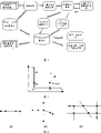
图1为城市交通信息系统结构框架图。Figure 1 is a frame diagram of the urban traffic information system structure.
图2为最近邻法基本原理图。Figure 2 is a schematic diagram of the basic principle of the nearest neighbor method.
图3为车辆轨迹形成前的匹配点分布状况的典型分类示意图。Fig. 3 is a typical classification diagram of the distribution of matching points before the vehicle trajectory is formed.
图4为不确定定位数据修正示意图。Fig. 4 is a schematic diagram of correction of uncertain positioning data.
其中,图4(a)为错误的点匹配图,图4(b)为相应数据修正以后的结果图。Among them, Fig. 4(a) is the wrong point matching map, and Fig. 4(b) is the result map after corresponding data correction.
图5为在市中心繁华地段节选的地图匹配及轨迹跟踪结果的实例。Figure 5 is an example of map matching and trajectory tracking results selected in downtown areas.
图6为城市交通信息平台系统中路网平均行程速度的显示图。Fig. 6 is a display diagram of the average travel speed of the road network in the urban traffic information platform system.
具体实施方式Detailed ways
以下结合附图及具体的实施例对本发明的技术方案作进一步描述。The technical solutions of the present invention will be further described below in conjunction with the accompanying drawings and specific embodiments.
实施例以上海市GIS数据,大众出租车公司提供的3000辆左右出租车GPS数据为实例数据处理,处理周期T为10分钟,周期选择主要考虑到红绿灯周期性和交通行为的周期性变化。实际行进中出租车数据的GPS定位数据间隔20秒,数据较为稀疏,且连续数据间可能跨过一个或多个路段,没有陀螺仪提供的方向数据,无法用到DR算法;城市路网中道路间距小、拓扑结构复杂、信息多样化。The embodiment takes Shanghai GIS data and the GPS data of about 3,000 taxis provided by Volkswagen Taxi Company as an example data processing, and the processing cycle T is 10 minutes. The cycle selection mainly takes into account the periodic changes of traffic lights and traffic behavior. The GPS positioning data interval of the taxi data in actual travel is 20 seconds, the data is relatively sparse, and the continuous data may span one or more road sections, without the direction data provided by the gyroscope, the DR algorithm cannot be used; the road network in the city The spacing is small, the topology is complex, and the information is diverse.
本发明采用如图1所示的处理流程,以实时的GPS车载数据及GIS数据作为输入数据,统一应用最近邻法进行地图匹配,通过A*算法进行车辆轨迹跟踪,再根据车辆数据的前后联系及路况,对不确定定位数据进行判别,处理得到修正后的车辆行驶轨迹,并据此计算单位路段的平均上行速度、下行速度以及综合区间平均速度,显示于数字地图上。本发明中,处理的中间数据及最后的结果统一放在数据库中保存,可用于交通诱导、动态导航等系统。The present invention adopts the processing flow shown in Figure 1, uses real-time GPS vehicle data and GIS data as input data, uniformly applies the nearest neighbor method to carry out map matching, carries out vehicle trajectory tracking through A* algorithm, and then according to the front and back linkage of vehicle data and road conditions, the uncertain positioning data is discriminated, and the corrected vehicle trajectory is processed, and the average uplink speed, downlink speed and comprehensive interval average speed of the unit road section are calculated accordingly, and displayed on the digital map. In the present invention, the processed intermediate data and final results are stored in the database uniformly, and can be used in systems such as traffic guidance and dynamic navigation.
本发明具体实施步骤如下:The specific implementation steps of the present invention are as follows:
1、用最近邻法进行地图匹配1. Use the nearest neighbor method for map matching
将10分钟的出租车GPS数据同时读入,并将位置数据视为散点数据用最近邻法进行统一的地图匹配,将车辆的GPS定位数据修正到车辆行驶的道路上。具体实施时的基本原理如图2所示,即要搜索一段道路,使点P到其投影距离最短,投影点即所求的匹配点。实际操作时,应选定一定区域范围内的路段作为候选道路,加快算法速度。图2中,点P是待匹配点,L1、L2是周围的候选道路,P1、P2为投影点。设A(x1,y1)、B(x2,y2)为候选道路的两端点,k为道路斜率,待匹配点坐标(x,y),投影点坐标(xp,yp)。如图2,当用两点式表示线段方程式时,投影距离公式可表示为:The 10-minute taxi GPS data is read in at the same time, and the location data is regarded as scattered data, and the nearest neighbor method is used for unified map matching, and the GPS positioning data of the vehicle is corrected to the road on which the vehicle is driving. The basic principle of specific implementation is shown in Figure 2, that is, to search for a section of road so that the projected distance from point P to it is the shortest, and the projected point is the desired matching point. In actual operation, road segments within a certain area should be selected as candidate roads to speed up the algorithm. In Figure 2, point P is the point to be matched, L1 and L2 are surrounding candidate roads, and P1 and P2 are projected points. Let A(x 1 , y 1 ), B(x 2 , y 2 ) be the two ends of the candidate road, k is the slope of the road, the coordinates of the point to be matched (x, y), and the coordinates of the projected point (x p , y p ) . As shown in Figure 2, when the line segment equation is represented by a two-point formula, the projection distance formula can be expressed as:
投影点的计算公式为:The formula for calculating the projected point is:
这里的最短投影距离设置阈值为10m,当其值过大时,认为是错误匹配点,过滤掉,得到初步结果。阈值设置综合考虑到了城市路网的密度与GPS数据误差。最近邻法对应的投影点为车辆匹配后的位置,完成从点到线的地图匹配。Here, the minimum projection distance is set to a threshold of 10m. When the value is too large, it is considered as a wrong matching point and filtered out to obtain a preliminary result. The threshold setting takes into account the density of the urban road network and the error of GPS data. The projection point corresponding to the nearest neighbor method is the position of the vehicle after matching, and the map matching from point to line is completed.
2、车辆轨迹的形成2. Formation of vehicle trajectory
对步骤1中得到的分散车辆匹配点,按照匹配点的时间顺序采用A*算法,把前一个时间的车辆匹配点视为初始节点,下一个时间的车辆匹配点视为目标节点,搜索车辆可能达到的整个路网空间图,直至发现目标节点为止,回溯搜索路径,就得到两个点之间的最短路径,记录下来。具体情况分类如图3所示,对于如图3(a)、(b)所示的同一路段和连续路段的情况,处理较简单;对于如图3(c)跨街区的复杂情况,主要用A*算法解决,重点讨论如下:For the scattered vehicle matching points obtained in step 1, the A* algorithm is used according to the time sequence of the matching points, and the vehicle matching point at the previous time is regarded as the initial node, and the vehicle matching point at the next time is regarded as the target node, and the search for possible vehicle The entire road network space graph is reached, until the target node is found, the search path is traced back, and the shortest path between two points is obtained and recorded. The classification of specific situations is shown in Figure 3. For the situation of the same road section and continuous road sections shown in Figure 3(a) and (b), the processing is relatively simple; for the complex situation of crossing blocks as shown in Figure 3(c), the main The A* algorithm is solved, and the key points are as follows:
系统的路网结构是事先得到的固定不变的,属于静态最短路径计算,因此本发明采用了静态最短路径计算中效率较高的A*算法。A*算法属于启发式搜索算法,搜索过程从给定的初始状态开始,搜索整个可能达到的状态空间图,直至发现目标状态为止。启发式搜索优先顺着有启发性和具有特定信息的节点搜索下去,这些节点可能是达到目标节点的最佳路径上的节点。在启发式搜索中,启发函数的设计将决定搜索时耗以及能否寻找到最优解,是算法的关键。本发明中A*算法的评价函数定义为:The road network structure of the system is fixed in advance and belongs to the calculation of the static shortest path. Therefore, the present invention adopts the A* algorithm with high efficiency in the calculation of the static shortest path. The A* algorithm is a heuristic search algorithm. The search process starts from a given initial state and searches the entire possible state space graph until the target state is found. The heuristic search preferentially searches along the heuristic and specific information nodes, which may be the nodes on the best path to reach the target node. In the heuristic search, the design of the heuristic function will determine the search time and whether the optimal solution can be found, which is the key to the algorithm. The evaluation function of A* algorithm is defined as:
f(n)=g(n)+h(n) (3)f(n)=g(n)+h(n) (3)
其中,1)f(n)是从初始点通过节点n到达目标点的估价函数;Among them, 1) f(n) is the evaluation function from the initial point to the target point through node n;
2)g(n)是在状态空间中从初始节点到n节点的实际代价,g(n)的定义式为:2) g(n) is the actual cost from the initial node to n nodes in the state space, and the definition of g(n) is:
g(n)=d(n)+αc(n) (4)g(n)=d(n)+αc(n) (4)
d(n)为起始点到节点n实际轨迹的长度,c(n)为节点n的扩展层数,α是两者的比例因子。d(n) is the length of the actual trajectory from the starting point to node n, c(n) is the number of extended layers of node n, and α is the scaling factor of the two.
3)h(n)是从节点n到目标节点最佳路径的估计代价。它决定了搜索的效率和可采纳性。对于几何路网来说,可以取两点间欧氏距离作为估价值,由于估价值h(n)≤n到目标节点的距离实际值,算法具有可采纳性,能得到最优解。3) h(n) is the estimated cost of the best path from node n to the target node. It determines the efficiency and admissibility of the search. For the geometric road network, the Euclidean distance between two points can be taken as the estimated value. Since the estimated value h(n) ≤ the actual value of the distance from n to the target node, the algorithm is admissible and the optimal solution can be obtained.
对以上公式进行修改,可以得到几个不同的有实用意义的估价函数:By modifying the above formula, several different valuation functions with practical significance can be obtained:
1)当d(n)=0时,f(n)=g(n)+h(n)=c(n)+h(n),评估准则意味着车辆选择交叉路口和转弯较少的状况简单的道路行驶。1) When d(n)=0, f(n)=g(n)+h(n)=c(n)+h(n), the evaluation criterion means that the vehicle chooses the intersection and turns less Easy road driving.
2)当c(n)=0时,f(n)=g(n)+h(n)=d(n)+h(n),评估准则意味着车辆选择路径距离最短的道路行驶。2) When c(n)=0, f(n)=g(n)+h(n)=d(n)+h(n), the evaluation criterion means that the vehicle chooses the road with the shortest path distance.
3)当d(n)=0,h(n)=0,算法本质为广度优先算法。3) When d(n)=0, h(n)=0, the essence of the algorithm is a breadth-first algorithm.
按上述方法依次连接每辆车的所有匹配点,形成车辆轨迹,完成整个车辆行驶轨迹线与城市道路的匹配。对所有车辆进行同样处理,得到路网中所有车辆的行驶轨迹。According to the above method, all matching points of each vehicle are connected in turn to form a vehicle trajectory, and the matching of the entire vehicle trajectory line with the urban road is completed. Perform the same processing on all vehicles to obtain the driving trajectories of all vehicles in the road network.
3、不确定定位数据的判别与处理3. Discrimination and processing of uncertain positioning data
根据投影距离和同一车辆行驶轨迹上临近点所在道路的信息计算匹配点的可信度,投影距离越大匹配点可信度越低,孤立于临近点所在道路的匹配点可信度也设为低。另一个直观并关键的评价原则为:在路口有折返行为,即连续通过相同路径两次的匹配点可直接列入不确定车辆定位数据点。其次对不确定车辆定位数据点向步骤2中得到的车辆行驶轨迹所在道路进行投影,若投影距离在阈值内,不确定车辆定位数据点修改成功,按照新的匹配点修正该段的车辆行驶轨迹;反之,不确定车辆定位数据点修改失败,认为车辆原来的行驶轨迹匹配正确。如图4所示,点A、B、C分别为车辆行驶轨迹上的按时间顺序排列的匹配点,判断B为不确定匹配点。图4(a)中,先不考虑点B,用A*算法找出点A到C的路径TAC,然后完成点B到TAC投影,因为投影距离在阈值内,修改成功,重新按照新的匹配点修正该段的车辆行驶轨迹,如图4(b)为修正后的车辆行驶轨迹。图5为在市中心繁华地段节选的地图匹配及轨迹跟踪结果的实例,图中圆圈标记的位置根据以上步骤修改的不确定定位数据的实例。对所有车辆进行同样处理,得到路网中所有车辆修正后的行驶轨迹。The credibility of the matching point is calculated according to the projection distance and the information of the road where the adjacent point is located on the same vehicle trajectory. The larger the projection distance is, the lower the reliability of the matching point is. The reliability of the matching point isolated from the road where the adjacent point is located is also set to Low. Another intuitive and key evaluation principle is: there is a turn-back behavior at the intersection, that is, matching points that have passed the same path twice in a row can be directly included in the uncertain vehicle positioning data points. Secondly, project the uncertain vehicle positioning data points to the road where the vehicle trajectory obtained in step 2 is located. If the projection distance is within the threshold, the uncertain vehicle positioning data points are modified successfully, and the vehicle trajectory of this segment is corrected according to the new matching points. ; On the contrary, it is uncertain that the modification of the vehicle positioning data point fails, and it is considered that the original driving trajectory of the vehicle is matched correctly. As shown in Figure 4, points A, B, and C are matching points arranged in chronological order on the vehicle trajectory, and it is judged that B is an uncertain matching point. In Figure 4(a), ignore point B first, use the A* algorithm to find out the path T AC from point A to C, and then complete the projection from point B to T AC , because the projected distance is within the threshold, the modification is successful, and then follow the new The matching points correct the vehicle trajectory of this segment, as shown in Figure 4(b) for the corrected vehicle trajectory. Figure 5 is an example of the map matching and trajectory tracking results selected in the bustling area of the city center. The position marked by the circle in the figure is an example of the uncertain positioning data modified according to the above steps. Perform the same processing on all vehicles to obtain the corrected driving trajectories of all vehicles in the road network.
不确定车辆定位数据点主要是因为最近邻法得到的初步定位数据没有考虑车辆数据的前后联系,其主要出现在道路交叉口,而这种交叉路口处的车辆匹配一直是地图匹配的重点和难点。本步骤基于如下假设:在两个匹配点之间,车辆正常行驶,即车辆可选择最短道路路径或最简单路径行驶。最简单路径指车辆在两个测得的GPS车载定位数据点之间经过道路节点最少,行驶路径的结构最简单。本步骤以已有的初步定位和车辆轨迹数据为良好基础,进一步考虑到车辆的历史数据和后续数据,对不确定车辆定位数据点进行处理和纠正,并得到修正过的更精确的车辆轨迹。Uncertain vehicle positioning data points are mainly because the preliminary positioning data obtained by the nearest neighbor method does not consider the context of vehicle data, which mainly appear at road intersections, and vehicle matching at such intersections has always been the focus and difficulty of map matching . This step is based on the following assumption: between the two matching points, the vehicle travels normally, that is, the vehicle can choose the shortest road path or the simplest path to travel. The simplest path means that the vehicle passes the fewest road nodes between two measured GPS vehicle positioning data points, and the structure of the driving path is the simplest. This step takes the existing preliminary positioning and vehicle trajectory data as a good basis, further considers the historical data and follow-up data of the vehicle, processes and corrects the uncertain vehicle positioning data points, and obtains a corrected and more accurate vehicle trajectory.
4、路网区间平均速度计算4. Calculate the average speed of the road network interval
首先由步骤3中修正后的单辆车行驶轨迹提供的车辆位置信息与所在道路信息得到车辆在轨迹上的路程值,再利用GPS车辆数据中的时间信息,两者相除得到车辆在行驶轨迹上行程速度。行程速度的估计取包含交通流周期信息的道路交叉点分段,根据车辆轨迹估计车辆通过道路交叉点时的速度与时间。对路网中的每辆车用相同方法得到所有车辆在行驶轨迹上的行程速度。然后以路段为基本单位,找出在规定时间内行驶在指定路段上的所有车辆,对这些车辆的速度做滤波处理,对滤波后所有车辆的速度取几何平均值,得到该路段的道路区间平均速度,从而得到路网区间平均速度;考虑车辆通过道路节点顺序的不同,得到车辆在道路上的不同行驶方向,从而将车辆的速度信息分类,得到道路的平均上行速度、下行速度。动态显示于GIS地图上,如图6所示,城市交通信息系统以不同的颜色对路网平均行程速度进行区分和显示。Firstly, the distance value of the vehicle on the track is obtained from the vehicle position information and the road information provided by the corrected single vehicle track in step 3, and then the time information in the GPS vehicle data is used to divide the two to obtain the vehicle track Upstroke speed. The estimation of travel speed takes the road intersection segment containing traffic flow period information, and estimates the speed and time when the vehicle passes through the road intersection according to the vehicle trajectory. Use the same method for each vehicle in the road network to obtain the travel speed of all vehicles on the driving track. Then take the road section as the basic unit, find out all the vehicles driving on the specified road section within the specified time, filter the speed of these vehicles, take the geometric mean value of the speed of all vehicles after filtering, and get the road interval average of the road section Speed, so as to obtain the average speed of the road network interval; considering the different order of vehicles passing through road nodes, different driving directions of vehicles on the road can be obtained, so as to classify the speed information of vehicles to obtain the average uplink speed and downlink speed of the road. Dynamically displayed on the GIS map, as shown in Figure 6, the urban traffic information system distinguishes and displays the average travel speed of the road network in different colors.
Claims (1)
Priority Applications (1)
| Application Number | Priority Date | Filing Date | Title |
|---|---|---|---|
| CNB2005100263968A CN100357987C (en) | 2005-06-02 | 2005-06-02 | Method for obtaining average speed of city rode traffic low region |
Applications Claiming Priority (1)
| Application Number | Priority Date | Filing Date | Title |
|---|---|---|---|
| CNB2005100263968A CN100357987C (en) | 2005-06-02 | 2005-06-02 | Method for obtaining average speed of city rode traffic low region |
Publications (2)
| Publication Number | Publication Date |
|---|---|
| CN1710624A CN1710624A (en) | 2005-12-21 |
| CN100357987C true CN100357987C (en) | 2007-12-26 |
Family
ID=35706862
Family Applications (1)
| Application Number | Title | Priority Date | Filing Date |
|---|---|---|---|
| CNB2005100263968A Expired - Fee Related CN100357987C (en) | 2005-06-02 | 2005-06-02 | Method for obtaining average speed of city rode traffic low region |
Country Status (1)
| Country | Link |
|---|---|
| CN (1) | CN100357987C (en) |
Families Citing this family (34)
| Publication number | Priority date | Publication date | Assignee | Title |
|---|---|---|---|---|
| CN1888931B (en) * | 2006-08-03 | 2010-05-12 | 上海交通大学 | GPS-based double-satellite positioning and navigation method |
| CN100452109C (en) * | 2006-10-19 | 2009-01-14 | 上海交通大学 | Method for obtaining everage speed of city road section traffic flow |
| KR100822010B1 (en) * | 2006-11-30 | 2008-04-15 | 에스케이에너지 주식회사 | Traffic information providing system and method using digital map for collecting traffic information |
| CN101206644B (en) * | 2006-12-18 | 2010-05-12 | 厦门雅迅网络股份有限公司 | Data Processing Method of Vehicle Trajectory |
| CN100463407C (en) * | 2006-12-25 | 2009-02-18 | 北京世纪高通科技有限公司 | Method and system for real-time dynamic traffic information collecting, handling, and issuing |
| CN100463009C (en) * | 2006-12-25 | 2009-02-18 | 北京世纪高通科技有限公司 | A traffic information fusion processing method and system |
| CN100466010C (en) * | 2007-02-08 | 2009-03-04 | 上海交通大学 | Real-time Fusion Method of Heterogeneous Traffic Information |
| CN101270997B (en) * | 2007-03-21 | 2010-07-28 | 北京交通发展研究中心 | Floating car dynamic real-time traffic information processing method based on GPS data |
| SG171698A1 (en) * | 2008-12-23 | 2011-07-28 | Tomtom Int Bv | Navigation device and method for determining a route of travel |
| JP5702794B2 (en) * | 2009-10-27 | 2015-04-15 | アルカテル−ルーセント | Improved reliability of travel time estimation |
| CN102063789B (en) * | 2009-11-16 | 2014-07-30 | 高德软件有限公司 | Traffic information quality evaluation method and device |
| CN102175253B (en) * | 2010-12-28 | 2012-09-05 | 清华大学 | Multi-hypothesis map matching method based on vehicle state transition |
| CN102122435B (en) * | 2011-03-18 | 2014-09-17 | 北京世纪高通科技有限公司 | Method and device for positioning traffic event information |
| CN103903433B (en) * | 2012-12-27 | 2016-09-14 | 南京中兴新软件有限责任公司 | The Real-time and Dynamic method of discrimination of a kind of road traffic state and device |
| CN103218406B (en) * | 2013-03-21 | 2019-11-26 | 百度在线网络技术(北京)有限公司 | The processing method and equipment of the address information of point of interest |
| CN103700258A (en) * | 2013-12-09 | 2014-04-02 | 深圳市中兴云服务有限公司 | Road condition information acquisition method and device |
| CN103700156A (en) * | 2013-12-18 | 2014-04-02 | 北京邮电大学 | GIS (Geographic Information System)-based optical network patrolling method |
| CN103822638B (en) * | 2014-02-19 | 2017-07-07 | 华为技术有限公司 | The treating method and apparatus of customer position information |
| CN105006167A (en) * | 2014-04-18 | 2015-10-28 | 杭州远眺科技有限公司 | Research method for traffic jam propagation path |
| CN104484999B (en) * | 2014-12-31 | 2017-08-22 | 百度在线网络技术(北京)有限公司 | The method and device of dynamic information is determined based on user trajectory |
| CN105225479A (en) * | 2015-08-21 | 2016-01-06 | 西南交通大学 | Based on the signalized intersections Link Travel Time computing method of mobile phone switch data |
| CN106652556A (en) * | 2015-10-28 | 2017-05-10 | 中国移动通信集团公司 | Human-vehicle anti-collision method and apparatus |
| CN105989714A (en) * | 2016-01-13 | 2016-10-05 | 合肥工业大学 | Unidirectional multilane vehicle low speed early warning system based on microwave radar |
| CN106251642B (en) * | 2016-09-18 | 2018-10-26 | 北京航空航天大学 | A kind of public transport road chain speed calculation method based on real-time bus GPS data |
| CN107331159A (en) * | 2017-08-17 | 2017-11-07 | 上海交通大学 | A kind of traffic major trunk roads velocity estimation apparatus based on coil checker data |
| CN109872533B (en) * | 2019-02-21 | 2020-12-04 | 弈人(上海)科技有限公司 | Lane-level real-time traffic information processing method based on spatial data |
| CN113221602B (en) * | 2020-01-21 | 2023-09-29 | 百度在线网络技术(北京)有限公司 | Road pavement condition determination methods, devices, equipment and media |
| CN112255652A (en) * | 2020-11-26 | 2021-01-22 | 中铁第五勘察设计院集团有限公司 | Method and system for matching Beidou vehicle positioning data and railway line data |
| CN112988938A (en) * | 2021-03-31 | 2021-06-18 | 深圳一清创新科技有限公司 | Map construction method and device and terminal equipment |
| CN113611130B (en) * | 2021-08-03 | 2023-08-25 | 中国环境科学研究院 | A method, system and storage medium for acquiring local and transit truck traffic |
| CN113990067A (en) * | 2021-10-26 | 2022-01-28 | 南京渊木灏计算机技术有限公司 | GIS traffic emergency management system |
| CN114777798B (en) * | 2022-04-29 | 2025-08-01 | 重庆城市交通开发投资(集团)有限公司数智科技分公司 | 3D real-time map and 3D track playback system of Internet of vehicles |
| CN115935000B (en) * | 2023-02-24 | 2023-06-30 | 广东瑞恩科技有限公司 | Intelligent storage method and system for data of Internet of things |
| CN117173911B (en) * | 2023-07-25 | 2024-11-12 | 太极计算机股份有限公司 | Traffic flow allocation method and system suitable for vehicle-road collaboration in intelligent transportation operation |
Citations (3)
| Publication number | Priority date | Publication date | Assignee | Title |
|---|---|---|---|---|
| JPH07282387A (en) * | 1994-04-12 | 1995-10-27 | Nippon Signal Co Ltd:The | Method for measuring speed of vehicle |
| JPH0991586A (en) * | 1995-09-26 | 1997-04-04 | Babcock Hitachi Kk | Method and device for monitoring road state |
| CN1560756A (en) * | 2004-03-09 | 2005-01-05 | 北京交通大学 | A method for processing intelligent traffic data |
-
2005
- 2005-06-02 CN CNB2005100263968A patent/CN100357987C/en not_active Expired - Fee Related
Patent Citations (3)
| Publication number | Priority date | Publication date | Assignee | Title |
|---|---|---|---|---|
| JPH07282387A (en) * | 1994-04-12 | 1995-10-27 | Nippon Signal Co Ltd:The | Method for measuring speed of vehicle |
| JPH0991586A (en) * | 1995-09-26 | 1997-04-04 | Babcock Hitachi Kk | Method and device for monitoring road state |
| CN1560756A (en) * | 2004-03-09 | 2005-01-05 | 北京交通大学 | A method for processing intelligent traffic data |
Non-Patent Citations (2)
| Title |
|---|
| 市区路网服务水平评价 朱顺应,王红,王毅.重庆交通学院学报,第17卷第4期 1998 * |
| 道路交通工程中的车速含义及其应用 王德章.辽宁警专学报,第1期 2005 * |
Also Published As
| Publication number | Publication date |
|---|---|
| CN1710624A (en) | 2005-12-21 |
Similar Documents
| Publication | Publication Date | Title |
|---|---|---|
| CN100357987C (en) | Method for obtaining average speed of city rode traffic low region | |
| Davies et al. | Scalable, distributed, real-time map generation | |
| US20210004363A1 (en) | Updating high definition maps based on age of maps | |
| CN112991743B (en) | Real-time traffic risk AI prediction method based on driving path and system thereof | |
| CN100580735C (en) | Real-time dynamic traffic information processing method based on probe car technology | |
| CN108345666B (en) | Vehicle abnormal track detection method based on time-space isolated points | |
| EP4001843A1 (en) | Method, apparatus, and system for creating doubly-digitised maps | |
| CN108961758B (en) | Road junction widening lane detection method based on gradient lifting decision tree | |
| CN113932821A (en) | Trajectory map matching method based on continuous window average direction feature | |
| CN103038605A (en) | Detecting location, timetable and travel time estimations for barrier crossings in a digital map | |
| US11393334B2 (en) | Method, apparatus, and computer program product for detecting changes in road traffic condition | |
| CN102200446B (en) | Continuous path detection device and method based on traffic data | |
| US11946769B2 (en) | Method, apparatus, and system for identifying special areas and cleaning-up map data | |
| EP3671126B1 (en) | Method, apparatus, and system for providing road closure graph inconsistency resolution | |
| CN113259900A (en) | Distributed multi-source heterogeneous traffic data fusion method and device | |
| CN109520499B (en) | Method for realizing regional real-time isochrones based on vehicle GPS track data | |
| CN117782126A (en) | High-precision map-guided autonomous driving path planning and decision-making method | |
| CN114676917B (en) | A method and system for evaluating the spatial distribution of empty taxis | |
| CN116698054B (en) | Road matching method, device, electronic equipment and storage medium | |
| CN103854479A (en) | Method and device for measuring traffic flow data of road segment without detector | |
| CN115798212A (en) | Traffic jam detection method based on taxi track | |
| CN115352453A (en) | Lane-level congestion avoidance guidance method, system, vehicle and storage medium | |
| TW201327458A (en) | Transportation route network generation method using vehicle detection data | |
| CN109165245B (en) | Time-space mode mining method of mobile trajectory generation model for multi-source data fusion | |
| EP4517264A2 (en) | Snap to road, popular routes, popular stops, predicting roadway speed, and contiguous region identification |
Legal Events
| Date | Code | Title | Description |
|---|---|---|---|
| C06 | Publication | ||
| PB01 | Publication | ||
| C10 | Entry into substantive examination | ||
| SE01 | Entry into force of request for substantive examination | ||
| C14 | Grant of patent or utility model | ||
| GR01 | Patent grant | ||
| C17 | Cessation of patent right | ||
| CF01 | Termination of patent right due to non-payment of annual fee |
Granted publication date: 20071226 Termination date: 20100602 |