KR20180104956A - System for managing drone - Google Patents
System for managing drone Download PDFInfo
- Publication number
- KR20180104956A KR20180104956A KR1020170031911A KR20170031911A KR20180104956A KR 20180104956 A KR20180104956 A KR 20180104956A KR 1020170031911 A KR1020170031911 A KR 1020170031911A KR 20170031911 A KR20170031911 A KR 20170031911A KR 20180104956 A KR20180104956 A KR 20180104956A
- Authority
- KR
- South Korea
- Prior art keywords
- drones
- unmanned
- drone
- flight
- dronemanager
- Prior art date
- Legal status (The legal status is an assumption and is not a legal conclusion. Google has not performed a legal analysis and makes no representation as to the accuracy of the status listed.)
- Granted
Links
Images




Classifications
-
- G—PHYSICS
- G06—COMPUTING OR CALCULATING; COUNTING
- G06Q—INFORMATION AND COMMUNICATION TECHNOLOGY [ICT] SPECIALLY ADAPTED FOR ADMINISTRATIVE, COMMERCIAL, FINANCIAL, MANAGERIAL OR SUPERVISORY PURPOSES; SYSTEMS OR METHODS SPECIALLY ADAPTED FOR ADMINISTRATIVE, COMMERCIAL, FINANCIAL, MANAGERIAL OR SUPERVISORY PURPOSES, NOT OTHERWISE PROVIDED FOR
- G06Q50/00—Information and communication technology [ICT] specially adapted for implementation of business processes of specific business sectors, e.g. utilities or tourism
- G06Q50/10—Services
-
- B—PERFORMING OPERATIONS; TRANSPORTING
- B64—AIRCRAFT; AVIATION; COSMONAUTICS
- B64C—AEROPLANES; HELICOPTERS
- B64C39/00—Aircraft not otherwise provided for
- B64C39/02—Aircraft not otherwise provided for characterised by special use
- B64C39/024—Aircraft not otherwise provided for characterised by special use of the remote controlled vehicle type, i.e. RPV
-
- G—PHYSICS
- G08—SIGNALLING
- G08B—SIGNALLING SYSTEMS, e.g. PERSONAL CALLING SYSTEMS; ORDER TELEGRAPHS; ALARM SYSTEMS
- G08B21/00—Alarms responsive to a single specified undesired or abnormal condition and not otherwise provided for
- G08B21/18—Status alarms
- G08B21/182—Level alarms, e.g. alarms responsive to variables exceeding a threshold
-
- G—PHYSICS
- G08—SIGNALLING
- G08G—TRAFFIC CONTROL SYSTEMS
- G08G5/00—Traffic control systems for aircraft
- G08G5/80—Anti-collision systems
-
- H—ELECTRICITY
- H04—ELECTRIC COMMUNICATION TECHNIQUE
- H04W—WIRELESS COMMUNICATION NETWORKS
- H04W4/00—Services specially adapted for wireless communication networks; Facilities therefor
- H04W4/02—Services making use of location information
- H04W4/029—Location-based management or tracking services
-
- B64C2201/12—
-
- B64C2201/146—
-
- B—PERFORMING OPERATIONS; TRANSPORTING
- B64—AIRCRAFT; AVIATION; COSMONAUTICS
- B64U—UNMANNED AERIAL VEHICLES [UAV]; EQUIPMENT THEREFOR
- B64U2101/00—UAVs specially adapted for particular uses or applications
- B64U2101/30—UAVs specially adapted for particular uses or applications for imaging, photography or videography
- B64U2101/31—UAVs specially adapted for particular uses or applications for imaging, photography or videography for surveillance
-
- B—PERFORMING OPERATIONS; TRANSPORTING
- B64—AIRCRAFT; AVIATION; COSMONAUTICS
- B64U—UNMANNED AERIAL VEHICLES [UAV]; EQUIPMENT THEREFOR
- B64U2201/00—UAVs characterised by their flight controls
- B64U2201/20—Remote controls
Landscapes
- Business, Economics & Management (AREA)
- Engineering & Computer Science (AREA)
- Tourism & Hospitality (AREA)
- General Physics & Mathematics (AREA)
- Physics & Mathematics (AREA)
- Aviation & Aerospace Engineering (AREA)
- Strategic Management (AREA)
- Health & Medical Sciences (AREA)
- Marketing (AREA)
- Primary Health Care (AREA)
- General Health & Medical Sciences (AREA)
- Economics (AREA)
- General Business, Economics & Management (AREA)
- Human Resources & Organizations (AREA)
- Theoretical Computer Science (AREA)
- Emergency Management (AREA)
- Computer Networks & Wireless Communication (AREA)
- Signal Processing (AREA)
- Control Of Position, Course, Altitude, Or Attitude Of Moving Bodies (AREA)
- Traffic Control Systems (AREA)
Abstract
비행 허용 구역을 설정하여 적어도 하나의 무인 드론의 비행을 모니터링하는 드론 관제 서버와 무인 드론에 마련되어 무인 드론의 고도와 좌표를 검출하고, 미리 설정된 통신 프로토콜에 따라 상기 검출된 고도와 좌표를 전송하는 드론 관리기와 상기 위치 관리기에서 검출된 무인 드론의 고도와 좌표에 기초하여 생성된 위치 정보와 상기 비행 허용 구역에 대한 정보를 표시하는 사용자 단말을 포함하는 드론 관리 시스템을 제공한다.A dron control server for monitoring the flight of at least one unmanned drones by setting a flight allowable zone and a drones for detecting the altitude and coordinates of the unmanned drones and transmitting the detected altitude and coordinates according to a predetermined communication protocol, And a user terminal for displaying location information generated based on the altitude and coordinates of the unmanned drones detected by the manager, and information on the allowed flying zones.
Description
본 발명은 드론 관리 시스템에 관한 것으로, 더 상세하게는 무인 드론의 비행에 대한 정보를 관리하여 위험을 예측하고, 예측된 위험에 따라 무인 드론의 비행을 관리하는 드론 관리 시스템에 관한 것이다.The present invention relates to a drones management system, and more particularly, to a drones management system that manages information about an unmanned drones flight to predict the risk and manages the flight of the unmanned drones according to a predicted risk.
무인 드론은 조종사를 탑승하지 않고 비행하는 비행체를 의미하는 것으로, 무인 드론은 수평 추력과 수직 추력을 모두 생성되어 수직이착륙(vertical takeoff and landing, VTOL) 기능이 탑재될 수 있다. 프로펠러나 로터는 수직방향으로 추력을 생성하여 비행체를 들어올리고, 수평방향으로 추력을 생성하여 전방으로 움직임을 제공할 수 있다. Unmanned drones mean flying objects without flying a pilot. Unmanned drones can be equipped with vertical takeoff and landing (VTOL) functions by generating both horizontal thrust and vertical thrust. The propeller or rotor can create a thrust force in the vertical direction to lift the air vehicle, and generate thrust in the horizontal direction to provide forward motion.
종래, 무인 드론은 군사용 또는 정찰용으로 사용하여 적의 정찰하거나 지형을 탐색하여 정보를 수집하여 사용되었다. 항공기술 또는 통신기술이 발전함에 따라 그 수요가 증가하고 있으며, 최근에는 영상 촬영용 또는 취미용 무인 드론이 급속도로 보급되고 있다. Conventionally, unmanned drones were used for military or reconnaissance purposes, used to scout enemies or search for terrain and collect information. As aviation technology or communication technology develops, the demand is increasing. Recently, unmanned drones for image capture or hobby are rapidly spreading.
이와 같은 무인 드론의 일반적인 보급에 따라 무인 드론의 비행으로 각종 문제가 발생하여, 무인 드론의 비행에 대한 적절한 통제 방법이 요구되고 있다. Due to the general spread of the unmanned drones, various problems arise due to the unmanned drones' flight, and proper control methods of unmanned drones are required.
상술한 문제점을 해결하기 위해 복수의 무인 드론의 비행과 관련된 정보를 제공하고, 무인 드론에서 발생하는 각종 위험 상황을 인지하여 경고하는 드론 관리 시스템을 제공하는 것에 목적이 있다. It is an object of the present invention to provide a drones management system which provides information related to a plurality of unmanned drones in order to solve the above-described problems, and alerts and warns of various dangerous situations occurring in unmanned drones.
상술한 과제를 해결하기 위한 일 실시예에 따른 드론 관리 시스템은 비행 허용 구역을 설정하여 적어도 하나의 무인 드론의 비행을 모니터링하는 드론 관제 서버;와 무인 드론에 마련되어 무인 드론의 고도와 좌표를 검출하고, 미리 설정된 통신 프로토콜에 따라 상기 검출된 고도와 좌표를 전송하는 제1 드론 관리기;와 상기 드론 관제 서버로부터 상기 제1 관리기에서 검출된 무인 드론의 고도와 좌표에 기초하여 생성된 위치 정보와 상기 비행 허용 구역에 대한 정보를 수신하여 표시하는 제2 드론 관리기;를 포함한다.According to an aspect of the present invention, there is provided a drones management system, comprising: a dron control server for monitoring a flight of at least one unmanned drones by establishing a flight allowable zone; and an unmanned dron for detecting altitude and coordinates of the unmanned drones, A first dronemanagement server for transmitting the detected altitude and coordinates according to a preset communication protocol, a first dronemanagement server for transmitting the detected altitude and coordinates according to a predetermined communication protocol, And a second drones manager for receiving and displaying information on the permitted zones.
이때, 상기 드론 관제 서버는, 상기 위치 정보에 기초하여 무인 드론이 상기 비행 허용 구역을 이탈할 가능성을 산출하고, 산출된 가능성이 미리 설정된 임계값 이상이면 상기 제2 드론 관리기에 이탈 경고를 푸쉬할 수 있다. At this time, the drone control server calculates the possibility that the unmanned drone will leave the flight allowance zone based on the location information, and pushes the departure warning to the second drones manager if the calculated possibility is equal to or greater than a preset threshold value .
또한, 상기 드론 관제 서버는, 상기 무인 드론과 미리 설정된 거리 이내를 비행하는 주변 무인 드론을 탐색하여 주변 드론 정보를 생성하여 상기 제2 드론 관리기로 전송하고,상기 제2 드론 관리기는, 상기 위치 정보 및 상기 주변 드론 정보에 기초하여 상기 무인 드론과 상기 주변 무인 드론의 상태 위치를 표시할 수 있다.In addition, the drones control server searches for peripheral unmanned drones flying within a predetermined distance from the unmanned drones to generate and transmit the peripheral dron information to the second drones manager, And a state position of the unmanned drones and the surrounding unillustrated drones based on the peripheral dron information.
또한, 상기 드론 관제 서버는, 상기 주변 무인 드론과 상기 무인 드론의 거리가 미리 설정된 위험 거리보다 좁아지면 상기 제2 드론 관리기로 충돌 경고를 푸쉬할 수 있다. In addition, the drone control server may push the collision warning to the second dronemanagement unit when the distance between the surrounding unmanned drones and the unmanned drones is narrower than a preset danger distance.
또한, 상기 드론 관제 서버는, 상기 무인 드론과 미리 설정된 거리 이내에 비행하는 주변 무인 드론의 오작동이 감지되면, 상기 제2 드론 관리기로 오작동 경고를 푸쉬할 수 있다.In addition, the drones control server may push the malfunction warning to the second dronemanagement unit when a malfunction of the surrounding unmanned drones flying within a predetermined distance from the unladen drones is detected.
또한, 상기 드론 관제 서버는, 상기 미리 설정된 거리 이내에 비행하는 주변 무인 드론의 비행 궤적이 미리 설정된 정상 궤적 범위를 벗어나면 상기 주변 무인 드론이 오작동하는 것으로 판단할 수 있다. In addition, the drone control server can determine that the surrounding unmanned drones malfunction when the flight trajectory of the surrounding unmanned drones flying within the predetermined distance deviates from a preset normal trajectory range.
또한, 상기 제1 드론 관리기는, 빛 또는 소리를 발생하는 상기 무인 드론의 상기 비행 허용 구역 이탈 위험, 상기 무인 드론과 주변 무인 드론의 충돌 위험, 및 상기 주변 무인 드론의 오작동 위험 중 적어도 하나의 위험에 대하여 경고를 제공하는 위험 경고부;를 더 포함할 수 있다.In addition, the first dronemanager may include at least one of a risk of the risk of the unmanned drones emitting light or sound to the flying allowable zone, a risk of collision between the unmanned drones and the surrounding unladen drone, And a danger warning section for providing a warning to the user.
또한, 상기 제1 드론 관리기는, 상기 제2 드론 관리기 또는 상기 드론 관제 장치의 제어 신호에 따라 동작하여 상기 무인 드론의 낙하 속도를 감소시키는 안전 낙하기;를 더 포함할 수 있다.The first dronemanager may further include a safety dropper which operates in response to a control signal of the second dronemanager or the dron controller to reduce the dropping speed of the unmanned drones.
또한, 다른 무인 드론을 포획하기 위한 수단을 포함하여 상기 비행 허용 구역을 비행하는 드론을 관리하는 페트롤 드론;을 더 포함하고, 상기 드론 관제 서버는, 상기 제2 드론 관리기로부터 응급 신호가 입력되면, 상기 페트롤 드론이 상기 제2 드론 관리기에 대응되는 상기 제1 드론 관리기의 위치로 이동하도록 제어하고, 상기 제1 드론 관리기가 부착된 무인 드론을 포획하여 미리 설정된 안정 위치로 상기 페트롤 드론이 이동하도록 제어할 수 있다.The drones control server may further include a petrol drone for managing a dron flying the flying allowable area including means for capturing another unmanned drones, wherein when the emergency signal is input from the second dronemanager, The control unit controls the petrol drone to move to the position of the first dronemanagement unit corresponding to the second dronemanagement unit so that the petrol drone can move to the preset stable position by capturing the unmanned dronon attached to the first dronon management unit can do.
또한, 다른 무인 드론을 포획하기 위한 수단을 포함하여 상기 비행 허용 구역을 비행하는 드론을 관리하는 페트롤 드론;을 더 포함하고, 상기 드론 관제 서버는, 무인 드론의 상기 비행 허용 구역 이탈 위험이 감지되거나, 상기 비행 허용 구역을 이탈하는 이탈 드론이 감지되면, 상기 페트롤 드론을 상기 이탈 드론에 마련되 제1 드론 관리기의 위치로 이동하도록 제어하고, 상기 제1 드론 관리기가 부착된 이탈 드론을 포획하여 미리 설정된 안정 위치로 상기 페트롤 드론이 이동하도록 제어할 수 있다.The drones control server may further include a petrol drone for managing a dron flying the allowable area including means for capturing another unmanned drones, A control unit for controlling the petrol drone to move to the position of the first dronemanager provided in the departing dronon if the departing dronon deviating from the flight allowable area is detected, It is possible to control the movement of the petrol drone to the set stable position.
또한, 상기 비행 허용 구역에 대한 영상을 획득하는 제1 카메라;와 다른 무인 드론을 포획하기 위한 수단 및 주변에 대한 영상을 획득하는 제2 카메라을 포함하여 상기 비행 허용 구역을 비행하는 드론을 관리하기 위한 페트롤 드론;을 더 포함하고, 상기 드론 관제 서버는, 제1 카메라 또는 제2 카메라를 통해 획득된 영상을 분석하여, 상기 비행 허용 구역을 비행하는 드론의 위치를 분석하여 상기 비행 허용 구역을 비행하는 드론의 위치맵을 생성하고, 상기 위치맵과 제1 드론 관리기에서 검출된 각 드론의 위치를 비교하여 제1 드론 관리기가 부착되지 않은 무허가 무인 드론을 특정하고, 상기 무허가 드론을 포획하여 상기 무허가 무인 드론이 미리 설정된 안전 위치로 이동하도록 상기 페트롤 드론을 제어할 수 있다. In order to manage the drones flying in the flight-allowed zone, a first camera for acquiring an image for the flight-allowed zone, a means for capturing another unmanned drones, and a second camera for acquiring images for the surroundings, The drone control server analyzes the image obtained through the first camera or the second camera to analyze the position of the dron flying in the flight allowable area, The location map of the drones is generated, and the location map is compared with the position of each dron detected by the first dronemanagement device to specify an unauthorized unmanned dronon to which the first dronemanagement device is not attached, and the unauthorized dronon is captured, It is possible to control the petrol drone so that the drones move to the predetermined safety position.
또한, 상기 비행 허용 구역의 주변에 적어도 하나 이상 설치되고, 상기 드론 관리 서버, 제1 드론 관리기 및 제2 드론 관리기로 설치 지점에 대한 기준위치정보를 제공하는 센서부를 더 포함할 수 있다.In addition, at least one or more sensors installed at the periphery of the flight allowable area may be provided to provide the reference position information to the drones management server, the first drones manager, and the second drones manager.
제1 드론 관리기에서 검출된 위치 정보와 비행 허용 구역에 대한 정보를 함께 표시하는 드론 관리 시스템을 제공함으로써, 무인 드론이 비행 허용 구역 내에서 비행하도록 가이드할 수 있다. The drones can be guided to fly within the flight allowance zone by providing the drones management system that displays the location information detected by the first drones manager and the information on the flight allowed zones together.
또한, 비행 허용 구역 이탈, 충돌 경고, 오작동 경고를 제2 드론 관리기 또는 제1 드론 관리기를 통해 제공함으로써, 무인 드론의 비행시에 발생하는 각종 위험 상황에 대한 조기 경고를 제공할 수 있다. In addition, by providing the flight allowable range departure, collision warning, and malfunction warning through the second dronemanagement unit or the first dronemanagement unit, it is possible to provide an early warning of various dangerous situations occurring during flight of the unmanned drones.
또한, 제1 드론 관리기가 무인 드론의 낙하 속도를 감소시키기 장치를 포함하므로, 무인 드론의 낙하로 발생하는 사고 위험을 감소시킬 수 있다. In addition, since the first dronemanager includes a device for reducing the falling speed of the unmanned drones, it is possible to reduce the risk of accident caused by the drop of the unmanned drones.
또한, 페트롤 드론을 이용하여 비행 허용 구역을 비행하는 드론을 관리함으로써, 무인 드론의 비행으로 발생할 수 있는 사고를 최소화할 수 있다. In addition, using the petrol drone to manage the drones that fly in the allowable area, it is possible to minimize accidents caused by unmanned drones.
도 1은 일 실시예에 따른 드론 관리 시스템을 개략적으로 도시한 도면이다.
도 2는 비행 허용 구역 및 비행 관제의 개략적인 개념을 설명하기 위한 도면이다.
도 3는 일 실시예에 따른 제1 드론 관리기를 설명하기 위한 제어 블록도이다.
도 4는 일실시예에 따른 제1 드론 관리기의 동작을 설명하기 위한 도면이다.
도 5는 일 실시예에 따른 제2 드론 관리기를 설명하기 위한 제어 블록도이다.
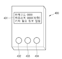
도 6은 일 실시예에 따른 제2 드론 관리기의 외형을 개략적으로 도시한 사시도이다.
도 7는 일 실시예에 따른 무인 드론의 비행 관련 정보의 제공을 도시한 화면 예시도이다.
도 8은 일 실시예에 따른 드론 관제 서버를 설명하기 위한 제어 블록도이다.
도 9 및 도 10은 일 실시예에 따른 드론 관제 서버의 위험 관리 방법을 구체적으로 설명하기 위한 도면이다.
도 11은 비행 허용 구역에 설치된 센서부를 예시하는 도면이다. 1 is a schematic diagram of a drones management system according to one embodiment.
2 is a diagram for explaining a schematic concept of a flight permission zone and a flight control.
3 is a control block diagram illustrating a first dronemanager according to an embodiment.
4 is a diagram for explaining the operation of the first dronemanager according to an embodiment.
5 is a control block diagram for explaining a second dronemanager according to an embodiment.
6 is a perspective view schematically showing the outline of a second dronemanager according to an embodiment.
FIG. 7 is a view illustrating a screen for providing flight-related information of an unmanned drones according to an exemplary embodiment of the present invention.
8 is a control block diagram for explaining a drone control server according to an embodiment.
FIG. 9 and FIG. 10 are views for explaining a risk management method of a drone control server according to an embodiment in detail.
FIG. 11 is a view illustrating a sensor unit installed in a flight-allowed zone. FIG.
본 발명의 이점 및 특징, 그리고 그것들을 달성하는 방법은 첨부되는 도면과 함께 후술되어 있는 실시예들을 참조하면 명확해질 것이다. 그러나 본 발명은 이하에서 개시되는 실시예들에 한정되는 것이 아니라 서로 다른 다양한 형태로 구현될 수 있으며, 단지 본 실시예들은 본 발명의 개시가 완전하도록 하고, 본 발명이 속하는 기술분야에서 통상의 지식을 가진 자에게 발명의 범주를 완전하게 알려주기 위해 제공되는 것이며, 본 발명은 청구항의 범주에 의해 정의될 뿐이다.Brief Description of the Drawings The advantages and features of the present invention, and how to accomplish them, will become apparent with reference to the embodiments described hereinafter with reference to the accompanying drawings. The present invention may, however, be embodied in many different forms and should not be construed as limited to the embodiments set forth herein. Rather, these embodiments are provided so that this disclosure will be thorough and complete, and will fully convey the scope of the invention to those skilled in the art. To fully disclose the scope of the invention to those skilled in the art, and the invention is only defined by the scope of the claims.
본 발명에서 사용되는 용어는 본 발명에서의 기능을 고려하면서 가능한 현재 널리 사용되는 일반적인 용어들을 선택하였으나, 이는 당 분야에 종사하는 기술자의 의도 또는 판례, 새로운 기술의 출현 등에 따라 달라질 수 있다. 또한, 특정한 경우는 출원인이 임의로 선정한 용어도 있으며, 이 경우 해당되는 발명의 설명 부분에서 상세히 그 의미를 기재할 것이다. 따라서 본 발명에서 사용되는 용어는 단순한 용어의 명칭이 아닌, 그 용어가 가지는 의미와 본 발명의 전반에 걸친 내용을 토대로 정의되어야 한다. 이하, 도면을 참조하여 본 발명에 대하여 구체적으로 설명한다.While the present invention has been described in connection with what is presently considered to be the most practical and preferred embodiment, it is to be understood that the invention is not limited to the disclosed embodiments. Also, in certain cases, there may be a term selected arbitrarily by the applicant, in which case the meaning thereof will be described in detail in the description of the corresponding invention. Therefore, the term used in the present invention should be defined based on the meaning of the term, not on the name of a simple term, but on the entire contents of the present invention. Hereinafter, the present invention will be described in detail with reference to the drawings.
도 1은 일 실시예에 따른 드론 관리 시스템을 개략적으로 도시한 도면이고, 도 2는 비행 허용 구역 및 비행 관제의 개략적인 개념을 설명하기 위한 도면이다.FIG. 1 is a schematic view of a drones management system according to an embodiment, and FIG. 2 is a diagram for explaining a schematic concept of a flight permission zone and a flight control.
무인 드론(100)은 도 1에 도시된 것과 같이 무인 드론(100)은 조작하기 위한 조작기(200)와 통신하여, 조작기(200)의 제어에 따라 비행한다. 이를 위해 무인 드론(100)과 조작기(200)는 비접촉식 통신 방법을 통해 통신할 수 있다. As shown in FIG. 1, the
구체적으로, 무인 드론(100)과 조작기(200)의 근거리 통신 방법, 예컨대, 라디오 주파수를 이용한 통신, 블루투스(Bluetooth™), WLAN(Wireless LAN), RFID(Radio Frequency Identification), 적외선 통신(Infrared Data Association; IrDA), UWB(Ultra Wideband), ZigBee, NFC(Near Field Communication), Wi-Fi(Wireless-Fidelity), Wi-Fi Direct, Wireless USB(Wireless Universal Serial Bus) 기술 중 적어도 하나를 이용할 수 있다. More specifically, the short distance communication method of the
또한, 무인 드론(100)과 조작기(200)는 장거리 통신 방법 또는 이동 통신 방법, 예컨대, LTE(Long Term Evolution), LTE-A(Long Term Evolution-Advanced) 기술 중 적어도 하나를 이용할 수 있다. The
나아가, 무인 드론(100)과 조작기(200)는 장래의 통신 기술의 발달 또는 통신 프로토콜로 지정되는 통신 방법에 따라 통신할 수 있으며, 필요한 경우 무인 드론(100)과 조작기(200)는 복수의 통신 방법을 이용하여 통신할 수 있다. Further, the
즉, 무인 드론(100)은 조작기(200)의 제어에 따라 이착륙하거나 비행할 수 있으며, 조작기(200)의 제어에 따라 영상을 촬영하거나, 촬영한 영상을 조작기(200) 또는 제2 드론 관리기(400)로 전송할 수 있다.That is, the
드론 관리 시스템은 조작기(200)의 제어에 따라 비행하는 적어도 하나의 무인 드론(100)을 비행 정보를 수집하여 무인 드론(100)의 비행을 관리하고, 무인 드론(100)의 비행과 관련된 각종 정보를 사용자에게 제공할 수 있다. The drones management system manages the flight of the
이를 위해, 일 실시예에 따른 드론 관리 시스템은 도 1에 도시된 것과 같이, 무인 드론(100)에 마련되는 제1 드론 관리기(300), 조작기(200)에 마련되는 제2 드론 관리기(400), 드론 관제 서버(500)를 포함할 수 있다. To this end, the drones management system according to an embodiment includes a
도 1에는 조작기(200)와 제2 드론 관리기(400)가 별도의 구성요소로 도시되었지만 이에 한정되지 않으며, 조작기(200)가 1, the
제1 드론 관리기(300)는 도 1에 도시된 것과 같이 무인 드론(100)에 마련되어, 무인 드론(100)의 위치를 검출하고, 미리 설정된 통신 프로토콜을 통해 이를 드론 관제 서버(500) 또는 제2 드론 관리기(400)로 전송할 수 있다. The
또한, 제1 드론 관리기(300)는 드론의 이상 상태를 빛 또는 소리로 알리기 위한 장치를 더 구비할 수 있으며, 드론 관제 서버(500), 또는 제2 드론 관리기(400)을 통해 무인 드론(100)의 비행을 제어하기 위한 장치를 더 구비할 수도 있다. The
제2 드론 관리기(400)은 도 1에 도시된 것과 같이 조작기(200)에 부착될 수 있는 형태로 마련되어, 드론 관제 서버(500)와 통신하여 무인 드론(100)과 관련된 각종 정보를 사용자에게 표시하거나, 사용자 입력에 따라 무인 드론(100)에 대한 상태를 드론 관제 서버(500)에 전송할 수 있다.The
또한, 제2 드론 관리기(400)은 무인 드론(100)의 비행과 관련된 비행 정보를 드론 관제 서버(500)로부터 수신하고, 이를 표시할 수 있다. In addition, the
또한, 제2 드론 관리기(400)는 위급 상황을 알리기 위한 입력 장치 등을 구비하여, 무인 드론(100)의 비행시 발생할 수 있는 여러가지 위험을 드론 관제 서버(500)에 전송하거나, 외부에 위험 상황을 표시할 수 있다.The
드론 관제 서버(500)는 복수의 무인 드론(100)의 비행을 관제하고, 각 무인 드론(100)의 비행 정보를 각 제2 드론 관리기(400)에 전송할 수 있다. 드론 관제 서버(500)는 무인 드론(100)의 비행 관제를 위하여 소정의 비행 허용 구역을 설정할 수 있다. The
비행 허용 구역은 무인 드론(100)의 비행이 허용되는 구역을 의미하는 것으로, 비행 허용 구역은 도 2에 도시된 것과 같이 3차원으로 설정될 수 있다. 비행 허용 구역은 드론 관제 서버(500)의 관리자에 의하여 임의로 설정될 수 있으나, 필요에 따라 관련 법규 또는 허가에 기초하여 설정될 수 있다. The flight permission zone means an area in which the flight of the
이러한 비행 허용 구역은 GPS에 따른 위치정보로 그 허용 구역의 한계 좌표가 설정될 수 있으며, 후술하겠지만 비컨(beacon) 등의 위치좌표를 확인하기 위한 센서가 설치되어 비행 허용 구역의 경계가 설정될 수 있음은 물론이다.Such a flight permission zone can be set to the limit coordinates of the allowable zone as positional information according to the GPS, and a sensor for confirming the coordinates of the beacon and the like, which will be described later, Of course it is.
즉, 드론 관제 서버(500)는 도 2에 도시된 것과 같이 비행 허용 구역을 비행하는 복수의 무인 드론(101 내지 103)의 비행 정보를 관리하고, 복수의 무인 드론(100)의 비행 정보에 기초하여 각 무인 드론(100)의 비행을 제어하거나, 각 무인 드론(100)의 제2 드론 관리기(400)로 위험 상황에 대한 정보를 제공하여 무인 드론(100) 비행으로 발생할 수 있는 사고의 위험을 최소화할 수 있다.That is, as shown in FIG. 2, the
드론 관제 서버(500)에 의하여 관리되는 위험은 비행 허용 구역 이탈, 무인 드론(100) 간 충돌, 무인 드론(100)의 오작동 중 하나일 수 있으나, 이에 한정되는 것은 아니다. The risk managed by the drones control
한편, 도 1에 도시된 것과 같이 드론 관리 시스템은 사용자 단말(600)을 더 포함할 수 있다. 사용자 단말(600)은 드론 관리기(300, 400), 드론 관제 서버(500)의 통신을 중재할 수 있다. 드론 관리기(300, 400)가 드론 관제 서버(500)와 직접적으로 통신할 수 없거나, 통신 장애가 발생한 경우 사용자 단말(600)에 의하여 드론 관제 서버(500)와 드론 관리기(300, 400)의 정보 송수신이 중재될 수 있다. Meanwhile, as shown in FIG. 1, the drones management system may further include a
또한, 사용자 단말(600)은 제2 드론 관리기(400)의 보조 장치로 동작할 수 있다. 구체적으로, 사용자 단말(600)은 제2 드론 관리기(400)와 함께 비행과 관련된 각종 정보를 표시하거나, 무인 드론(100)의 비행과 관련된 다양한 정보를 입력 받아 드론 관제 서버(500)로 전송할 수 있다. In addition, the
이때, 제2 드론 관리기(400)와 사용자 단말(600)을 통해 제공되는 비행 정보는 서로 상이할 수 있다. 예컨대, 제2 드론 관리기(400)은 주요한 비행 정보 또는 위험 정보가 표시하고, 사용자 단말(600)는 제2 드론 관리기(400)보다 더 상세한 비행 정보, 예컨대, 주변을 비행하는 주변 드론 정보 등을 표시할 수 있다. At this time, the flight information provided through the
아울러, 도 1에는 제2 드론 관리기(400)과 사용자 단말(600)이 각각 별도로 마련된 것으로 도시되어 있으나 이는 예시에 지나지 않으며, 사용자 단말(600)이 조작기(200) 및/또는 제2 드론 관리기(400)의 동작을 모두 수행함으로써 실질적으로 조작기(200) 및/또는 제2 드론 관리기(400)로 동작할 수 있음은 물론이다. 1 illustrates that the
이하 도면을 참조하여, 드론 관리 시스템의 각 구성에 대하여 더 구체적으로 설명한다. Hereinafter, each configuration of the drones management system will be described in more detail with reference to the drawings.
도 3은 일 실시예에 따른 제1 드론 관리기(300)를 설명하기 위한 제어 블록도이다. 3 is a control block diagram for explaining the
도 4는 일실시예에 따른 제1 드론 관리기의 동작을 설명하기 위한 도면이다. 4 is a diagram for explaining the operation of the first dronemanager according to an embodiment.
도 3 및 도 4를 참조하면, 일 실시예에 따른 제1 드론 관리기(300)는 제1 통신부(310), 위치 검출부(320), 경고 출력부(330), 제1 제어부(340), 전원부(350)를 포함할 수 있다. 3 and 4, the
제1 통신부(310)는 소정의 통신 프로토콜을 이용하여 드론 관제 서버(500) 또는 제2 드론 관리기(400)과 통신할 수 있다. 구체적으로, 제1 통신부(310)는 상술한 근거리 통신 방법, 장거리 통신 방법 또는 이동 통신 방법을 이용하여 드론 관제 서버(500), 제2 드론 관리기(400), 및/또는 도 10의 센서부(900)와 통신할 수 있으나, 이에 한정되는 것은 아니다. 예컨대, 제1 통신부(310)는 종래의 소정의 비행체와 통신하기 위해 사용되는 통신 방법 및 추후 기술의 발전으로 개발된 통신 방법을 통해 드론 관제 서버(500), 제2 드론 관리기(400), 센서부(900)와 통신할 수 있다.The
또한, 제1 통신부(310)는 제2 드론 관리기(400), 드론 관제 서버(500), 및/또는 센서부(900)와 통신에 각각 다른 통신 프로토콜을 이용할 수도 있다. 예컨대, 제1 통신부(310)는 드론 관제 서버(500)와는 이동 통신 방법을 이용하여 통신하고, 제2 드론 관리기(400)과는 근거리 통신 방법을 이용하여 통신하고, 센서부(900)와는 근거리 통신 방법을 이용하여 통신할 수 있다, The
또한, 제1 통신부(310)는 도 1에 도시된 것과 같이 드론 관제 서버(500)와 직접적으로 통신할 수도 있으나, 필요에 따라 제2 드론 관리기(400)과 통신하고, 제2 드론 관리기(400)의 중계에 의하여 드론 관제 서버(500)와 통신할 수 있다. 1, the
위치 검출부(320)는 무인 드론(100)의 위치를 검출한다. 구체적으로, 위치 검출부(320)는 무인 드론(100)의 비행 좌표, 또는 비행 고도를 검출할 수 있다. The
위치 검출부(320)는 무인 드론(100)의 위치 검출을 위하여 위성항법장치(GPS), 고도 센서 중 적어도 하나를 포함하여 무인 드론(100)의 위치를 검출할 수 있다. 도 10의 센서부(900)와의 통신을 통해 무인 드론(100)의 위치를 검출할 수도 있다. 검출된 무인 드론(100)의 위치 정보는 제1 통신부(310)를 통해 제2 드론 관리기(400) 또는 드론 관제 서버(500)로 전송될 수 있다. The
다른 실시예로, 위치 검출부(320)는 복수의 이동 통신 기지국과의 통신을 통하거나, 도 10의 센서부(900)와의 통신을 통해 무인 드론(100)의 위치를 검출할 수 있다. 구체적으로, 위치 검출부(320)는 복수의 이동 통신 기지국이나 센서부(900)와 통신하여, 각 이동 통신 기지국이나 센서부(900)로부터 무인 드론(100) 사이의 거리를 산출하고, 이동 통신 기지국이나 센서부(900)와 무인 드론(100) 사이의 거리에 기초하여 삼각 측량 방법으로 무인 드론(100)의 위치를 검출할 수 있다. In another embodiment, the
경고 출력부(330)는 무인 드론(100)의 위험 상황에 대한 경고를 출력할 수 있다. 이를 위해 경고 출력부(330)는 위험 상황을 외부로 표시하기 위한 LED 등과 같은 발광 수단 또는 위험 상황에 대한 경고를 제공하기 위한 스피커 등의 소리 출력 수단을 포함할 수 있다.The
즉, 경고 출력부(330)은 빛 또는 소리를 발생시켜 무인 드론(100)의 비행 허용 구역 이탈, 무인 드론(100) 간 충돌, 무인 드론(100)의 오작동 등의 위험을 외부에 경고할 수 있다. That is, the
제1 제어부(340)는 제1 드론 관리기(300)의 동작을 전반적으로 관리할 수 있다. 이를 위해, 제1 제어부(340)는 CPU, Micro-CPU 등과 같은 정보 처리 장치를 포함할 수 있으며, 장치의 구동에 필요한 데이터를 저장하기 위한 RAM, ROM 등과 같은 저장 장치를 포함할 수 있다.The
구체적으로, 제1 제어부(340)는 위치 검출부(320)에서 검출된 위치 정보가 전송되도록 제1 통신부(310)를 제어할 수 있으며, 제1 통신부(310)를 통해 전송된 위험 정보에 따라 위험에 대한 경고가 제공되도록 경고 출력부(330)를 제어할 수 있다.The
또한, 제1 제어부(340)는 무인 드론(100)의 각 구성, 예컨대, 모터를 제어하여 무인 드론(100)의 비행을 제어할 수 있으며, 비행 허용 구역 이탈, 무인 드론(100) 간 충돌, 무인 드론(100)의 오작동의 경우 비행 허용 구역을 이탈하지 않게 하거나 무인 드론이 서로 충돌하지 않도록 해당 무인 드론(100)의 비행을 자동으로 제어할 수 있다.The
전원부(350)는 제1 드론 관리기(300)의 구동 전원을 제공할 수 있다. 이를 위해, 전원부(350)는 별도의 배터리를 더 포함할 수 있으며, 경우에 따라 무인 드론(100)의 전원을 공급하는 전원 장치와 연결되어 무인 드론(100)의 전원으로부터 구동 전원을 제공 받을 수 있다. The
한편, 제1 드론 관리기(300)는 무인 드론(100)의 안전 낙하를 위한 안전 낙하기를 더 포함할 수 있다. 무인 드론(100)의 고장, 제어 이탈 또는 제어 불능으로 인하여 무인 드론(100)이 지상으로 자유 낙하하는 경우 무인 드론(100)이 파괴될 수 있으며, 무인 드론(100)의 낙하로 인한 2차 사고가 발생할 위험이 있다. Meanwhile, the
안전 낙하기는 상술한 것과 같이 무인 드론(100)이 낙하하는 경우에 동작하여 무인 드론(100)이 안전하게 낙하하도록 지원할 수 있다. The safe fall can be operated in the case where the
구체적으로, 안전 낙하기는 제2 드론 관리기(400) 또는 드론 관제 서버(500)의 제어 신호에 따라 동작하거나, 제1 제어부(340)의 제어에 따라 동작하여 무인 드론(100)의 자유 낙하 속도를 감소시킨다. Specifically, the safety dropout may be operated according to control signals of the
일례로, 안전 낙하기는 도 3에 도시된 것과 같이 제1 드론 관리기(300)의 외형을 이루는 커버(361)와 낙하시 동작하는 낙하선(362)을 포함할 수 있다. 구체적으로, 무인 드론(100)이 자유 낙하하면, 제어 신호에 의하여 커버(361)가 탈거되고, 커버(361) 내부에 마련된 낙하선(362)이 동작하여 무인 드론(100)의 자유 낙하 속도를 줄이게 된다. 이와 같이 무인 드론(100)의 자유 낙하를 방지함으로써, 무인 드론(100)의 파손을 미연에 방지하고 낙하 사고로 인한 2차 사고를 예방할 수 있다.For example, the safety dropout may include a
도 5는 일 실시예에 따른 제2 드론 관리기(400)을 설명하기 위한 제어 블록도이고, 도6은 일 실시예에 일 실시예에 따른 제2 드론 관리기의 외형을 개략적으로 도시한 사시도이다. 도 7은 도 7는 일 실시예에 따른 무인 드론의 비행 관련 정보의 제공을 도시한 화면 예시도이다. FIG. 5 is a control block diagram for explaining a
도 5 및 도 6을 참조하면, 제2 드론 관리기(400)은 제2 통신부(410), 저장부(420), 입출력부(430), 제2 제어부(440)를 포함할 수 있다. 5 and 6, the
제2 통신부(410)는 소정의 통신 프로토콜을 이용하여 제1 드론 관리기(300), 드론 관제 서버(500), 또는 도 10의 센서부(900)와 통신할 수 있다. 구체적으로, 제2 통신부(410)는 상술한 근거리 통신 방법, 장거리 통신 방법 또는 이동 통신 방법을 이용하여 제1 드론 관리기(300), 드론 관제 서버(500), 및/또는 센서부(900)와 통신할 수 있으나, 이에 한정되는 것은 아니다. 예컨대, 제2 통신부(410)는 종래 또는 추후 기술의 발전으로 개발된 통신 방법을 통해 제1 드론 관리기(300) 또는 드론 관제 서버(500)와 통신할 수 있다. The
또한, 제2 통신부(410)는 복수의 통신 방법을 통해 외부와 통신할 수 있으며, 필요에 따라 제1 드론 관리기(300), 드론 관제 서버(500), 및/또는 센서부(900)와의 통신 방법을 각각 상이하게 선택할 수도 있다. The
아울러, 제2 통신부(410)는 필요에 따라 제1 드론 관리기(300)에서 전송된 데이터를 드론 관제 서버(500)로 전송하고, 드론 관제 서버(500)에서 전송된 데이터를 제1 드론 관리기(300)로 전송할 수도 있다. The
저장부(420)는 제2 드론 관리기(400)의 구동에 필요한 각종 데이터를 저장할 수 있다. 예컨대, 저장부(420)는 제2 드론 관리기(400)의 구동을 위해 필요한 운영체제 또는 무인 드론(100)의 비행 관제를 위해 필요한 어플리케이션을 저장할 수 있으며, 무인 드론(100)의 비행 관제에서 발생하는 소정의 데이터를 저장할 수도 있다. The
입출력부(430)는 무인 드론(100)의 비행과 관련된 비행 정보를 제공할 수 있다. 무인 드론(100)의 비행 정보는 무인 드론(100)의 위치 정보, 다른 무인 드론(100)의 위치 정보, 및 비행 허용 구역 중 적어도 하나를 포함하는 것으로, 무인 드론(100)의 비행 정보는 도 6에 표시 수단(431)을 통해 제공될 수 있다. 여기서 표시 수단은 디스플레이 패널(Plasma Display Panel, PDP), 액정 디스플레이(Liquid Crystal Display: LCD) 패널, 발광 다이오드(Light Emitting Diode: LED) 패널, 또는 유기 발광 다이오드(Organic Light Emitting Diode: OLED) 패널, 능동형 유기 발광 다이오드(Active-matrix Organic Light-Emitting Diode, AMOLED) 패널 등과 같은 장치 중 하나일 수 있으나 이에 한정되는 것은 아니다.The input /
구체적으로, 표시 수단(431)을 통해 현재 고도, 비행 허용 구역의 경계와의 거리 및 방향, 주변의 위험 상황, 또는 주변을 비행하는 무인 드론의 위치 등과 같은 비행 정보가 제공될 수 있으나, 표시 수단(431)을 통해 제공되는 비행 정보가 이에 한정되는 것은 아니다. 예컨대, 도 7에 도시된 것과 같이 다른 무인 드론(100)의 위치를 표시한 평면도(601), 또는 단면도(602) 등의 형식으로 표시할 수 있다.Specifically, flight information such as the current altitude, the distance and direction with respect to the boundary of the flight-allowed zone, the surrounding dangerous situation, or the location of the unmanned drones flying around can be provided through the display means 431, The flight information provided through the
이와 같이 비행 허용 구역과 무인 드론(100)의 위치를 함께 표시함으로써, 무인 드론(100)과 비행 허용 구역 사이의 상대 위치를 제공하여 사용자의 비행 제어에 가이드를 제공할 수 있다.By displaying the positions of the
또한, 무인 드론(100)의 위치와 다른 무인 드론(100)의 위치를 동시에 표시함으로써, 다른 무인 드론(100)과의 충돌 위험을 최소화할 수 있다. In addition, by simultaneously displaying the position of the
또한, 입출력부(430)는 사용자로부터 비행과 관련된 정보를 입력 받을 수 있다. 이를 위해, 입출력부(430)는 키패드, 푸시 버튼(push button), 또는 멤브레인 버튼(membrane button)등과 같은 버튼 입력 수단, 터치 패드(touch pad) 등과 같은 터치 입력 수단을 포함할 수 있다.Also, the input /
예컨대, 입출력부(430)는 도 6에 도시된 것과 같이 외부의 위험 상황을 경고하기 위한 경고 출력부(330)를 동작시키기 위한 제1 버튼(432), 무인 드론(100)에 발생한 위험 상황에 대응되는 응급 신호를 드론 관제 서버(500)에 전송하기 위한 제2 버튼(433), 이하에서 설명할 페트롤 드론에 도움을 요청하기 위한 신호를 전송하는 제3 버튼(434)을 포함할 수 있다. For example, as shown in FIG. 6, the input /
한편, 도면에 도시되지는 않았지만 제2 드론 관리기(400)가 조작기(200)에 마련될 수 있으므로, 제2 드론 관리기(400)의 입출력부(430)는 사용자가 무인 드론(100)의 각종 비행을 조작하기 위한 조작 인터페이스를 구비할 수도 있음은 물론이다.The input /
제2 제어부(440)는 제2 드론 관리기(400)의 전반적인 구성을 제어한다. 구체적으로, 제2 제어부(440)는 제2 통신부(410)를 통해 수신된 비행 정보가 표시되도록 입출력부(430)를 제어하거나, 입출력부(430)를 통해 사용자가 위험 상황을 입력하면, 이에 대한 정보가 드론 관제 서버(500)에 전송되도록 제2 통신부(410)를 제어할 수 있다. The
또한, 제2 제어부(440)는 비행 허용 구역 이탈, 무인 드론(100) 간 충돌, 무인 드론(100)의 오작동이 감지된 경우 비행 허용 구역을 이탈하지 않게 하거나 무인 드론이 서로 충돌하지 않도록 해당 무인 드론(100)의 비행을 자동으로 제어할 수도 있다.The
한편, 도 1과 같이 사용자 단말(600)이 더 포함되는 경우, 비행 정보는 사용자 단말(600)과 표시 수단(431)에 모두 표시될 수 있다. 이때, 사용자 단말(600)에 표시되는 비행 정보와 표시 수단(431)에 표시되는 비행 정보를 서로 상이할 수 있다.1, the flight information may be displayed in both the
일 실시예로, 표시 수단(431)을 통해서는 비행고도, 위험 상황 정보, 비행 허용 구역의 경계와의 거리 및 방향 등의 주요 정보가 표시되고, 사용자 단말(600)을 통해서 다른 무인 드론(100)의 위치를 표시한 평면도(601), 또는 단면도(602) 등과 같은 부가 정보가 표시될 수 있다. The main information such as the flying height, the dangerous situation information, the distance and the direction to the boundary of the flight allowable zone, and the like are displayed through the display means 431, and the other
또한, 사용자 단말(600)에는 사용자로부터 위험 상황에 대한 입력을 제공 받기 위한 응급 상황 아이콘(603)이 추가로 제공될 수도 있다.In addition, the
한편, 도 5 내지 도 7에서 제2 드론 관리기(400)에 대해 설명되었는데, 제2 드론 관리기(400)의 기능은 전술한 조작기(200)에 포함되거나 사용자 단말(600)에 포함되어 구현될 수도 있음은 물론이다. 5 to 7, the functions of the
도 8은 일 실시예에 따른 드론 관제 서버(500)를 설명하기 위한 제어 블록도이고, 도 9 및 도 10은 일 실시예에 따른 드론 관제 서버(500)의 위험 관리 방법을 구체적으로 설명하기 위한 도면이다. FIG. 8 is a control block diagram for explaining a
도 8을 참조하면, 일 실시예에 따른 드론 관제 서버(500)는 서버 통신부(510), 비행 정보 관리부(520), 위험 관리부(530), 페트롤 관리부(540)를 포함할 수 있다. Referring to FIG. 8, the drones control
서버 통신부(510)는 소정의 통신 프로토콜을 이용하여 제1 드론 관리기(300), 제2 드론 관리기(400) 및/또는 도 10의 센서부(900)와 통신할 수 있다. 구체적으로, 서버 통신부(510)는 상술한 근거리 통신 방법, 장거리 통신 방법 또는 이동 통신 방법을 이용하여 제1 드론 관리기(300), 제2 드론 관리기(400) 및/또는 또는 센서부(900)와 통신할 수 있으나, 이에 한정되는 것은 아니다. 예컨대, 제2 통신부(410)는 종래 또는 추후 기술의 발전으로 개발된 통신 방법을 통해 제1 드론 관리기(300), 드론 관제 서버(500) 및/또는 센서부(900)와 통신할 수 있다. The
또한, 서버 통신부(510)는 복수의 통신 방법을 통해 외부와 통신할 수 있으며, 필요에 따라 제1 드론 관리기(300), 제2 드론 관리기(400) 및/또는 센서부(900)와의 통신 방법을 각각 상이하게 선택할 수도 있다. 예컨대, 제1 드론 관리기(300) 및 센서부(900)와는 유무선 인터넷 또는 장거리 통신 방법을 통해 통신하고, 제2 드론 관리기(400)과는 이동 통신 방법을 통해 통신할 수 있다. The
또한, 도 1에 도시된 것과 같이 사용자 단말(600)이 마련된 경우 서버 통신부(510)는 사용자 단말을 통해 통신할 수 있으며, 필요에 따라 사용자 단말(600)의 통신 중개에 따라 드론 관리기(300,400)와 통신할 수도 있다.1, when the
비행 정보 관리부(520)는 무인 드론(100)의 비행을 모니터링할 수 있다. 비행 정보 관리부(520)는 제1 드론 관리기(300)에서 검출된 위치 정보에 기초하여 복수의 무인 드론(100)의 위치 정보를 관리할 수 있다. 이때, 무인 드론(100)의 위치 정보는 상술한 것과 같이 제1 드론 관리기(300)를 통해 직접 전송되거나, 제2 드론 관리기(400)의 중계에 의하여 전송될 것일 수 있다. The flight information management unit 520 may monitor the flight of the
구체적으로, 비행 정보 관리부(520)는 제1 드론 관리기(300)에서 전송된 고도와 좌표에 기초하여 각 무인 드론(100)의 비행 위치를 산출하여 관리한다. 또한, 비행 정보 관리부(520)는 각 무인 드론(100)과 비행 허용 구역의 경계와의 상대 거리 각 무인 드론(100) 간의 상대 거리를 산출하여 관리할 수도 있다.Specifically, the flight information management unit 520 calculates and manages the flight position of each
이와 같이 생성된 비행 정보는 제2 드론 관리기(400)로 전송된다. 구체적으로, 비행 정보 관리부(520)는 무인 드론(100)의 위치, 비행 허용 구역, 및 주변 드론 정보를 비행 정보로 제2 드론 관리기(400)로 전송할 수 있다. 이때, 주변 드론 정보는 무인 드론(100)과 미리 설정된 거리 이내를 비행하는 무인 드론(100)의 위치 정보를 의미하는 것으로, 비행 정보 관리부(520)는 무인 드론(100)과 미리 설정된 거리 이내를 비행하는 드론을 주변 드론으로 탐색하고, 주변 드론에 대한 위치 정보를 이용하여 주변 드론 정보를 생성할 수 있다. The flight information thus generated is transmitted to the
이와 같이 제2 드론 관리기(400)로 전송된 비행 정보는 도 6 또는 도 7에 도시된 것과 같이 표시될 수 있다. 즉, 비행 정보에 따라 제2 드론 관리기(400) 및/또는 사용자 단말(600)은 무인 드론(100)과 비행 허용 구역의 상대 위치, 무인 드론(100)과 주변 드론의 상대 위치를 표시할 수 있다. Thus, the flight information transmitted to the
위험 관리부(530)는 비행 정보에 기초하여 위험 상황 발생을 예측할 수 있다. 상술한 것과 같이 사용자가 응급 상황 아이콘(603)을 입력하면, 제2 드론 관리기(400)로부터 응급 상황이 푸쉬된다. 위험 관리부(530)는 응급 상황이 푸쉬되면 무인 드론과 일정한 거리에 있는 주변 무인 드론을 탐색하고, 탐색된 주변 무인 드론에게 위험 상황 발생을 푸쉬할 수 있다. The
또한, 위험 관리부(530)는 복수의 무인 드론(100)에 대한 비행 정보에 기초하여 각 무인 드론(100)의 위험 상황 발생을 감지하고, 위험 상황이 발생하는 경우 제2 드론 관리기(400) 또는 제1 드론 관리기(300)의 경고 출력부(330)를 제어하여 위험 상황에 대하여 경고할 수 있다. The
구체적으로, 위험 관리부(530)는 이탈 관리부(531), 충돌 관리부(532), 및 오작동 관리부(533)중 적어도 하나를 포함할 수 있다. Specifically, the
이탈 관리부(531)는 무인 드론(100)의 비행 허용 구역 이탈 위험을 관리하고, 이에 대한 경고를 제공할 수 있다. 구체적으로, 이탈 관리부(531)는 무인 드론(100)의 위치 정보에 기초하여 무인 드론(100)의 비행 허용 구역 이탈 가능성을 산출하고, 비행 허용 구역 이탈 가능성에 기초하여 경고를 제공할 수 있다. The
일례로, 도 9에 도시된 것과 같이 무인 드론(100)의 위치와 비행 허용 구역의 거리가 미리 설정된 임계 거리(D2) 이하이면, 비행 허용 구역 이탈 가능성이 높은 것으로 판단하여 제2 드론 관리기(400) 또는 제1 드론 관리기(300)에 이탈 경고를 푸쉬할 수 있다. 9, if the distance between the position of the
한편, 이탈 관리부(531)는 무인 드론(100)의 현재 위치뿐만 아니라, 위치 정보의 변화에 기초하여 비행 허용 구역 이탈 가능성을 산출할 수도 있다. 예컨대, 무인 드론(100)과 비행 허용 구역의 거리가 미리 설정된 기준치 이상의 속도로 가까워지는 경우에는 무인 드론(100)과 비행 허용 구역의 거리가 임계 거리(D2) 이상이라도 이탈 가능성이 높은 것으로 판단하여 이탈 경고를 푸시할 수 있다. 반대로, 무인 드론(100)과 비행 허용 구역의 거리가 미리 설정된 임계 거리(D2) 이하라도 무인 드론(100)과 비행 허용 구역의 거리가 미리 설정된 기준치 이상의 속도로 멀어지는 경우 이탈 가능성이 높은 것으로 판단하여 이탈 경고를 푸쉬하지 않을 수 있다. On the other hand, the
충돌 관리부(532)는 무인 드론(100) 간의 충돌 가능성을 관리하고, 이에 대한 경고를 제공할 수 있다. 구체적으로, 충돌 관리부(532)는 복수의 무인 드론(100)의 위치 정보에 기초하여 무인 드론(100) 간 충돌 가능성을 산출하고, 충돌 가능성에 기초하여 충돌 경고를 제공할 수 있다. The
일례로, 충돌 관리부(532)는 도 10에 도시된 것과 같이 무인 드론(100)과 미리 설정된 거리 이내를 비행하는 주변 무인 드론(100)을 탐색하여 주변 드론 정보를 생성하고, 주변 무인 드론(100)과 무인 드론(100)의 거리가 미리 설정된 위험 거리(D1)보다 좁아지면, 충돌 가능성이 높은 것으로 판단하여, 제2 드론 관리기(400) 또는 제1 드론 관리기(300)에 충돌 경고를 푸쉬할 수 있다. 이때, 충동 관리부는 충돌 위험이 있는 주변 드론(101)에 대응되는 제2 드론 관리기(400)에게도 충돌 경고를 푸쉬할 수 있다.10, the
오작동 관리부(533)는 무인 드론(100)의 오작동을 감지하고, 오작동이 감지되면 오작동 경보를 제2 드론 관리기(400) 또는 제1 드론 관리기(300)에 전송할 수 있다. 일반적으로, 무인 드론(100)은 사용자의 조작을 통해 비행 가능한 비행 궤적이 존재하므로, 오작동 관리부(533)는 무인 드론(100)의 위치 정보의 변화에 기초하여 무인 드론(100)의 비행 궤적을 분석하고, 무인 드론(100)의 비행 궤적이 미리 설정된 정상 궤적 범위를 벗어나면 무인 드론(100)이 오작동하는 것으로 판단할 수 있다. 예컨대, 무인 드론(100)의 비행 궤적이 미리 설정된 정상 궤적의 범위를 벗어나 급격이 하강하는 경우 무인 드론(100)이 오작동하는 것으로 판단될 수 있다. The
한편, 무인 드론(100)의 비행 궤적이 조작기(200)와 통신 가능 거리를 벗어난 것으로 판단되면 미리 설정된 정상 궤적의 범위를 벗어난 것으로 판단하여 무인 드론(100)이 오작동하는 것으로 판단할 수 있다. On the other hand, if it is determined that the flight path of the
이와 같이 무인 드론(100)이 오작동하는 것으로 판단되면, 오작동 관리부(533)는 제2 드론 관리기(400)로 오작동 경보를 푸쉬할 수 있으며, 미리 설정된 거리 이내에 비행하는 주변 무인 드론(100)에 대응되는 제2 드론 관리기(400)로 오작동 경고를 푸쉬할 수도 있다. If it is determined that the
한편, 오작동 관리부(533)는 제2 드론 관리기(400)로부터 응급 상황 발생이 푸쉬되면, 무인 드론(100)과 미리 설정된 거리 이내에 있는 무인 드론을 탐색하고, 탐색된 무인 드론에 대응되는 제2 드론 관리기에 오작동 발생 경고를 푸쉬할 수 있다. If an emergency situation is pushed from the
다시 도 8을 참조하면, 위험 관리부(530)는 위험 발생이 감지되면, 이에 따라 무인 드론(100)의 비행을 제어할 수도 있다. 구체적으로, 위험 관리부(530)는 비행 관리기에 제1 제어부(340)로 위험 회피 비행을 위한 제어 신호를 송출하여 무인 드론(100)의 비행을 제어할 수 있다.Referring again to FIG. 8, the
일 실시예로, 무인 드론(100)의 비행 허용 구역 이탈 가능성이 감지되면, 위험 관리부(530)는 무인 드론(100)의 비행 방향을 비행 허용 구역과 멀어지는 방향으로 변경되게 제1 드론 관리기(300)에 비행 제어 신호를 전송하거나, 무인 드론(100)의 비행 속도가 감소되도록 제1 드론 관리기(300)에 비행 제어 신호를 전송할 수 있다. The
다른 실시예로, 무인 드론(100) 간의 충돌 가능성이 감지되는 경우, 위험 관리부(530)는 충돌 가능성이 감지됨 무인 드론(100)에 대응되는 제1 드론 관리기(300)에 비행 제어 신호를 전송하여 무인 드론(100)의 속도를 감소시키거나, 무인 드론(100)의 진행 방향을 서로 멀어지도록 할 수 있다. In another embodiment, when a possibility of collision between the
도 1에는 도시되어 있지 않지만 도 8을 참조하면, 무인 드론 관리 시스템은 페트롤 드론(700)을 더 포함할 수 있다. 페트롤 드론(700)은 비행 관리 구역을 관리하기 위한 무인 드론(100)을 의미하는 것으로, 페트롤 드론(700)은 비행하는 드론을 포획하기 위한 장치, 예를 들어, 로봇 팔 또는 그물망을 포함할 수 있다. 또한, 페트롤 드론(700)은 응급 상황을 알리기 위한 장치 및 주변의 영상을 촬영하기 위한 카메라 등을 더 포함할 수 있다. Although not shown in FIG. 1, with reference to FIG. 8, the unmanned drone management system may further include a
페트롤 드론(700)은 드론 관제 서버(500)의 페트롤 관리부(540)에 의하여 제어되어, 비행 허용 구역 및 인근 구역을 비행하는 드론을 관리할 수 있다. The
비행 허용 구역 관리의 일례로, 페트롤 관리부(540)는 페트롤 드론(700)을 제어 제2 드론 관리기(400) 또는 사용자 단말(600)을 통해 응급신호가 전송된 무인 드론이 안정하게 착륙할 수 있도록 무인 드론의 비행을 보조할 수 있다. The
구체적으로, 제2 드론 관리기(400) 또는 사용자 단말(600)를 통해 응급 신호가 수신되면, 페트롤 관리부(540)는 제2 드론 관리기(400) 또는 사용자 단말(600)에 대응되는 무인 드론을 사고 드론으로 특정하고, 사고 드론의 위치를 탐색한다. Specifically, when an emergency signal is received through the
그리고, 페트롤 관리부(540)는 사고 드론과 가장 인접한 페트롤 드론(700)을 탐색하여 사고 드론까지의 비행 경로를 설정하여, 사고 드론의 인근으로 이동하도록 페트롤 드론(700)을 제어한다. 페트롤 드론(700)이 사고 드론 인근으로 이동하면, 페트롤 관리부(540)는 사고 드론을 포획하도록 페트롤 드론(700)을 제어하여 사고 드론을 포획하고, 지상에 미리 설정된 안정 구역으로 사고 드론이 이동되도록 페트롤 드론(700)을 제어할 수 있다. Then, the
비행 허용 구역 관리의 다른례로, 페트롤 관리부(540)는 페트롤 드론(700)을 제어하여 비행 허용 구역의 이탈 가능성이 높은 무인 드론 또는 비행 허용 구역을 이탈한 무인 드론을 비행 허용 구역 내의 미리 설정된 위치로 이동시킬 수 있다. The
구체적으로, 페트롤 관리부(540)는 상술한 비행 허용 구역을 벗어나거나, 비행 허용 구역을 벗어날 가능성이 높은 무인 드론이 검출되면, 검출됨 무인 드론을 이탈 드론으로 설정하고, 이탈 드론과 가장 인접한 페트롤 드론(700)을 탐색하여 이탈 드론까지의 비행 경로를 설정하여 이탈 드론의 인근으로 이동하도록 페트롤 드론(700)을 제어한다. 페트롤 드론(700)이 이탈 드론 인근으로 이동하면, 페트롤 관리부(540)는 이탈 드론을 포획하도록 페트롤 드론(700)을 제어하여 이탈 드론을 포획하여 지상 또는 공중에 미리 설정된 안정 구역으로 이탈 드론이 이동되도록 페트롤 드론(700)을 제어할 수 있다. Specifically, the
비행 허용 구역 관리의 또 다른례로, 페트롤 관리부(540)는 제1 드론 관리기(300)를 부착하지 않은 무인 드론을 검출하고, 제1 드론 관리기(300)가 부착되지 않은 무인 드론을 포획하도록 페트롤 드론(700)을 제어할 수 있다. The
이를 위해, 페트롤 관리부(540)는 제1 드론 관리기(300)를 부착하지 않은 무허가 무인 드론을 검출할 수 있다. 무허가 무인 드론의 검출에서는 페트롤 드론(700) 또는 비행 허용 구역에 마련된 카메라가 이용될 수 있다. 구체적으로, 제2 드론 관리기(400)는 페트롤 드론(700) 또는 비행 허용 구역에 마련된 카메라에서 획득되는 적어도 하나의 영상 정보를 분석하여 비행 허용 구역을 비행하는 무인 드론들을 검출하고, 각 무인 드론과의 백터를 산출하여 비행 허용 구역을 비행하는 무인 드론의 위치가 표시된 위치맵을 생성한다. For this, the
드론 맵의 생성이 완료되면, 페트롤 관리부(540)는 제1 드론 관리기(300)를 통해 검출된 각 무인 드론의 위치와 드론 맵에 각 드론의 위치를 비교하여 제1 드론 관리기(300)가 부착되지 않은 드론을 추출하여 무허가 무인 드론을 설정한다. When the creation of the dron map is completed, the
그리고, 무허가 무인 드론과 가장 인접한 페트롤 드론(700)을 탐색하여 무허가 무인 드론까지의 비행 경로를 설정하여 무허가 무인 드론의 인근으로 이동하도록 페트롤 드론(700)을 제어한다. 페트롤 드론(700)이 무허가 무인 드론 인근으로 이동하면, 페트롤 관리부(540)는 무허가 무인 드론을 포획하도록 페트롤 드론(700)을 제어하여 무허가 무인 드론을 포획하여 지상에 미리 설정된 안정 구역으로 무허가 무인 드론이 이동되도록 페트롤 드론(700)을 제어할 수 있다. Then, the
도 11은 비행 허용 구역에 설치된 센서부를 예시하는 도면이다. FIG. 11 is a view illustrating a sensor unit installed in a flight-allowed zone. FIG.
전술한 것처럼 비행 허용 구역은 GPS에 따른 위치정보로 그 허용 구역의 한계 좌표가 설정될 수 있지만, 도 11에서처럼 BLE(bluetooth low energy)를 이용한 비컨(beacon) 및 IOT(internet of things, 사물인터넷) 센서 중의 적어도 하나를 이용한 적어도 하나 이상의 센서부(900)가 비행 허용 구역 범위 이내 또는 그 주변에 설치되어 비행 허용 구역의 경계가 설정될 수도 있다.As described above, the flight permission zone can be set to the limit coordinates of the allowable zone by location information based on the GPS, but the beacon and IOT (internet of things) using the bluetooth low energy (BLE) At least one
이러한 센서부(900)는 드론 관리 서버(500), 제1 드론 관리기(400) 및 제2 드론 관리기(600)로 센서부(900)가 설치된 지점의 기준위치정보를 제공함으로써, 각 무인 드론의 위치가 정밀하게 파악될 수 있도록 한다.The
이러한 센서부(900)는 비행 허용 구역의 주변에 하나가 설치될 수 있지만, 공간 상단이나 하단 어느 위치에도 더 추가될 수도 있고 현실 공간의 형태와 가상의 3D 맵에 따라서 다수의 센서들이 추가될 수도 있음은 물론이다. The
이러한 센서부(900)가 설치되면 각 드론(101~102)들은 자신의 위치뿐만 아니라 다른 드론의 위치도 정밀하게 파악할 수 있게 되어 비행 허용 구역의 이탈 방지나 드론 간의 충돌 방지를 더욱 효과적으로 제어할 수 있다. When the
또한 GPS를 이용하기 힘든 실내에서 센서부(900)와의 신호 교환으로 각 드론(101~102)의 위치 파악, 비행 허용 구역의 이탈 방지, 드론 간의 충돌 방지가 가능하며, 실외에 센서부(900)가 설치된 경우 더욱 정밀한 위치 파악이 가능함은 물론이다.In addition, it is possible to determine the position of each of the
드론 간의 위치 파악, 비행 허용 구역의 이탈 방지, 드론 간의 충돌 방지가 구현됨으로써, 나아가 드론을 이용한 스포츠나 드론을 활용한 게임에 폭넓게 이용될 수 있다. The position of the drones can be grasped, the departure of the flight allowable area can be prevented, and the collision between the drones can be prevented. Thus, it can be widely used for games utilizing drones.
예를 들어, 가상 현실과 접목시켜 가상 현실 공간에 이벤트 아이템을 발생시키고 발생된 이벤트 아이템을 획득하거나, 다른 드론과 가상 대결을 통하여 목적된 아이템을 획득하는 게임 등에 응용될 수 있다. 이를 위해 3D맵과 3D홀로그램의 매칭이 될 수 있도록 하며, 이외 여러가지 상황에 따른 효과나 이벤트 등을 위해 별도의 기구물이 추가 될 수도 있다. 게임이나 스포츠에 적용되는 경우, 운전 미숙으로 인하여 드론간에 서로 충돌하거나 비행 허용 구간을 이탈하거나 장애물과 충돌하는 것을 방지함으로써 원활하게 게임이나 스포츠가 진행될 수 있도록 도움을 줄 수 있다. For example, it can be applied to a game in which an event item is generated in a virtual reality space by combining with a virtual reality, a generated event item is acquired, or a game in which a target item is acquired through a virtual confrontation with another drone. In order to do this, it is necessary to match the 3D map with the 3D hologram. In addition, a separate mechanism may be added for various effects and events. When applied to a game or a sport, it can help a game or a sport to proceed smoothly by preventing the drones from colliding with each other, leaving the flight allowance zone, or colliding with an obstacle due to insufficient driving.
본원 발명의 실시예 들과 관련된 기술 분야에서 통상의 지식을 가진 자는 상기 기재의 본질적인 특성에서 벗어나지 않는 범위에서 변형된 형태로 구현될 수 있음을 이해할 수 있을 것이다. 그러므로, 개시된 방법들은 한정적인 관점이 아닌 설명적 관점에서 고려되어야 한다. 본 발명의 범위는 발명의 상세한 설명이 아닌 특허청구 범위에 나타나며, 그와 동등한 범위 내에 있는 모든 차이점은 본 발명의 범위에 포함되는 것으로 해석되어야 한다.It will be understood by those skilled in the art that various changes in form and details may be made therein without departing from the spirit and scope of the invention as defined by the appended claims. Therefore, the disclosed methods should be considered in an illustrative rather than a restrictive sense. It is intended that the present invention cover the modifications and variations of this invention provided they come within the scope of the appended claims and their equivalents.
100: 무인 드론
200: 조작기
300: 제1 드론 관리기
400: 제2 드론 관리기
500: 드론 관제 서버
600: 사용자 단말100: Uninhabited drones
200: Actuator
300: First dronemanager
400: Second drone manager
500: Dron control server
600: User terminal
Claims (12)
무인 드론에 마련되어 무인 드론의 고도와 좌표를 검출하고, 미리 설정된 통신 프로토콜에 따라 상기 검출된 고도와 좌표를 전송하는 제1 드론 관리기; 및
상기 드론 관제 서버로부터 상기 제1 관리기에서 검출된 무인 드론의 고도와 좌표에 기초하여 생성된 위치 정보와 상기 비행 허용 구역에 대한 정보를 수신하여 표시하는 제2 드론 관리기;
을 포함하는 드론 관리 시스템.
A drone control server for monitoring the flight of at least one unmanned drones by setting a flight allowance zone;
A first dronemanager provided in the unmanned dron to detect the altitude and coordinates of the unmanned drones and transmit the detected altitude and coordinates according to a preset communication protocol; And
A second dronemanager for receiving and displaying location information generated based on altitude and coordinates of the unmanned drones detected by the first manager, and information on the flying permission zone from the drones control server;
And a drones.
상기 드론 관제 서버는,
상기 위치 정보에 기초하여 무인 드론이 상기 비행 허용 구역을 이탈할 가능성을 산출하고, 산출된 가능성이 미리 설정된 임계값 이상이면 상기 제2 드론 관리기에 이탈 경고를 푸쉬하는 드론 관리 시스템.
The method according to claim 1,
The drone control server,
Calculates a possibility that the unmanned drones will leave the flight allowance zone based on the positional information, and pushes the departure warning to the second dronemanager if the calculated possibility is equal to or greater than a preset threshold value.
상기 드론 관제 서버는,
상기 무인 드론과 미리 설정된 거리 이내를 비행하는 주변 무인 드론을 탐색하여 주변 드론 정보를 생성하여 상기 제2 드론 관리기로 전송하고,
상기 제2 드론 관리기는,
상기 위치 정보 및 상기 주변 드론 정보에 기초하여 상기 무인 드론과 상기 주변 무인 드론의 상태 위치를 표시하는 드론 관리 시스템.
The method according to claim 1,
The drone control server,
Searches the peripheral unmanned drones flying within a predetermined distance from the unmanned drones to generate peripheral dron information and transmits the generated peripheral dron information to the second dronemanager,
Wherein the second dronemanager comprises:
And displays the status of the unmanned drones and the surrounding uninvited drones based on the positional information and the peripheral drone information.
상기 드론 관제 서버는,
상기 주변 무인 드론과 상기 무인 드론의 거리가 미리 설정된 위험 거리보다 좁아지면 상기 제2 드론 관리기로 충돌 경고를 푸쉬하는 드론 관리 시스템.
The method of claim 3,
The drone control server,
And pushing the collision warning to the second dronemanager if the distance between the surrounding unmanned drones and the unmanned drones becomes narrower than a preset danger distance.
상기 드론 관제 서버는,
상기 무인 드론과 미리 설정된 거리 이내에 비행하는 주변 무인 드론의 오작동이 감지되면, 상기 제2 드론 관리기로 오작동 경고를 푸쉬하는 드론 관리 시스템.
The method according to claim 1,
The drone control server,
And a malfunction warning is pushed to the second dronemanagement unit when a malfunction of the surrounding unmanned drones flying within a predetermined distance from the unmanned drones is detected.
상기 드론 관제 서버는,
상기 미리 설정된 거리 이내에 비행하는 주변 무인 드론의 비행 궤적이 미리 설정된 정상 궤적 범위를 벗어나면 상기 주변 무인 드론이 오작동하는 것으로 판단하는 드론 관리 시스템.
6. The method of claim 5,
The drone control server,
And determines that the peripheral unmanned drones malfunction if the flight trajectory of the surrounding unmanned drones flying within the predetermined distance deviates from a preset normal trajectory range.
상기 제1 드론 관리기는,
빛 또는 소리를 발생하는 상기 무인 드론의 상기 비행 허용 구역 이탈 위험, 상기 무인 드론과 주변 무인 드론의 충돌 위험, 및 상기 주변 무인 드론의 오작동 위험 중 적어도 하나의 위험에 대하여 경고를 제공하는 위험 경고부;를 더 포함하는 드론 관리 시스템.
The method according to claim 1,
Wherein the first dronemanager comprises:
A danger warning section for warning a danger of at least one of the risk of the flying of the unmanned drones emitting light or sound, the risk of collision between the unmanned drones and the surrounding unmanned drones, and the risk of malfunction of the surrounding unmanned drones, ; ≪ / RTI >
상기 제1 드론 관리기는,
상기 제2 드론 관리기 또는 상기 드론 관제 장치의 제어 신호에 따라 동작하여 상기 무인 드론의 낙하 속도를 감소시키는 안전 낙하기;를 더 포함하는 드론 관리 시스템.
The method according to claim 1,
Wherein the first dronemanager comprises:
And operating in accordance with a control signal of the second dronemanager or the dron controller to reduce the drop rate of the unmanned drones.
다른 무인 드론을 포획하기 위한 수단을 포함하여 상기 비행 허용 구역을 비행하는 드론을 관리하는 페트롤 드론;을 더 포함하고,
상기 드론 관제 서버는,
상기 제2 드론 관리기로부터 응급 신호가 입력되면, 상기 페트롤 드론이 상기 제2 드론 관리기에 대응되는 상기 제1 드론 관리기의 위치로 이동하도록 제어하고, 상기 제1 드론 관리기가 부착된 무인 드론을 포획하여 미리 설정된 안정 위치로 상기 페트롤 드론이 이동하도록 제어하는 드론 관리 시스템.
The method according to claim 1,
Further comprising: a petrol drone for managing a drones flying in the flight allowable area, including means for capturing other unmanned drone,
The drone control server,
Wherein when the emergency signal is input from the second dronemanager, the control unit controls the petrolron to move to the position of the first dronemanager corresponding to the second dronron manager, and captures the unmanned dronon attached to the first dronron manager And controls the petrol drone to move to a preset stable position.
다른 무인 드론을 포획하기 위한 수단을 포함하여 상기 비행 허용 구역을 비행하는 드론을 관리하는 페트롤 드론;을 더 포함하고,
상기 드론 관제 서버는,
무인 드론의 상기 비행 허용 구역 이탈 위험이 감지되거나, 상기 비행 허용 구역을 이탈하는 이탈 드론이 감지되면, 상기 페트롤 드론을 상기 이탈 드론에 마련되 제1 드론 관리기의 위치로 이동하도록 제어하고, 상기 제1 드론 관리기가 부착된 이탈 드론을 포획하여 미리 설정된 안정 위치로 상기 페트롤 드론이 이동하도록 제어하는 포함하는 드론 관리 시스템.
The method according to claim 1,
Further comprising: a petrol drone for managing a drones flying in the flight allowable area, including means for capturing other unmanned drone,
The drone control server,
The control unit controls the petrol drone to move to the position of the first dronemanager provided in the departing dronon if the risk of departing from the flight allowable zone of the unmanned dron is detected or when the departing dronon departing from the flight allowable zone is sensed, 1 dronemanager captures the detached dronon attached thereto and controls the movement of the petrolron to a preset stable position.
상기 비행 허용 구역에 대한 영상을 획득하는 제1 카메라;
다른 무인 드론을 포획하기 위한 수단 및 주변에 대한 영상을 획득하는 제2 카메라을 포함하여 상기 비행 허용 구역을 비행하는 드론을 관리하기 위한 페트롤 드론;을 더 포함하고,
상기 드론 관제 서버는,
제1 카메라 또는 제2 카메라를 통해 획득된 영상을 분석하여, 상기 비행 허용 구역을 비행하는 드론의 위치를 분석하여 상기 비행 허용 구역을 비행하는 드론의 위치맵을 생성하고,
상기 위치맵과 제1 드론 관리기에서 검출된 각 드론의 위치를 비교하여 제1 드론 관리기가 부착되지 않은 무허가 무인 드론을 특정하고,
상기 무허가 드론을 포획하여 상기 무허가 무인 드론이 미리 설정된 안전 위치로 이동하도록 상기 페트롤 드론을 제어하는 드론 관리 시스템.
The method according to claim 1,
A first camera for acquiring an image of the flight allowable area;
Further comprising: a petrol drone for managing a dron flying through the flight allowable area including a means for capturing another unmanned dron and a second camera for acquiring an image of the surroundings,
The drone control server,
An image obtained through the first camera or the second camera is analyzed to analyze a position of a dron flying in the flight allowable area to generate a position map of a dron flying in the flight allowable area,
Comparing the position map with the position of each of the drones detected by the first dronemanagement unit to specify an unauthorized unmanned drones to which the first dronemanagement unit is not attached,
And controlling the petrol drone to capture the unauthorized drones and move the unauthorized unmanned drones to a preset safety position.
상기 비행 허용 구역의 주변에 적어도 하나 이상 설치되고, 상기 드론 관리 서버, 제1 드론 관리기 및 제2 드론 관리기로 설치 지점에 대한 기준위치정보를 제공하는 센서부를 더 포함하는 드론 관리 시스템.
The method according to claim 1,
Further comprising a sensor unit installed at least in the periphery of the flight allowable area and providing reference position information about an installation point to the drones management server, the first drones manager and the second drones manager.
Priority Applications (1)
| Application Number | Priority Date | Filing Date | Title |
|---|---|---|---|
| KR1020170031911A KR102007471B1 (en) | 2017-03-14 | 2017-03-14 | System for managing drone |
Applications Claiming Priority (1)
| Application Number | Priority Date | Filing Date | Title |
|---|---|---|---|
| KR1020170031911A KR102007471B1 (en) | 2017-03-14 | 2017-03-14 | System for managing drone |
Publications (2)
| Publication Number | Publication Date |
|---|---|
| KR20180104956A true KR20180104956A (en) | 2018-09-27 |
| KR102007471B1 KR102007471B1 (en) | 2019-08-05 |
Family
ID=63719291
Family Applications (1)
| Application Number | Title | Priority Date | Filing Date |
|---|---|---|---|
| KR1020170031911A Expired - Fee Related KR102007471B1 (en) | 2017-03-14 | 2017-03-14 | System for managing drone |
Country Status (1)
| Country | Link |
|---|---|
| KR (1) | KR102007471B1 (en) |
Cited By (13)
| Publication number | Priority date | Publication date | Assignee | Title |
|---|---|---|---|---|
| KR102029991B1 (en) * | 2019-02-27 | 2019-11-08 | (주)텔미전자 | Method for the detecting and hunting of trespassing drone by using multi tod surround camera device |
| KR20200049158A (en) * | 2018-10-31 | 2020-05-08 | 한국항공우주연구원 | A Restricted Zone Intrusion Prevention System For Unmanned Aerial Vehicle |
| KR102182806B1 (en) * | 2020-01-15 | 2020-11-25 | 주식회사 포드론 | Method, Apparaus and System for Managing Video Photographed by Drone |
| KR102200784B1 (en) * | 2019-08-20 | 2021-01-08 | 권성주 | Drone flight test system |
| CN112513765A (en) * | 2020-02-26 | 2021-03-16 | 深圳市大疆创新科技有限公司 | Information processing method, electronic device, information processing system, and readable storage medium |
| KR20210038763A (en) * | 2019-09-30 | 2021-04-08 | (주) 성부 | Fire suppression system |
| KR20210070185A (en) * | 2019-12-04 | 2021-06-14 | 주식회사 이노드 | Apparatus for Unmanned Aerial Vehicle Control of Gimbal Structure Mountable with Cellphone and Controlling Unmanned Aerial Vehicle System Comprising the same |
| WO2021125838A1 (en) * | 2019-12-17 | 2021-06-24 | 주식회사 케이티 | Method and device for setting drone flight path |
| WO2021172762A1 (en) * | 2020-02-28 | 2021-09-02 | 임상진 | Life protection device system |
| KR102356186B1 (en) * | 2021-08-12 | 2022-02-08 | 주식회사 삼성드론 | Method and apparatus for providing swarm drone platform service using decentralized identifiers |
| WO2022119073A1 (en) * | 2020-12-04 | 2022-06-09 | 한국전자기술연구원 | Mobile communication network-based management system for remote mission operation using unmanned vehicles |
| KR20220080526A (en) * | 2020-12-07 | 2022-06-14 | 주식회사 더블베어스 | Virtual reality drone simulator |
| KR20240025482A (en) * | 2022-08-17 | 2024-02-27 | 황민호 | Method and system for filming golf ball using drone |
Families Citing this family (1)
| Publication number | Priority date | Publication date | Assignee | Title |
|---|---|---|---|---|
| KR102373475B1 (en) * | 2021-07-26 | 2022-03-14 | 한국전력기술 주식회사 | Flight status monitoring system and method for drones using acceleration sensor |
Citations (6)
| Publication number | Priority date | Publication date | Assignee | Title |
|---|---|---|---|---|
| KR101408073B1 (en) | 2013-03-20 | 2014-06-17 | 국방과학연구소 | Apparatus for processing flight altitude of unmanned glide vehicle and method thereof |
| KR101501528B1 (en) * | 2013-10-01 | 2015-03-11 | 재단법인대구경북과학기술원 | System and method for unmanned aerial vehicle collision avoidance |
| KR20150129603A (en) * | 2014-05-12 | 2015-11-20 | 고려대학교 산학협력단 | Method for controlling hand-over in drone network |
| KR20150145788A (en) * | 2014-06-19 | 2015-12-31 | 포항공과대학교 산학협력단 | Apparatus of withdrawing Unmaned Aerial Vehicle and the method of withdrawing thereof |
| KR101638500B1 (en) * | 2015-10-16 | 2016-07-11 | 조승철 | Surveillance system and method using drones |
| KR20170014817A (en) * | 2015-07-31 | 2017-02-08 | 삼성에스디에스 주식회사 | Method for controlling drone, apparatus and system for executing the method, and server for controlling drone |
-
2017
- 2017-03-14 KR KR1020170031911A patent/KR102007471B1/en not_active Expired - Fee Related
Patent Citations (6)
| Publication number | Priority date | Publication date | Assignee | Title |
|---|---|---|---|---|
| KR101408073B1 (en) | 2013-03-20 | 2014-06-17 | 국방과학연구소 | Apparatus for processing flight altitude of unmanned glide vehicle and method thereof |
| KR101501528B1 (en) * | 2013-10-01 | 2015-03-11 | 재단법인대구경북과학기술원 | System and method for unmanned aerial vehicle collision avoidance |
| KR20150129603A (en) * | 2014-05-12 | 2015-11-20 | 고려대학교 산학협력단 | Method for controlling hand-over in drone network |
| KR20150145788A (en) * | 2014-06-19 | 2015-12-31 | 포항공과대학교 산학협력단 | Apparatus of withdrawing Unmaned Aerial Vehicle and the method of withdrawing thereof |
| KR20170014817A (en) * | 2015-07-31 | 2017-02-08 | 삼성에스디에스 주식회사 | Method for controlling drone, apparatus and system for executing the method, and server for controlling drone |
| KR101638500B1 (en) * | 2015-10-16 | 2016-07-11 | 조승철 | Surveillance system and method using drones |
Cited By (17)
| Publication number | Priority date | Publication date | Assignee | Title |
|---|---|---|---|---|
| KR20200049158A (en) * | 2018-10-31 | 2020-05-08 | 한국항공우주연구원 | A Restricted Zone Intrusion Prevention System For Unmanned Aerial Vehicle |
| KR102029991B1 (en) * | 2019-02-27 | 2019-11-08 | (주)텔미전자 | Method for the detecting and hunting of trespassing drone by using multi tod surround camera device |
| KR102200784B1 (en) * | 2019-08-20 | 2021-01-08 | 권성주 | Drone flight test system |
| KR20210038763A (en) * | 2019-09-30 | 2021-04-08 | (주) 성부 | Fire suppression system |
| KR20210070185A (en) * | 2019-12-04 | 2021-06-14 | 주식회사 이노드 | Apparatus for Unmanned Aerial Vehicle Control of Gimbal Structure Mountable with Cellphone and Controlling Unmanned Aerial Vehicle System Comprising the same |
| US12498731B2 (en) | 2019-12-17 | 2025-12-16 | Kt Corporation | Method and device for setting drone flight path |
| WO2021125838A1 (en) * | 2019-12-17 | 2021-06-24 | 주식회사 케이티 | Method and device for setting drone flight path |
| KR102182806B1 (en) * | 2020-01-15 | 2020-11-25 | 주식회사 포드론 | Method, Apparaus and System for Managing Video Photographed by Drone |
| WO2021145565A1 (en) * | 2020-01-15 | 2021-07-22 | 주식회사 포드론 | Method, apparatus, and system for managing image captured by drone |
| CN112513765A (en) * | 2020-02-26 | 2021-03-16 | 深圳市大疆创新科技有限公司 | Information processing method, electronic device, information processing system, and readable storage medium |
| KR20210110001A (en) * | 2020-02-28 | 2021-09-07 | 임상진 | A life protection device system |
| WO2021172762A1 (en) * | 2020-02-28 | 2021-09-02 | 임상진 | Life protection device system |
| WO2022119073A1 (en) * | 2020-12-04 | 2022-06-09 | 한국전자기술연구원 | Mobile communication network-based management system for remote mission operation using unmanned vehicles |
| KR20220079150A (en) * | 2020-12-04 | 2022-06-13 | 한국전자기술연구원 | Control system based on mobile communication network for remote mission operation using unmanned vehicle |
| KR20220080526A (en) * | 2020-12-07 | 2022-06-14 | 주식회사 더블베어스 | Virtual reality drone simulator |
| KR102356186B1 (en) * | 2021-08-12 | 2022-02-08 | 주식회사 삼성드론 | Method and apparatus for providing swarm drone platform service using decentralized identifiers |
| KR20240025482A (en) * | 2022-08-17 | 2024-02-27 | 황민호 | Method and system for filming golf ball using drone |
Also Published As
| Publication number | Publication date |
|---|---|
| KR102007471B1 (en) | 2019-08-05 |
Similar Documents
| Publication | Publication Date | Title |
|---|---|---|
| KR20180104956A (en) | System for managing drone | |
| US10218893B2 (en) | Image capturing system for shape measurement of structure, method of capturing image of structure for shape measurement of structure, on-board control device, remote control device, program, and storage medium | |
| JP7130210B2 (en) | flight management system | |
| KR102298820B1 (en) | Electronic badges for authenticating and tracking industrial vehicle operators | |
| KR102293390B1 (en) | Use of Electronic Badges in Pass-Through Maneuvering | |
| US10991259B2 (en) | Drone remote piloting electronic system, associated method and computing program | |
| EP3901728B1 (en) | Methods and system for autonomous landing | |
| CN105243878B (en) | A kind of electron boundary device, unmanned flight's system and unmanned vehicle monitoring method | |
| US11873100B2 (en) | Drone system, drone, movable body, drone system control method, and drone system control program | |
| JP6594640B2 (en) | Monitoring system | |
| KR102293388B1 (en) | Electronic Badges as Talking Markers | |
| US20170261977A1 (en) | Unmanned aircraft systems and methods to interact with specifically intended objects | |
| US20180275654A1 (en) | Unmanned Aerial Vehicle Control Techniques | |
| JP6748797B1 (en) | Unmanned aerial vehicle control system, unmanned aerial vehicle control method, and program | |
| JP6539073B2 (en) | Surveillance system and flight robot | |
| WO2018209319A1 (en) | Systems and methods for response to emergency situations using unmanned airborne vehicles with improved functionalities | |
| WO2018218516A1 (en) | Unmanned aerial vehicle return route planning method and apparatus | |
| JP6080568B2 (en) | Monitoring system | |
| CN105517666A (en) | Context-based flight mode selection | |
| KR101882452B1 (en) | Fire prevention drone system can charge wirelessly | |
| CN105722031A (en) | Unmanned aerial vehicle | |
| CN105652884A (en) | Unmanned aerial vehicle flying method and unmanned aerial vehicle flying system | |
| JP2016171441A (en) | Monitoring system and flight robot | |
| JPWO2020116392A1 (en) | Drone system, drone, moving object, drone system control method, and drone system control program | |
| Norton et al. | Decisive test methods handbook: Test methods for evaluating suas in subterranean and constrained indoor environments, version 1.1 |
Legal Events
| Date | Code | Title | Description |
|---|---|---|---|
| A201 | Request for examination | ||
| PA0109 | Patent application |
St.27 status event code: A-0-1-A10-A12-nap-PA0109 |
|
| PA0201 | Request for examination |
St.27 status event code: A-1-2-D10-D11-exm-PA0201 |
|
| R18-X000 | Changes to party contact information recorded |
St.27 status event code: A-3-3-R10-R18-oth-X000 |
|
| R18-X000 | Changes to party contact information recorded |
St.27 status event code: A-3-3-R10-R18-oth-X000 |
|
| D13-X000 | Search requested |
St.27 status event code: A-1-2-D10-D13-srh-X000 |
|
| D14-X000 | Search report completed |
St.27 status event code: A-1-2-D10-D14-srh-X000 |
|
| E902 | Notification of reason for refusal | ||
| PE0902 | Notice of grounds for rejection |
St.27 status event code: A-1-2-D10-D21-exm-PE0902 |
|
| T11-X000 | Administrative time limit extension requested |
St.27 status event code: U-3-3-T10-T11-oth-X000 |
|
| T11-X000 | Administrative time limit extension requested |
St.27 status event code: U-3-3-T10-T11-oth-X000 |
|
| PG1501 | Laying open of application |
St.27 status event code: A-1-1-Q10-Q12-nap-PG1501 |
|
| T11-X000 | Administrative time limit extension requested |
St.27 status event code: U-3-3-T10-T11-oth-X000 |
|
| T11-X000 | Administrative time limit extension requested |
St.27 status event code: U-3-3-T10-T11-oth-X000 |
|
| E13-X000 | Pre-grant limitation requested |
St.27 status event code: A-2-3-E10-E13-lim-X000 |
|
| P11-X000 | Amendment of application requested |
St.27 status event code: A-2-2-P10-P11-nap-X000 |
|
| P13-X000 | Application amended |
St.27 status event code: A-2-2-P10-P13-nap-X000 |
|
| E701 | Decision to grant or registration of patent right | ||
| PE0701 | Decision of registration |
St.27 status event code: A-1-2-D10-D22-exm-PE0701 |
|
| GRNT | Written decision to grant | ||
| PR0701 | Registration of establishment |
St.27 status event code: A-2-4-F10-F11-exm-PR0701 |
|
| PR1002 | Payment of registration fee |
St.27 status event code: A-2-2-U10-U11-oth-PR1002 Fee payment year number: 1 |
|
| PG1601 | Publication of registration |
St.27 status event code: A-4-4-Q10-Q13-nap-PG1601 |
|
| R18-X000 | Changes to party contact information recorded |
St.27 status event code: A-5-5-R10-R18-oth-X000 |
|
| R18-X000 | Changes to party contact information recorded |
St.27 status event code: A-5-5-R10-R18-oth-X000 |
|
| PC1903 | Unpaid annual fee |
St.27 status event code: A-4-4-U10-U13-oth-PC1903 Not in force date: 20220731 Payment event data comment text: Termination Category : DEFAULT_OF_REGISTRATION_FEE |
|
| P22-X000 | Classification modified |
St.27 status event code: A-4-4-P10-P22-nap-X000 |
|
| PC1903 | Unpaid annual fee |
St.27 status event code: N-4-6-H10-H13-oth-PC1903 Ip right cessation event data comment text: Termination Category : DEFAULT_OF_REGISTRATION_FEE Not in force date: 20220731 |
|
| P22-X000 | Classification modified |
St.27 status event code: A-4-4-P10-P22-nap-X000 |
|
| P22-X000 | Classification modified |
St.27 status event code: A-4-4-P10-P22-nap-X000 |