JP3596704B2 - Vehicle navigation device and navigation method - Google Patents
Vehicle navigation device and navigation method Download PDFInfo
- Publication number
- JP3596704B2 JP3596704B2 JP10167096A JP10167096A JP3596704B2 JP 3596704 B2 JP3596704 B2 JP 3596704B2 JP 10167096 A JP10167096 A JP 10167096A JP 10167096 A JP10167096 A JP 10167096A JP 3596704 B2 JP3596704 B2 JP 3596704B2
- Authority
- JP
- Japan
- Prior art keywords
- route
- data
- destination
- calculated based
- guidance
- Prior art date
- Legal status (The legal status is an assumption and is not a legal conclusion. Google has not performed a legal analysis and makes no representation as to the accuracy of the status listed.)
- Expired - Fee Related
Links
Images


Landscapes
- Navigation (AREA)
- Traffic Control Systems (AREA)
- Instructional Devices (AREA)
Description
【0001】
【発明の属する技術分野】
本発明は走行するごとにその軌跡を逐次記憶装置に蓄積していき、蓄積したデータをルート探索に活用するようにした車両用ナビゲーション装置に関する。
【0002】
【従来の技術】
従来、不案内な道路での運転をスムーズに行えるようにするための各種経路誘導装置が提案され、目的地を入力することにより、その目的地までの走行すべき道路の誘導を行う経路誘導装置がある。この経路誘導装置においては、交差点データ、ノードデータ等の道路データ、地図データ等をCD−ROMに記憶させておき、例えば、最短距離で行ける目的地までのルートを探索し、探索したルートを画面表示して案内するようにしている。
【0003】
【発明が解決しようとする課題】
従来の経路誘導装置においては、CD−ROMに記憶させた道路データに基づいてルート探索しているが、ルート探索に活用されるCD−ROMに記憶されている道路は、所定幅以上の道路に限られており、細い道路等はルート探索の対象にされていない。また、普段走行している道路を活用した探索ルートが得たい場合があっても、必ずしも探索された案内ルート上に普段走行している道路が含まれるとはかぎらない。このように、従来のCD−ROMデータに基づいてルート探索では個人の好みを反映した探索を行うことができない。
【0004】
本発明はかかる事情に鑑みてなされたもので、ユーザーの好みを反映させ、きめ細かい経路案内を行うことが可能な車両用ナビゲーション装置を提供することを目的とする。
【0005】
【課題を解決するための手段】
本発明の車両用ナビゲーション装置は、車両の現在位置を検出する現在位置検出手段と、目的地を入力する入力手段と、経路案内を行うために必要なデータが格納され、さらにリンク毎の走行軌跡データを蓄積する走行軌跡データ蓄積手段を含む情報記憶手段と、目的地までの経路を算出する経路算出手段とを備え、前記経路算出手段は、前記経路案内を行うために必要なデータに基づいて算出された経路と前記走行軌跡データに基づいて算出された経路を比較し、該比較結果に応じて探索コストを修正して目的地までの経路を算出することを特徴とする。
また、本発明のナビゲーション方法は、車両用ナビゲーション装置の経路算出手段で経路を算出して案内するナビゲーション方法において、情報記憶手段に記憶された経路案内を行うために必要なデータに基づいて前記経路算出手段により経路を算出する段階、情報記憶手段に記憶されたリンク毎の走行軌跡データに基づいて前記経路算出手段により経路を算出する段階、上記経路案内を行うために必要なデータに基づいて算出された経路と、上記走行軌跡データに基づいて算出した経路とを前記経路算出手段により比較する段階、上記比較の結果に応じて前記経路算出手段により、探索コストを修正して目的地までの経路を算出する段階からなるこどを特徴とする。
【0006】
【作用及び発明の効果】
本発明は、経路案内を行うために予め情報記憶手段に格納してある地図データ以外に、走行軌跡データを蓄積し、情報記憶手段に格納してある地図データに基づいて算出した経路と走行軌跡データに基づいて算出した経路とを比較し、比較結果に応じて探索コストを修正して目的地までの経路を算出して走行軌跡をルート探索に反映させる。例えば、比較の結果異なる部分があれば、異なる部分についての探索コストを修正することにより、ユーザの意向が反映したきめの細かいルート探索、ルート案内を行うことが可能となる。
【0007】
【発明の実施の形態】
以下、本発明の実施の形態について図面を参照しつつ説明する。
図1は本発明に係るナビゲーション装置の一例を示す図である。本発明に係るナビゲーション装置は、図1に示すように経路案内に関する情報を入出力する入出力装置1、自車両の現在位置に関する情報を検出する現在位置検出装置2、経路の算出に必要なナビゲーション用データや誘導案内に必要な表示案内データ等が記録されている情報記憶装置3、経路探索処理や経路案内に必要な表示案内処理を行うと共に、システム全体の制御を行う中央処理装置4から構成されている。
【0008】
入出力装置1は、目的地を入力したり、運転者が必要な時に案内情報を音声および/または画面により出力できるように、運転者の意志によりナビゲーション処理を中央処理装置4に指示すると共に、処理後のデータなどをプリント出力する機能を備えている。その機能を実現するための手段として、入力部には、目的地を電話番号や地図上の座標などで入力したり、経路案内をリクエストしたりするタッチスイッチ11や操作スイッチを有し、出力部には、入力データを画面表示したり、運転者のリクエストに応じ自動的に経路案内等を画面で表示するディスプレイ12、中央処理装置4で処理したデータや情報記憶装置3に格納されたデータをプリント出力するプリンタ13および経路案内等を音声で出力するスピーカ16などを備えている。
【0009】
ここで、音声入力を可能にするための音声認識装置やICカードや磁気カードに記録されたデータを読み取るための記録カード読み取り装置を付加することもできる。また、ナビゲーションに必要なデータを蓄積したり、運転者の要求により通信回線を介して渋滞情報等を提供する情報センターや、あらかじめ地図データや目的地データなどの運転者の固有データが記憶されている電子手帳などの情報源との間でデータのやりとりを行うためのデータ通信装置を付加することもできる。
【0010】
ディスプレイ12は、カラーCRTやカラー液晶表示器により構成されており、中央処理装置4が処理する地図データや案内データに基づく目標名入力画面、、経路設定画面、区間図画面、交差点図画面、交差点等のナビゲーションに必要なすべての画面をカラー表示出力すると共に、本画面に経路案内の設定および経路誘導中の案内や画面の切り換え操作を行うためのボタンが表示される。特に、通過交差点名などの通過交差点情報は、随時、区間図画面にポップアップでカラー表示される。
【0011】
このディスプレイ12は、運転席近傍のインストルメントパネル内に設けられており、運転者は区間図を見ることにより自車両の現在地を確認し、またこれからの経路についての情報を得ることができる。また、ディスプレイ12には機能ボタンの表示に対応してタッチパネル11が設けられており、ボタンをタッチすることにより入力される信号に基づいて上記の操作が実行されるように構成されている。このボタンとタッチスイッチなどから構成される入力信号発生手段は入力部を構成するものであるが、ここではその詳細な説明を省略する。
【0012】
現在位置検出装置2は、衛星航法システム(GPS)を利用したGPS受信装置21、VICS受信装置22、ナビゲーションに必要なデータを蓄積し、運転者の要求により通信回線を介して提供される情報センターとの間でデータのやりとりを行うデータ送受信装置23、地磁気センサなどで構成される絶対方位センサ24、ステアリングセンサ、ジャイロ等で構成される相対方位センサ25、車輪の回転数から走行距離を検出する距離センサ26などを備えている。
【0013】
情報記憶装置3は、経路誘導に必要な地図データ、交差点データ、ノードデータ、道路データ、写真データ、登録地点データ、案内地点データ、目的地データ、電話番号データ、探索プログラム等の本実施例記載のフローチャートに示す処理を含む走行軌跡に基づいた探索や図11に示す探索コストに基づいた探索を行うプログラム、登録回数に応じた探索を実行させるプログラム等の等のナビゲーション装置に必要なすべてのデータファイル及び制御プログラムが記録されたCD−ROM3aと、走行するごとに道路軌跡を記憶していき、ルート探索に利用できる軌跡データを記憶するメモリカード3bからなっている。本実施例では上記各種制御プログラムはCD−ROM3aに格納されているが、後述する中央処理装置4に配設される第1ROMに格納しても良い。
【0014】
中央処理装置4は、種々の演算処理を実行するCPU40、情報記憶装置のCDからプログラムを読み込んで格納するフラッシュメモリを備えている。このフラッシュメモリはCDのプログラムに変更があっても既存のプログラムを消去して書き換え可能にするものである。また、フラッシュメモリのプログラムチェック、更新処理を行うプログラム(プログラム読み込み手段)を格納した第1ROM41、設定された目的地の地点座標、道路番号等の探索された経路案内情報や演算処理中のデータを一時的に格納するRAM42、経路案内及び地図表示に必要な表示情報データが格納された第2ROM43、ディスプレイへの画面表示に使用する画像データが記憶された画像メモリ44、CPU40からの表示出力制御信号に基づいて画像メモリ44から画像データを取り出し、画像処理を施してディスプレイに出力する画像プロセッサ45、CPUからの音声出力制御信号に基づいてRAM42から読み出した音声、フレーズ、1つにまとまった文章、音等を合成してアナログ信号に変換してスピーカ16に出力する音声プロセッサ46、通信による入出力データのやり取りを行う通信インタフェース47および現在位置検出装置2のセンサ信号を取り込むためのセンサ入力インタフェース48、内部ダイアグ情報に日付や時間を記入するための時計49などを備えている。ここで、経路案内は画面表示と音声出力で行い、音声出力の有無は、運転者が選択できるように構成されている。
【0015】
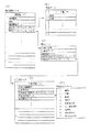
図2は、図1に示したCD−ROM3aに格納された主要なデータファイルの構成例を示している。図2(A)は経路算出手段により経路を算出し経路案内を行うために必要なデータが格納された案内道路データファイルを示し、道路数nのそれぞれに対して、道路番号、長さ、道路属性データ、形状データのアドレス、サイズおよび案内データのアドレス、サイズの各データからなってる。前記道路番号は、分岐点間の道路毎に方向(往路、復路)別に設定されている。前記形状データは、図2(B)に示すように、各道路を複数のノード(節)で分割したとき、ノード数mのそれぞれに対して東経、北緯からなる座標データを有している。
【0016】
前記案内データは、図2(C)に示すように、交差点(または分岐点)名称、注意点データ、道路名称データ、道路名称データのアドレス、サイズおよび行き先データのアドレス、サイズの各データからなる。
【0017】
前記行き先データは、図2(D)に示すように行き先道路番号、行き先名称、行き先名称音声データのアドレス、サイズおよび行き先方向データ、走行案内データからなる。前記行き先名称は、方面名称も含んでいる。また、行き先方向データは、無効(行き先方向データを使用しない)、不要(案内をしない)、直進、右方向、斜め右方向、右に戻る方向、左方向、斜め左方向、左に戻る方向の情報を示すデータである。
【0018】
次に、情報処理装置3に記憶されているデータを基にした車両用ナビゲーション装置の処理の流れについて図3により説明する。
【0019】
中央処理装置4のCPU51により経路案内システムのプログラムが起動されると、現在位置検出装置2により現在位置を検出し、情報記憶装置3に記憶されているデータを読みだし、現在位置を中心としてその周辺地図を表示すると共に、現在位置の名称等を表示する(ステップS1)。次に、地名や施設名称等の目標名、電話番号や住所、登録地点等を用いて目的地を設定し(ステップS2)、現在位置から目的地までの経路探索を行う(ステップS3)。経路が決まると、現在位置検出装置2による現在位置追跡を行いながら、目的地に到着するまで経路案内・表示を繰り返し行う(ステップS4)。
次に、図1のメモリカード3bに記憶されている本発明の軌跡データについて説明する。
本発明のシステムでは走行した道路に関するデータを軌跡データとして蓄積するためのメモリカードが接続され、探索時に、CD−ROM3aに記憶されているデータの他に、軌跡データも利用できるようになっている。
【0020】
図4は軌跡データとして記憶されるノードデータの構成例を示す図で、走行した道路軌跡を表すために所定角度以上の方位の変化があった地点を、その東経、北緯の座標として順番に番号を付してノードとして記憶する。なお、交差点番号は分岐をもつノードを交差点として識別するための識別番号であり、例えば、分岐をもたないノード「0」、分岐をもつノードは「1」である。
【0021】
図5は軌跡データとして記憶されるリンクデータの構成例を示す図で、ノード間をつないでいる線をリンクとして登録する。リンクは始点ノード番号、終点ノード番号をもっており、そのため方向性を有している。走行回数は実際に走った回数であり、走行するごとに始点→終点方向、終点→始点方向の走行回数が更新される。リンクの長さはノード間の距離であり、平均車速は、走った回数が分かっているので、各時速の累積から求まる値である。走行した日時データは、最後に走行した日時、あるいは走った履歴のデータである。道路識別は、CD−ROM3aに記憶されている道路データとの関連を持たせるための識別符号であり、CD−ROM3aに登録されている道路には、案内対象としての道路と、細い道路等案内対象外のものがあり、この識別符号は、案内対象としての道路なのか否か、或いはCD−ROM3aに登録されていない道路なのかを識別するためのものである。道路識別の中でCD−ROMのデータで案内できるデータである場合は、CD−ROMの地図データ中の道路番号が登録され、これによりCD−ROMデータによる探索結果との結びつきがなされる。リンクはCD−ROMで登録された道路よりも十分短い長さであるため、地図データ中の道路中の開始位置及び終了位置により、1つの道路中のどこに存在するかを距離で表す。
【0022】
図6は軌跡データとして記憶される交差点データの構成例を示す図で、分岐をもつノードを交差点ノードとして登録する。進入リンク数は、1つの交差点に何本のリンクが入っているかを示し、進行リンクは進入リンクに対して進行できるリンクである。ノードとリンクの関係を示す図7(a)、リンクと交差点ノードとの関係を示す図7(b)を参照すると、例えば、4差路の交差点ノードでは、進入リンク数4、1つの進入リンクに対する進行リンク数3となる。進入リンク番号ごとに、各進行リンク番号が付与され、進入→進行方向への走行回数、信号待ちや右左折時間等の通過所要平均時間、走行した日時データ(最後に通過した日時、あるいは通過した履歴のデータ)が登録される。
【0023】
次に、CD−ROMデータ、軌跡データを利用した本発明の好みのルート探索処理について説明する。
図8において、目的地を設定すると(ステップ101)、中央処理装置4のCPU51により経路案内システムのプログラムが起動される。次いで、CD−ROMデータを読みだしてルート探索が行われ(ステップ102)、例えば、図9(a)に示すようなルートR(太線)が得られる。次いで、軌跡データを読みだしてルート探索が行われ(ステップ103)、例えば、図9に示すルートRに対して、一部異なるルートR′(細線)が得られる。次いで、ルートRとR′とを比較し、両者の差からユーザーの好みを学習する(ステップ104)
軌跡データは、日常、ユーザーが実際に走行したデータを蓄積したものであるので、その内容は必然的にユーザーの好みを反映し、このデータに基いて得られた探索結果にもユーザーの好みが反映される。一方、CD−ROMデータは機械的に格納されたものであり、ユーザーが関与するのは目的地の設定、出発地のみであり、このデータに基づいて一定の観点で探索された結果はユーザーの意志とは何ら関係がない。したがって、両者を比較するとユーザーの好みを学習することができる。
【0024】
図10は好みの学習処理フローを説明する図である。まず、ルートを修正した部分(図9(a)のルートR′)をもとのルート(図9(a)のルートR)と比較する(ステップ201)。図9(a)の拡大図である図9(b)に示すように、両者のルートが異なっているP地点とQ地点間において、ルートRは曲がってはいるが1本の道路であるのに対して、ルートR′は矢印で示すように何回も右左折している。そこで、曲がった回数がもとのルートより多いか否か判断し(ステップ202)、もとのルートに対して曲がった回数が多い場合には、曲がりの際の探索コストを小さくし(ステップ203)、曲がった回数が少ない場合には曲がりの際の探索コストを大きくする(ステップ204)。図11(a)は曲がりの探索コスト係数を示し、曲がった回数がもとのルートと同じ場合の係数を1としたとき、曲がった回数が多い場合は0.8、曲がった回数が少ない場合は1.2としている。
【0025】
次いで、広い道路を走行する距離がもとのルートより多いか否か判断し(ステップ205)、多い場合には、広い道の優先度合いを上げ(ステップ206)、少ない場合は広い道の優先度合いを下げる(ステップ207)。図11(b)は広い道路の探索コスト係数を示し、もとのルートに対して広い道路が多い場合は探索コスト係数を0.8、もとのルートに対して広い道路が少ない場合は探索コスト係数を1.2としている。
【0026】
探索コスト係数は、例えば、車線数(図11(c))、所要時間(図11(d))、距離(図11(e))、信号の数(図11(f))のように、もとのルートと比較し、相違がある場合にはこれを変えるようにする。
【0027】
図8に戻って、好みの学習により、ユーザーの好みが反映された探索コストが得られたので、これに基づいてルート探索を行い(ステップ105)、目的地到着までルート案内を行っていく(ステップ106〜108)。
【0028】
なお、上記説明ではCD−ROMデータに基づいて探索されたルートと、走行軌跡データに基づいて探索されたルートとを比較し、比較結果に応じて探索コストを修正して再度経路探索を行うようにしているが、ルート探索前にCD−ROMデータと走行軌跡データとを比較して、その比較結果を経路探索に反映させるようにしてもユーザーの好みを反映することが可能である。
【図面の簡単な説明】
【図1】本発明に係るナビゲーション装置の一例を示す図である。
【図2】CD−ROMに記憶された主要なデータファイルの構成例を示す図である。
【図3】システム全体の流れを説明するためのフロー図である。
【図4】ノードデータの構成例を示す図である。
【図5】リンクデータの構成例を示す図である。
【図6】交差点データの構成例を示す図である。
【図7】ノードとリンク及びリンクと交差点ノードの関係を説明する図である。
【図8】好みのルート探索処理フローを説明する図である。
【図9】探索ルートを示す図である。
【図10】好みの学習処理を説明する図である。
【図11】探索コストを説明する図である。
【符号の説明】
1…入出力装置、2…現在位置検出装置、3…情報記憶装置、4…中央処理装置、11…タッチスイッチ、12…ディスプレイ、13…プリンタ、16…スピーカ、21…GPS受信装置、22…ビーコン受信装置、23…データ送受信装置、40…CPU、41…第1ROM、42…RAM、43…第2ROM、44…画像メモリ、45…画像プロセッサ、46…音声プロセッサ、47…通信インタフェイス、48…センサ入力インタフェイス、49…時計。[0001]
TECHNICAL FIELD OF THE INVENTION
The present invention relates to a vehicular navigation device in which a trajectory is sequentially stored in a storage device every time the vehicle travels, and the stored data is used for route search.
[0002]
[Prior art]
2. Description of the Related Art Conventionally, various route guidance devices for smoothly driving on unfamiliar roads have been proposed, and a route guidance device that guides a road to be traveled to the destination by inputting a destination. There is. In this route guidance device, road data such as intersection data and node data, map data, and the like are stored in a CD-ROM, and a route to a destination that can be reached by the shortest distance is searched, and the searched route is displayed on a screen. Display and guide.
[0003]
[Problems to be solved by the invention]
In the conventional route guidance device, a route search is performed based on the road data stored in the CD-ROM. However, the road stored in the CD-ROM used for the route search is a road having a predetermined width or more. Limited, narrow roads and the like are not targeted for route search. Further, even when there is a case where it is desired to obtain a search route utilizing a road on which the vehicle is traveling, it is not always the case that the road on which the vehicle is traveling is always included in the searched guidance route. As described above, in the route search based on the conventional CD-ROM data, a search reflecting personal preferences cannot be performed.
[0004]
The present invention has been made in view of such circumstances, and an object of the present invention is to provide a vehicle navigation device capable of reflecting a user's preference and providing detailed route guidance.
[0005]
[Means for Solving the Problems]
The vehicle navigation device according to the present invention includes a current position detecting means for detecting a current position of the vehicle, an input means for inputting a destination, data necessary for performing route guidance, and a traveling locus for each link. An information storage unit including a traveling trajectory data storage unit for storing data; and a route calculation unit for calculating a route to a destination, wherein the route calculation unit is based on data necessary for performing the route guidance. The calculated route is compared with a route calculated based on the travel locus data, and a search cost is corrected according to the comparison result to calculate a route to the destination.
Also, the navigation method of the present invention is a navigation method in which a route is calculated and guided by a route calculation means of a vehicle navigation device, wherein the route is calculated based on data necessary for performing route guidance stored in information storage means. Calculating the route by the calculating means; calculating the route by the route calculating means based on the traveling trajectory data for each link stored in the information storage means; calculating based on the data necessary for performing the route guidance Comparing the calculated route with the route calculated based on the traveling locus data by the route calculating means, and correcting the search cost by the route calculating means according to the result of the comparison to the destination route. Is calculated.
[0006]
[Action and effect of the invention]
According to the present invention, in addition to map data stored in advance in information storage means for performing route guidance, travel route data is accumulated, and a route and travel locus calculated based on map data stored in information storage means are provided. The route is compared with the route calculated based on the data, the search cost is corrected according to the comparison result, the route to the destination is calculated, and the traveling locus is reflected in the route search. For example, if there is a different portion as a result of the comparison, it is possible to perform a fine-grained route search and route guidance reflecting the user's intention by correcting the search cost for the different portion.
[0007]
BEST MODE FOR CARRYING OUT THE INVENTION
Hereinafter, embodiments of the present invention will be described with reference to the drawings.
FIG. 1 is a diagram showing an example of a navigation device according to the present invention. As shown in FIG. 1, a navigation device according to the present invention includes an input /
[0008]
The input /
[0009]
Here, a voice recognition device for enabling voice input and a recording card reading device for reading data recorded on an IC card or a magnetic card can be added. In addition, an information center that stores data necessary for navigation and provides congestion information and the like via a communication line at the request of the driver, and driver-specific data such as map data and destination data are stored in advance. It is also possible to add a data communication device for exchanging data with an information source such as an electronic organizer.
[0010]
The
[0011]
The
[0012]
The current
[0013]
The
[0014]
The
[0015]
FIG. 2 shows a configuration example of main data files stored on the CD-ROM 3a shown in FIG. FIG. 2A shows a guide road data file in which data necessary for calculating a route and performing route guidance by a route calculating means is stored. For each of the number n of roads, a road number, a length, a road It consists of address and size data of attribute data and shape data, and address and size of guidance data. The road number is set for each direction (outbound and return) for each road between the branch points. As shown in FIG. 2B, when each road is divided into a plurality of nodes (nodes), the shape data has coordinate data including east longitude and north latitude for each of the number m of nodes.
[0016]
As shown in FIG. 2 (C), the guide data includes intersection (or branch point) name, caution data, road name data, address of road name data, size, address of destination data, and size data. .
[0017]
The destination data includes a destination road number, a destination name, an address of destination name voice data, a size and a destination direction data, and travel guidance data as shown in FIG. The destination name includes a direction name. The destination direction data is invalid (do not use destination direction data), unnecessary (no guidance), straight ahead, rightward, diagonally rightward, rightward return, leftward, diagonally leftward, leftward return. This is data indicating information.
[0018]
Next, a processing flow of the vehicle navigation device based on the data stored in the
[0019]
When the program of the route guidance system is started by the CPU 51 of the
Next, the locus data of the present invention stored in the memory card 3b of FIG. 1 will be described.
In the system of the present invention, a memory card for storing data relating to the road on which the vehicle has traveled is stored as trajectory data, and at the time of searching, trajectory data can be used in addition to the data stored in the CD-ROM 3a. .
[0020]
FIG. 4 is a diagram showing a configuration example of node data stored as trajectory data. In order to represent a traveled trajectory, points where the azimuth changes by a predetermined angle or more are sequentially numbered as their east longitude and north latitude coordinates. Is stored as a node. The intersection number is an identification number for identifying a node having a branch as an intersection. For example, a node having no branch is “0”, and a node having a branch is “1”.
[0021]
FIG. 5 is a diagram showing a configuration example of link data stored as trajectory data, in which lines connecting the nodes are registered as links. The link has a start node number and an end node number, and therefore has a direction. The number of runs is the number of times the vehicle has actually run, and the number of runs in the direction from the start point to the end point and the number of runs from the end point to the start point are updated each time the vehicle runs. The link length is the distance between the nodes, and the average vehicle speed is a value obtained from the accumulation of each speed since the number of times of running is known. The run date and time data is the date and time of the last run or the data of the run history. The road identification is an identification code for associating with the road data stored in the CD-ROM 3a. The roads registered in the CD-ROM 3a include a road as a guidance target and guidance for a thin road or the like. There are some roads that are not targeted, and this identification code is used to identify whether the road is a guide target or a road that is not registered in the CD-ROM 3a. If the data can be guided by CD-ROM data in the road identification, the road number in the map data of the CD-ROM is registered, and this is linked with the search result by the CD-ROM data. Since the link is sufficiently shorter than the road registered in the CD-ROM, the start position and the end position of the road in the map data indicate where the link exists in one road by a distance.
[0022]
FIG. 6 is a diagram showing a configuration example of intersection data stored as trajectory data, in which a node having a branch is registered as an intersection node. The number of entrance links indicates how many links are included in one intersection, and the traveling links are links that can proceed with respect to the entrance links. Referring to FIG. 7A showing the relationship between nodes and links, and FIG. 7B showing the relationship between links and intersection nodes, for example, at an intersection node on a four-way road, the number of approach links is 4, and one approach link Is three. Each traveling link number is assigned to each approach link number, the number of travels in the direction of approach → travel, the average time required for passing such as signal waiting and right / left turn times, and the date and time of travel (the date and time of the last pass or History data) is registered.
[0023]
Next, a preferred route search process of the present invention using CD-ROM data and locus data will be described.
In FIG. 8, when a destination is set (step 101), the CPU 51 of the
The trajectory data is data that the user has actually traveled on a daily basis, so the content necessarily reflects the user's preferences, and the search results obtained based on this data also reflect the user's preferences. Will be reflected. On the other hand, the CD-ROM data is stored mechanically, and the user is involved only in the setting of the destination and the departure point. Based on this data, the result searched from a certain point of view is based on the user. It has nothing to do with will. Therefore, the user's preference can be learned by comparing the two.
[0024]
FIG. 10 is a diagram for explaining a preferred learning processing flow. First, the corrected portion (route R 'in FIG. 9A) is compared with the original route (route R in FIG. 9A) (step 201). As shown in FIG. 9 (b), which is an enlarged view of FIG. 9 (a), between point P and point Q where the two routes are different, the route R is a curved road but a single road. On the other hand, the route R 'turns left and right many times as shown by the arrows. Therefore, it is determined whether or not the number of turns is greater than the original route (step 202). If the number of turns relative to the original route is greater, the search cost for the turn is reduced (step 203). If the number of turns is small, the search cost for turning is increased (step 204). FIG. 11A shows a search cost coefficient for a turn, where the coefficient when the number of turns is the same as that of the original route is 1, when the number of turns is large is 0.8, and when the number of turns is small. Is 1.2.
[0025]
Next, it is determined whether or not the distance traveled on the wide road is longer than the original route (step 205). If the distance is large, the priority of the wide road is increased (step 206). Is lowered (step 207). FIG. 11B shows a search cost coefficient for a wide road. When there are many wide roads with respect to the original route, the search cost coefficient is 0.8. When there are few wide roads with respect to the original route, the search is performed. The cost coefficient is set to 1.2.
[0026]
The search cost coefficient is, for example, the number of lanes (FIG. 11 (c)), the required time (FIG. 11 (d)), the distance (FIG. 11 (e)), and the number of signals (FIG. 11 (f)). Compare with the original route, and if there is a difference, change it.
[0027]
Returning to FIG. 8, since a search cost reflecting the user's preference is obtained by learning the preference, a route search is performed based on this (step 105), and route guidance is performed until arrival at the destination (step 105).
[0028]
In the above description, the route searched based on the CD-ROM data is compared with the route searched based on the traveling locus data, the search cost is corrected according to the comparison result, and the route search is performed again. However, it is also possible to reflect the user's preference by comparing the CD-ROM data with the traveling locus data before the route search and reflecting the comparison result in the route search.
[Brief description of the drawings]
FIG. 1 is a diagram showing an example of a navigation device according to the present invention.
FIG. 2 is a diagram showing a configuration example of a main data file stored in a CD-ROM.
FIG. 3 is a flowchart for explaining the flow of the entire system.
FIG. 4 is a diagram showing a configuration example of node data.
FIG. 5 is a diagram illustrating a configuration example of link data.
FIG. 6 is a diagram illustrating a configuration example of intersection data.
FIG. 7 is a diagram illustrating the relationship between nodes and links and the relationship between links and intersection nodes.
FIG. 8 is a diagram illustrating a flow of a preferred route search process.
FIG. 9 is a diagram showing a search route.
FIG. 10 is a diagram illustrating a favorite learning process.
FIG. 11 is a diagram illustrating a search cost.
[Explanation of symbols]
REFERENCE SIGNS
Claims (6)
目的地を入力する入力手段と、
経路案内を行うために必要なデータが格納され、さらにリンク毎の走行軌跡データを蓄積する走行軌跡データ蓄積手段を含む情報記憶手段と、
目的地までの経路を算出する経路算出手段とを備え、
前記経路算出手段は、前記経路案内を行うために必要なデータに基づいて算出された経路と前記走行軌跡データに基づいて算出された経路を比較し、該比較結果に応じて探索コストを修正して目的地までの経路を算出することを特徴とするナビゲーション装置。Current position detecting means for detecting the current position of the vehicle,
Input means for inputting a destination,
Information storage means that stores data necessary for performing route guidance and further includes travel path data storage means for storing travel path data for each link;
Route calculation means for calculating a route to the destination,
The route calculation means compares a route calculated based on data necessary for performing the route guidance with a route calculated based on the traveling locus data, and corrects a search cost according to the comparison result. A navigation device for calculating a route to a destination by using the navigation device.
情報記憶手段に記憶された経路案内を行うために必要なデータに基づいて前記経路算出手段により経路を算出する段階、
情報記憶手段に記憶されたリンク毎の走行軌跡データに基づいて前記経路算出手段により経路を算出する段階、
上記経路案内を行うために必要なデータに基づいて算出された経路と、上記走行軌跡データに基づいて算出した経路とを前記経路算出手段により比較する段階、
上記比較の結果に応じて前記経路算出手段により、探索コストを修正して目的地までの経路を算出する段階、
からなるナビゲーション方法。 In a navigation method in which a route is calculated and guided by a route calculation unit of a vehicle navigation device,
Calculating a route by the route calculation unit based on data necessary for performing route guidance stored in the information storage unit;
Calculating a route by the route calculation unit based on the travel trajectory data for each link stored in the information storage unit;
Comparing the route calculated based on the data necessary for performing the route guidance with the route calculated based on the traveling locus data by the route calculating unit ;
Calculating the route to the destination by correcting the search cost by the route calculating means according to the result of the comparison;
Navigation method.
Priority Applications (5)
| Application Number | Priority Date | Filing Date | Title |
|---|---|---|---|
| JP10167096A JP3596704B2 (en) | 1996-04-23 | 1996-04-23 | Vehicle navigation device and navigation method |
| EP96119898A EP0803705B1 (en) | 1996-04-23 | 1996-12-11 | Navigation system for vehicles |
| US08/764,011 US6098015A (en) | 1996-04-23 | 1996-12-11 | Navigation system for vehicles and storage medium |
| DE69633851T DE69633851T2 (en) | 1996-04-23 | 1996-12-11 | Vehicle navigation system and storage medium |
| KR1019970006207A KR100267540B1 (en) | 1996-04-23 | 1997-02-27 | Car navigation system |
Applications Claiming Priority (1)
| Application Number | Priority Date | Filing Date | Title |
|---|---|---|---|
| JP10167096A JP3596704B2 (en) | 1996-04-23 | 1996-04-23 | Vehicle navigation device and navigation method |
Publications (2)
| Publication Number | Publication Date |
|---|---|
| JPH09287970A JPH09287970A (en) | 1997-11-04 |
| JP3596704B2 true JP3596704B2 (en) | 2004-12-02 |
Family
ID=14306813
Family Applications (1)
| Application Number | Title | Priority Date | Filing Date |
|---|---|---|---|
| JP10167096A Expired - Fee Related JP3596704B2 (en) | 1996-04-23 | 1996-04-23 | Vehicle navigation device and navigation method |
Country Status (1)
| Country | Link |
|---|---|
| JP (1) | JP3596704B2 (en) |
Cited By (1)
| Publication number | Priority date | Publication date | Assignee | Title |
|---|---|---|---|---|
| DE112009001583T5 (en) | 2008-06-27 | 2011-05-19 | Toyota Infotechnology Center Co., Ltd. | Route search device and route search method |
Families Citing this family (8)
| Publication number | Priority date | Publication date | Assignee | Title |
|---|---|---|---|---|
| JP2005156405A (en) | 2003-11-27 | 2005-06-16 | Pioneer Electronic Corp | Navigation system |
| WO2007032278A1 (en) * | 2005-09-13 | 2007-03-22 | Pioneer Corporation | Path search apparatus, path search method, path search program, and computer readable recording medium |
| US7698061B2 (en) | 2005-09-23 | 2010-04-13 | Scenera Technologies, Llc | System and method for selecting and presenting a route to a user |
| US7702456B2 (en) | 2006-04-14 | 2010-04-20 | Scenera Technologies, Llc | System and method for presenting a computed route |
| JP2009036675A (en) * | 2007-08-02 | 2009-02-19 | Sumitomo Electric System Solutions Co Ltd | Route recommendation device and program |
| JP2009229108A (en) * | 2008-03-19 | 2009-10-08 | Pioneer Electronic Corp | Navigation device, route searching method, and route searching program |
| US20120047087A1 (en) | 2009-03-25 | 2012-02-23 | Waldeck Technology Llc | Smart encounters |
| JP6377090B2 (en) * | 2016-02-24 | 2018-08-22 | 株式会社 ミックウェア | Navigation system, program |
-
1996
- 1996-04-23 JP JP10167096A patent/JP3596704B2/en not_active Expired - Fee Related
Cited By (3)
| Publication number | Priority date | Publication date | Assignee | Title |
|---|---|---|---|---|
| DE112009001583T5 (en) | 2008-06-27 | 2011-05-19 | Toyota Infotechnology Center Co., Ltd. | Route search device and route search method |
| US8583661B2 (en) | 2008-06-27 | 2013-11-12 | Toyota Jidosha Kabushiki Kaisha | Route searching apparatus and route searching method |
| DE112009001583B4 (en) * | 2008-06-27 | 2014-05-15 | Toyota Jidosha Kabushiki Kaisha | Route search device and route search method |
Also Published As
| Publication number | Publication date |
|---|---|
| JPH09287970A (en) | 1997-11-04 |
Similar Documents
| Publication | Publication Date | Title |
|---|---|---|
| KR100267540B1 (en) | Car navigation system | |
| JP3719315B2 (en) | Vehicle navigation device and storage medium | |
| JP3448134B2 (en) | Vehicle navigation system | |
| JP4069378B2 (en) | NAVIGATION DEVICE, PROGRAM FOR THE DEVICE, AND RECORDING MEDIUM | |
| JP3603927B2 (en) | Vehicle navigation device and navigation method | |
| KR100269069B1 (en) | Car navigation system and storage media | |
| JP4808050B2 (en) | Navigation device and multi-path fusion method | |
| JP4096180B2 (en) | NAVIGATION DEVICE, PROGRAM FOR THE DEVICE, AND RECORDING MEDIUM | |
| JPH1151674A (en) | Car navigation system and recording medium | |
| JP3580457B2 (en) | Vehicle navigation system | |
| US6345230B1 (en) | Vehicle navigation system and method | |
| JPH10332404A (en) | Navigation device | |
| JP3596704B2 (en) | Vehicle navigation device and navigation method | |
| JP2002202147A (en) | Navigation device | |
| JPH0962994A (en) | Navigation device for vehicle | |
| JP3580458B2 (en) | Vehicle navigation system | |
| JP2001304890A (en) | Navigation device and its storage medium | |
| WO2002003033A1 (en) | Guide display method in on-vehicle navigator | |
| JP2000337899A (en) | Navigation device and storage medium | |
| JP2000298028A (en) | Navigation device and recording medium | |
| JP2675970B2 (en) | Navigation device | |
| JP2924885B2 (en) | Vehicle navigation system | |
| JPH10122890A (en) | Navigator for vehicle | |
| JP3760958B2 (en) | Navigation device | |
| JPH0989580A (en) | Navigation system for vehicle |
Legal Events
| Date | Code | Title | Description |
|---|---|---|---|
| A977 | Report on retrieval |
Free format text: JAPANESE INTERMEDIATE CODE: A971007 Effective date: 20040216 |
|
| A131 | Notification of reasons for refusal |
Free format text: JAPANESE INTERMEDIATE CODE: A131 Effective date: 20040305 |
|
| A521 | Written amendment |
Free format text: JAPANESE INTERMEDIATE CODE: A523 Effective date: 20040506 |
|
| A131 | Notification of reasons for refusal |
Free format text: JAPANESE INTERMEDIATE CODE: A131 Effective date: 20040702 |
|
| A521 | Written amendment |
Free format text: JAPANESE INTERMEDIATE CODE: A523 Effective date: 20040715 |
|
| TRDD | Decision of grant or rejection written | ||
| A01 | Written decision to grant a patent or to grant a registration (utility model) |
Free format text: JAPANESE INTERMEDIATE CODE: A01 Effective date: 20040820 |
|
| A61 | First payment of annual fees (during grant procedure) |
Free format text: JAPANESE INTERMEDIATE CODE: A61 Effective date: 20040902 |
|
| R150 | Certificate of patent (=grant) or registration of utility model |
Free format text: JAPANESE INTERMEDIATE CODE: R150 |
|
| FPAY | Renewal fee payment (prs date is renewal date of database) |
Free format text: PAYMENT UNTIL: 20070917 Year of fee payment: 3 |
|
| FPAY | Renewal fee payment (prs date is renewal date of database) |
Free format text: PAYMENT UNTIL: 20080917 Year of fee payment: 4 |
|
| FPAY | Renewal fee payment (prs date is renewal date of database) |
Free format text: PAYMENT UNTIL: 20090917 Year of fee payment: 5 |
|
| FPAY | Renewal fee payment (prs date is renewal date of database) |
Free format text: PAYMENT UNTIL: 20090917 Year of fee payment: 5 |
|
| FPAY | Renewal fee payment (prs date is renewal date of database) |
Free format text: PAYMENT UNTIL: 20100917 Year of fee payment: 6 |
|
| FPAY | Renewal fee payment (prs date is renewal date of database) |
Free format text: PAYMENT UNTIL: 20110917 Year of fee payment: 7 |
|
| FPAY | Renewal fee payment (prs date is renewal date of database) |
Free format text: PAYMENT UNTIL: 20110917 Year of fee payment: 7 |
|
| FPAY | Renewal fee payment (prs date is renewal date of database) |
Free format text: PAYMENT UNTIL: 20120917 Year of fee payment: 8 |
|
| FPAY | Renewal fee payment (prs date is renewal date of database) |
Free format text: PAYMENT UNTIL: 20130917 Year of fee payment: 9 |
|
| LAPS | Cancellation because of no payment of annual fees |