EP1137305B1 - Method and system for locating mobile stations in a mobile communication network - Google Patents
Method and system for locating mobile stations in a mobile communication network Download PDFInfo
- Publication number
- EP1137305B1 EP1137305B1 EP20010850054 EP01850054A EP1137305B1 EP 1137305 B1 EP1137305 B1 EP 1137305B1 EP 20010850054 EP20010850054 EP 20010850054 EP 01850054 A EP01850054 A EP 01850054A EP 1137305 B1 EP1137305 B1 EP 1137305B1
- Authority
- EP
- European Patent Office
- Prior art keywords
- mobile stations
- stations
- ordinates
- mobile
- location
- Prior art date
- Legal status (The legal status is an assumption and is not a legal conclusion. Google has not performed a legal analysis and makes no representation as to the accuracy of the status listed.)
- Expired - Lifetime
Links
- 238000000034 method Methods 0.000 title claims description 52
- 238000010295 mobile communication Methods 0.000 title claims description 4
- 238000005259 measurement Methods 0.000 claims description 51
- 102100039124 Methyl-CpG-binding protein 2 Human genes 0.000 description 6
- 238000004891 communication Methods 0.000 description 4
- 230000001413 cellular effect Effects 0.000 description 3
- 230000005540 biological transmission Effects 0.000 description 2
- 238000004364 calculation method Methods 0.000 description 2
- 238000005516 engineering process Methods 0.000 description 2
- 239000011159 matrix material Substances 0.000 description 2
- 238000004088 simulation Methods 0.000 description 2
- 230000001360 synchronised effect Effects 0.000 description 2
- 101001128138 Homo sapiens NACHT, LRR and PYD domains-containing protein 2 Proteins 0.000 description 1
- 101000981336 Homo sapiens Nibrin Proteins 0.000 description 1
- 102100024403 Nibrin Human genes 0.000 description 1
- 238000013459 approach Methods 0.000 description 1
- VRSMQRZDMZDXAU-UHFFFAOYSA-N bis(sulfanylidene)niobium Chemical compound S=[Nb]=S VRSMQRZDMZDXAU-UHFFFAOYSA-N 0.000 description 1
- 230000001186 cumulative effect Effects 0.000 description 1
- 238000010586 diagram Methods 0.000 description 1
- 239000012895 dilution Substances 0.000 description 1
- 238000010790 dilution Methods 0.000 description 1
- 238000005315 distribution function Methods 0.000 description 1
- 238000011156 evaluation Methods 0.000 description 1
- 238000009472 formulation Methods 0.000 description 1
- 238000013208 measuring procedure Methods 0.000 description 1
- 239000000203 mixture Substances 0.000 description 1
- 238000012986 modification Methods 0.000 description 1
- 230000004048 modification Effects 0.000 description 1
- 238000012545 processing Methods 0.000 description 1
- 239000000243 solution Substances 0.000 description 1
Images


Classifications
-
- H—ELECTRICITY
- H04—ELECTRIC COMMUNICATION TECHNIQUE
- H04W—WIRELESS COMMUNICATION NETWORKS
- H04W64/00—Locating users or terminals or network equipment for network management purposes, e.g. mobility management
-
- G—PHYSICS
- G01—MEASURING; TESTING
- G01S—RADIO DIRECTION-FINDING; RADIO NAVIGATION; DETERMINING DISTANCE OR VELOCITY BY USE OF RADIO WAVES; LOCATING OR PRESENCE-DETECTING BY USE OF THE REFLECTION OR RERADIATION OF RADIO WAVES; ANALOGOUS ARRANGEMENTS USING OTHER WAVES
- G01S5/00—Position-fixing by co-ordinating two or more direction or position line determinations; Position-fixing by co-ordinating two or more distance determinations
- G01S5/02—Position-fixing by co-ordinating two or more direction or position line determinations; Position-fixing by co-ordinating two or more distance determinations using radio waves
- G01S5/10—Position of receiver fixed by co-ordinating a plurality of position lines defined by path-difference measurements, e.g. omega or decca systems
Definitions
- the invention is concerned with the location of mobile stations within a mobile communication network including mobile stations and base stations.
- Location based services for mobile stations are expected to play an important role in future applications of wireless systems. Some examples of such services are emergency services, road assistance, location based "yellow pages" and traffic information.
- a wide variety of technologies for locating mobile stations have been developed. Many of these have been targeted towards the United States Federal Communication Commission (US FCC) requirement to determine the location of emergency 911 callers with high accuracy. These technologies may be classified into external methods or network based methods.
- An example of an external method is the Global Positioning System (GPS).
- GPS Global Positioning System
- the network based methods can be further categorized depending on whether it is the network or the mobile station that performs necessary signal measurements.
- the signal measurements themselves may involve the reception time of signals communicated between a base station BS and a mobile station MS, the angle of arriving signals or round trip delay measurements of signals communicated between a serving BS and an MS, or combinations thereof.
- LMUs Location Measurement Units
- the currently available network information with respect to MS location includes the identity of the serving cell, timing advance and measurement reports from the MS.
- the timing advance is an estimate of a signal propagation time and is used for calculating the distance between the serving BS and the MS.
- the MS measurement reports include measurements of the received signal strengths and identities of neighboring BS's as well as those of the serving BS.
- Time of Arrival (TOA) measurements provide a propagation time of signals between an MS and a BS.
- Time Difference of Arrival (TDOA) measurements provide the difference of signal propagation time of signals between the MS and two different BS's. The measurements of the two BS's are then used for calculating the actual position of the MS. This procedure, using well-known geometric equations, is called triangulation.
- a mobile station MS is capable of communication with at least three base stations BS1 - BS3.
- the distance between the MS and each of the three BS's is measured using the TOA technique.
- the measured distance R1 of BS1 defines a circle C1 around BS1, and the MS is located somewhere on the circle C1.
- distances R2 and R3 of BS2 and BS3 respectively are measured for defining the corresponding circles C2 and C3.
- the intersection of the circles C1, C2 and C3 define the location of the MS.
- the position determinations use TDOA calculations which are further based on Time of Arrival (TOA) measurements.
- TOA Time of Arrival
- the position of the mobile station is located at or near the point where a plurality of hyperbolic arcs cross over one another. Such a method is described in the International Patent Application WO 99/29130 .
- the two most common known positioning methods are the Down-link Observed Time Difference of Arrival method (DL-OTDOA) and the Up-link Time of Arrival method (UL-TOA).
- DL-OTDOA Down-link Observed Time Difference of Arrival method
- UL-TOA Up-link Time of Arrival method
- the DL-OTDOA method is based on measurements performed by the MS.
- FIG. 2 illustrates how the DL-OTDOA method works.
- a mobile station is capable of communication with a serving base station SBS at a distance d0 and further with two neighboring base stations NBS1 and NBS2 at distances d1 and d2 respectively.
- OTDOAs of downlink signals received from two base stations define a hyperbola, which is illustrated with dotted lines in Figure 2.
- the areas indicated outside the dotted lines represent measurement error margins.
- a plurality of hyperbolas can be defined and the MS will be located in the intersection of these hyperbolas, which is indicated as a black area including the respective measurement error margins.
- the Real Time Differences In order to compensate for any non-time aligned transmissions from the different BSs, the Real Time Differences (RTDs) must be known if the BSs are not time synchronized, e.g., to a global time reference.
- the RTDs can be obtained e.g. by having LMUs in at least some of the BSs.
- UL-TOA works in a similar manner, although in this case, the BSs make measurements on uplink signals transmitted by the MS.
- the accuracy of the method depends on, e.g., the accuracy of the measurements but also on the relative positions of the MS and the BSs involved.
- the accuracy can be very poor for some configurations, which is sometimes referred to as Geometrical Dilution of Precision (GDOP).
- GDOP is defined as the accuracy of the position fix divided by the accuracy of the measurements.
- the object of the invention is to provide a simple method of locating mobile stations in connection with unsynchronized base stations without requiring Location Measurement Units (LMUs).
- LMUs Location Measurement Units
- a method and apparatus for identifying locations of a plurality of mobile cellular phones is described in US 5 973 643 A , wherein a network is divided into specific geographical areas, each comprising a number of distributed mobile location sensors (MLS), which are connected to a central real-time location processor (RLP) associated to an MSC.
- the mobile location sensors receive and measure signals transmitted from mobile cellular telephones which are active within the respective geographical area. Measured data is forwarded to the respective RLP for processing and finally, processed location information is forwarded to an available location application.
- Each mobile location sensor may be located in juxtaposition to a base station, using the respective base stations antenna for receiving signals, or a unit separate from the respective base station, having its own antenna.
- SDMA spatial division multiple access
- the location of mobile stations in a communication network includes locating at least two mobile stations simultaneously by minimizing a cost-function, which is achieved by using a sufficient number of equations.
- the location of a mobile station is a function of the location of a base station in the network, and performed signal measurements including reception times.
- the signal measurements may be performed by the mobile stations and comprise receiving times of signals received from base stations in the network and optionally Round Trip Time (RTT) measurements.
- RTT Round Trip Time
- the Round Trip Time is the signal propagation time from a base station to a mobile station and back.
- RTT Round Trip Time
- the location of a mobile station is described by geographical co-ordinates of pre-determined dimensions, typically two or three co-ordinates.
- the number of equations, the number of simultaneously located mobile stations and the number of involved base stations needed for determining the location of mobile stations, all depend on the pre-determined dimensions of the co-ordinates and the knowledge of RTTs.
- simultaneously means that signal measurements are made close enough in time such that the BS clocks have not drifted significantly. In practice, this could mean for instance that the measurements must be made within approximately one minute.
- the minimization of a cost-function provides the locations of the at least two MSs.
- the cost-function can be obtained by means of a sufficient number of equations, each of which includes an MS location as a function of the location of a BS and performed signal measurements.
- T ij T i + d ij / C + ⁇ j + e ij
- T i T 1 , ...
- T ij denotes the reception time at MSj of a signal from BSi
- ⁇ j ⁇ 1 , ⁇ 2 ...
- the location of an MS can be defined by either two or three geographical co-ordinates depending on whether it is necessary to determine the height position.
- the third height co-ordinate may be needed in, e.g., mountainous environments or multi-floor buildings.
- the number of equations must be at least equal to the number of unknowns. If the RTT of one BS is known for all MSs, the number of equations is nm*nb + nm. If no RTT is known, the number of equations is nm * nb. In both cases, the number of unknowns is (C+1)*nm + nb -1, where C is the number of used co-ordinates, i.e., 2 or 3. C*nm is the number of unknown co-ordinates for nm MSs, nb is the number of unknown transmit times T i , and nm -1 is the number of unknown time offsets ⁇ j .
- the following tables show the number of equations minus the number of unknowns for different numbers of MSs and BSs and combinations thereof.
- the tables include cases using two- or three-dimensional co-ordinates as well as cases with or without knowledge about the RTT of one BS. TABLE 1.
- the number of equations minus the number of unknowns when two-dimensional co-ordinates are used and the RTTs to one BS from all MSs are known.
- n.MS/nBS 1 2 3 4 5 6 1 -1 -1 -1 -1 -1 -1 -1 2 -2 -1 0 1 2 3 3 -3 -1 1 3 5 7 TABLE 2.
- Figure 3 illustrates a preferred embodiment of the invention being implemented in a simple scenario involving two mobile stations MS1, MS2 and three base stations BS1 - BS3.
- BS1 is the current serving base station for both MS1 and MS2.
- Both MS1 and MS2 measure and report reception times, or Times of Arrival, TOAs, of signals sent from BS1, BS2 and BS3 respectively.
- T ij is the reception time at MSj of a signal from BSi, see (1).
- RTTs are measured at BS1 for both MS1 and MS2.
- T 11 T 1 + d 11 / c
- T 21 T 2 + d 21 / c
- T 31 T 3 + d 31 / c
- T 12 T 1 + d 12 / c + ⁇ 2
- T 22 T 2 + d 22 / c + ⁇ 2
- T 32 T 3 + d 32 / c + ⁇ 2
- RTT 11 2 * d 11 / c
- RTT 12 2 * d 12 / c
- MS2 is located somewhere on a circle defined by the location of BS1 and d 12 .
- MS1 is located somewhere on a circle defined by the location of BS1 and d 11 .
- T 1 can be determined by inserting d 11 from (10) into (3). Then, ⁇ 2 can be determined by inserting T 1 and d 12 from (9) into (6).
- MS1 is located at a position defined by the following three circles:
- MS2 is located at a position defined by the following three circles:
- d 21 and d 32 which are unknown, can be estimated graphically by adjusting them until the three circles corresponding to MS1 intersect at one point at the same time as the three circles corresponding to MS2 intersect at another point. Note that when d 21 and d 32 are adjusted, d 22 and d 31 are also adjusted such that the distance differences D2 and D3 between the radii are maintained. The co-ordinates of the two intersecting points will then provide the locations of MS1 and MS2.
- the MS locations may be determined with a minimization approach, e.g., using the least square method. In short, this means that the MS locations are selected such that the summed squared distance from the MSs to the above described six circles, i.e., three circles per MS, is minimized. This is generally referred to as minimizing a cost-function.
- V M 1 ⁇ M 2 y ⁇ 1 - f ⁇ 1 y ⁇ 2 - f ⁇ 2 RTT 11 - d 11 / c RTT 12 - d 12 / c Q y ⁇ 1 - f ⁇ 1 y ⁇ 2 - f ⁇ 2 RTT 11 - d 11 / c RTT 12 - d 12 / c ⁇ ⁇ Q is a weighting matrix, which is normally based on estimates of the measurement errors in the equations (9) - (10), (13) - (14).
- three BSs are located in a uniform pattern and 1000 MSs are randomly located in the surrounding area.
- the true TOAs are calculated and an error corresponding to 100 m is added to all TOA values (including those calculated from measurements performed by LMUs and BSs).
- the MS locations are then estimated with the least square method for both the method according to the invention and the previously known OTDOA method using LMUs.
- the invented method is evaluated in the case when RTT measurements are performed and when two-dimensional co-ordinates are considered.
- the standard OTDOA method is evaluated for the same MSs.
- the results of this evaluation are shown in figure 4, which presents the cumulative distribution functions of the errors for the method of the invention and for the standard OTDOA method using LMUs.
- the performance of the invented method is slightly poorer than the OTDOA method, but on the other hand, it is much less expensive to implement.
- One reason for the inferior performance is the properties of the GDOP.
Landscapes
- Engineering & Computer Science (AREA)
- Physics & Mathematics (AREA)
- General Physics & Mathematics (AREA)
- Radar, Positioning & Navigation (AREA)
- Remote Sensing (AREA)
- Computer Networks & Wireless Communication (AREA)
- Signal Processing (AREA)
- Position Fixing By Use Of Radio Waves (AREA)
Description
- The invention is concerned with the location of mobile stations within a mobile communication network including mobile stations and base stations.
- Location based services for mobile stations are expected to play an important role in future applications of wireless systems. Some examples of such services are emergency services, road assistance, location based "yellow pages" and traffic information.
- A wide variety of technologies for locating mobile stations have been developed. Many of these have been targeted towards the United States Federal Communication Commission (US FCC) requirement to determine the location of emergency 911 callers with high accuracy. These technologies may be classified into external methods or network based methods. An example of an external method is the Global Positioning System (GPS). The network based methods can be further categorized depending on whether it is the network or the mobile station that performs necessary signal measurements. The signal measurements themselves may involve the reception time of signals communicated between a base station BS and a mobile station MS, the angle of arriving signals or round trip delay measurements of signals communicated between a serving BS and an MS, or combinations thereof.
- Most methods require specific hardware in the MS and/or in the network. Furthermore, Location Measurement Units (LMUs) are required for some methods to obtain knowledge about the relative time differences for sending signals to different mobile stations. This means that the operator is faced with an initial cost for investing in new equipment. This applies for both network and MS based methods.
For many location based services, it is expected that an accuracy of 500 m or even more is sufficient. For these types of services, investments in new expensive equipment is not easily justified. For some cases, a phased solution is the most attractive choice. The operator will then initially offer services based on low accuracy positioning methods and may later invest in new equipment as the revenues increase. - For these reasons, it is of interest to investigate what can be done with a minimum of network impact. The currently available network information with respect to MS location includes the identity of the serving cell, timing advance and measurement reports from the MS. The timing advance is an estimate of a signal propagation time and is used for calculating the distance between the serving BS and the MS. The MS measurement reports include measurements of the received signal strengths and identities of neighboring BS's as well as those of the serving BS.
- Time of Arrival (TOA) measurements provide a propagation time of signals between an MS and a BS. Time Difference of Arrival (TDOA) measurements provide the difference of signal propagation time of signals between the MS and two different BS's. The measurements of the two BS's are then used for calculating the actual position of the MS. This procedure, using well-known geometric equations, is called triangulation.
- In a TOA measuring procedure as illustrated in figure 1, a mobile station MS is capable of communication with at least three base stations BS1 - BS3. In order to determine the position of the MS, the distance between the MS and each of the three BS's is measured using the TOA technique. The measured distance R1 of BS1 defines a circle C1 around BS1, and the MS is located somewhere on the circle C1. Likewise, distances R2 and R3 of BS2 and BS3 respectively, are measured for defining the corresponding circles C2 and C3. The intersection of the circles C1, C2 and C3 define the location of the MS. This technique is further described in the
International Patent Application WO 99/21389 - In the Time Difference of Arrival (TDOA) measuring technique, the position determinations use TDOA calculations which are further based on Time of Arrival (TOA) measurements. In this method, the position of the mobile station is located at or near the point where a plurality of hyperbolic arcs cross over one another. Such a method is described in the
International Patent Application WO 99/29130 - The two most common known positioning methods are the Down-link Observed Time Difference of Arrival method (DL-OTDOA) and the Up-link Time of Arrival method (UL-TOA). The DL-OTDOA method is based on measurements performed by the MS.
- Figure 2 illustrates how the DL-OTDOA method works. A mobile station is capable of communication with a serving base station SBS at a distance d0 and further with two neighboring base stations NBS1 and NBS2 at distances d1 and d2 respectively. OTDOAs of downlink signals received from two base stations define a hyperbola, which is illustrated with dotted lines in Figure 2. The areas indicated outside the dotted lines represent measurement error margins. When three or more BSs are available, a plurality of hyperbolas can be defined and the MS will be located in the intersection of these hyperbolas, which is indicated as a black area including the respective measurement error margins. In order to compensate for any non-time aligned transmissions from the different BSs, the Real Time Differences (RTDs) must be known if the BSs are not time synchronized, e.g., to a global time reference. The RTDs can be obtained e.g. by having LMUs in at least some of the BSs.
- UL-TOA works in a similar manner, although in this case, the BSs make measurements on uplink signals transmitted by the MS.
- The accuracy of the method depends on, e.g., the accuracy of the measurements but also on the relative positions of the MS and the BSs involved. The accuracy can be very poor for some configurations, which is sometimes referred to as Geometrical Dilution of Precision (GDOP). Mathematically, GDOP is defined as the accuracy of the position fix divided by the accuracy of the measurements.
- The object of the invention is to provide a simple method of locating mobile stations in connection with unsynchronized base stations without requiring Location Measurement Units (LMUs).
- A method and apparatus for identifying locations of a plurality of mobile cellular phones is described in
US 5 973 643 A , wherein a network is divided into specific geographical areas, each comprising a number of distributed mobile location sensors (MLS), which are connected to a central real-time location processor (RLP) associated to an MSC. The mobile location sensors receive and measure signals transmitted from mobile cellular telephones which are active within the respective geographical area. Measured data is forwarded to the respective RLP for processing and finally, processed location information is forwarded to an available location application. Each mobile location sensor may be located in juxtaposition to a base station, using the respective base stations antenna for receiving signals, or a unit separate from the respective base station, having its own antenna. - Another method and apparatus, introducing spatial division multiple access (SDMA), for executing the estimation of the location of multiple cellular mobile stations simultaneously is described in
US 5 515 378 A . Time-of arrival (TOA) and/or direction-of arrival (DOA) are measured at a number of base stations, The retrieved measurement results are processed in a Spatial Division Multiple Access (SDMA) controller for retrieving estimates of location of users. - These alternative methods for locating mobile stations do, however, require considerable modifications to existing hardware, and are therefore not concerned with minimising the network impact when determining MS locations as is the object of the present invention.
- The location of mobile stations in a communication network according to the invention includes locating at least two mobile stations simultaneously by minimizing a cost-function, which is achieved by using a sufficient number of equations. In each of these equations, the location of a mobile station is a function of the location of a base station in the network, and performed signal measurements including reception times. Thereby, the need for LMUs is eliminated for locating mobile stations using unsynchronized base stations.
- The signal measurements may be performed by the mobile stations and comprise receiving times of signals received from base stations in the network and optionally Round Trip Time (RTT) measurements. The Round Trip Time is the signal propagation time from a base station to a mobile station and back. Depending on the situation, it is decided whether to perform measurements of RTT for a serving or neighboring base station. This decision may depend on, e.g., the equipment being available or the complexity of the network system.
- The location of a mobile station is described by geographical co-ordinates of pre-determined dimensions, typically two or three co-ordinates. The number of equations, the number of simultaneously located mobile stations and the number of involved base stations needed for determining the location of mobile stations, all depend on the pre-determined dimensions of the co-ordinates and the knowledge of RTTs.
- By positioning at least two MSs simultaneously, it is possible to avoid the requirement of using LMUs when the BSs are unsynchronized. In this context, simultaneously means that signal measurements are made close enough in time such that the BS clocks have not drifted significantly. In practice, this could mean for instance that the measurements must be made within approximately one minute.
- In the following, some preferred embodiments of the invention are described with reference to the figures below. However, the invention is not in any way limited to the various details of the described embodiments, which are presented for illustrative purposes only.
-
- Figure 1 is a schematic view illustrating a prior art positioning method.
- Figure 2 is a schematic view illustrating another prior art positioning method.
- Figure 3 is a schematic view of a preferred embodiment of the invention.
- Figure 4 is a diagram presenting simulation results of the method of the invention compared with results of a prior art method.
- When determining the location of at least two mobile stations MSs by performing signal measurements involving at least three base stations BSs, the minimization of a cost-function provides the locations of the at least two MSs. The cost-function can be obtained by means of a sufficient number of equations, each of which includes an MS location as a function of the location of a BS and performed signal measurements.
- In the general case, the distance between a BSi and an MSj is given by the following equation:

where
Ti = T1, ... Tnb denotes the transmission time from BSi = BS1... BSnb,
Tij denotes the reception time at MSj of a signal from BSi,
τj = τ1, τ2... τnm denotes a time-offset which is the difference in time-base used as reference by MS1, MS2...MSnm, compared to a common time reference,
c is the propagation speed of the radio waves,
eij represents measurement errors,
j = 1, ..., nm, where nm denotes the number of MSs,
i = 1, ..., nb, where nb denotes the number of BSs, and
dij is the distance between BSi and MSj.
dij can be expressed as:
where
Mj denotes the co-ordinates of MSj, and
Bi denotes the co-ordinates of BSi. - Since the MS measurements are performed with reference to the time-base of each respective mobile station, the relations between the MS time-bases, given by τ, are additional unknown terms since the MSs are not synchronized, i.e., do not have a common time reference. A common clock reference may be defined to be equal to the clock of, e.g., MS1, hence τ1 = 0, which reduces the number of unknown terms by one. Furthermore, each BS may be able to measure the round trip time RTT of signals from the BS to an MS and back. This measurement is related to the distance between MSj and BSi as:

where vij denotes a measurement error. Note that the equation (2) allows for RTT to be defined for more than one BS per MS. - The location of an MS can be defined by either two or three geographical co-ordinates depending on whether it is necessary to determine the height position. The third height co-ordinate may be needed in, e.g., mountainous environments or multi-floor buildings.
- It is a well-known fact that in order to calculate unknown values, the number of equations must be at least equal to the number of unknowns. If the RTT of one BS is known for all MSs, the number of equations is nm*nb + nm. If no RTT is known, the number of equations is nm * nb. In both cases, the number of unknowns is (C+1)*nm + nb -1, where C is the number of used co-ordinates, i.e., 2 or 3. C*nm is the number of unknown co-ordinates for nm MSs, nb is the number of unknown transmit times Ti, and nm -1 is the number of unknown time offsets τj.
- The following tables show the number of equations minus the number of unknowns for different numbers of MSs and BSs and combinations thereof. The tables include cases using two- or three-dimensional co-ordinates as well as cases with or without knowledge about the RTT of one BS.
TABLE 1. The number of equations minus the number of unknowns when two-dimensional co-ordinates are used and the RTTs to one BS from all MSs are known. n.MS/nBS 1 2 3 4 5 6 1 -1 -1 -1 -1 -1 -1 2 -2 -1 0 1 2 3 3 -3 -1 1 3 5 7 TABLE 2. The number of equations minus the number of unknowns when two-dimensional co-ordinates are used and the RTTs are unknown. n.MS/nBS 1 2 3 4 5 6 1 -2 -2 -2 -2 -2 -2 2 -4 -3 -2 -1 0 1 3 -6 -4 -2 0 2 4 4 -8 -5 -2 1 4 7 TABLE 3. The number of equations minus the number of unknowns when three-dimensional co-ordinates are used and the RTTs are known. n.MS/nBS 1 2 3 4 5 6 1 -2 -2 -2 -2 -2 -2 2 -4 -3 -2 -1 0 1 3 -6 -4 -2 0 2 4 TABLE 4. The number of equations minus the number of unknowns when three-dimensional co-ordinates are used and the RTTs are unknown. n.MS/nBS 1 2 3 4 5 6 7 1 -3 -3 -3 -3 -3 -3 -3 2 -6 -5 -4 -3 -2 -1 0 3 -9 -7 -5 -3 -1 1 3 - From these tables, it is understood that the calculations are significantly simpler when two-dimensional co-ordinates are used.
- The requirement of a necessary number of equations versus number of unknowns is not the only condition for performing successful location determinations. There are degenerate cases of geographical MS distribution when the geometry makes it impossible to determine the MS positions. A trivial example of a degenerate case is when the MSs are very close to each other, which will lead to poor GDOP.
- Figure 3 illustrates a preferred embodiment of the invention being implemented in a simple scenario involving two mobile stations MS1, MS2 and three base stations BS1 - BS3. In this example, BS1 is the current serving base station for both MS1 and MS2.
- Both MS1 and MS2 measure and report reception times, or Times of Arrival, TOAs, of signals sent from BS1, BS2 and BS3 respectively. Generally, Tij is the reception time at MSj of a signal from BSi, see (1). RTTs are measured at BS1 for both MS1 and MS2. For illustration purposes only, we assume that the measurements are noise free, wherein the resulting equations are (see also (1),(2)):


- From equation (10), it can be concluded that MS2 is located somewhere on a circle defined by the location of BS1 and d12. Correspondingly from (9), MS1 is located somewhere on a circle defined by the location of BS1 and d11.
- T1 can be determined by inserting d11 from (10) into (3). Then, τ2 can be determined by inserting T1 and d12 from (9) into (6).
- Now, D2 is defined as the difference in distance of MS1 and MS2 to BS2:

D2 is related to the difference in propagation delay for signals from BS2 to MS2 and MS1, i.e., D2 can be calculated by subtracting (7) from (4) with the following result: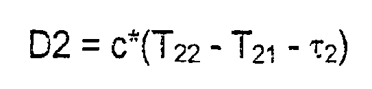
- Correspondingly, D3 is defined as the difference in distance of MS1 and MS2 to BS3, being related to the difference in propagation delay for signals from BS3 to MS1 and MS2, i.e.,

- Note that we have changed the order of MS1 and MS2 in order to ensure that D2 is a positive distance according to Figure 3. This is done solely for illustration purposes. D3 can be derived by subtracting (5) from (8):

- Thus, MS1 is located at a position defined by the following three circles:
- the circle defined by the location of BS1 and d11,
- the circle defined by the location of BS2 and d21 and
- the circle defined by the location of BS3 and d32 + D3.
- MS2 is located at a position defined by the following three circles:
- the circle defined by the location of BS1 and d12,
- the circle defined by the location of BS2 and d21 + D2, and
- the circle defined by the location of BS3 and d32.
- In the non-degenerate case, d21 and d32, which are unknown, can be estimated graphically by adjusting them until the three circles corresponding to MS1 intersect at one point at the same time as the three circles corresponding to MS2 intersect at another point. Note that when d21 and d32 are adjusted, d22 and d31 are also adjusted such that the distance differences D2 and D3 between the radii are maintained. The co-ordinates of the two intersecting points will then provide the locations of MS1 and MS2.
- In practice, measurement errors will occur such that the six circles do not intersect at two exact locations. In the normal case, the MS locations may be determined with a minimization approach, e.g., using the least square method. In short, this means that the MS locations are selected such that the summed squared distance from the MSs to the above described six circles, i.e., three circles per MS, is minimized. This is generally referred to as minimizing a cost-function.
- In the following, we illustrate the least squares process in a slightly more generic setting. First, the unknown transmit times and clock offsets are eliminated by subtracting twice: Equations (7) - (6) - ((4) - (3)) and ((8) - (6) - (5) - (3)) give:


where e1, e2 represent the sum of individual measurement errors. In (13) and (14), the only unknowns are the MS location co-ordinates M1 M2 contained in the dij's. By adding the RTT measurements of (9) and (10), we have four equations and four unknowns. In order to simplify notation, the following is defined:


- Finally, the least squares criterion is defined in matrix formulation:

Q is a weighting matrix, which is normally based on estimates of the measurement errors in the equations (9) - (10), (13) - (14). - Estimates of the location co-ordinates M1 and M2 are obtained as the minimizing arguments of the least squares criterion (15):

- In order to evaluate the likelihood of bad GDOP, the invented method has been evaluated with numerical simulations and compared to a prior art method.
- It should be noted that after the MS locations have been calculated, the relative time differences RTDs of the involved BSs are known. This means that, if the location of a further MS is to be determined, it is sufficient to perform measurements by that MS only, provided that the BSs clocks have not drifted significantly in relation to each other.
- In this further example, three BSs are located in a uniform pattern and 1000 MSs are randomly located in the surrounding area. The true TOAs are calculated and an error corresponding to 100 m is added to all TOA values (including those calculated from measurements performed by LMUs and BSs). The MS locations are then estimated with the least square method for both the method according to the invention and the previously known OTDOA method using LMUs.
- The invented method is evaluated in the case when RTT measurements are performed and when two-dimensional co-ordinates are considered. As a reference, the standard OTDOA method is evaluated for the same MSs. The results of this evaluation are shown in figure 4, which presents the cumulative distribution functions of the errors for the method of the invention and for the standard OTDOA method using LMUs. As might be expected, the performance of the invented method is slightly poorer than the OTDOA method, but on the other hand, it is much less expensive to implement. One reason for the inferior performance is the properties of the GDOP.
Claims (20)
- A method of locating mobile stations within a mobile communication network including a plurality of mobile stations (MS1 -MSnm) and a plurality of base stations (BS1-BSnb), wherein;
measurements are performed on signals communicated between at least three base stations (BS1,BS2,BS3);and at least two mobile stations(MS1,MS2); characterised by the step of:locating the at least two mobile stations simultaneously by N number of equations, wherein N is:wherein nm is the number of located mobile stations, nb is the number of involved base stations, RTT is the round trip time for a BS and a MS which is measured from the BS to the MS and back, andnm*nb +nm; if the round trip time (RTT) of one base stationor
is known for all mobile stationsnm*nb; if no RTT is known
wherein each equation comprises the location of a mobile station as a function of the location of a base station and the performed signal measurements. - The method of claim 1, wherein the performed signal measurements include the reception time of signals communicated between said at least three base stations and said at least two mobile stations.
- The method of claim 1, wherein the performed signal measurements include the Round Trip Time of signals communicated between said at least three base stations and said at least two mobile stations.
- The method of claim 1, wherein the locations of the mobile stations are defined by co-ordinates of pre-determined dimensions.
- The method of claim 4, wherein the locations of the mobile stations are defined by two co-ordinates.
- The method of claim 4, wherein the locations of the mobile stations are defined by three co-ordinates.
- The method of claim 4, wherein said number of equations is based on said pre-determined dimensions of the co-ordinates.
- The method of claim 3, wherein said number of equations is based on the knowledge of said Round Trip Times.
- The method of claim 1, wherein the number of simultaneously located mobile stations and the number of base stations being involved in said performed signal measurements are based on the knowledge of measured Round Trip Times and pre-determined dimensions of co-ordinates defining the locations of the mobile stations.
- The method of claim 1, wherein said signal measurements are performed within one minute such that clocks in the base stations have not drifted significantly in relation to each other.
- A system of locating mobile stations within a mobile communication network including a plurality of mobile stations (MS1 -MSnm) and a plurality of base stations (BS1-BSnb) wherein;
measurements are performed on signals communicated between at least three base stations (BS1, BS2, BS3); and at least two mobile stations(MS1,MS2); characterised by:means for locating the at least two mobile stations simultaneously by N number of equations, wherein N is:wherein nm is the number of located mobile stations, nb is the number of involved base stations, RTT is the round trip time for a BS and a MS which is measured from the BS to the MS and back; andnm*nb +nm; if the round trip time (RTT) of one base stationor
is known for all mobile stationsnm*nb; if no RTT is known
wherein each equation comprises the location of a mobile station as a function of the location of a base station and the performed signal measurements. - The system of claim 11, wherein said performed signal measurements include the reception time of signals communicated between said at least three base stations and said at least two mobile stations.
- The system of claim 11, wherein said performed signal measurements include the Round Trip Time of signals communicated between said at least three base stations and said at least two mobile stations.
- The system of claim 11, wherein the locations of the mobile stations are defined by co-ordinates of pre-determined dimensions.
- The system of claim 14, wherein the locations of the mobile stations are defined by two co-ordinates.
- The system of claim 14, wherein the locations of the mobile stations are defined by three co-ordinates.
- The system of claim 14, wherein said number of equations is based on said pre-determined dimensions of the co-ordinates.
- The system of claim 13, wherein said number of equations is based on the knowledge of said Round Trip Times.
- The system of claim 11, wherein the number of simultaneously located mobile stations and the number of base stations being involved in said performed signal measurements are based on the knowledge of measured Round Trip Times and pre-determined dimensions of co-ordinates defining the locations of the mobile stations.
- The system of claim 11, wherein said signal measurements are performed within one minute such that clocks in the base stations have not drifted significantly in relation to each other.
Priority Applications (1)
| Application Number | Priority Date | Filing Date | Title |
|---|---|---|---|
| EP20010850054 EP1137305B1 (en) | 2000-03-23 | 2001-03-23 | Method and system for locating mobile stations in a mobile communication network |
Applications Claiming Priority (3)
| Application Number | Priority Date | Filing Date | Title |
|---|---|---|---|
| EP00850053A EP1137301A1 (en) | 2000-03-23 | 2000-03-23 | Method for location of mobile stations in a mobile network |
| EP00850053 | 2000-03-23 | ||
| EP20010850054 EP1137305B1 (en) | 2000-03-23 | 2001-03-23 | Method and system for locating mobile stations in a mobile communication network |
Publications (2)
| Publication Number | Publication Date |
|---|---|
| EP1137305A1 EP1137305A1 (en) | 2001-09-26 |
| EP1137305B1 true EP1137305B1 (en) | 2008-01-09 |
Family
ID=26074194
Family Applications (1)
| Application Number | Title | Priority Date | Filing Date |
|---|---|---|---|
| EP20010850054 Expired - Lifetime EP1137305B1 (en) | 2000-03-23 | 2001-03-23 | Method and system for locating mobile stations in a mobile communication network |
Country Status (1)
| Country | Link |
|---|---|
| EP (1) | EP1137305B1 (en) |
Cited By (9)
| Publication number | Priority date | Publication date | Assignee | Title |
|---|---|---|---|---|
| WO2009124349A1 (en) * | 2008-04-07 | 2009-10-15 | Seeker Wireless Pty Limited | Location of wireless mobile terminals |
| US8244236B2 (en) | 2010-04-29 | 2012-08-14 | Wavemarket, Inc. | System and method for aggregating and disseminating mobile device tag data |
| US8265618B2 (en) | 2005-10-24 | 2012-09-11 | Wavemarket, Inc. | Mobile service maintenance management |
| US8355737B2 (en) | 2005-03-18 | 2013-01-15 | Wavemarket, Inc. | Enhanced mobile location |
| US8359044B2 (en) | 2005-03-18 | 2013-01-22 | Wavemarket, Inc. | Enhanced mobile location method and system |
| US8463285B2 (en) | 2005-04-08 | 2013-06-11 | Wavemarket, Inc. | Systems and methods for mobile terminal location determination using profiles of radio signal parameter measurements |
| US8504077B2 (en) | 2010-12-04 | 2013-08-06 | Wavemarket, Inc. | System and method for monitoring and disseminating mobile device location information |
| US8737985B2 (en) | 2007-11-26 | 2014-05-27 | Wavemarket, Inc. | Methods and systems for zone creation and adaption |
| US8798613B2 (en) | 2007-09-17 | 2014-08-05 | Wavemarket, Inc. | Systems and method for triggering location based voice and/or data communications to or from mobile ratio terminals |
Families Citing this family (3)
| Publication number | Priority date | Publication date | Assignee | Title |
|---|---|---|---|---|
| EP1463357A1 (en) * | 2003-03-28 | 2004-09-29 | Siemens Aktiengesellschaft | Method and entity for locating a mobile station |
| DE10357479A1 (en) * | 2003-12-09 | 2005-07-14 | Siemens Ag | Mobile station location procedure for radio communication networks monitors signal between it and both other mobiles and base stations |
| JP5460587B2 (en) | 2007-06-18 | 2014-04-02 | テレフオンアクチーボラゲット エル エム エリクソン(パブル) | Method and configuration for location measurement in mobile communication networks |
Family Cites Families (3)
| Publication number | Priority date | Publication date | Assignee | Title |
|---|---|---|---|---|
| US5515378A (en) * | 1991-12-12 | 1996-05-07 | Arraycomm, Inc. | Spatial division multiple access wireless communication systems |
| US5327144A (en) * | 1993-05-07 | 1994-07-05 | Associated Rt, Inc. | Cellular telephone location system |
| US5973643A (en) * | 1997-04-11 | 1999-10-26 | Corsair Communications, Inc. | Method and apparatus for mobile emitter location |
-
2001
- 2001-03-23 EP EP20010850054 patent/EP1137305B1/en not_active Expired - Lifetime
Cited By (12)
| Publication number | Priority date | Publication date | Assignee | Title |
|---|---|---|---|---|
| US8355737B2 (en) | 2005-03-18 | 2013-01-15 | Wavemarket, Inc. | Enhanced mobile location |
| US8359044B2 (en) | 2005-03-18 | 2013-01-22 | Wavemarket, Inc. | Enhanced mobile location method and system |
| US8463285B2 (en) | 2005-04-08 | 2013-06-11 | Wavemarket, Inc. | Systems and methods for mobile terminal location determination using profiles of radio signal parameter measurements |
| US8700069B2 (en) | 2005-04-08 | 2014-04-15 | Wavemarket, Inc. | Systems and methods for mobile terminal location determination using radio signal parameter measurements |
| US8265618B2 (en) | 2005-10-24 | 2012-09-11 | Wavemarket, Inc. | Mobile service maintenance management |
| US8798613B2 (en) | 2007-09-17 | 2014-08-05 | Wavemarket, Inc. | Systems and method for triggering location based voice and/or data communications to or from mobile ratio terminals |
| US8737985B2 (en) | 2007-11-26 | 2014-05-27 | Wavemarket, Inc. | Methods and systems for zone creation and adaption |
| WO2009124349A1 (en) * | 2008-04-07 | 2009-10-15 | Seeker Wireless Pty Limited | Location of wireless mobile terminals |
| US8787171B2 (en) | 2008-04-07 | 2014-07-22 | Wavemarket, Inc. | Efficient collection of wireless transmitter characteristics |
| US8244236B2 (en) | 2010-04-29 | 2012-08-14 | Wavemarket, Inc. | System and method for aggregating and disseminating mobile device tag data |
| US8457626B2 (en) | 2010-04-29 | 2013-06-04 | Wavemarket, Inc. | System and method for aggregating and disseminating mobile device tag data |
| US8504077B2 (en) | 2010-12-04 | 2013-08-06 | Wavemarket, Inc. | System and method for monitoring and disseminating mobile device location information |
Also Published As
| Publication number | Publication date |
|---|---|
| EP1137305A1 (en) | 2001-09-26 |
Similar Documents
| Publication | Publication Date | Title |
|---|---|---|
| US7203503B2 (en) | Method and system for locating mobile stations in a mobile communication network | |
| EP1197114B1 (en) | Selection of location measurement units for determining the position of a mobile communication station | |
| EP1506686B1 (en) | Improved position determination in wireless communication systems | |
| Jami et al. | Comparison of methods of locating and tracking cellular mobiles | |
| EP1445970B1 (en) | A method and system for locating a mobile radio receiver in a radio system with multiple tranmitters | |
| EP1070432B1 (en) | A method and a radio system for calculating the time difference between transmmitters | |
| US20030096622A1 (en) | Locating a wireless station | |
| KR20050044508A (en) | A system and method for computing the location of a mobile terminal in a wireless communications network | |
| KR20010029540A (en) | Position determination using multiple base station signals | |
| EP1137305B1 (en) | Method and system for locating mobile stations in a mobile communication network | |
| EP1340395B1 (en) | Mobile positioning using integrated ad-hoc network | |
| WO1997028456A1 (en) | Terminal position location using multiple beams | |
| KR100831556B1 (en) | Method of correction NOLS error for wireless positioning system | |
| KR100622218B1 (en) | Terminal positioning device and method using single cell in wireless communication system | |
| O'Connor et al. | CDMA infrastructure-based location finding for E911 | |
| KR100574655B1 (en) | Subscriber location information service method of wireless communication network | |
| Abugabal et al. | NOVEL position estimation using differential timing information for asynchronous LTE/NR networks | |
| Deligiannis | An implementation of time of arrivals location positioning technique for GSM networks | |
| Lee et al. | Position location error analysis by AOA and TDOA using a common channel model for CDMA cellular environments | |
| Buchanan et al. | Critical analysis and error determination of locating-finding techniques in GSM | |
| Kjellström et al. | Tracking of Mobile Telephones by Kalman Filtering | |
| Ramesh et al. | MOBILE PHONE LOCATION DETERMINATION AND ITS ACCURACY IMPROVEMENT | |
| HK1064251B (en) | A method and system for locating a mobile radio receiver in a radio system with multiple transmitters |
Legal Events
| Date | Code | Title | Description |
|---|---|---|---|
| PUAI | Public reference made under article 153(3) epc to a published international application that has entered the european phase |
Free format text: ORIGINAL CODE: 0009012 |
|
| AK | Designated contracting states |
Kind code of ref document: A1 Designated state(s): AT BE CH CY DE DK ES FI FR GB GR IE IT LI LU MC NL PT SE TR |
|
| AX | Request for extension of the european patent |
Free format text: AL;LT;LV;MK;RO;SI |
|
| 17P | Request for examination filed |
Effective date: 20020315 |
|
| AKX | Designation fees paid |
Free format text: AT BE CH CY DE DK ES FI FR GB GR IE IT LI LU MC NL PT SE TR |
|
| RAP1 | Party data changed (applicant data changed or rights of an application transferred) |
Owner name: TELEFONAKTIEBOLAGET LM ERICSSON (PUBL) |
|
| GRAP | Despatch of communication of intention to grant a patent |
Free format text: ORIGINAL CODE: EPIDOSNIGR1 |
|
| GRAS | Grant fee paid |
Free format text: ORIGINAL CODE: EPIDOSNIGR3 |
|
| GRAA | (expected) grant |
Free format text: ORIGINAL CODE: 0009210 |
|
| AK | Designated contracting states |
Kind code of ref document: B1 Designated state(s): AT BE CH CY DE DK ES FI FR GB GR IE IT LI LU MC NL PT SE TR |
|
| REG | Reference to a national code |
Ref country code: GB Ref legal event code: FG4D |
|
| RIN1 | Information on inventor provided before grant (corrected) |
Inventor name: JOBER, JOHANMANOIR FURUKAWA Inventor name: KANGAS, ARI Inventor name: CEDERVALL, MATS |
|
| REG | Reference to a national code |
Ref country code: CH Ref legal event code: EP |
|
| REG | Reference to a national code |
Ref country code: IE Ref legal event code: FG4D |
|
| REF | Corresponds to: |
Ref document number: 60132268 Country of ref document: DE Date of ref document: 20080221 Kind code of ref document: P |
|
| REG | Reference to a national code |
Ref country code: ES Ref legal event code: FG2A Ref document number: 2296725 Country of ref document: ES Kind code of ref document: T3 |
|
| PG25 | Lapsed in a contracting state [announced via postgrant information from national office to epo] |
Ref country code: NL Free format text: LAPSE BECAUSE OF FAILURE TO SUBMIT A TRANSLATION OF THE DESCRIPTION OR TO PAY THE FEE WITHIN THE PRESCRIBED TIME-LIMIT Effective date: 20080109 |
|
| NLV1 | Nl: lapsed or annulled due to failure to fulfill the requirements of art. 29p and 29m of the patents act | ||
| PG25 | Lapsed in a contracting state [announced via postgrant information from national office to epo] |
Ref country code: LI Free format text: LAPSE BECAUSE OF FAILURE TO SUBMIT A TRANSLATION OF THE DESCRIPTION OR TO PAY THE FEE WITHIN THE PRESCRIBED TIME-LIMIT Effective date: 20080109 Ref country code: FI Free format text: LAPSE BECAUSE OF FAILURE TO SUBMIT A TRANSLATION OF THE DESCRIPTION OR TO PAY THE FEE WITHIN THE PRESCRIBED TIME-LIMIT Effective date: 20080109 Ref country code: CH Free format text: LAPSE BECAUSE OF FAILURE TO SUBMIT A TRANSLATION OF THE DESCRIPTION OR TO PAY THE FEE WITHIN THE PRESCRIBED TIME-LIMIT Effective date: 20080109 |
|
| REG | Reference to a national code |
Ref country code: CH Ref legal event code: PL |
|
| PG25 | Lapsed in a contracting state [announced via postgrant information from national office to epo] |
Ref country code: AT Free format text: LAPSE BECAUSE OF FAILURE TO SUBMIT A TRANSLATION OF THE DESCRIPTION OR TO PAY THE FEE WITHIN THE PRESCRIBED TIME-LIMIT Effective date: 20080109 |
|
| PG25 | Lapsed in a contracting state [announced via postgrant information from national office to epo] |
Ref country code: PT Free format text: LAPSE BECAUSE OF FAILURE TO SUBMIT A TRANSLATION OF THE DESCRIPTION OR TO PAY THE FEE WITHIN THE PRESCRIBED TIME-LIMIT Effective date: 20080609 Ref country code: BE Free format text: LAPSE BECAUSE OF FAILURE TO SUBMIT A TRANSLATION OF THE DESCRIPTION OR TO PAY THE FEE WITHIN THE PRESCRIBED TIME-LIMIT Effective date: 20080109 |
|
| EN | Fr: translation not filed | ||
| PG25 | Lapsed in a contracting state [announced via postgrant information from national office to epo] |
Ref country code: SE Free format text: LAPSE BECAUSE OF FAILURE TO SUBMIT A TRANSLATION OF THE DESCRIPTION OR TO PAY THE FEE WITHIN THE PRESCRIBED TIME-LIMIT Effective date: 20080409 Ref country code: MC Free format text: LAPSE BECAUSE OF NON-PAYMENT OF DUE FEES Effective date: 20080331 Ref country code: DK Free format text: LAPSE BECAUSE OF FAILURE TO SUBMIT A TRANSLATION OF THE DESCRIPTION OR TO PAY THE FEE WITHIN THE PRESCRIBED TIME-LIMIT Effective date: 20080109 Ref country code: DE Free format text: LAPSE BECAUSE OF FAILURE TO SUBMIT A TRANSLATION OF THE DESCRIPTION OR TO PAY THE FEE WITHIN THE PRESCRIBED TIME-LIMIT Effective date: 20080410 |
|
| PLBE | No opposition filed within time limit |
Free format text: ORIGINAL CODE: 0009261 |
|
| STAA | Information on the status of an ep patent application or granted ep patent |
Free format text: STATUS: NO OPPOSITION FILED WITHIN TIME LIMIT |
|
| 26N | No opposition filed |
Effective date: 20081010 |
|
| PG25 | Lapsed in a contracting state [announced via postgrant information from national office to epo] |
Ref country code: IE Free format text: LAPSE BECAUSE OF NON-PAYMENT OF DUE FEES Effective date: 20080324 |
|
| PG25 | Lapsed in a contracting state [announced via postgrant information from national office to epo] |
Ref country code: FR Free format text: LAPSE BECAUSE OF FAILURE TO SUBMIT A TRANSLATION OF THE DESCRIPTION OR TO PAY THE FEE WITHIN THE PRESCRIBED TIME-LIMIT Effective date: 20081031 |
|
| PG25 | Lapsed in a contracting state [announced via postgrant information from national office to epo] |
Ref country code: CY Free format text: LAPSE BECAUSE OF FAILURE TO SUBMIT A TRANSLATION OF THE DESCRIPTION OR TO PAY THE FEE WITHIN THE PRESCRIBED TIME-LIMIT Effective date: 20080109 |
|
| PG25 | Lapsed in a contracting state [announced via postgrant information from national office to epo] |
Ref country code: IT Free format text: LAPSE BECAUSE OF FAILURE TO SUBMIT A TRANSLATION OF THE DESCRIPTION OR TO PAY THE FEE WITHIN THE PRESCRIBED TIME-LIMIT Effective date: 20080109 |
|
| PG25 | Lapsed in a contracting state [announced via postgrant information from national office to epo] |
Ref country code: LU Free format text: LAPSE BECAUSE OF NON-PAYMENT OF DUE FEES Effective date: 20080323 |
|
| PG25 | Lapsed in a contracting state [announced via postgrant information from national office to epo] |
Ref country code: TR Free format text: LAPSE BECAUSE OF FAILURE TO SUBMIT A TRANSLATION OF THE DESCRIPTION OR TO PAY THE FEE WITHIN THE PRESCRIBED TIME-LIMIT Effective date: 20080109 |
|
| PG25 | Lapsed in a contracting state [announced via postgrant information from national office to epo] |
Ref country code: GR Free format text: LAPSE BECAUSE OF FAILURE TO SUBMIT A TRANSLATION OF THE DESCRIPTION OR TO PAY THE FEE WITHIN THE PRESCRIBED TIME-LIMIT Effective date: 20080410 |
|
| PGFP | Annual fee paid to national office [announced via postgrant information from national office to epo] |
Ref country code: ES Payment date: 20150325 Year of fee payment: 15 |
|
| PGFP | Annual fee paid to national office [announced via postgrant information from national office to epo] |
Ref country code: GB Payment date: 20150319 Year of fee payment: 15 |
|
| REG | Reference to a national code |
Ref country code: GB Ref legal event code: 732E Free format text: REGISTERED BETWEEN 20150813 AND 20150819 |
|
| REG | Reference to a national code |
Ref country code: ES Ref legal event code: PC2A Effective date: 20150909 |
|
| REG | Reference to a national code |
Ref country code: GB Ref legal event code: 732E Free format text: REGISTERED BETWEEN 20150820 AND 20150826 |
|
| GBPC | Gb: european patent ceased through non-payment of renewal fee |
Effective date: 20160323 |
|
| PG25 | Lapsed in a contracting state [announced via postgrant information from national office to epo] |
Ref country code: GB Free format text: LAPSE BECAUSE OF NON-PAYMENT OF DUE FEES Effective date: 20160323 |
|
| REG | Reference to a national code |
Ref country code: ES Ref legal event code: FD2A Effective date: 20170428 |
|
| PG25 | Lapsed in a contracting state [announced via postgrant information from national office to epo] |
Ref country code: ES Free format text: LAPSE BECAUSE OF NON-PAYMENT OF DUE FEES Effective date: 20160324 |
|
| REG | Reference to a national code |
Ref country code: GB Ref legal event code: 732E Free format text: REGISTERED BETWEEN 20180510 AND 20180516 |