CN115373415A - Unmanned aerial vehicle intelligent navigation method based on deep reinforcement learning - Google Patents
Unmanned aerial vehicle intelligent navigation method based on deep reinforcement learning Download PDFInfo
- Publication number
- CN115373415A CN115373415A CN202210881739.2A CN202210881739A CN115373415A CN 115373415 A CN115373415 A CN 115373415A CN 202210881739 A CN202210881739 A CN 202210881739A CN 115373415 A CN115373415 A CN 115373415A
- Authority
- CN
- China
- Prior art keywords
- unmanned aerial
- aerial vehicle
- state
- network
- action
- Prior art date
- Legal status (The legal status is an assumption and is not a legal conclusion. Google has not performed a legal analysis and makes no representation as to the accuracy of the status listed.)
- Granted
Links
Images


Classifications
-
- G—PHYSICS
- G05—CONTROLLING; REGULATING
- G05D—SYSTEMS FOR CONTROLLING OR REGULATING NON-ELECTRIC VARIABLES
- G05D1/00—Control of position, course, altitude or attitude of land, water, air or space vehicles, e.g. using automatic pilots
- G05D1/10—Simultaneous control of position or course in three dimensions
- G05D1/101—Simultaneous control of position or course in three dimensions specially adapted for aircraft
-
- Y—GENERAL TAGGING OF NEW TECHNOLOGICAL DEVELOPMENTS; GENERAL TAGGING OF CROSS-SECTIONAL TECHNOLOGIES SPANNING OVER SEVERAL SECTIONS OF THE IPC; TECHNICAL SUBJECTS COVERED BY FORMER USPC CROSS-REFERENCE ART COLLECTIONS [XRACs] AND DIGESTS
- Y02—TECHNOLOGIES OR APPLICATIONS FOR MITIGATION OR ADAPTATION AGAINST CLIMATE CHANGE
- Y02T—CLIMATE CHANGE MITIGATION TECHNOLOGIES RELATED TO TRANSPORTATION
- Y02T10/00—Road transport of goods or passengers
- Y02T10/10—Internal combustion engine [ICE] based vehicles
- Y02T10/40—Engine management systems
Landscapes
- Engineering & Computer Science (AREA)
- Aviation & Aerospace Engineering (AREA)
- Radar, Positioning & Navigation (AREA)
- Remote Sensing (AREA)
- Physics & Mathematics (AREA)
- General Physics & Mathematics (AREA)
- Automation & Control Theory (AREA)
- Control Of Position, Course, Altitude, Or Attitude Of Moving Bodies (AREA)
Abstract
一种基于深度强化学习的无人机智能导航方法,其方案为:(1)在三维仿真环境中建立四旋翼无人机模型并生成障碍物和目标点的环境;(2)设计多维度特征融合的状态空间和离散动作空间;(3)设计基于欧式距离的奖励函数;(4)设计策略网络和状态价值网络;(5)设计临时经验池存储无人机与环境交互时的信息反馈;(6)基于离散PPO算法进行强化学习网络训练;(7)无人机智能导航实现。本发明能够有效加快无人机的学习和训练效率并提高无人机在不同环境下做出决策的质量。

A UAV intelligent navigation method based on deep reinforcement learning, the scheme is: (1) establish a quadrotor UAV model in a 3D simulation environment and generate an environment of obstacles and target points; (2) design multi-dimensional features Fusion state space and discrete action space; (3) Design reward function based on Euclidean distance; (4) Design policy network and state value network; (5) Design temporary experience pool to store information feedback when UAV interacts with the environment; (6) Reinforcement learning network training based on discrete PPO algorithm; (7) Realization of UAV intelligent navigation. The invention can effectively accelerate the learning and training efficiency of the unmanned aerial vehicle and improve the decision-making quality of the unmanned aerial vehicle in different environments.
Description
技术领域technical field
本发明属于导航与无人驾驶技术领域,特别涉及一种基于深度强化学习的无人机智能导航方法。The invention belongs to the technical field of navigation and unmanned driving, and in particular relates to an intelligent navigation method for unmanned aerial vehicles based on deep reinforcement learning.
背景技术Background technique
无人机在目前大多数场景下还是人为控制其飞行,这种方式在飞行过程中很容易因为操作不当导致无人机避障失败进而坠毁。传统的无人机避障方法如可视图法、粒子群优化算法根据不同任务建模过程复杂并且应用在三维空间计算量大,十分耗时。在实际飞行过程中,往往需要在未知环境中实时避障。In most current scenarios, drones are still controlled by humans. In this way, it is easy to cause the drone to fail to avoid obstacles and crash due to improper operation during the flight. Traditional UAV obstacle avoidance methods such as visual graph method and particle swarm optimization algorithm are complex in modeling process according to different tasks, and the application in three-dimensional space requires a large amount of calculation and is very time-consuming. In the actual flight process, it is often necessary to avoid obstacles in an unknown environment in real time.
强化学习是一种让机器人不断与环境交互,根据得到的奖励改进机器人在特定状态下所作动作的方法,经过不断探索环境,最终可以得到每个状态下的最优动作,从而实现特定的任务。强化学习在无人机避障领域已经有一定的研究,但目前研究无人机仿真环境简单,几乎无法应用于复杂的真实场景,并且获得的观测信息往往非常少,无法很好的探测周围环境,进而无法在合适的状态下做出最优动作。Reinforcement learning is a method that allows the robot to continuously interact with the environment and improve the actions of the robot in a specific state according to the rewards obtained. After continuous exploration of the environment, the optimal action in each state can be finally obtained to achieve specific tasks. Reinforcement learning has been researched in the field of UAV obstacle avoidance, but the current research UAV simulation environment is simple, it can hardly be applied to complex real scenes, and the observation information obtained is often very little, and the surrounding environment cannot be well detected. , so that it is impossible to make the optimal action in the appropriate state.
发明内容Contents of the invention
为了克服上述现有技术的缺点,本发明的目的在于提供一种基于深度强化学习的无人机智能导航方法,以解决无人机导航依赖已知仿真环境,无法在未知环境具体状态下做出及时准确反应等问题,以及无人机在用强化学习探索环境时不能有效利用不同维度的环境信息综合对训练做指导的问题,并通过设计离散动作空间、不同经验池概率采样、加入策略熵等方法提高了无人机利用深度强化学习在探索三维空间时算法的收敛速度。In order to overcome the shortcomings of the above-mentioned prior art, the purpose of the present invention is to provide a UAV intelligent navigation method based on deep reinforcement learning to solve the problem that the UAV navigation depends on the known simulation environment and cannot make decisions in the specific state of the unknown environment. Timely and accurate response and other issues, and the problem that UAVs cannot effectively use different dimensions of environmental information to guide training when using reinforcement learning to explore the environment, and through the design of discrete action spaces, probability sampling of different experience pools, and adding strategy entropy, etc. The method improves the convergence speed of the algorithm when the UAV uses deep reinforcement learning to explore the three-dimensional space.
为了实现上述目的,本发明采用的技术方案是:In order to achieve the above object, the technical scheme adopted in the present invention is:
一种基于深度强化学习的无人机智能导航方法,包括如下步骤:A method for intelligent navigation of unmanned aerial vehicles based on deep reinforcement learning, comprising the following steps:
步骤(1),在三维仿真环境中建立无人机模型,并生成障碍物和目标点,所述无人机上安装有机载前置摄像头和激光雷达,所述前置摄像头感知障碍物的二维轮廓,所述激光雷达感知无人机与障碍物的一维距离L,在环境中随机生成无人机的初始位置,无人机初始状态为着陆状态;Step (1), set up the drone model in the three-dimensional simulation environment, and generate obstacles and target points, the drone is equipped with an on-board front camera and a laser radar, and the front camera perceives the two A three-dimensional profile, the lidar perceives the one-dimensional distance L between the UAV and the obstacle, randomly generates the initial position of the UAV in the environment, and the initial state of the UAV is a landing state;
步骤(2),设计多维度特征融合的状态空间S和离散动作空间A;所述状态空间S包括无人机的方向位置、用来计算无人机当前飞行状态的俯仰角pitch和翻滚角roll的四元数、所述无人机与障碍物的一维距离L以及所述二维轮廓的状态向量Cam;所述无人机在有限空间内飞行;所述离散动作空间A的动作包括前进、后退、左转、右转、升高、降落;Step (2), design the state space S and the discrete action space A of multi-dimensional feature fusion; the state space S includes the direction position of the UAV, the pitch angle pitch and the roll angle roll used to calculate the current flight state of the UAV The quaternion of the UAV, the one-dimensional distance L between the UAV and the obstacle, and the state vector Cam of the two-dimensional outline; the UAV flies in a limited space; the action of the discrete action space A includes advancing , back, turn left, turn right, raise, lower;
步骤(3),设计基于欧式距离的奖励函数,表示为:Step (3), designing a reward function based on Euclidean distance, expressed as:
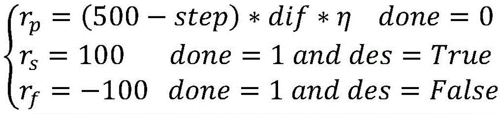
R=rp+rs+rf R=r p +r s +r f
式中,R表示总奖励,rp为无人机正在进行环境探索时执行一个动作的连续奖励,rs为一轮探索结束并且成功飞到目标点的稀疏奖励,rf为一轮探索结束但出现故障没有到达目标点的稀疏奖励;In the formula, R represents the total reward, r p is the continuous reward for performing an action when the UAV is exploring the environment, rs is the sparse reward for completing a round of exploration and successfully flying to the target point, r f is the end of a round of exploration But there is a sparse reward for failing to reach the target point;
步骤(4),设计策略网络和状态价值网络;Step (4), designing strategy network and state value network;
所述策略网络的输入量为多维度特征融合的状态空间S,输出量为无人机要执行的动作的概率向量a_prob,长度为动作空间内动作的个数,根据概率采样选择动作a,转化为无人机的控制量使无人机执行动作;The input of the policy network is the state space S of multi-dimensional feature fusion, the output is the probability vector a_prob of the action to be performed by the drone, and the length is the number of actions in the action space, and the action a is selected according to the probability sampling, and converted Make the drone perform actions for the amount of control of the drone;
所述状态价值网络的输入量为多维度特征融合的状态空间S,输出量为对当前状态的评估V(s);The input of the state value network is the state space S of multi-dimensional feature fusion, and the output is the evaluation V(s) of the current state;
步骤(5),设计临时经验池存储无人机与环境交互时的信息反馈;Step (5), designing a temporary experience pool to store information feedback when the UAV interacts with the environment;
步骤(6),基于离散PPO算法进行深度强化学习网络训练;Step (6), carrying out deep reinforcement learning network training based on the discrete PPO algorithm;
步骤(7),将训练至收敛的策略网络作为无人机的动作决策控制器,实现智能导航。In step (7), the policy network trained to convergence is used as the action decision controller of the UAV to realize intelligent navigation.
在一个实施例中,所述步骤(1),障碍物为同一颜色的长方体,环境有边界,无人机能到的最小边界wsmin=(xmin,ymin,zmin),无人机能到的最大边界wsmax=(xmax,ymax,zmax),(xmin,ymin,zmin)和(xmax,ymax,zmax)均是环境中的坐标点;边界与障碍物用不同颜色的墙体区分。In one embodiment, in step (1), the obstacles are cuboids of the same color, the environment has boundaries, and the minimum boundary ws min = (x min , y min , z min ) that the drone can reach, the drone can reach The maximum boundary ws max = (x max , y max , z max ), (x min , y min , z min ) and (x max , y max , z max ) are coordinate points in the environment; the boundary and the obstacle Differentiate with walls of different colors.
在一个实施例中,所述步骤(2),建立的状态空间如下:In one embodiment, described step (2), the state space of establishment is as follows:
S=(Px,Py,Pz,Ow,Ox,Oy,Oz,L,Cam)S=(P x ,P y ,P z ,O w ,O x ,O y ,O z ,L,Cam)
Px为无人机的x轴方向位置,Py为无人机的y轴方向位置,Pz为无人机的z轴方向位置,满足:P x is the x-axis position of the drone, P y is the y-axis position of the drone, and P z is the z-axis position of the drone, satisfying:
wsmin≤(Px,Py,Pz)≤wsmax ws min ≤(P x ,P y ,P z )≤ws max
Ow、Ox、Oy、Oz即所述四元数,翻滚角roll、俯仰角pitch满足:O w , O x , O y , and O z are the quaternions, and the roll angle roll and pitch angle pitch satisfy:

pitch=asin[2(OwOy-OzOx)]pitch=asin[2(O w O y -O z O x )]
无人机与障碍物的一维距离L的最小值为0,当检测不到前方有障碍物时赋值5;The minimum value of the one-dimensional distance L between the drone and the obstacle is 0, and the value is 5 when no obstacle is detected in front;
所述二维轮廓的状态向量Cam通过如下方式获取:The state vector Cam of the two-dimensional profile is obtained in the following way:
前置摄像头接收到传来的RGB三通道图像数据后,输入到卷积神经网络中进行特征提取,得到状态向量Cam;After the front camera receives the RGB three-channel image data, it is input into the convolutional neural network for feature extraction, and the state vector Cam is obtained;
所述离散动作空间A的动作通过给控制无人机飞行的话题发送改变线速度和角速度的指令来完成。The actions in the discrete action space A are completed by sending commands to change the linear velocity and angular velocity to the topic of controlling the flight of the drone.
在一个实施例中,所述卷积神经网络为三层,第一层网络输入通道数为3,输出通道数为32,卷积核大小为3x3,采样步长为2;卷积结束经过ReLU函数激活,再进行最大池化采样操作,池化尺寸为2x2,处理完后传入第二层网络;第二层网络输入通道数为32,输出通道数为16,卷积核大小为3x3,采样步长为2,卷积结束经过ReLU函数激活;第三层是全连接神经网络,将卷积神经网络得到的结果展开成一维向量,再经过全连接神经网络将结果转换成为一行三列的向量,再经过ReLU函数激活得到状态向量Cam。In one embodiment, the convolutional neural network has three layers, the number of input channels of the first layer network is 3, the number of output channels is 32, the size of the convolution kernel is 3x3, and the sampling step is 2; the convolution is completed through ReLU The function is activated, and then the maximum pooling sampling operation is performed. The pooling size is 2x2. After processing, it is passed to the second layer network; the number of input channels of the second layer network is 32, the number of output channels is 16, and the convolution kernel size is 3x3. The sampling step is 2, and the convolution is activated by the ReLU function; the third layer is a fully connected neural network, which expands the results obtained by the convolutional neural network into a one-dimensional vector, and then converts the result into a row and three columns through the fully connected neural network Vector, and then activated by the ReLU function to obtain the state vector Cam.
在一个实施例中,所述步骤(3)中,当回合结束标志位done为0时,计算rp作为当前奖励:In one embodiment, in the step (3), when the round end flag bit done is 0, calculate r p as the current reward:
rp=(500-step)*dif*ηdone=0r p =(500-step)*dif*ηdone=0
step为训练一轮走的当前步数,步数越多奖励rp越小,目标点的位置为G=(gx,gy,gz),当前位置为cur=(curx,cury,curz),上一个状态的位置为pred=(predx,predy,predz),dif为当前位置与上一个动作的位置相对于目标点的偏移量,等于当前距目标点的距离减去上一个动作距目标点的欧式距离;step is the current number of steps taken in a training round. The more steps, the smaller the reward r p is. The position of the target point is G=(g x , g y , g z ), and the current position is cur=(cur x , cur y ,cur z ), the position of the previous state is pred=(pred x ,pred y ,pred z ), dif is the offset between the current position and the position of the previous action relative to the target point, which is equal to the current distance from the target point Subtract the Euclidean distance from the last action to the target point;
η为超参数,用于调整rp的大小,使得所有奖励的数量级均衡;η is a hyperparameter, which is used to adjust the size of r p so that the order of magnitude of all rewards is balanced;
当done为1并且des为True时,计算rs作为当前奖励:When done is 1 and des is True, compute r s as the current reward:
rs=100done=1 and des=Truer s = 100done = 1 and des = True
des为到达目标点标志位,若无人机当前距目标点的距离小于ε则认为无人机已到达目标点,des为True,不满足条件即为False;des is the flag of reaching the target point. If the current distance between the drone and the target point is less than ε, it is considered that the drone has reached the target point. des is True, and it is False if the condition is not met;
当done为1并且des为False,计算rf作为当前奖励:When done is 1 and des is False, calculate r f as the current reward:
rf=-100done=1 and des=False。r f =-100 done = 1 and des = False.
在一个实施例中,判断回合是否结束标志位done有以下因素:In one embodiment, there are the following factors for judging whether the round end flag is done:
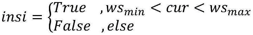
insi代表无人机目前是否在观测空间中,若当前位置cur大于最小边界wsmin并且小于最大边界wsmax,则insi为真;insi represents whether the UAV is currently in the observation space, if the current position cur is greater than the minimum boundary ws min and smaller than the maximum boundary ws max , then insi is true;
clp代表无人机是否非常接近地面,若当前位置的z方向curz小于最小的高度阈值hmin,则clp为真;clp represents whether the UAV is very close to the ground, if the z-direction cur z of the current position is less than the minimum height threshold h min , then clp is true;
flip代表无人机是否发生坠毁,若当前欧拉角eul=(pitch,roll)小于最小的欧拉角阈值eulmin或者大于最大的欧拉角阈值eulmax,则flip为真;flip represents whether the UAV has crashed. If the current Euler angle eul=(pitch,roll) is less than the minimum Euler angle threshold eul min or greater than the maximum Euler angle threshold eul max , then flip is true;
clo代表是否非常靠近障碍物,若雷达读数L小于最小阈值Lmin,则clo为真;clo represents whether it is very close to the obstacle, if the radar reading L is less than the minimum threshold L min , then clo is true;
当insi为假或者其他四个标志有一个为真则done为1,表示一个探索回合结束。When insi is false or one of the other four flags is true, done is 1, indicating that an exploration round is over.
在一个实施例中,所述策略网络包含四层,第一层为输入层,输入个数为11个,第二层为隐藏层,节点数为128个,第三层为隐藏层,节点数为64个,第四层为输出层,节点数为动作空间动作的个数,策略网络的所有隐藏层之间的激活函数均为Tanh激活函数;In one embodiment, the policy network includes four layers, the first layer is an input layer, the number of inputs is 11, the second layer is a hidden layer, and the number of nodes is 128, the third layer is a hidden layer, and the number of nodes is is 64, the fourth layer is the output layer, the number of nodes is the number of actions in the action space, and the activation function between all hidden layers of the strategy network is the Tanh activation function;
所述状态价值网络包含四层,第一层为输入层,输入个数为11个,第二层为隐藏层,节点数为128个,第三层为隐藏层,节点数为64个,第四层为输出层,节点个数为1,代表状态价值网络对当前输入的状态的打分,状态价值网络的所有隐藏层之间的激活函数均为Tanh激活函数。The state value network includes four layers, the first layer is an input layer with 11 inputs, the second layer is a hidden layer with 128 nodes, the third layer is a hidden layer with 64 nodes, and the second layer is a hidden layer with 64 nodes. The fourth layer is the output layer, and the number of nodes is 1, which represents the scoring of the current input state by the state-value network. The activation function between all hidden layers of the state-value network is the Tanh activation function.
在一个实施例中,所述临时经验池还用于计算优势函数,当出现当前步数step超过一轮规定的最大训练步数stepmax,而无人机状态良好仍在探索时,done=0,但此时的状态量并不是终止状态,定义一个变量flag,flag为True表示正常终止,反之表示达到单回合最大步数终止,从而与正常终止进行区分;In one embodiment, the temporary experience pool is also used to calculate the advantage function, when the current number of steps step exceeds the maximum number of training steps step max specified in one round, and the UAV is in good condition and still exploring, done=0 , but the state quantity at this time is not the termination state, define a variable flag, the flag is True to indicate the normal termination, otherwise it means the termination of the maximum number of steps in a single round, so as to distinguish it from the normal termination;
所述无人机与环境交互时的信息反馈为由无人机每回合和环境交互产生的当前状态st、当前采取的动作a、动作对应的概率pθ(at|st)、得到的奖励r、下一时刻的状态st′、flag、done组成的向量。The information feedback when the UAV interacts with the environment is the current state st generated by the interaction between the UAV and the environment each round, the action a currently taken, and the probability p θ ( at |s t ) corresponding to the action, obtained A vector consisting of the reward r of , the state s t ′ at the next moment, flag, and done.
在一个实施例中,所述步骤(6),使用PPO算法进行无人机的避障与导航训练,设定训练的总周期数目N,在每个周期内无人机与环境进行信息交互,根据得到的状态信息st传入策略网络中得到动作的概率,采样得到输出的动作,执行完成动作后获得新的状态信息st′,并判断flag、done的值,将所得值按照顺序存入临时经验池中;每当临时经验池数据存满时,将数据分批取出更新策略网络和状态价值网络,数据利用完后清空临时经验池,重新让无人机探索环境再更新网络,直至网络结构收敛至稳定状态。In one embodiment, the step (6) uses the PPO algorithm to carry out the obstacle avoidance and navigation training of the unmanned aerial vehicle, the total number of training cycles N is set, and the unmanned aerial vehicle and the environment carry out information interaction in each cycle, According to the obtained state information s t is passed into the policy network to obtain the probability of action, the output action is obtained by sampling, and the new state information s t ′ is obtained after the action is executed, and the values of flag and done are judged, and the obtained values are stored in order into the temporary experience pool; whenever the data in the temporary experience pool is full, the data is taken out in batches to update the strategy network and state value network. The network structure converges to a steady state.
在一个实施例中,所述动作决策控制器,传入当前状态信息st,输出动作概率再采样得到动作a,控制无人机执行动作a,直至无人机达到目标点。In one embodiment, the action decision controller inputs the current state information st , outputs the action probability and then samples to obtain the action a, and controls the UAV to execute the action a until the UAV reaches the target point.
本发明与现有技术相比,具体有如下优点:Compared with the prior art, the present invention has the following advantages:
第一,本发明使用多维度特征融合的方式获取状态信息传入强化学习神经网络中,使得无人机可以很大程度利用不同维度环境信息综合决策,从而在避障导航的过程中更加智能化,做出的动作更优。First, the present invention uses multi-dimensional feature fusion to obtain state information and transmit it to the reinforcement learning neural network, so that the UAV can make comprehensive decisions using environmental information in different dimensions to a large extent, thus making it more intelligent in the process of obstacle avoidance navigation , the actions made are better.
第二,本发明建模的仿真环境真实,充分的考虑了无人机在飞行过程中遇到的各种问题并加以处理,对在真实场景中进行无人机强化学习仿真有很强的借鉴意义。Second, the simulation environment of modeling in the present invention is real, fully considers various problems encountered by the UAV during flight and handles them, and has a strong reference for UAV reinforcement learning simulation in real scenes significance.
第三,本发明采用PPO算法的离散形式设计动作空间,设计适当的动作空间使得无人机探索环境时,在不影响控制功能精度降低的前提下,换取解空间维度的压缩以及探索效率的提升,网络更容易收敛。Third, the present invention adopts the discrete form of the PPO algorithm to design the action space. Designing an appropriate action space allows the UAV to explore the environment without affecting the accuracy of the control function, in exchange for the compression of the solution space dimension and the improvement of exploration efficiency. , the network converges more easily.
第四,本发明将经验池拆分,并设计采样概率函数在不同训练阶段对不同采样池进行采样,有效解决在训练初期奖励稀疏训练慢,在训练后期探索效率不足容易过拟合的问题。Fourth, the present invention splits the experience pool, and designs a sampling probability function to sample different sampling pools at different training stages, effectively solving the problems of sparse reward training at the early stage of training, and insufficient exploration efficiency and easy overfitting at the later stage of training.
附图说明Description of drawings
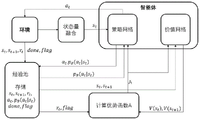
图1为本发明整体原理示意图。Fig. 1 is a schematic diagram of the overall principle of the present invention.
图2为本发明的多维度状态量融合示意图。FIG. 2 is a schematic diagram of multi-dimensional state quantity fusion in the present invention.
图3为本发明的策略网络结构图。Fig. 3 is a structural diagram of the policy network of the present invention.
图4为本发明的状态价值网络结构图。Fig. 4 is a structure diagram of the state value network of the present invention.
图5、图6、图7为三次实验结果示意图。Figure 5, Figure 6, and Figure 7 are schematic diagrams of the three experimental results.
图8为三次实验无人机对应的飞行轨迹图。Figure 8 is the flight trajectory diagram corresponding to the three experimental UAVs.
具体实施方式Detailed ways
下面结合附图和实施例详细说明本发明的实施方式。The implementation of the present invention will be described in detail below in conjunction with the drawings and examples.
如前所述,现有的无人机深度强化学习避障导航方法往往依赖于已知的仿真环境,而现实往往是未知的,因此没有太多实际意义。并且,基于未知环境的仿真中无人机无法充分的感知不同状态下的环境信息,因此无法在具体状态下做出及时准确的反应,表现效果较差,强化学习在三维空间中训练会出现网络训练效率慢甚至不收敛的情况。As mentioned earlier, the existing UAV deep reinforcement learning obstacle avoidance navigation methods often rely on the known simulation environment, and the reality is often unknown, so there is not much practical significance. Moreover, in the simulation based on the unknown environment, the UAV cannot fully perceive the environmental information in different states, so it cannot make timely and accurate responses in specific states, and the performance effect is poor. When reinforcement learning is trained in three-dimensional space, the network will appear The training efficiency is slow or even does not converge.
为解决这些问题,本发明提出一种基于强化学习的无人机避障导航方法,在三维环境中进行仿真实验,融合二维图像信息和一维状态信息输入到强化学习网络中训练,使无人机可以充分的探测周围环境,并通过设计离散动作空间、拆分经验池按概率采样、加入策略熵等方式优化网络收敛速度,进而在特定的状态下做出更优的动作,从而实现良好的导航效果。In order to solve these problems, the present invention proposes a UAV obstacle-avoidance navigation method based on reinforcement learning. Simulation experiments are carried out in a three-dimensional environment, and two-dimensional image information and one-dimensional state information are input into the reinforcement learning network for training, so that no The human-machine can fully detect the surrounding environment, and optimize the network convergence speed by designing discrete action spaces, splitting the experience pool to sample by probability, and adding policy entropy, and then make better actions in specific states, so as to achieve good navigation effect.
为使本领域技术人员更好地理解本发明的技术方案,下面结合具体实施方式对本发明作进一步详细描述。In order to enable those skilled in the art to better understand the technical solutions of the present invention, the present invention will be further described in detail below in conjunction with specific embodiments.
本发明是一种基于深度强化学习的无人机智能导航方法,其原理如图1所示,建立无人机的仿真环境,智能体由策略网络和状态价值网络组成,智能体接收到环境的状态量后首先进行将不同维度的状态信息进行融合,将融合后的状态信息st传给策略网络,策略网络根据输入的状态量计算出动作空间中每一个动作发生的概率pθ(at|st),进行采样得出选择的动作a,将得出的动作发送给智能体控制层使智能体做出相应动作,动作完成后感知最新的状态st+1并计算获得的奖励rt和标志位done,flag,将上面得到的数据序列[st,a,pθ(at|st),r,st+1,done,flag]存入经验池内,经验池存满后分批选取数据。将st,st+1传入价值网络计算出两个状态的价值估计V(st),V(st+1),结合经验池中的rt,flag计算优势函数A,将计算完的优势函数和pθ(at|st)传给策略网络进行参数更新,将计算完的优势函数和V(st)传给价值网络进行参数更新,直到网络收敛。收敛的策略网络可指导智能体在每个状态下做出最优的策略,从而实现避障导航。The present invention is an intelligent navigation method for UAVs based on deep reinforcement learning. Its principle is shown in Figure 1. A simulation environment for UAVs is established. The intelligent body is composed of a strategy network and a state value network. After the state quantity, the state information of different dimensions is first fused, and the fused state information s t is passed to the policy network, and the policy network calculates the probability of each action in the action space p θ (a t |s t ), perform sampling to obtain the selected action a, and send the obtained action to the agent control layer to make the agent make the corresponding action. After the action is completed, perceive the latest state s t+1 and calculate the obtained reward r t and the flag bits done,flag, store the data sequence [s t ,a,p θ (a t |s t ),r,s t+1 ,done,flag] obtained above into the experience pool, and the experience pool is full Then select data in batches. Pass st , st +1 into the value network to calculate the value estimates V(s t ), V(s t+1 ) of the two states, combine r t and flag in the experience pool to calculate the advantage function A, and calculate The completed advantage function and p θ ( at |s t ) are passed to the strategy network for parameter update, and the calculated advantage function and V(s t ) are passed to the value network for parameter update until the network converges. The convergent policy network can guide the agent to make the optimal policy in each state, so as to realize obstacle avoidance navigation.
具体地,本发明包括如下步骤:Specifically, the present invention comprises the following steps:
步骤一:在三维仿真环境中建立无人机模型,并生成障碍物和目标点。Step 1: Establish the UAV model in the 3D simulation environment, and generate obstacles and target points.
本发明中,采用四旋翼无人机,无人机上安装有机载前置摄像头和激光雷达,前置摄像头主要用于感知障碍物的二维轮廓,激光雷达主要用于感知无人机与障碍物的一维距离L。In the present invention, a four-rotor UAV is adopted, and an on-board front camera and a laser radar are installed on the UAV. The one-dimensional distance L of the object.
示例地,障碍物为同一颜色的长方体,环境有边界,可用与障碍物不同颜色的墙体区分。无人机能到的最小边界wsmin=(xmin,ymin,zmin),无人机能到的最大边界wsmax=(xmax,ymax,zmax),(xmin,ymin,zmin)和(xmax,ymax,zmax)均是环境中的坐标点。For example, the obstacle is a cuboid of the same color, and the environment has a boundary, which can be distinguished from the obstacle by a wall of a different color. The minimum boundary ws min that the UAV can reach = (x min , y min , z min ), the maximum boundary ws max that the UAV can reach = (x max , y max , z max ), (x min , y min , z min ) and (x max , y max , z max ) are coordinate points in the environment.
本发明的实施例中,环境大小为长宽为10m,高为6m的立方体。In the embodiment of the present invention, the size of the environment is a cube with a length and width of 10 m and a height of 6 m.
在训练开始前需要初始化无人机前置摄像头和激光雷达,保证可以正确接收到数据,在环境中随机生成无人机的初始位置,无人机初始状态为着陆状态,给/takeoff话题发送指令即可起飞。Before the training starts, the front camera and lidar of the drone need to be initialized to ensure that the data can be received correctly, and the initial position of the drone is randomly generated in the environment. The initial state of the drone is the landing state, and the command is sent to the /takeoff topic Ready to fly.
步骤二:设计多维度特征融合的状态空间S和离散动作空间A。Step 2: Design a state space S and a discrete action space A for multi-dimensional feature fusion.
参考图2,建立的状态空间S如下:Referring to Figure 2, the established state space S is as follows:
S=(Px,Py,Pz,Ow,Ox,Oy,Oz,L,Cam)S=(P x ,P y ,P z ,O w ,O x ,O y ,O z ,L,Cam)
Px为无人机的x轴方向位置,Py为无人机的y轴方向位置,Pz为无人机的z轴方向位置,需满足:P x is the position of the drone in the x-axis direction, P y is the position in the y-axis direction of the drone, and P z is the position in the z-axis direction of the drone, which must meet:
wsmin≤(Px,Py,Pz)≤wsmax ws min ≤(P x ,P y ,P z )≤ws max
即,保证无人机在有限空间内飞行。That is, to ensure that the drone flies in a limited space.
四元数Ow、Ox、Oy、Oz用来计算无人机当前飞行状态的俯仰角pitch和翻滚角roll:The quaternions O w , O x , O y , and O z are used to calculate the pitch angle pitch and roll angle roll of the drone's current flight state:

pitch=asin[2(OwOy-OzOx)]pitch=asin[2(O w O y -O z O x )]
无人机与障碍物的一维距离L通过激光雷达传感器的读数获取,其最小值为0,当检测不到前方有障碍物时赋值5。The one-dimensional distance L between the UAV and the obstacle is obtained through the reading of the lidar sensor, and its minimum value is 0. When no obstacle is detected in front, it is assigned a value of 5.
Cam为二维轮廓的状态向量,通过如下方式获取:Cam is the state vector of the two-dimensional contour, obtained by the following method:
前置摄像头接收到传来的RGB三通道图像数据(本实施例中,其尺寸为640x360x3)后,输入到卷积神经网络中进行特征提取。After the front camera receives the transmitted RGB three-channel image data (in this embodiment, its size is 640x360x3), it is input into the convolutional neural network for feature extraction.
本实施例中,卷积神经网络为三层,第一层网络输入通道数为3,输出通道数为32,卷积核大小为3x3,采样步长为2。卷积结束经过ReLU函数激活,再进行最大池化采样操作,池化尺寸为2x2,处理完后传入第二层网络。第二层网络输入通道数为32,输出通道数为16,卷积核大小为3x3,采样步长为2,卷积结束经过ReLU函数激活。第三层是全连接神经网络,将卷积神经网络得到的结果展开成一维向量,再经过全连接神经网络将结果转换成为一行三列的向量,再经过ReLU函数激活即得到状态向量Cam。In this embodiment, the convolutional neural network has three layers, the number of input channels of the first layer network is 3, the number of output channels is 32, the size of the convolution kernel is 3x3, and the sampling step is 2. At the end of the convolution, it is activated by the ReLU function, and then the maximum pooling sampling operation is performed. The pooling size is 2x2, and it is passed to the second layer network after processing. The number of input channels of the second layer network is 32, the number of output channels is 16, the size of the convolution kernel is 3x3, the sampling step is 2, and the convolution is activated by the ReLU function. The third layer is a fully connected neural network, which expands the result obtained by the convolutional neural network into a one-dimensional vector, and then converts the result into a vector with one row and three columns through the fully connected neural network, and then activates the state vector Cam through the ReLU function.
本发明动作空间即为离散动作空间A,分别为前进、后退,左转、右转、升高、降落,通过给控制无人机飞行的话题发送改变线速度和角速度的指令来完成。示例地,每一个动作的执行时间T可以设定为0.3s。The action space of the present invention is the discrete action space A, which is respectively forward, backward, left turn, right turn, elevation, and landing, and is completed by sending commands to change the linear velocity and angular velocity to the topic of controlling the flight of the drone. For example, the execution time T of each action can be set to 0.3s.
步骤三:设计基于欧式距离的奖励函数。Step 3: Design a reward function based on Euclidean distance.
R=rp+rs+rf R=r p +r s +r f
式中,R表示总奖励,rp为无人机正在进行环境探索时执行一个动作的连续奖励,当回合结束标志位done为0时,计算rp作为当前奖励。step为训练一轮走的当前步数,步数越多奖励rp越小,目标点的位置为G=(gx,gy,gz),当前位置为cur=(curx,cury,curz),上一个状态的位置为pred=(predx,predy,predz),dif为当前位置与上一个动作的位置相对于目标点的偏移量,等于当前距目标点的距离减去上一个动作距目标点的距离,这里的距离指欧式距离。In the formula, R represents the total reward, and r p is the continuous reward for performing an action when the UAV is exploring the environment. When the done flag at the end of the round is 0, r p is calculated as the current reward. step is the current number of steps taken in a training round. The more steps, the smaller the reward r p is. The position of the target point is G=(g x , g y , g z ), and the current position is cur=(cur x , cur y ,cur z ), the position of the previous state is pred=(pred x ,pred y ,pred z ), dif is the offset between the current position and the position of the previous action relative to the target point, which is equal to the current distance from the target point Subtract the distance from the last action to the target point, where the distance refers to the Euclidean distance.

η为超参数,用于调整rp的大小,使得所有奖励的数量级均衡。η is a hyperparameter, which is used to adjust the size of r p so that the order of magnitude of all rewards is balanced.
rs为一轮探索结束并且成功飞到目标点的稀疏奖励,des为到达目标点标志位,满足:r s is the sparse reward for successfully flying to the target point at the end of a round of exploration, des is the flag for reaching the target point, and it satisfies:

若无人机当前距目标点的距离小于ε则认为无人机已到达目标点,des为True,不满足条件即为False。当done为1并且des为True时,计算rs作为当前奖励。If the current distance between the UAV and the target point is less than ε, it is considered that the UAV has reached the target point, des is True, and False if the condition is not met. When done is 1 and des is True, compute r s as the current reward.
rf为一轮探索结束但出现故障没有到达目标点的稀疏奖励,此时done为1并且des为False。r f is the sparse reward that a round of exploration ends but fails to reach the target point. At this time, done is 1 and des is False.
判断回合是否结束标志位done有以下因素:The following factors are used to determine whether the round end flag is done:
insi代表无人机目前是否在观测空间中,若当前位置cur大于观测空间最小值(即最小边界)wsmin并且小于观测空间最大值(即最大边界)wsmax,则insi为真;insi represents whether the UAV is currently in the observation space. If the current position cur is greater than the minimum value of the observation space (ie, the minimum boundary) ws min and smaller than the maximum value of the observation space (ie, the maximum boundary) ws max , then insi is true;
clp代表无人机是否非常接近地面,若当前位置的z方向curz小于最小的高度阈值hmin,则clp为真;clp represents whether the UAV is very close to the ground, if the z-direction cur z of the current position is less than the minimum height threshold h min , then clp is true;

flip代表无人机是否发生坠毁,若当前欧拉角eul=(pitch,roll)小于最小的欧拉角阈值eulmin或者大于最大的欧拉角阈值eulmax,则flip为真;flip represents whether the UAV has crashed. If the current Euler angle eul=(pitch,roll) is less than the minimum Euler angle threshold eul min or greater than the maximum Euler angle threshold eul max , then flip is true;

clo代表是否非常靠近障碍物,若雷达读数L小于最小阈值Lmin,则clo为真。clo represents whether it is very close to an obstacle, and if the radar reading L is smaller than the minimum threshold L min , then clo is true.

当insi为假或者其他四个标志有一个为真则done为1,表示一个探索回合结束。When insi is false or one of the other four flags is true, done is 1, indicating that an exploration round is over.

步骤四:设计策略网络和状态价值网络。Step 4: Design policy network and state value network.
强化学习PPO算法的网络包括策略网络和状态价值网络。The network of reinforcement learning PPO algorithm includes policy network and state value network.
策略网络的输入量是多维度的状态量S=(Px,Py,Pz,Ow,Ox,Oy,Oz,L,Cam),输出量为无人机要执行的动作的概率向量a_prob,长度为动作空间内动作的个数,如图3所示,根据概率采样选择动作a,转化为无人机的控制量使无人机执行动作。The input of the policy network is the multi-dimensional state quantity S=(P x , P y , P z , O w , O x , O y , O z , L, Cam), and the output is the action to be performed by the drone The probability vector a_prob, whose length is the number of actions in the action space, as shown in Figure 3, selects the action a according to the probability sampling, and converts it into the control amount of the drone to make the drone execute the action.
示例地,策略网络包含四层,第一层为输入层,输入个数为11个,第二层为隐藏层,节点数为128个,第三层为隐藏层,节点数为64个,第四层为输出层,节点数为动作空间动作的个数。For example, the policy network contains four layers, the first layer is the input layer, the number of inputs is 11, the second layer is the hidden layer, the number of nodes is 128, the third layer is the hidden layer, the number of nodes is 64, the The fourth layer is the output layer, and the number of nodes is the number of actions in the action space.
策略网络的所有隐藏层之间的激活函数均为Tanh激活函数,生成网络时对所有网络层进行正交初始化操作,用均值为0,标准差为1的高斯分布初始化权重矩阵,对这个权重矩阵进行奇异值分解,得到两个正交矩阵,取其中之一作为该层神经网络的权重矩阵。The activation function between all hidden layers of the strategy network is the Tanh activation function. When generating the network, perform an orthogonal initialization operation on all network layers, and initialize the weight matrix with a Gaussian distribution with a mean value of 0 and a standard deviation of 1. For this weight matrix Perform singular value decomposition to obtain two orthogonal matrices, and take one of them as the weight matrix of the neural network of this layer.
策略网络最终要最大化的目标函数为:The objective function to be maximized by the policy network is:

式中pθ(at|st)表示新策略,


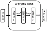
状态价值函数估计网络输入量同样为状态量S,输出量为对当前状态的评估V(s)。如图4所示,状态价值网络同样包含四层,第一层为输入层,输入个数为11个,第二层为隐藏层,节点数为128个,第三层为隐藏层,节点数为64个,第四层为输出层,节点数为1,代表状态价值网络对当前输入的状态的打分。状态价值网络的所有隐藏层之间的激活函数均为Tanh激活函数,生成网络时对所有网络层进行正交初始化操作。The input of state value function estimation network is also the state quantity S, and the output quantity is the evaluation of the current state V(s). As shown in Figure 4, the state value network also includes four layers, the first layer is the input layer, the number of inputs is 11, the second layer is the hidden layer, the number of nodes is 128, the third layer is the hidden layer, the number of nodes The number of nodes is 64, the fourth layer is the output layer, and the number of nodes is 1, which represents the scoring of the current input state by the state value network. The activation function between all hidden layers of the state value network is the Tanh activation function, and the orthogonal initialization operation is performed on all network layers when generating the network.
采用误差平方的形式和梯度下降法更新状态价值函数:The state-value function is updated in the form of the square of the error and the gradient descent method:

步骤五:设计临时经验池存储交互信息。Step 5: Design a temporary experience pool to store interaction information.
本发明的临时经验池还用于计算优势函数,在本训练框架中,会出现当前步数step超过一轮规定的最大训练步数stepmax时,无人机状态良好仍在探索的情况,此时done=0。此时的状态量S并不是终止状态,为和正常终止做区分,定义一个变量flag,flag为True表示正常终止,反之表示达到单回合最大步数终止。The temporary experience pool of the present invention is also used to calculate the advantage function. In this training framework, when the current number of steps step exceeds the maximum number of training steps step max specified in one round, the drone is in good condition and is still exploring. When done=0. The state quantity S at this time is not the termination state. In order to distinguish it from normal termination, a variable flag is defined. If the flag is True, it means normal termination, otherwise it means that the maximum number of steps in a single round is reached and terminated.
本发明中,无人机与环境交互时的信息反馈,由无人机每回合和环境交互产生的当前状态st、当前采取的动作a、某状态下选择相应动作对应的概率pθ(at|st)、得到的奖励r、下一时刻的状态st′、flag、done组成,具体形式为[st,a,pθ(at|st),r,st+1,flag,done]。In the present invention, the information feedback when the UAV interacts with the environment includes the current state st generated by the interaction between the UAV and the environment each round, the current action a, and the probability p θ (a t |s t ), the obtained reward r, the state at the next moment s t ′, flag, done, the specific form is [s t ,a,p θ (a t |s t ),r,s t+1 ,flag,done].
将经验池分为正经验池和普通经验池,正经验池存放r大于零的训练样本,普通经验池存放所有样本,算法依据采样概率
步骤六:基于PPO算法进行强化学习网络训练。Step 6: Perform reinforcement learning network training based on the PPO algorithm.
优势函数At(st,at)的计算方式采用GAE形式:The calculation method of the advantage function A t (s t , at ) adopts the GAE form:

式中γ为折扣率,λ为调整因子,越接近1方差越大偏差越小,接近0反之。V(st)为价值评价网络当前输出的值。In the formula, γ is the discount rate, and λ is the adjustment factor. The closer to 1, the greater the variance and the smaller the deviation, and vice versa. V(s t ) is the value currently output by the value evaluation network.
为区分flag为True或False,即无人机训练正常结束和异常截断,对优势函数

flag为True时表明智能体正常结束探索,没有下一个状态V(st+1)。When the flag is True, it indicates that the agent ends the exploration normally, and there is no next state V(s t+1 ).
为增加算法的探索能力,在策略网络的目标函数中增加一项策略熵:In order to increase the exploration ability of the algorithm, a policy entropy is added to the objective function of the policy network:
J(θ)=J(πθ)+entr*coefJ(θ)=J(π θ )+entr*coef
式中entr为策略熵,coef为系数。In the formula, entr is the strategy entropy, and coef is the coefficient.
使用PPO算法进行无人机的避障与导航训练,设定训练的总周期数目N,在每个周期内无人机与环境进行信息交互,根据得到的状态信息st传入策略网络中得到动作的概率,采样得到输出的动作,执行完成动作后获得新的状态信息st+1,并判断flag、done等变量的值,将这些值按照顺序存入经验池当中;每当经验池数据存满时,将数据分批取出计算梯度更新策略网络和状态价值网络,经验池数据利用完后清空经验池重新让无人机探索环境再更新网络,直至网络结构收敛至稳定状态。Use the PPO algorithm to carry out obstacle avoidance and navigation training for UAVs. Set the total number of training cycles N. In each cycle, the UAV interacts with the environment. According to the obtained state information s t , it is passed into the strategy network to obtain The probability of the action, the output action is obtained by sampling, and the new state information st +1 is obtained after the action is executed, and the values of variables such as flag and done are judged, and these values are stored in the experience pool in order; each time the experience pool data When the storage is full, the data is taken out in batches to calculate the gradient update strategy network and the state value network. After the experience pool data is used, the experience pool is cleared and the drone is allowed to explore the environment and then update the network until the network structure converges to a stable state.
步骤七:无人机智能导航实现。Step 7: UAV intelligent navigation realization.
将训练至收敛的策略网络直接当作无人机的动作决策控制器,传入当前状态信息st,输出动作概率再采样得到动作a,控制无人机执行动作a,直至无人机达到目标点。图5、图6、图7分别为三次仿真实验,在面对障碍物时,策略网络输出动作决策指导无人机避开障碍物并抵达目标点附近。四周白色部分为墙体,里边黑色有阴影的立方体为障碍物,无人机前端发出的四条白线为前置摄像机视野范围。图8展示了三次实验中无人机的飞行轨迹,可用看出,三次实验中无人机在躲避了障碍物后,都顺利到达目标点附近。The policy network trained to convergence is directly used as the action decision controller of the UAV, and the current state information s t is passed in, the output action probability is then sampled to obtain the action a, and the UAV is controlled to execute the action a until the UAV reaches the goal point. Figure 5, Figure 6, and Figure 7 are three simulation experiments respectively. When facing obstacles, the policy network outputs action decisions to guide the UAV to avoid obstacles and reach the vicinity of the target point. The white part around is the wall, the black and shadowed cube inside is the obstacle, and the four white lines from the front of the drone are the field of view of the front camera. Figure 8 shows the flight trajectories of the UAV in the three experiments. It can be seen that in the three experiments, the UAV successfully arrived near the target point after avoiding obstacles.
Claims (10)

Priority Applications (1)
| Application Number | Priority Date | Filing Date | Title |
|---|---|---|---|
| CN202210881739.2A CN115373415B (en) | 2022-07-26 | 2022-07-26 | A UAV intelligent navigation method based on deep reinforcement learning |
Applications Claiming Priority (1)
| Application Number | Priority Date | Filing Date | Title |
|---|---|---|---|
| CN202210881739.2A CN115373415B (en) | 2022-07-26 | 2022-07-26 | A UAV intelligent navigation method based on deep reinforcement learning |
Publications (2)
| Publication Number | Publication Date |
|---|---|
| CN115373415A true CN115373415A (en) | 2022-11-22 |
| CN115373415B CN115373415B (en) | 2025-02-07 |
Family
ID=84063180
Family Applications (1)
| Application Number | Title | Priority Date | Filing Date |
|---|---|---|---|
| CN202210881739.2A Active CN115373415B (en) | 2022-07-26 | 2022-07-26 | A UAV intelligent navigation method based on deep reinforcement learning |
Country Status (1)
| Country | Link |
|---|---|
| CN (1) | CN115373415B (en) |
Cited By (7)
| Publication number | Priority date | Publication date | Assignee | Title |
|---|---|---|---|---|
| CN115860107A (en) * | 2023-01-30 | 2023-03-28 | 武汉大学 | Multi-machine search method and system based on multi-agent deep reinforcement learning |
| CN116225055A (en) * | 2023-01-06 | 2023-06-06 | 南京航空航天大学 | An Algorithm for UAV Autonomous Track Planning Based on State Decomposition in Complex Environment |
| CN116242364A (en) * | 2023-03-09 | 2023-06-09 | 西安电子科技大学 | A Multi-UAV Intelligent Navigation Method Based on Deep Reinforcement Learning |
| CN117873089A (en) * | 2024-01-10 | 2024-04-12 | 南京理工大学 | A cooperative path planning method for multiple mobile robots based on clustering PPO algorithm |
| CN118089794A (en) * | 2024-04-26 | 2024-05-28 | 北京航宇测通电子科技有限公司 | Simulation method for self-adaptive multi-information integrated navigation based on multi-source information |
| CN119937590A (en) * | 2025-01-22 | 2025-05-06 | 哈尔滨工业大学 | A method for autonomous visual navigation and obstacle avoidance of quadrotor drones based on deep reinforcement learning |
| CN120848530A (en) * | 2025-09-23 | 2025-10-28 | 青岛理工大学 | Dynamic obstacle avoidance control method and system for mobile robots based on reinforcement learning |
Citations (9)
| Publication number | Priority date | Publication date | Assignee | Title |
|---|---|---|---|---|
| CN106355151A (en) * | 2016-08-30 | 2017-01-25 | 电子科技大学 | Recognition method, based on deep belief network, of three-dimensional SAR images |
| CN107492095A (en) * | 2017-08-02 | 2017-12-19 | 西安电子科技大学 | Medical image pulmonary nodule detection method based on deep learning |
| US20180186452A1 (en) * | 2017-01-04 | 2018-07-05 | Beijing Deephi Technology Co., Ltd. | Unmanned Aerial Vehicle Interactive Apparatus and Method Based on Deep Learning Posture Estimation |
| CN110873879A (en) * | 2018-08-30 | 2020-03-10 | 沈阳航空航天大学 | Device and method for deep fusion of characteristics of multi-source heterogeneous sensor |
| CN113485441A (en) * | 2021-08-03 | 2021-10-08 | 国网江苏省电力有限公司泰州供电分公司 | Distribution network inspection method combining unmanned aerial vehicle high-precision positioning and visual tracking technology |
| JP6950117B1 (en) * | 2020-04-30 | 2021-10-13 | 楽天グループ株式会社 | Learning device, information processing device, and trained control model |
| CN114089776A (en) * | 2021-11-09 | 2022-02-25 | 南京航空航天大学 | Unmanned aerial vehicle obstacle avoidance method based on deep reinforcement learning |
| CN114355980A (en) * | 2022-01-06 | 2022-04-15 | 上海交通大学宁波人工智能研究院 | Four-rotor unmanned aerial vehicle autonomous navigation method and system based on deep reinforcement learning |
| US20220169381A1 (en) * | 2020-11-30 | 2022-06-02 | Saudi Arabian Oil Company | Deep learning-based localization of uavs with respect to nearby pipes |
-
2022
- 2022-07-26 CN CN202210881739.2A patent/CN115373415B/en active Active
Patent Citations (9)
| Publication number | Priority date | Publication date | Assignee | Title |
|---|---|---|---|---|
| CN106355151A (en) * | 2016-08-30 | 2017-01-25 | 电子科技大学 | Recognition method, based on deep belief network, of three-dimensional SAR images |
| US20180186452A1 (en) * | 2017-01-04 | 2018-07-05 | Beijing Deephi Technology Co., Ltd. | Unmanned Aerial Vehicle Interactive Apparatus and Method Based on Deep Learning Posture Estimation |
| CN107492095A (en) * | 2017-08-02 | 2017-12-19 | 西安电子科技大学 | Medical image pulmonary nodule detection method based on deep learning |
| CN110873879A (en) * | 2018-08-30 | 2020-03-10 | 沈阳航空航天大学 | Device and method for deep fusion of characteristics of multi-source heterogeneous sensor |
| JP6950117B1 (en) * | 2020-04-30 | 2021-10-13 | 楽天グループ株式会社 | Learning device, information processing device, and trained control model |
| US20220169381A1 (en) * | 2020-11-30 | 2022-06-02 | Saudi Arabian Oil Company | Deep learning-based localization of uavs with respect to nearby pipes |
| CN113485441A (en) * | 2021-08-03 | 2021-10-08 | 国网江苏省电力有限公司泰州供电分公司 | Distribution network inspection method combining unmanned aerial vehicle high-precision positioning and visual tracking technology |
| CN114089776A (en) * | 2021-11-09 | 2022-02-25 | 南京航空航天大学 | Unmanned aerial vehicle obstacle avoidance method based on deep reinforcement learning |
| CN114355980A (en) * | 2022-01-06 | 2022-04-15 | 上海交通大学宁波人工智能研究院 | Four-rotor unmanned aerial vehicle autonomous navigation method and system based on deep reinforcement learning |
Non-Patent Citations (3)
| Title |
|---|
| WANG, GZ等: "Collision Detection and Avoidance for Multi-UAV based on Deep Reinforcement Learning", 2021 PROCEEDINGS OF THE 40TH CHINESE CONTROL CONFERENCE (CCC), 1 January 2021 (2021-01-01) * |
| 何金;丁勇;杨勇;黄鑫城;: "未知环境下基于PF-DQN的无人机路径规划", 兵工自动化, no. 09, 9 September 2020 (2020-09-09) * |
| 顾江涛;胡新平;: "基于深度强化学习的无人机飞行路线规划", 计算机与数字工程, no. 06, 20 June 2020 (2020-06-20) * |
Cited By (9)
| Publication number | Priority date | Publication date | Assignee | Title |
|---|---|---|---|---|
| CN116225055A (en) * | 2023-01-06 | 2023-06-06 | 南京航空航天大学 | An Algorithm for UAV Autonomous Track Planning Based on State Decomposition in Complex Environment |
| CN115860107A (en) * | 2023-01-30 | 2023-03-28 | 武汉大学 | Multi-machine search method and system based on multi-agent deep reinforcement learning |
| CN116242364A (en) * | 2023-03-09 | 2023-06-09 | 西安电子科技大学 | A Multi-UAV Intelligent Navigation Method Based on Deep Reinforcement Learning |
| CN117873089A (en) * | 2024-01-10 | 2024-04-12 | 南京理工大学 | A cooperative path planning method for multiple mobile robots based on clustering PPO algorithm |
| CN118089794A (en) * | 2024-04-26 | 2024-05-28 | 北京航宇测通电子科技有限公司 | Simulation method for self-adaptive multi-information integrated navigation based on multi-source information |
| CN118089794B (en) * | 2024-04-26 | 2024-07-09 | 北京航宇测通电子科技有限公司 | Simulation method for self-adaptive multi-information integrated navigation based on multi-source information |
| CN119937590A (en) * | 2025-01-22 | 2025-05-06 | 哈尔滨工业大学 | A method for autonomous visual navigation and obstacle avoidance of quadrotor drones based on deep reinforcement learning |
| CN119937590B (en) * | 2025-01-22 | 2025-10-28 | 哈尔滨工业大学 | Four-rotor unmanned aerial vehicle autonomous vision navigation obstacle avoidance method based on deep reinforcement learning |
| CN120848530A (en) * | 2025-09-23 | 2025-10-28 | 青岛理工大学 | Dynamic obstacle avoidance control method and system for mobile robots based on reinforcement learning |
Also Published As
| Publication number | Publication date |
|---|---|
| CN115373415B (en) | 2025-02-07 |
Similar Documents
| Publication | Publication Date | Title |
|---|---|---|
| CN115373415A (en) | Unmanned aerial vehicle intelligent navigation method based on deep reinforcement learning | |
| CN111123963B (en) | Autonomous Navigation System and Method in Unknown Environment Based on Reinforcement Learning | |
| CN113093802B (en) | Unmanned aerial vehicle maneuver decision method based on deep reinforcement learning | |
| CN113741533B (en) | An intelligent decision-making system for drones based on imitation learning and reinforcement learning | |
| CN114089776B (en) | A UAV obstacle avoidance method based on deep reinforcement learning | |
| CN110806756B (en) | Unmanned aerial vehicle autonomous guidance control method based on DDPG | |
| CN116679719A (en) | Unmanned vehicle self-adaptive path planning method based on dynamic window method and near-end strategy | |
| CN115185288B (en) | Unmanned aerial vehicle layered flight decision method based on SAC algorithm | |
| CN115033022B (en) | Expert-based landing method for DDPG drones for mobile platforms | |
| CN116242364A (en) | A Multi-UAV Intelligent Navigation Method Based on Deep Reinforcement Learning | |
| CN110531786B (en) | Unmanned aerial vehicle maneuvering strategy autonomous generation method based on DQN | |
| CN110134140A (en) | A kind of unmanned plane paths planning method based on potential function award DQN under the unknown continuous state of environmental information | |
| CN113671825B (en) | Maneuvering intelligent decision-avoiding missile method based on reinforcement learning | |
| CN113848974A (en) | Aircraft trajectory planning method and system based on deep reinforcement learning | |
| CN114518770A (en) | Unmanned aerial vehicle path planning method integrating potential field and deep reinforcement learning | |
| CN114609925B (en) | Training method of underwater exploration strategy model and underwater exploration method of bionic machine fish | |
| CN112114592A (en) | Method for realizing autonomous crossing of movable frame-shaped barrier by unmanned aerial vehicle | |
| CN114967721B (en) | Unmanned aerial vehicle self-service path planning and obstacle avoidance strategy method based on DQ-CapsNet | |
| CN118034331A (en) | Autonomous navigation decision-making method for UAV based on state memory reinforcement learning | |
| CN117784812A (en) | UAV autonomous flight decision-making method based on evolution-guided deep reinforcement learning | |
| CN117193355B (en) | A Deep Reinforcement Learning-Based Autonomous Navigation and Obstacle Avoidance Method for Unmanned Aerial Vehicles | |
| CN118502457A (en) | Track planning method, device and autonomous system | |
| CN115357042B (en) | Conical obstacle avoidance method and system for cruise missile formation based on two-hop network | |
| CN119717842A (en) | Method and system for collaborative formation of multiple unmanned aerial vehicles in complex dynamic environment based on MASAC algorithm | |
| CN113093803B (en) | Unmanned aerial vehicle air combat motion control method based on E-SAC algorithm |
Legal Events
| Date | Code | Title | Description |
|---|---|---|---|
| PB01 | Publication | ||
| PB01 | Publication | ||
| SE01 | Entry into force of request for substantive examination | ||
| SE01 | Entry into force of request for substantive examination | ||
| GR01 | Patent grant | ||
| GR01 | Patent grant |