CN114861882B - A CO2 spatio-temporal distribution reconstruction method and system - Google Patents
A CO2 spatio-temporal distribution reconstruction method and system Download PDFInfo
- Publication number
- CN114861882B CN114861882B CN202210490951.6A CN202210490951A CN114861882B CN 114861882 B CN114861882 B CN 114861882B CN 202210490951 A CN202210490951 A CN 202210490951A CN 114861882 B CN114861882 B CN 114861882B
- Authority
- CN
- China
- Prior art keywords
- neural network
- data
- network model
- deep neural
- environment
- Prior art date
- Legal status (The legal status is an assumption and is not a legal conclusion. Google has not performed a legal analysis and makes no representation as to the accuracy of the status listed.)
- Active
Links
Images


Classifications
-
- G—PHYSICS
- G06—COMPUTING OR CALCULATING; COUNTING
- G06N—COMPUTING ARRANGEMENTS BASED ON SPECIFIC COMPUTATIONAL MODELS
- G06N3/00—Computing arrangements based on biological models
- G06N3/02—Neural networks
- G06N3/04—Architecture, e.g. interconnection topology
- G06N3/045—Combinations of networks
-
- G—PHYSICS
- G06—COMPUTING OR CALCULATING; COUNTING
- G06F—ELECTRIC DIGITAL DATA PROCESSING
- G06F16/00—Information retrieval; Database structures therefor; File system structures therefor
- G06F16/20—Information retrieval; Database structures therefor; File system structures therefor of structured data, e.g. relational data
- G06F16/21—Design, administration or maintenance of databases
- G06F16/211—Schema design and management
- G06F16/212—Schema design and management with details for data modelling support
-
- G—PHYSICS
- G06—COMPUTING OR CALCULATING; COUNTING
- G06N—COMPUTING ARRANGEMENTS BASED ON SPECIFIC COMPUTATIONAL MODELS
- G06N3/00—Computing arrangements based on biological models
- G06N3/02—Neural networks
- G06N3/08—Learning methods
-
- Y—GENERAL TAGGING OF NEW TECHNOLOGICAL DEVELOPMENTS; GENERAL TAGGING OF CROSS-SECTIONAL TECHNOLOGIES SPANNING OVER SEVERAL SECTIONS OF THE IPC; TECHNICAL SUBJECTS COVERED BY FORMER USPC CROSS-REFERENCE ART COLLECTIONS [XRACs] AND DIGESTS
- Y02—TECHNOLOGIES OR APPLICATIONS FOR MITIGATION OR ADAPTATION AGAINST CLIMATE CHANGE
- Y02A—TECHNOLOGIES FOR ADAPTATION TO CLIMATE CHANGE
- Y02A90/00—Technologies having an indirect contribution to adaptation to climate change
- Y02A90/10—Information and communication technologies [ICT] supporting adaptation to climate change, e.g. for weather forecasting or climate simulation
Landscapes
- Engineering & Computer Science (AREA)
- Theoretical Computer Science (AREA)
- Physics & Mathematics (AREA)
- Data Mining & Analysis (AREA)
- General Engineering & Computer Science (AREA)
- General Physics & Mathematics (AREA)
- Biomedical Technology (AREA)
- Evolutionary Computation (AREA)
- Life Sciences & Earth Sciences (AREA)
- Artificial Intelligence (AREA)
- Databases & Information Systems (AREA)
- Biophysics (AREA)
- Computational Linguistics (AREA)
- Health & Medical Sciences (AREA)
- General Health & Medical Sciences (AREA)
- Molecular Biology (AREA)
- Computing Systems (AREA)
- Mathematical Physics (AREA)
- Software Systems (AREA)
- Management, Administration, Business Operations System, And Electronic Commerce (AREA)
- Testing Or Calibration Of Command Recording Devices (AREA)
Abstract
本发明公开了一种CO2时空分布重构方法及系统,包括以下步骤:S1:建立环境数据库,所述环境数据库和多输出深度神经网络模型;S2:利用NO2卫星遥感数据和与环境数据对多输出深度神经网络模型进行初始训练;S3:利用CO2卫星遥感数据和与环境数据对经过初始训练后的多输出深度神经网络模型进行二次训练;S4:利用与环境数据和经训练好的多输出深度神经网络模型对CO2时空分布进行预测,得到CO2时空分布重构结果。本发明在重构出准确度更高的NO2卫星数据高时空分辨率数据集的同时,将NO2卫星数据所代表的化石燃料燃烧的信息赋予到模型中,实现对CO2高时空分辨率时空分布的重构。
The invention discloses a method and system for reconstructing CO2 spatiotemporal distribution, comprising the following steps: S1: establishing an environmental database, the environmental database and a multi-output deep neural network model; S2: using NO2 satellite remote sensing data and environmental data Perform initial training on the multi-output deep neural network model; S3: Use CO 2 satellite remote sensing data and environmental data to conduct secondary training on the multi-output deep neural network model after initial training; S4: Use the environmental data and the trained The multi-output deep neural network model predicts the spatio-temporal distribution of CO 2 and obtains the reconstruction results of the spatio-temporal distribution of CO 2 . The present invention reconstructs the NO 2 satellite data with higher temporal and spatial resolution data set with higher accuracy, and at the same time, assigns the fossil fuel combustion information represented by the NO 2 satellite data to the model, and realizes the high temporal and spatial resolution of CO 2 Reconstruction of spatiotemporal distribution.
Description
技术领域technical field
本发明涉及环境监测技术领域,具体而言,涉及一种CO2时空分布重构方法及系统。The present invention relates to the technical field of environmental monitoring, in particular to a method and system for reconfiguring the temporal and spatial distribution of CO 2 .
背景技术Background technique
目前,重构CO2时空分布的机器学习方法主要包括神经网络(ANN)、极限梯度推进机 (XGBOOST)和光梯度推进机(Light-GBM)等。利用机器学习重构CO2时空分布的技术建模中,因变量为CO2卫星遥感数据,自变量主要包括:土地利用类型、归一化植被指数、气象条件、人口、海拔、道路信息以及CO2排放清单等。现有技术在对CO2时空分布进行重构时缺少相关数据信息的支撑,导致了CO2重构过程中出现较大偏差;同时,由于CO2卫星在获取数据时易受到外界条件干扰,获取的卫星遥感数据样本量少且存在采样偏差,导致对于 CO2卫星数据稀缺的区域存在一定的低值高估问题,而对于高植被覆盖率、高海拔工业区的 CO2浓度存在一定的高值低估问题。Currently, machine learning methods for reconstructing the spatiotemporal distribution of CO mainly include neural network (ANN), extreme gradient booster (XGBOOST), and light gradient booster (Light-GBM). In the technical modeling of using machine learning to reconstruct the temporal and spatial distribution of CO 2 , the dependent variable is CO 2 satellite remote sensing data, and the independent variables mainly include: land use type, normalized difference vegetation index, meteorological conditions, population, altitude, road information, and CO 2 Emission inventory, etc. The existing technology lacks the support of relevant data information when reconstructing the temporal and spatial distribution of CO 2 , resulting in large deviations in the process of CO 2 reconstruction; at the same time, because CO 2 satellites are easily disturbed by external conditions when acquiring data, the acquisition The satellite remote sensing data sample size is small and there is sampling bias, which leads to a certain underestimation and overestimation of CO 2 in areas where satellite data is scarce, and a certain high value of CO 2 concentration in industrial areas with high vegetation coverage and high altitude. Underestimate the problem.
针对上述问题,已有部分现有技术对NO2的卫星遥感数据(TROPOMI-NO2)进行采样及时空插值,并将其作为自变量加入到模型中来进行CO2的时空分布重构。但是,TROPOMI-NO2原始数据的覆盖率和时空分辨率难以满足CO2高分辨率时空分布重构的需求;而时空克里金插值所重构的TROPOMI-NO2结果存在较大偏差,也会降低CO2时空重构结果的准确性。In view of the above problems, some existing technologies have sampled NO 2 satellite remote sensing data (TROPOMI-NO 2 ) and interpolated time and space, and added it as an independent variable into the model to reconstruct the temporal and spatial distribution of CO 2 . However, the coverage and spatio-temporal resolution of the original TROPOMI-NO 2 data cannot meet the needs of high-resolution spatial-temporal distribution reconstruction of CO 2 ; Will reduce the accuracy of CO2 spatiotemporal reconstruction results.
有鉴于此,特提出本申请。In view of this, this application is proposed.
发明内容Contents of the invention
本发明所要解决的技术问题是:采用现有技术进行CO2时空分布重构所得结果的准确性较低,目的在于提供一种CO2时空分布重构方法及系统,利用TROPOMI-NO2的卫星数据作为化石燃料燃烧的相关信息,利用基于共享参数的迁移学习方法,实现对CO2浓度全面域时空分布的重构。The technical problem to be solved by the present invention is: the accuracy of the results obtained by using the existing technology to reconstruct the CO2 time-space distribution is low, and the purpose is to provide a CO2 time-space distribution reconstruction method and system, using the satellite data of TROPOMI-NO2 As the relevant information of fossil fuel combustion, a transfer learning method based on shared parameters is used to realize the reconstruction of the global spatial and temporal distribution of CO2 concentration.
本发明通过下述技术方案实现:The present invention realizes through following technical scheme:
一方面,本发明提供一种CO2时空分布重构方法,包括以下步骤:On the one hand, the present invention provides a kind of CO Spatio -temporal distribution reconstruction method, comprising the following steps:
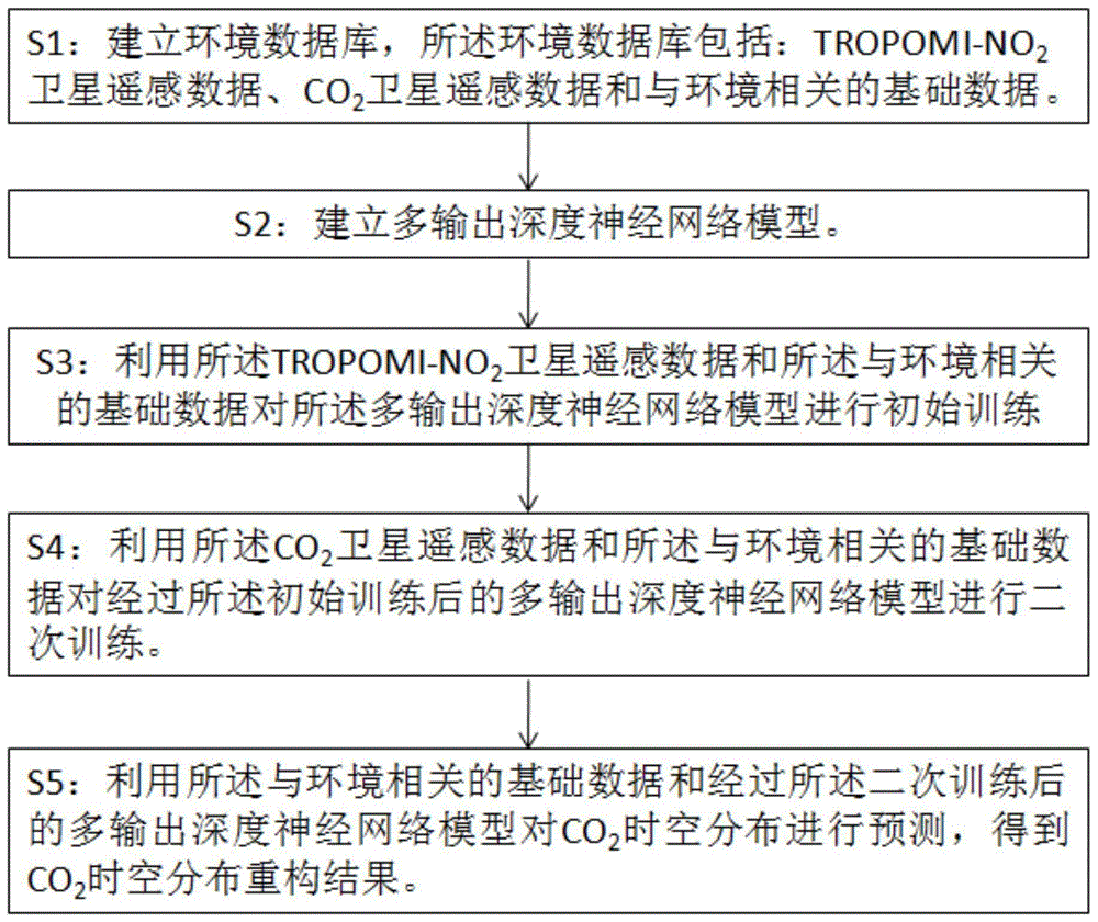
S1:建立环境数据库,所述环境数据库包括:TROPOMI-NO2卫星遥感数据、CO2卫星遥感数据和与环境相关的基础数据;S1: Establish an environmental database, which includes: TROPOMI-NO 2 satellite remote sensing data, CO 2 satellite remote sensing data and basic data related to the environment;
S2:建立多输出深度神经网络模型;S2: Establish a multi-output deep neural network model;
S3:利用所述TROPOMI-NO2卫星遥感数据和所述与环境相关的基础数据对所述多输出深度神经网络模型进行初始训练;S3: Using the TROPOMI-NO 2 satellite remote sensing data and the environment-related basic data to perform initial training on the multi-output deep neural network model;
S4:利用所述CO2卫星遥感数据和所述与环境相关的基础数据对经过所述初始训练后的多输出深度神经网络模型进行二次训练;S4: Using the CO 2 satellite remote sensing data and the environment-related basic data to perform secondary training on the multi-output deep neural network model after the initial training;
S5:利用所述与环境相关的基础数据和经过所述二次训练后的多输出深度神经网络模型对CO2时空分布进行预测,得到CO2时空分布重构结果。S5: Using the basic data related to the environment and the multi-output deep neural network model after the secondary training to predict the temporal and spatial distribution of CO 2 , and obtain a reconstruction result of the temporal and spatial distribution of CO 2 .
作为对本发明的进一步描述,As a further description of the present invention,
所述与环境相关的基础数据包括:CO2排放数据、人口密度数据、海拔高程数据、土地利用数据、归一化植被指数和气象数据;所述气象数据包括:地表温度、地表气压、风速、风向、相对湿度和行星边界层高度。The basic data related to the environment include: CO2 emission data, population density data, altitude data, land use data, normalized difference vegetation index and meteorological data; the meteorological data include: surface temperature, surface air pressure, wind speed, Wind direction, relative humidity, and planetary boundary layer altitude.
作为对本发明的进一步描述,所述S2之前包括:As a further description of the present invention, before said S2 includes:
S11:对所述环境数据库中的所有数据进行1km网格化处理和标准化处理;S11: Perform 1km grid processing and standardization processing on all the data in the environmental database;
S12:将经过所述S11处理后的含有TROPOMI-NO2卫星遥感数据的网格分为初始训练集和初始测试集,将经过所述S11处理后的含有CO2卫星遥感数据的网格分为二次训练集和二次测试集。S12: dividing the grid containing the TROPOMI-NO 2 satellite remote sensing data processed by the S11 into an initial training set and an initial test set, and dividing the grid containing the CO 2 satellite remote sensing data processed by the S11 into Secondary training set and secondary test set.
作为对本发明的进一步描述,所述S2包括以下步骤:As a further description of the present invention, said S2 includes the following steps:
建立第一深度神经网络模型和第二深度神经网络模型,所述第一深度神经网络模型和所述第二深度神经模型具有相同的模型结构,包括:Dense层、Batch Normalization层、激活函数和Dropout层;Establish the first deep neural network model and the second deep neural network model, the first deep neural network model and the second deep neural model have the same model structure, including: Dense layer, Batch Normalization layer, activation function and Dropout layer;
建立所述第一深度神经网络模型和所述第二深度神经网络模型的各层之间对应的数据传输链,所述数据传输链的方向为从所述第一深度神经网络模型到所述第二深度神经网络模型;Establishing a corresponding data transmission chain between the layers of the first deep neural network model and the second deep neural network model, the direction of the data transmission chain is from the first deep neural network model to the second deep neural network model Two deep neural network models;
将所述第一深度神经网络模型的输入端和所述第二深度神经网络模型的输入端与自编码器的输出端连接。Connecting the input end of the first deep neural network model and the input end of the second deep neural network model to the output end of the autoencoder.
作为对本发明的进一步描述,所述S3包括以下步骤:As a further description of the present invention, said S3 includes the following steps:
S31:将所述与环境相关的基础数据作为自变量,将所述初始训练集作为因变量输入所述多输出深度神经网络模型;S31: Using the basic data related to the environment as an independent variable, and inputting the initial training set as a dependent variable into the multi-output deep neural network model;
S32:利用所述第一深度神经网络模型对所述与环境相关的基础数据和所述初始训练集进行深度学习,拟合出所述与环境相关的基础数据与所述TROPOMI-NO2卫星遥感数据之间的初始的非线性关系,并将所述第一深度神经网络的每一层的拟合结果发送给所述第二深度神经网络的对应层;S32: Use the first deep neural network model to perform deep learning on the environment-related basic data and the initial training set, and fit the environment-related basic data and the TROPOMI-NO 2 satellite remote sensing an initial non-linear relationship between the data, and sending the fitting result of each layer of the first deep neural network to the corresponding layer of the second deep neural network;
S33:利用所述第二深度神经网络模型对所述与环境相关的基础数据、所述初始训练集和来自所述第一深度神经网络模型的数据进行深度学习,拟合出所述与环境相关的基础数据与所述TROPOMI-NO2卫星遥感数据之间的最终的非线性关系。S33: Use the second deep neural network model to perform deep learning on the environment-related basic data, the initial training set, and data from the first deep neural network model, and fit the environment-related The final nonlinear relationship between the basic data and the TROPOMI-NO 2 satellite remote sensing data.
作为对本发明的进一步描述,As a further description of the present invention,
所述S32之前包括以下步骤:Said S32 comprises the following steps before:
利用所述自编码器对所述与环境相关的基础数据和所述初始训练集进行降维处理;performing dimensionality reduction processing on the basic data related to the environment and the initial training set by using the autoencoder;
对所述初始训练集进行十字交叉验证;Carry out cross-validation on the initial training set;
所述S33之后包括以下步骤:After said S33, the following steps are included:
利用所述初始测试集对经过所述初始训练后的多输出深度神经网络模型进行测试。Using the initial test set to test the multi-output deep neural network model after the initial training.
作为对本发明的进一步描述,所述S4包括:As a further description of the present invention, said S4 includes:
S41:将所述与环境相关的基础数据作为自变量,将所述二次训练集作为因变量输入所述多输出深度神经网络模型;S41: Using the basic data related to the environment as an independent variable, and inputting the secondary training set as a dependent variable into the multi-output deep neural network model;
S42:仅利用经过所述S33训练后的第二深度神经网模型对所述与环境相关的基础数据和所述二次训练集进行深度学习,拟合出所述与环境相关的基础数据与所述CO2卫星遥感数据之间的非线性关系。S42: Only use the second deep neural network model trained in S33 to perform deep learning on the basic data related to the environment and the secondary training set, and fit the basic data related to the environment and the Describe the nonlinear relationship between CO2 satellite remote sensing data.
作为对本发明的进一步描述,As a further description of the present invention,
所述S42之前,包括以下步骤:利用所述自编码器对所述与环境相关的基础数据和所述二次训练集进行降维处理;Before the S42, the following steps are included: using the autoencoder to perform dimensionality reduction processing on the basic data related to the environment and the secondary training set;
所述S42之后,包括以下步骤:利用所述二次测试集对经过所述二次训练后的多输出深度神经网络模型进行测试。After the S42, the following steps are included: using the secondary test set to test the multi-output deep neural network model after the secondary training.
另一方面,本发明提供一种CO2时空分布重构系统,包括:On the other hand, the present invention provides a system for reconfiguring the spatial - temporal distribution of CO, comprising:
数据库创建模块,用于创建包含TROPOMI-NO2卫星遥感数据、CO2卫星遥感数据和与环境相关的基础数据的环境数据库;Database creation module for creating an environmental database containing TROPOMI-NO 2 satellite remote sensing data, CO 2 satellite remote sensing data and basic data related to the environment;
模型创建模块,用于建立多输出深度神经网络模型;A model creation module for setting up a multi-output deep neural network model;
初始训练模块,用于利用所述TROPOMI-NO2卫星遥感数据和所述与环境相关的基础数据对所述多输出深度神经网络模型进行初始训练;Initial training module, for utilizing said TROPOMI-NO 2 satellite remote sensing data and said environment-related basic data to carry out initial training to said multi-output deep neural network model;
二次训练模块,用于利用所述CO2卫星遥感数据和所述与环境相关的基础数据对经过所述初始训练后的多输出深度神经网络模型进行二次训练;The secondary training module is used to utilize the CO 2 satellite remote sensing data and the basic data related to the environment to carry out secondary training to the multi-output deep neural network model after the initial training;
模型预测模块,用于利用所述与环境相关的基础数据和经过所述二次训练后的多输出深度神经网络模型对CO2时空分布进行预测,得到CO2时空分布重构结果。The model prediction module is used to predict the temporal and spatial distribution of CO 2 by using the basic data related to the environment and the multi-output deep neural network model after the secondary training, and obtain the reconstruction result of the temporal and spatial distribution of CO 2 .
作为对本发明的进一步描述,所述系统还包括:As a further description of the present invention, the system also includes:
数据处理模块,用于对所述环境数据库中的所有数据进行1km网格化处理和标准化处理,并将处理后的含有CO2卫星遥感数据的网格分为二次训练集和二次测试集。The data processing module is used to perform 1km grid processing and standardization processing on all data in the environmental database, and divide the processed grid containing CO2 satellite remote sensing data into a secondary training set and a secondary testing set .
所述模型创建模块包括:The model creation module includes:
第一模型创建单元,用于创建包含Dense层、Batch Normalization层、激活函数和Dropout 层的第一深度神经网络模型,并将所述第一深度神经网络模型的输入端与自编码器的输出端连接;The first model creation unit is used to create a first deep neural network model comprising a Dense layer, a Batch Normalization layer, an activation function and a Dropout layer, and connect the input of the first deep neural network model to the output of an autoencoder connect;
第二模型创建单元,用于创建具有与所述第一深度神经网络模型相同的模型结构的第二深度神经网络模型,并将所述第二深度神经网络模型的输入端与所述自编码器的输出端连接;The second model creation unit is used to create a second deep neural network model having the same model structure as the first deep neural network model, and connect the input terminal of the second deep neural network model to the autoencoder The output terminal connection;
数据传输连创建单元,用于建立所述第一深度神经网络模型和所述第二深度神经网络模型的各层之间对应的数据传输链,所述数据传输链的方向为从所述第一深度神经网络模型到所述第二深度神经网络模型。A data transmission chain creation unit, configured to establish a corresponding data transmission chain between the layers of the first deep neural network model and the second deep neural network model, the direction of the data transmission chain is from the first A deep neural network model to the second deep neural network model.
本发明与现有技术相比,具有如下的优点和有益效果:Compared with the prior art, the present invention has the following advantages and beneficial effects:
1、本发明一方面利用TROPOMI-NO2卫星遥感数据数量多且同样可作为化石燃料燃烧的相关信息的优势,将其引入CO2时空分布重构当中,侧面反映人类活动,可解决现有技术在对CO2时空分布进行重构时缺少相关数据信息的支撑且CO2卫星获取的卫星遥感数据样本量少,导致重构结果出现较大偏差的问题;另一方面,通过建立多输出深度神经网络模型,并对模型依次记性初始训练和二次训练,利用TROPOMI-NO2卫星数据反映化石燃料燃烧的信息以及NO2与CO2排放同源的特性,将TROPOMI-NO2所代表的化石燃料燃烧的信息赋予到模型中,实现对CO2高时空分辨率时空分布的重构。1. On the one hand, the present invention takes advantage of the large amount of TROPOMI-NO 2 satellite remote sensing data and can also be used as relevant information on fossil fuel combustion, and introduces it into the reconstruction of CO 2 temporal and spatial distribution, reflecting human activities from the side, which can solve the problem of existing technologies When reconstructing the temporal and spatial distribution of CO 2 , there is a lack of support for relevant data information and the sample size of satellite remote sensing data acquired by CO 2 satellites is small, resulting in large deviations in the reconstruction results; on the other hand, by establishing a multi-output deep neural network Network model, and remember the initial training and secondary training for the model in sequence, using the TROPOMI-NO 2 satellite data to reflect the information of fossil fuel combustion and the characteristics of the same source of NO 2 and CO 2 emissions, the fossil fuel represented by TROPOMI-NO 2 Combustion information is given to the model to realize the reconstruction of the spatial and temporal distribution of CO2 with high temporal and spatial resolution.
2、本发明通过自编码器部分对初始自变量维数进行了降维处理,提升了数据的可学习性;2. The present invention performs dimensionality reduction processing on the initial independent variable dimension through the autoencoder part, which improves the learnability of the data;
3、本发明利用迁移学习方法将TROPOMI-NO2和CO2在时空分布上的相关信息有效结合,将TROPOMI-NO2数据作为辅助数据,解决了CO2数据稀疏的问题,并提高CO2浓度预测结果的准确性。3. The present invention utilizes the transfer learning method to effectively combine the relevant information of TROPOMI-NO2 and CO2 on the temporal and spatial distribution, and uses the TROPOMI- NO2 data as auxiliary data, which solves the problem of CO2 data sparseness and improves the CO2 concentration prediction results accuracy.
附图说明Description of drawings
为了更清楚地说明本发明示例性实施方式的技术方案,下面将对实施例中所需要使用的附图作简单地介绍,应当理解,以下附图仅示出了本发明的某些实施例,因此不应被看作是对范围的限定,对于本领域普通技术人员来讲,在不付出创造性劳动的前提下,还可以根据这些附图获得其他相关的附图。In order to more clearly illustrate the technical solutions of the exemplary embodiments of the present invention, the accompanying drawings used in the embodiments will be briefly introduced below. It should be understood that the following drawings only show some embodiments of the present invention. Therefore, it should not be regarded as a limitation on the scope. For those skilled in the art, other related drawings can also be obtained according to these drawings without creative work.
图1为本发明实施例提供的一种CO2时空分布重构方法流程示意图;Fig. 1 is a kind of CO2 spatio-temporal distribution reconfiguration method schematic flowchart provided by the embodiment of the present invention;
图2为本发明实施例提供的多重输出深度神经网络模型结构示意图;Fig. 2 is a schematic structural diagram of a multi-output deep neural network model provided by an embodiment of the present invention;
图3为本发明实施例提供的一种CO2时空分布重构系统结构示意图。Fig. 3 is a schematic structural diagram of a CO 2 spatiotemporal distribution reconstruction system provided by an embodiment of the present invention.
具体实施方式Detailed ways
为使本发明的目的、技术方案和优点更加清楚明白,下面结合实施例和附图,对本发明作进一步的详细说明,本发明的示意性实施方式及其说明仅用于解释本发明,并不作为对本发明的限定。In order to make the purpose, technical solutions and advantages of the present invention clearer, the present invention will be further described in detail below in conjunction with the examples and accompanying drawings. As a limitation of the present invention.
在以下描述中,为了提供对本发明的透彻理解阐述了大量特定细节。然而,对于本领域普通技术人员显而易见的是:不必采用这些特定细节来实行本发明。在其他实施例中,为了避免混淆本发明,未具体描述公知的结构、电路、材料或方法。In the following description, numerous specific details are set forth in order to provide a thorough understanding of the present invention. It will be apparent, however, to one of ordinary skill in the art that these specific details need not be employed to practice the present invention. In other instances, well-known structures, circuits, materials, or methods have not been described in detail in order to avoid obscuring the present invention.
在整个说明书中,对“一个实施例”、“实施例”、“一个示例”或“示例”的提及意味着:结合该实施例或示例描述的特定特征、结构或特性被包含在本发明至少一个实施例中。因此,在整个说明书的各个地方出现的短语“一个实施例”、“实施例”、“一个示例”或“示例”不一定都指同一实施例或示例。此外,可以以任何适当的组合和、或子组合将特定的特征、结构或特性组合在一个或多个实施例或示例中。此外,本领域普通技术人员应当理解,在此提供的示图都是为了说明的目的,并且示图不一定是按比例绘制的。这里使用的术语“和/或”包括一个或多个相关列出的项目的任何和所有组合。Throughout this specification, reference to "one embodiment," "an embodiment," "an example," or "example" means that a particular feature, structure, or characteristic described in connection with the embodiment or example is included in the present invention. In at least one embodiment. Thus, appearances of the phrases "one embodiment," "an embodiment," "an example," or "example" in various places throughout this specification are not necessarily all referring to the same embodiment or example. Furthermore, particular features, structures or characteristics may be combined in any suitable combination and/or subcombination in one or more embodiments or examples. Furthermore, those of ordinary skill in the art will appreciate that the drawings provided herein are for illustrative purposes and are not necessarily drawn to scale. As used herein, the term "and/or" includes any and all combinations of one or more of the associated listed items.
在本发明的描述中,术语“前”、“后”、“左”、“右”、“上”、“下”、“竖直”、“水平”、“高”、“低”“内”、“外”等指示的方位或位置关系为基于附图所示的方位或位置关系,仅是为了便于描述本发明和简化描述,而不是指示或暗示所指的装置或元件必须具有特定的方位、以特定的方位构造和操作,因此不能理解为对本发明保护范围的限制。In the description of the present invention, the terms "front", "rear", "left", "right", "upper", "lower", "vertical", "horizontal", "higher", "lower", "inner ", "outside" and other indicated orientations or positional relationships are based on the orientations or positional relationships shown in the drawings, which are only for the convenience of describing the present invention and simplifying the description, rather than indicating or implying that the referred device or element must have a specific Orientation, construction and operation in a particular orientation, therefore, should not be construed as limiting the scope of the invention.
实施例1Example 1
由于现有技术在对CO2时空分布进行重构时缺少相关数据信息的支撑,且CO2卫星在获取数据时易受到外界条件干扰,导致CO2重构过程中出现较大偏差的问题,本实施例提供了一种CO2时空分布重构方法,其方法流程如图1所示,利用TROPOMI-NO2的卫星数据作为化石燃料燃烧的相关信息,基于共享参数的迁移学习方法,实现对CO2浓度全面域时空分布的重构。主要建模过程为以TROPOMI-NO2作为因变量对深度学习模型进行预训练,使模型拟合自变量与TROPOMI-NO2之间的非线性关系,再以CO2作为因变量,对预训练后的模型进行最终训练。通过以上方法,模型在重构出准确度更高的TROPOMI-NO2高时空分辨率数据集的同时,将TROPOMI-NO2所代表的化石燃料燃烧的信息赋予到模型中,实现对CO2高时空分辨率时空分布的重构。实施步骤如下:Because the existing technology lacks the support of relevant data information when reconstructing the temporal and spatial distribution of CO 2 , and CO 2 satellites are easily disturbed by external conditions when acquiring data, resulting in large deviations in the process of CO 2 reconstruction, this paper The embodiment provides a method for reconstructing the temporal and spatial distribution of CO 2 , the process flow of which is shown in Figure 1, using the satellite data of TROPOMI-NO 2 as the relevant information of fossil fuel combustion, and based on the transfer learning method of shared parameters, the CO 2 Reconstruction of spatial and temporal distribution of concentration in the global domain. The main modeling process is to pre-train the deep learning model with TROPOMI-NO 2 as the dependent variable, so that the model can fit the nonlinear relationship between the independent variable and TROPOMI-NO 2 , and then use CO 2 as the dependent variable to pre-train The final model is then trained. Through the above method, while reconstructing the TROPOMI-NO 2 high-temporal-spatial resolution data set with higher accuracy, the model also endows the information of fossil fuel combustion represented by TROPOMI-NO 2 into the model, realizing the high-level analysis of CO 2 Reconstruction of spatiotemporal distributions at spatiotemporal resolution. The implementation steps are as follows:
S1:建立环境数据库,所述环境数据库包括:TROPOMI-NO2卫星遥感数据、CO2卫星遥感数据和与环境相关的基础数据。其中,环境相关的基础数据包括:CO2排放数据、人口密度数据、海拔高程数据、土地利用数据、归一化植被指数和气象数据;所述气象数据包括:地表温度、地表气压、风速、风向、相对湿度和行星边界层高度。S1: Establish an environmental database, which includes: TROPOMI-NO 2 satellite remote sensing data, CO 2 satellite remote sensing data and basic data related to the environment. Among them, the environment-related basic data include: CO2 emission data, population density data, altitude data, land use data, normalized difference vegetation index and meteorological data; the meteorological data include: surface temperature, surface pressure, wind speed, wind direction , relative humidity and altitude of the planetary boundary layer.
利用TROPOMI-NO2卫星遥感数据数量多且同样可作为化石燃料燃烧的相关信息的优势,将其引入CO2时空分布重构当中,侧面反映人类活动,可解决现有技术在对CO2时空分布进行重构时缺少相关数据信息的支撑且CO2卫星获取的卫星遥感数据样本量少,导致重构结果出现较大偏差的问题,准确地全覆盖CO2浓度预测结果可为碳排放统计核算提供依据,并为降碳政策的制定提供数据支撑。Taking advantage of the large amount of TROPOMI-NO 2 satellite remote sensing data which can also be used as relevant information on fossil fuel combustion, it is introduced into the reconstruction of the temporal and spatial distribution of CO 2 to reflect human activities from the side, which can solve the problems of existing technologies in the analysis of the temporal and spatial distribution of CO 2 The lack of support for relevant data information and the small sample size of satellite remote sensing data acquired by CO 2 satellites during reconstruction lead to large deviations in reconstruction results. Accurate full coverage of CO 2 concentration prediction results can provide a basis for carbon emission statistics and accounting. and provide data support for the formulation of carbon reduction policies.
S2:对所述环境数据库中的所有数据进行1km网格化处理和标准化处理。具体包括以下步骤:S2: Perform 1 km grid processing and standardization processing on all the data in the environmental database. Specifically include the following steps:
S21:对人口密度数据、海拔高程数据、土地利用数据、归一化植被指数变量采取面积加权平均法,使其空间分辨率转化为1km网格;S21: Take the area weighted average method for the population density data, altitude data, land use data, and normalized difference vegetation index variables to convert the spatial resolution into a 1km grid;
S22:对CO2排放清单、气象数据则采用高程协克里金插值重采样至1km网格。S22: CO2 emission inventory and meteorological data are resampled to a 1km grid using elevation cokriging interpolation.
S23:将以上数据处理至相同空间尺度后,分别对其进行标准化,使各个自变量处于相同的数据尺度,有利于深度学习模型的训练。S23: After processing the above data to the same spatial scale, standardize them respectively, so that each independent variable is at the same data scale, which is beneficial to the training of the deep learning model.
S24:对TROPOMI-NO2卫星遥感数据和CO2卫星遥感数据进行1km网格化处理,将讲过步骤(1)至步骤(3)处理后的含有TROPOMI-NO2卫星遥感数据的网格分为初始训练集和初始测试集;将讲过步骤(1)至步骤(3)处理后的含有CO2卫星遥感数据的网格分为二次训练集和二次测试集。S24: Carry out 1 km grid processing on the TROPOMI-NO 2 satellite remote sensing data and CO 2 satellite remote sensing data, and divide the grid containing the TROPOMI-NO 2 satellite remote sensing data after the processing from step (1) to step (3) It is an initial training set and an initial test set; the grid containing CO 2 satellite remote sensing data processed from step (1) to step (3) is divided into a secondary training set and a secondary test set.
S3:建立多输出深度神经网络模型。包括以下步骤:S3: Establish a multi-output deep neural network model. Include the following steps:
S31:建立第一深度神经网络模型和第二深度神经网络模型,所述第一深度神经网络模型和所述第二深度神经模型具有相同的模型结构,包括:Dense层、BatchNormalization层、激活函数和Dropout层;S31: Establish a first deep neural network model and a second deep neural network model, the first deep neural network model and the second deep neural model have the same model structure, including: Dense layer, BatchNormalization layer, activation function and Dropout layer;
S32:建立所述第一深度神经网络模型和所述第二深度神经网络模型的各层之间对应的数据传输链,所述数据传输链的方向为从所述第一深度神经网络模型到所述第二深度神经网络模型;S32: Establish a corresponding data transmission chain between the layers of the first deep neural network model and the second deep neural network model, the direction of the data transmission chain is from the first deep neural network model to the Describe the second deep neural network model;
S33:将所述第一深度神经网络模型的输入端和所述第二深度神经网络模型的输入端与自编码器的输出端连接。S33: Connect the input end of the first deep neural network model and the input end of the second deep neural network model to the output end of the autoencoder.
其中所使用的深度学习模型为基于自编码器的多输出深度神经网络,如图2所示,模型共有三个模块组成,包括自编码器和两个子深度学习模块。The deep learning model used is a multi-output deep neural network based on an autoencoder. As shown in Figure 2, the model consists of three modules, including an autoencoder and two sub-deep learning modules.
该模型利用自编码器来对自变量数量进行降维,本实施例利用降维后的变量分别构建的第一深度神经网络模型和第二深度神经网络模型。所述第一深度神经网络模型和所述第二深度神经网络模型中的全连接层包含神经网络最基本的Dense层,并使用了BatchNormalization、激活函数以及Dropout。且两个深度神经网络模型之间存在单向连接,即第一深度神经网络模型的各层输出均会与第二深度神经网络模型的各层输出相加,以作为第二深度神经网络模型下一层的输入数据。The model uses an autoencoder to reduce the dimensionality of the number of independent variables. In this embodiment, the first deep neural network model and the second deep neural network model are respectively constructed using the reduced dimensionality variables. The fully connected layers in the first deep neural network model and the second deep neural network model include the most basic Dense layer of the neural network, and use BatchNormalization, activation function and Dropout. And there is a one-way connection between the two deep neural network models, that is, the output of each layer of the first deep neural network model will be added to the output of each layer of the second deep neural network model to serve as the output of the second deep neural network model. A layer of input data.
S34:本发明使用联合损失函数来对模型进行优化,各输出所对应的损失函数均基于均方根误差(Mean Squared Error,MSE),具体的函数表达式如下所示:S34: The present invention uses a joint loss function to optimize the model. The loss function corresponding to each output is based on the root mean square error (Mean Squared Error, MSE). The specific function expression is as follows:
输出一:
Lossmin=min(Loss2,Loss3)Loss min = min(Loss 2 , Loss 3 )
输出二:
输出三:
整体输出:Lossall=λminLoss1+(1-λ)Loss2+λLoss3 Overall output: Loss all = λ min Loss 1 + (1-λ) Loss 2 + λLoss 3
λmin=min(λ,1-λ)λ min = min(λ, 1-λ)
其中:
S4:利用所述TROPOMI-NO2卫星遥感数据和所述与环境相关的基础数据对所述多输出深度神经网络模型进行初始训练。包括以下步骤:S4: Initially train the multi-output deep neural network model by using the TROPOMI-NO 2 satellite remote sensing data and the environment-related basic data. Include the following steps:
S41:将所述与环境相关的基础数据作为自变量,将所述初始训练集作为因变量输入所述多输出深度神经网络模型;S41: Using the basic data related to the environment as an independent variable, and inputting the initial training set as a dependent variable into the multi-output deep neural network model;
S42:利用所述自编码器对所述与环境相关的基础数据和所述初始训练集进行降维处理;S42: Using the autoencoder to perform dimensionality reduction processing on the environment-related basic data and the initial training set;
S43:利用所述第一深度神经网络模型对所述与环境相关的基础数据和所述初始训练集进行深度学习,拟合出所述与环境相关的基础数据与所述TROPOMI-NO2卫星遥感数据之间的初始的非线性关系,并将所述第一深度神经网络的每一层的拟合结果发送给所述第二深度神经网络的对应层;S43: Use the first deep neural network model to perform deep learning on the environment-related basic data and the initial training set, and fit the environment-related basic data and the TROPOMI-NO 2 satellite remote sensing an initial non-linear relationship between the data, and sending the fitting result of each layer of the first deep neural network to the corresponding layer of the second deep neural network;
S44:利用所述第二深度神经网络模型对所述与环境相关的基础数据、所述初始训练集和来自所述第一深度神经网络模型的数据进行深度学习,拟合出所述与环境相关的基础数据与所述TROPOMI-NO2卫星遥感数据之间的最终的非线性关系;S44: Use the second deep neural network model to perform deep learning on the environment-related basic data, the initial training set, and data from the first deep neural network model, and fit the environment-related The final non-linear relationship between the basic data and the TROPOMI-NO 2 satellite remote sensing data;
S45:利用所述初始测试集对经过所述初始训练后的多输出深度神经网络模型进行测试。S45: Use the initial test set to test the multi-output deep neural network model after the initial training.
为模型具有较好的泛化能力,本实施例中将含有TROPOMI-NO2卫星遥感数据的网格分为初始训练集和初始测试集,并针对初始训练集采用十字交叉验证,用于确定模型的最佳参数;初始测试集仅用于评价模型的泛化能力,不参与到模型的预训练过程中。For the model to have a better generalization ability, in this embodiment, the grid containing TROPOMI-NO 2 satellite remote sensing data is divided into an initial training set and an initial test set, and cross-validation is used for the initial training set to determine the model The optimal parameters of ; the initial test set is only used to evaluate the generalization ability of the model, and does not participate in the pre-training process of the model.
在进行初始训练时,以CO2排放清单、人口密度数据、海拔高程数据、土地利用数据、归一化植被指数、气象数据作为模型的输入数据。输出一为输入数据本身,第一深度神经网络模型和第二深度神经网络模型的输出均为TROPOMI-NO2卫星遥感数据,从而利用TROPOMI-NO2数据数量较多的优势,完成对模型中参数的初始优化。During initial training, CO2 emission inventory, population density data, altitude data, land use data, normalized difference vegetation index, and meteorological data are used as input data for the model. Output 1 is the input data itself, and the output of the first deep neural network model and the second deep neural network model are both TROPOMI-NO 2 satellite remote sensing data, thus taking advantage of the large amount of TROPOMI-NO 2 data to complete the parameters in the model initial optimization.
通过对模型的初始训练,分别有第一深度神经网络模型和第二深度神经网络模型构建了两个不同的与环境有关的集成数据(以下简称自变量)与TROPOMI-NO2卫星遥感数据之间的非线性关系。模型中的解码器部分和第一深度神经网络模型部分反映了自变量与TROPOMI-NO2卫星遥感数据间的非线性关系,第二深度神经网络模型则是结合了第一深度神经网络模型中TROPOMI-NO2卫星遥感数据的相关信息来构建自变量与TROPOMI-NO2卫星遥感数据的非线性关系。Through the initial training of the model, the first deep neural network model and the second deep neural network model respectively construct the relationship between two different integrated data related to the environment (hereinafter referred to as independent variables) and TROPOMI-NO 2 satellite remote sensing data. non-linear relationship. The decoder part and the first deep neural network model in the model reflect the nonlinear relationship between independent variables and TROPOMI-NO 2 satellite remote sensing data, and the second deep neural network model combines the TROPOMI -NO 2 satellite remote sensing data to construct the non-linear relationship between independent variables and TROPOMI-NO 2 satellite remote sensing data.
此外,通过自编码器部分对初始自变量维数进行了降维,提升了数据的可学习性。In addition, the dimensionality of the initial independent variable is reduced through the autoencoder part, which improves the learnability of the data.
自变量与TROPOMI-NO2卫星遥感数据间的关系式为:YTROPOMI-NO2=f(x1,x2…,xn)。The relationship between independent variables and TROPOMI-NO 2 satellite remote sensing data is: Y TROPOMI-NO2 = f(x 1 , x 2 ..., x n ).
S5:利用所述CO2卫星遥感数据和所述与环境相关的基础数据对经过所述初始训练后的多输出深度神经网络模型进行二次训练。包括以下步骤:S5: Using the CO 2 satellite remote sensing data and the environment-related basic data to perform secondary training on the multi-output deep neural network model after the initial training. Include the following steps:
S51:将所述与环境相关的基础数据作为自变量,将所述二次训练集作为因变量输入所述多输出深度神经网络模型;S51: Using the basic data related to the environment as an independent variable, and inputting the secondary training set as a dependent variable into the multi-output deep neural network model;
S52:利用所述自编码器对所述与环境相关的基础数据和所述二次训练集进行降维处理;S52: Using the autoencoder to perform dimensionality reduction processing on the environment-related basic data and the secondary training set;
S53:仅利用经过所述S33训练后的第二深度神经网模型对所述与环境相关的基础数据和所述二次训练集进行深度学习,拟合出所述与环境相关的基础数据与所述CO2卫星遥感数据之间的非线性关系;S53: Only use the second deep neural network model trained in S33 to perform deep learning on the basic data related to the environment and the secondary training set, and fit the basic data related to the environment and the Describe the nonlinear relationship between CO2 satellite remote sensing data;
S54:利用所述二次测试集对经过所述二次训练后的多输出深度神经网络模型进行测试。S54: Using the secondary test set to test the secondary trained multi-output deep neural network model.
本实施例将含有CO2卫星遥感数据的网格分为二次训练集和二次测试集,二次训练集用于确定模型的最佳参数,二次测试集仅用于评价模型的泛化能力。In this embodiment, the grid containing CO satellite remote sensing data is divided into a secondary training set and a secondary testing set. The secondary training set is used to determine the optimal parameters of the model, and the secondary testing set is only used to evaluate the generalization of the model. ability.
在对模型进行二次训练时,将模型中的自编码器和第一深度神经网络模型的参数进行冻结,使这自编码器和第一深度神经网络模型的参数在二次训练过程中不发生改变。模型的输入数据的变量类型与初次训练时相同,而仅有第二深度神经网络模型参与到训练当中,用以构建自变量与CO2之间的非线性关系。When the model is trained for the second time, the parameters of the autoencoder and the first deep neural network model in the model are frozen so that the parameters of the autoencoder and the first deep neural network model do not occur during the second training process Change. The variable type of the input data of the model is the same as that of the initial training, and only the second deep neural network model is involved in the training to construct the nonlinear relationship between the independent variable and CO 2 .
由于在初始训练过程当中,第一深度神经网络模型能够提供TROPOMI-NO2卫星遥感数据相关信息,故第二深度神经网络模型能够结合TROPOMI-NO2卫星遥感数据实现对CO2的有效预测。下式为第二深度是神经网络模型所构建的自变量与CO2卫星遥感数据之间的关系: YCO2=f(x1,x2…,xn,YTROPOMI-NO2)。Since the first deep neural network model can provide information related to TROPOMI-NO 2 satellite remote sensing data during the initial training process, the second deep neural network model can combine TROPOMI-NO 2 satellite remote sensing data to achieve an effective prediction of CO 2 . The following formula is the relationship between the independent variable constructed by the second depth neural network model and the CO 2 satellite remote sensing data: Y CO2 =f(x 1 , x 2 . . . , x n , Y TROPOMI-NO2 ).
S6:利用所述与环境相关的基础数据和经过所述二次训练后的多输出深度神经网络模型对CO2时空分布进行预测,得到CO2时空分布重构结果。S6: Using the basic data related to the environment and the multi-output deep neural network model after the second training to predict the temporal and spatial distribution of CO 2 , and obtain a reconstruction result of the temporal and spatial distribution of CO 2 .
在完成模型的初始训练和二次训练以后,将区域范围内的自变量输入至训练好的多输出深度神经网络模型当中,通过第一深度神经网络模型输出空间分辨率为1km,时间分辨率为天的TROPOMI-NO2时空分布的重构结果,通过第二深度神经网络模型输出空间分辨率为 1km,时间分辨率为天的CO2时空分布的重构结果,实现区域范围内TROPOMI-NO2和CO2高分辨率时空分布重构。After completing the initial training and secondary training of the model, the independent variables within the region are input into the trained multi-output deep neural network model, and the spatial resolution of the first deep neural network model is 1km, and the temporal resolution is The reconstruction results of the temporal and spatial distribution of TROPOMI-NO 2 in the day, through the second deep neural network model output the reconstruction results of the temporal and spatial distribution of CO 2 with a spatial resolution of 1km and a temporal resolution of the day, realizing the regional TROPOMI-NO 2 and CO2 high-resolution spatiotemporal distribution reconstruction.
综上,本实施例提供的一种CO2时空分布重构方法,在缺乏与人类活动直接相关数据的情况下,利用NO2卫星遥感数据TROPOMI-NO2侧面反映人类活动,重构出CO2高分辨率时空分布,准确地全覆盖CO2浓度预测结果可为碳排放统计核算提供依据,并为降碳政策的制定提供数据支撑。并且,该方法中通过自编码器部分对初始自变量维数进行了降维,提升了数据的可学习性。利用迁移学习方法将TROPOMI-NO2和CO2在时空分布上的相关信息有效结合,将TROPOMI-NO2数据作为辅助数据,提高CO2浓度预测结果的准确性。To sum up, this example provides a method for reconstructing the temporal and spatial distribution of CO 2 . In the absence of data directly related to human activities, the NO 2 satellite remote sensing data TROPOMI-NO 2 is used to reflect human activities and reconstruct CO 2 High-resolution spatio-temporal distribution and accurate full-coverage CO 2 concentration prediction results can provide a basis for statistical accounting of carbon emissions and provide data support for the formulation of carbon reduction policies. Moreover, in this method, the dimensionality of the initial independent variable is reduced through the autoencoder part, which improves the learnability of the data. The transfer learning method is used to effectively combine the relevant information of TROPOMI-NO 2 and CO 2 on the temporal and spatial distribution, and use the TROPOMI-NO 2 data as auxiliary data to improve the accuracy of CO 2 concentration prediction results.
实施例2Example 2
本实施例提供一种与实施例1所述的CO2时空分布重构方法相应的系统,如图3,包括:This embodiment provides a system corresponding to the method for reconfiguring CO spatio- temporal distribution described in Embodiment 1, as shown in Figure 3, including:
数据库创建模块,用于创建包含TROPOMI-NO2卫星遥感数据、CO2卫星遥感数据和与环境相关的基础数据的环境数据库;Database creation module for creating an environmental database containing TROPOMI-NO 2 satellite remote sensing data, CO 2 satellite remote sensing data and basic data related to the environment;
模型创建模块,用于建立多输出深度神经网络模型;A model creation module for setting up a multi-output deep neural network model;
初始训练模块,用于利用所述TROPOMI-NO2卫星遥感数据和所述与环境相关的基础数据对所述多输出深度神经网络模型进行初始训练;Initial training module, for utilizing said TROPOMI-NO 2 satellite remote sensing data and said environment-related basic data to carry out initial training to said multi-output deep neural network model;
二次训练模块,用于利用所述CO2卫星遥感数据和所述与环境相关的基础数据对经过所述初始训练后的多输出深度神经网络模型进行二次训练;The secondary training module is used to utilize the CO 2 satellite remote sensing data and the basic data related to the environment to carry out secondary training to the multi-output deep neural network model after the initial training;
模型预测模块,用于利用所述与环境相关的基础数据和经过所述二次训练后的多输出深度神经网络模型对CO2时空分布进行预测,得到CO2时空分布重构结果。The model prediction module is used to predict the temporal and spatial distribution of CO 2 by using the basic data related to the environment and the multi-output deep neural network model after the secondary training, and obtain the reconstruction result of the temporal and spatial distribution of CO 2 .
数据处理模块,用于对所述环境数据库中的所有数据进行1km网格化处理和标准化处理,并将处理后的含有CO2卫星遥感数据的网格分为二次训练集和二次测试集。The data processing module is used to perform 1km grid processing and standardization processing on all data in the environmental database, and divide the processed grid containing CO2 satellite remote sensing data into a secondary training set and a secondary testing set .
其中,模型创建模块包括:Among them, the model creation module includes:
第一模型创建单元,用于创建包含Dense层、Batch Normalization层、激活函数和Dropout 层的第一深度神经网络模型,并将所述第一深度神经网络模型的输入端与自编码器的输出端连接;The first model creation unit is used to create a first deep neural network model comprising a Dense layer, a Batch Normalization layer, an activation function and a Dropout layer, and connect the input of the first deep neural network model to the output of an autoencoder connect;
第二模型创建单元,用于创建具有与所述第一深度神经网络模型相同的模型结构的第二深度神经网络模型,并将所述第二深度神经网络模型的输入端与所述自编码器的输出端连接;The second model creation unit is used to create a second deep neural network model having the same model structure as the first deep neural network model, and connect the input terminal of the second deep neural network model to the autoencoder The output terminal connection;
数据传输连创建单元,用于建立所述第一深度神经网络模型和所述第二深度神经网络模型的各层之间对应的数据传输链,所述数据传输链的方向为从所述第一深度神经网络模型到所述第二深度神经网络模型A data transmission chain creation unit, configured to establish a corresponding data transmission chain between the layers of the first deep neural network model and the second deep neural network model, the direction of the data transmission chain is from the first deep neural network model to the second deep neural network model
以上所述的具体实施方式,对本发明的目的、技术方案和有益效果进行了进一步详细说明,所应理解的是,以上所述仅为本发明的具体实施方式而已,并不用于限定本发明的保护范围,凡在本发明的精神和原则之内,所做的任何修改、等同替换、改进等,均应包含在本发明的保护范围之内。The specific embodiments described above have further described the purpose, technical solutions and beneficial effects of the present invention in detail. It should be understood that the above descriptions are only specific embodiments of the present invention and are not intended to limit the scope of the present invention. Protection scope, within the spirit and principles of the present invention, any modification, equivalent replacement, improvement, etc., shall be included in the protection scope of the present invention.
Claims (7)
Priority Applications (1)
| Application Number | Priority Date | Filing Date | Title |
|---|---|---|---|
| CN202210490951.6A CN114861882B (en) | 2022-05-07 | 2022-05-07 | A CO2 spatio-temporal distribution reconstruction method and system |
Applications Claiming Priority (1)
| Application Number | Priority Date | Filing Date | Title |
|---|---|---|---|
| CN202210490951.6A CN114861882B (en) | 2022-05-07 | 2022-05-07 | A CO2 spatio-temporal distribution reconstruction method and system |
Publications (2)
| Publication Number | Publication Date |
|---|---|
| CN114861882A CN114861882A (en) | 2022-08-05 |
| CN114861882B true CN114861882B (en) | 2023-05-09 |
Family
ID=82636115
Family Applications (1)
| Application Number | Title | Priority Date | Filing Date |
|---|---|---|---|
| CN202210490951.6A Active CN114861882B (en) | 2022-05-07 | 2022-05-07 | A CO2 spatio-temporal distribution reconstruction method and system |
Country Status (1)
| Country | Link |
|---|---|
| CN (1) | CN114861882B (en) |
Families Citing this family (2)
| Publication number | Priority date | Publication date | Assignee | Title |
|---|---|---|---|---|
| CN115310550B (en) * | 2022-08-16 | 2023-07-14 | 国网四川省电力公司电力科学研究院 | A method and system for calculating the concentration of atmospheric carbon dioxide dry air column |
| CN118760974B (en) * | 2024-06-12 | 2024-12-10 | 中国科学院空天信息创新研究院 | A method and system for filling atmospheric CO2 data using a feedforward neural network combined with time series changes |
Family Cites Families (5)
| Publication number | Priority date | Publication date | Assignee | Title |
|---|---|---|---|---|
| CN106529081A (en) * | 2016-12-03 | 2017-03-22 | 安徽新华学院 | PM2.5 real-time level prediction method and system based on neural net |
| US20210209424A1 (en) * | 2020-01-06 | 2021-07-08 | Quantela Inc | Computer-based method and system for predicting and generating land use land cover (lulc) classification |
| CN113128780A (en) * | 2021-04-29 | 2021-07-16 | 平安普惠企业管理有限公司 | PM2.5 concentration prediction method and device, computer equipment and storage medium |
| CN113297528B (en) * | 2021-06-10 | 2022-07-01 | 四川大学 | NO based on multi-source big data2High-resolution space-time distribution calculation method |
| CN114266200B (en) * | 2022-02-24 | 2022-07-05 | 山东大学 | Nitrogen dioxide concentration prediction method and system |
-
2022
- 2022-05-07 CN CN202210490951.6A patent/CN114861882B/en active Active
Also Published As
| Publication number | Publication date |
|---|---|
| CN114861882A (en) | 2022-08-05 |
Similar Documents
| Publication | Publication Date | Title |
|---|---|---|
| CN110738252B (en) | Machine learning satellite precipitation data downscaling method and system for spatial autocorrelation | |
| Badi et al. | Optimal site selection for sitting a solar park using a novel GIS-SWA’TEL model: A case study in Libya | |
| CN111859800A (en) | A method for spatiotemporal estimation and prediction of PM2.5 concentration distribution | |
| CN114861882B (en) | A CO2 spatio-temporal distribution reconstruction method and system | |
| Do et al. | Graph-deep-learning-based inference of fine-grained air quality from mobile IoT sensors | |
| CN111210082A (en) | A Precipitation Prediction Method Based on Optimized BP Neural Network Algorithm | |
| CN109242170A (en) | A kind of City Road Management System and method based on data mining technology | |
| CN116029419B (en) | Deep learning-based long-term new energy daily average generation power prediction method and system | |
| CN112784173A (en) | Recommendation system scoring prediction method based on self-attention confrontation neural network | |
| CN117333046A (en) | Multisource meteorological data integration and quality control system | |
| Mayer et al. | Optimal place to apply post-processing in the deterministic photovoltaic power forecasting workflow | |
| Zhang et al. | Mapping the seamless hourly surface visibility in China: a real-time retrieval framework using a machine-learning-based stacked ensemble model | |
| CN117033923A (en) | Method and system for predicting crime quantity based on interpretable machine learning | |
| Jahangir et al. | Physics-guided machine learning predicts the planet-scale performance of solar farms with sparse, heterogeneous, public data | |
| Jin et al. | Evaluation of forecasted wind speed at turbine hub height and wind ramps by five NWP models with observations from 262 wind farms over China | |
| Tam et al. | Evaluation of ANN using air quality tracking in subtropical medium-sized urban city | |
| CN120513450A (en) | Photovoltaic power prediction method and device, electronic equipment and storage medium | |
| Huang et al. | Application of an extension method on optimal site selection for PV power systems: A case study in Taiwan | |
| CN118781806A (en) | Intelligent traffic information sharing method and system | |
| Rui et al. | RETRACTED ARTICLE: Neural network-based urban green vegetation coverage detection and smart home system optimization | |
| Su et al. | An improved geographic pattern based residual neural network model for estimating PM2. 5 concentrations | |
| Melinc et al. | A unified neural background‐error covariance model for midlatitude and tropical atmospheric data assimilation | |
| Wu et al. | A novel hybrid spatiotemporal prediction algorithm of solar radiation based on topology and deep learning models | |
| Kang et al. | Solar irradiance prediction based on self-attention recursive model network | |
| Terrén-Serrano et al. | Probabilistic day-ahead forecasting of system-level renewable energy and electricity demand |
Legal Events
| Date | Code | Title | Description |
|---|---|---|---|
| PB01 | Publication | ||
| PB01 | Publication | ||
| SE01 | Entry into force of request for substantive examination | ||
| SE01 | Entry into force of request for substantive examination | ||
| GR01 | Patent grant | ||
| GR01 | Patent grant |