CN114486764B - Agricultural non-point source pollution monitoring system based on full spectrum water quality analyzer - Google Patents

Agricultural non-point source pollution monitoring system based on full spectrum water quality analyzer Download PDF

Info

Publication number
CN114486764B
CN114486764B CN202210095885.2A CN202210095885A CN114486764B CN 114486764 B CN114486764 B CN 114486764B CN 202210095885 A CN202210095885 A CN 202210095885A CN 114486764 B CN114486764 B CN 114486764B
Authority
CN
China
Prior art keywords
farmland
area
water quality
data
wetland
Prior art date
Legal status (The legal status is an assumption and is not a legal conclusion. Google has not performed a legal analysis and makes no representation as to the accuracy of the status listed.)
Active
Application number
CN202210095885.2A
Other languages
Chinese (zh)
Other versions
CN114486764A (en
Inventor
张友德
钱益武
何建军
戴曹培
田文凤
张甜甜
王清泉
Current Assignee (The listed assignees may be inaccurate. Google has not performed a legal analysis and makes no representation or warranty as to the accuracy of the list.)
Anhui Xinyu Environmental Protection Technology Co ltd
Original Assignee
Anhui Xinyu Environmental Protection Technology Co ltd
Priority date (The priority date is an assumption and is not a legal conclusion. Google has not performed a legal analysis and makes no representation as to the accuracy of the date listed.)
Filing date
Publication date
Application filed by Anhui Xinyu Environmental Protection Technology Co ltd filed Critical Anhui Xinyu Environmental Protection Technology Co ltd
Priority to CN202210095885.2A priority Critical patent/CN114486764B/en
Publication of CN114486764A publication Critical patent/CN114486764A/en
Application granted granted Critical
Publication of CN114486764B publication Critical patent/CN114486764B/en
Active legal-status Critical Current
Anticipated expiration legal-status Critical

Links

Images

Classifications

    • GPHYSICS
    • G01MEASURING; TESTING
    • G01NINVESTIGATING OR ANALYSING MATERIALS BY DETERMINING THEIR CHEMICAL OR PHYSICAL PROPERTIES
    • G01N21/00Investigating or analysing materials by the use of optical means, i.e. using sub-millimetre waves, infrared, visible or ultraviolet light
    • G01N21/17Systems in which incident light is modified in accordance with the properties of the material investigated
    • G01N21/25Colour; Spectral properties, i.e. comparison of effect of material on the light at two or more different wavelengths or wavelength bands
    • GPHYSICS
    • G01MEASURING; TESTING
    • G01NINVESTIGATING OR ANALYSING MATERIALS BY DETERMINING THEIR CHEMICAL OR PHYSICAL PROPERTIES
    • G01N2201/00Features of devices classified in G01N21/00
    • G01N2201/12Circuits of general importance; Signal processing
    • G01N2201/121Correction signals
    • YGENERAL TAGGING OF NEW TECHNOLOGICAL DEVELOPMENTS; GENERAL TAGGING OF CROSS-SECTIONAL TECHNOLOGIES SPANNING OVER SEVERAL SECTIONS OF THE IPC; TECHNICAL SUBJECTS COVERED BY FORMER USPC CROSS-REFERENCE ART COLLECTIONS [XRACs] AND DIGESTS
    • Y02TECHNOLOGIES OR APPLICATIONS FOR MITIGATION OR ADAPTATION AGAINST CLIMATE CHANGE
    • Y02ATECHNOLOGIES FOR ADAPTATION TO CLIMATE CHANGE
    • Y02A20/00Water conservation; Efficient water supply; Efficient water use
    • Y02A20/20Controlling water pollution; Waste water treatment

Landscapes

  • Physics & Mathematics (AREA)
  • Spectroscopy & Molecular Physics (AREA)
  • Health & Medical Sciences (AREA)
  • Life Sciences & Earth Sciences (AREA)
  • Chemical & Material Sciences (AREA)
  • Analytical Chemistry (AREA)
  • Biochemistry (AREA)
  • General Health & Medical Sciences (AREA)
  • General Physics & Mathematics (AREA)
  • Immunology (AREA)
  • Pathology (AREA)
  • Image Processing (AREA)
  • Management, Administration, Business Operations System, And Electronic Commerce (AREA)

Abstract

本发明公开了基于全光谱水质分析仪的农业面源污染监测系统,属于农田水质检测技术领域,包括区域规划模块、线路规划模块、农田检测模块、湿地校正模块、数据库和服务器;通过区域规划模块进行农田的区域划分,获得监测区域,线路规划模块根据获得的监测区域设置湿地检测区;农田检测模块对监测区域内农田的水质进行检测,并将采集的水质数据发送到对应的湿地校正模块;湿地校正模块用于对农田检测模块采集的水质数据进行校正,在湿地检测区设置协同校正装置,实时获取协同校正装置的采集数据,采集数据包括协同数据和日常光谱数据,协同数据包括协同光谱数据和标准数据,根据协同数据建立校正模型。

Figure 202210095885

The invention discloses an agricultural non-point source pollution monitoring system based on a full-spectrum water quality analyzer, which belongs to the technical field of farmland water quality detection and includes a regional planning module, a line planning module, a farmland detection module, a wetland correction module, a database and a server; through the regional planning module The area division of the farmland is carried out to obtain the monitoring area, and the route planning module sets the wetland detection area according to the obtained monitoring area; the farmland detection module detects the water quality of the farmland in the monitoring area, and sends the collected water quality data to the corresponding wetland correction module; The wetland calibration module is used to correct the water quality data collected by the farmland detection module. A collaborative calibration device is set up in the wetland detection area to obtain the data collected by the collaborative calibration device in real time. The collected data includes collaborative data and daily spectral data. The collaborative data includes collaborative spectral data. and standard data, a calibration model is established based on the collaborative data.

Figure 202210095885

Description

Agricultural non-point source pollution monitoring system based on full spectrum water quality analyzer
Technical Field
The invention belongs to the technical field of farmland water quality detection, and particularly relates to an agricultural non-point source pollution monitoring system based on a full spectrum water quality analyzer.
Background
The farmland nutrient loss becomes one of main reasons of agricultural non-point source pollution and water body nitrogen and phosphorus eutrophication, and the farmland non-point source pollution monitoring technology and method are very important in agricultural non-point source pollution control; mainly comprises agricultural non-point source pollutant source control and ecological resistance control technology, agricultural non-point source pollution nitrogen and phosphorus, organic pollution key index dynamic monitoring technology and the like; therefore, the application provides an agricultural non-point source pollution monitoring system based on a full spectrum water quality analyzer, which is used for realizing the detection of farmland water quality.
Disclosure of Invention
In order to solve the problems of the scheme, the invention provides an agricultural non-point source pollution monitoring system based on a full spectrum water quality analyzer.
The aim of the invention can be achieved by the following technical scheme:
the agricultural non-point source pollution monitoring system based on the full spectrum water quality analyzer comprises an area planning module, a line planning module, a farmland detection module, a wetland correction module, a database and a server;
dividing the farmland into areas by an area planning module to obtain a monitoring area, and setting a wetland detection area by a line planning module according to the obtained monitoring area; the farmland detection module detects the water quality of the farmland in the monitoring area and sends the collected water quality data to the corresponding wetland correction module;
the wetland correction module is used for correcting the water quality data acquired by the farmland detection module, and the specific method comprises the following steps:
setting a cooperative correction device in a wetland detection area, acquiring acquired data of the cooperative correction device in real time, wherein the acquired data comprises cooperative data and daily spectrum data, the cooperative data comprises cooperative spectrum data and standard data, a correction model is built according to the cooperative data, and the correction model is relearned through the cooperative data acquired by the cooperative correction device in real time;
and receiving water quality data transmitted by the farmland detection module, correcting the received water quality data through a correction model, marking the corrected water quality data as farmland monitoring data, and transmitting the farmland monitoring data to a database for storage.
Further, the working method of the area planning module comprises the following steps:
step SA1: acquiring single farmland areas, identifying the areas of the single farmland areas, marking the areas as unit areas, acquiring the boundary shapes of the single farmland areas, marking the boundary shapes as single contours, establishing a contour assignment table, inputting the single contours into the contour assignment table for assignment, and obtaining corresponding single contour assignment;
step SA2: establishing a feature vector of a single farmland area, establishing a clustering sample set according to the feature vector of the single farmland area, regarding the feature vector of the single farmland area as an independent cluster, calculating the distance between every two clusters, setting the maximum service radius of a monitoring area, merging two clusters closest to each other into a new cluster, and marking the new cluster as a merged cluster;
step SA3: calculating the distance between the combined cluster and other clusters, and combining the two corresponding clusters when the minimum distance between the combined cluster and the other clusters is smaller than the maximum service radius, so as to form a new combined cluster again;
step SA4: and (3) repeating the step (SA 3) until the minimum distance between the combined cluster and other clusters is not smaller than the maximum service radius, stopping repeating the step (SA 3), and marking the corresponding combined cluster as a monitoring area.
Further, the method for obtaining the single farmland area comprises the following steps:
and acquiring a panoramic photo of the farmland range to be monitored, acquiring a picture identification model, identifying farmland boundary lines in the farmland panoramic photo through the picture identification model, manufacturing a farmland distribution map according to the identified farmland boundary lines, and marking an area surrounded by the farmland boundary lines in the farmland distribution map as a single farmland area.
Further, the method for establishing the profile assignment table comprises the following steps:
obtaining boundary shapes of the current farmland from the Internet, performing de-duplication on the obtained boundary shapes, marking the boundary shapes subjected to de-duplication with corresponding geographic labels according to geographic areas, marking the boundary shapes marked with the geographic labels as classified boundaries, integrating the classified boundaries into a statistical table, setting corresponding assignment values for each classified boundary in the statistical table, and marking the statistical table after assignment as a contour assignment table.
Further, the method for setting the corresponding assignment for each classification boundary in the statistical table is as follows:
setting a plurality of standard shapes, setting corresponding assignment for each standard shape, obtaining a similarity model, calculating the similarity between all classification boundaries and each standard shape, selecting the highest similarity between the classification boundaries and the standard shapes as an assignment standard, marking identification labels of the corresponding standard shapes, establishing a similarity assignment table of the corresponding standard shapes, inputting the similarity of the classification boundaries into the corresponding similarity assignment table, and matching the similarity to the corresponding classification boundaries.
Further, the working method of the line planning module comprises the following steps:
identifying adjacent main ditches of a monitoring area in a farmland distribution map, acquiring water outlets of farmlands in the monitoring area, setting a coordinate system in the monitoring area, marking coordinates of all the water outlets of the farmlands, marking the area between the main ditches and the monitoring area as a buffer area, acquiring size information of a wetland detection area, setting a wetland standard block according to the acquired size information of the wetland detection area, placing the wetland standard block at any position in the buffer area, and acquiring the total route distance from the water outlets of the farmlands in the monitoring area to the wetland standard block;
changing the position of the wetland standard block in the buffer zone, recalculating the total route distance from the water outlet of the farmland in the monitoring zone to the wetland standard block until the total route distance corresponding to all positions of the wetland standard block in the buffer zone is obtained, arranging the obtained total route distances in the sequence from small to large, marking the position of the wetland standard block corresponding to the first total route distance as a fixed point position, and setting the wetland detection zone at the fixed point position.
Further, the working method of the farmland detection module comprises the following steps:
and a full spectrum water quality analyzer is arranged at the water outlet of each farmland in the monitoring area, water quality data of the corresponding farmland are collected in real time through the full spectrum water quality analyzer, and the collected water quality data are marked with corresponding farmland labels.
Further, the method for setting the cooperative correction device in the wetland detection area comprises the following steps:
and acquiring a water quality detection device based on an international method, marking the water quality detection device as a standard detection device, arranging a full spectrum water quality analyzer adjacent to the standard detection device, and integrating the standard detection device and the full spectrum water quality analyzer into a collaborative correction device.
Compared with the prior art, the invention has the beneficial effects that: by dividing the farmland into areas and setting monitoring areas, the method is convenient for partition management, is suitable for subsequent water quality detection and data processing, and can quickly locate the corresponding areas when water quality problems occur; the real-time detection and correction of the water quality by the full spectrum water quality analyzer are realized, the inconvenience and high cost caused by the fact that the full spectrum water quality analyzer is sent to a laboratory for correction are avoided, and the second-level measurement of the farmland water quality is realized.
Drawings
In order to more clearly illustrate the embodiments of the invention or the technical solutions in the prior art, the following description will briefly explain the drawings used in the embodiments or the description of the prior art, and it is obvious that the drawings in the following description are only some embodiments of the invention, and that other drawings can be obtained according to these drawings without inventive effort to a person skilled in the art.
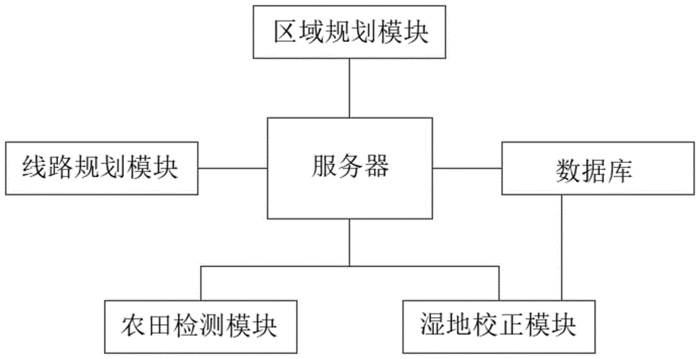
Fig. 1 is a functional block diagram of the present invention.
Detailed Description
The technical solutions of the present invention will be clearly and completely described in connection with the embodiments, and it is obvious that the described embodiments are only some embodiments of the present invention, not all embodiments. All other embodiments, which can be made by those skilled in the art based on the embodiments of the invention without making any inventive effort, are intended to be within the scope of the invention.
As shown in fig. 1, the agricultural non-point source pollution monitoring system based on the full spectrum water quality analyzer comprises a region planning module, a line planning module, a farmland detection module, a wetland correction module, a database and a server;
the regional planning module is used for dividing regions of farmlands to obtain monitoring regions, and the specific method comprises the following steps:
step SA1: acquiring a panoramic photo of a farmland range to be monitored and a regional farmland range, acquiring a picture identification model, identifying farmland boundary lines in the farmland panoramic photo through the picture identification model, manufacturing a farmland distribution map according to the identified farmland boundary lines, and marking a region surrounded by the farmland boundary lines in the farmland distribution map as a single farmland region; the single farmland area refers to a block of farmland;
marking the area of each single farmland area in the farmland distribution map as a unit area, identifying the boundary shape of the single farmland area, marking as a single contour, establishing a contour assignment table, inputting the single contour into the contour assignment table for assignment, obtaining corresponding single contour assignment,
step SA2: the single farmland area is marked as i, i=1, 2, … …, n and n are positive integers, the unit area is marked as Pi, the single contour assignment is marked as Li, and the characteristic vector of the single farmland area is established
Figure BDA0003490990350000051
Establishing a cluster sample set according to the feature vector of a single farmland area>
Figure BDA0003490990350000052
Regarding the feature vector of a single farmland area as an independent cluster, calculating the distance between every two clusters, setting the maximum service radius of a monitoring area, wherein the maximum service radius is set by an expert group according to the analysis capability of a full spectrum water quality analyzer and the farmland drainage condition, combining two clusters closest to each other into a new cluster, and marking the new cluster as a combined cluster;
step SA3: calculating the distance between the combined cluster and other clusters, and combining the two corresponding clusters when the minimum distance between the combined cluster and the other clusters is smaller than the maximum service radius, so as to form a new combined cluster again;
step SA4: and (3) repeating the step (SA 3) until the minimum distance between the combined cluster and other clusters is not smaller than the maximum service radius, stopping repeating the step (SA 3), and marking the corresponding combined cluster as a monitoring area.
When the obtained boundary shape is subjected to de-duplication, only specific shapes are compared, specific size values are not concerned, equal-proportion scaling comparison can be performed, and the existing shape de-duplication algorithm can be used for de-duplication.
The method for acquiring the picture recognition model is to directly select from the existing picture recognition models according to the recognition requirement of the actual picture, because the models for picture contour extraction are quite large in the network, and time and labor are not required to be wasted for building training.
In one embodiment, if the farmland distribution map can be obtained directly by the relevant departments, the farmland distribution map can be directly used without making the farmland distribution map.
The method for establishing the profile assignment table comprises the following steps:
obtaining the boundary shape of the current farmland from the Internet, de-duplicating the obtained boundary shape, and marking the de-duplicated boundary shape with corresponding geographic labels according to geographic areas, wherein one boundary shape may exist in a plurality of geographic areas, so that one boundary shape may have a plurality of different geographic labels; marking the boundary shape marked with the geographic label as a classification boundary, integrating the classification boundary into a statistical table, setting corresponding assignment for each classification boundary in the statistical table, and marking the statistical table after assignment as a contour assignment table.
In one embodiment, the method of setting the corresponding assignment for each classification boundary in the statistical table may be manually assigned, mainly according to the influence of the shape of the classification boundary when a plurality of classification boundaries are subsequently combined.
In one embodiment, the method of setting a corresponding assignment for each classification boundary in the statistical table is: setting a plurality of standard shapes, setting corresponding assignment for each standard shape, acquiring an existing similarity model, calculating the similarity between all classification boundaries and each standard shape, selecting the highest similarity between the classification boundaries and the plurality of standard shapes as an assignment standard, marking identification tags of the corresponding standard shapes, establishing a similarity assignment table of the corresponding standard shapes, inputting the similarity of the classification boundaries into the corresponding similarity assignment table, and matching the similarity to the corresponding classification boundary assignment.
The method for establishing the similarity assignment table corresponding to the standard shape is to set different similarity intervals according to the assignment of the standard shape, and each similarity interval is provided with a corresponding assignment.
The line planning module is used for planning a water flow path of a farmland in the monitoring area, and the specific method comprises the following steps:
identifying adjacent main ditches of a monitoring area in a farmland distribution map, acquiring water outlets of farmlands in the monitoring area, setting a coordinate system in the monitoring area, marking the coordinates of all the water outlets of the farmlands, marking the area between the main ditches and the monitoring area as a buffer area, acquiring the size information of a wetland detection area, setting a wetland standard block according to the acquired size information of the wetland detection area, wherein the wetland standard block is a representative block which is set according to the size of the wetland detection area and is represented in the buffer area, placing the wetland standard block at any position in the buffer area, acquiring the total distance from the water outlets of the farmlands in the monitoring area to the wetland standard block, and enabling the water channel route of a water flow which is indicated by the route from the water outlets of the farmlands to the wetland standard block to directly pass through other farmlands;
changing the position of a wetland standard block in a buffer zone, recalculating the total route distance between a water outlet of a farmland in a monitoring zone and the wetland standard block until the total route distance corresponding to all positions of the wetland standard block in the buffer zone is obtained, arranging the obtained total route distances according to the sequence from small to large, marking the position of the wetland standard block corresponding to the first total route distance as a fixed point position, setting a wetland detection zone at the fixed point position, communicating the water outlet of the farmland in the monitoring zone with the wetland detection zone, and communicating the wetland detection zone with a main ditch.
The farmland detection module is used for detecting the water quality of the farmland in the monitoring area, and the concrete method comprises the following steps:
a full spectrum water quality analyzer is arranged at the water outlet of each farmland in the monitoring area, water quality data of the corresponding farmland are collected in real time through the full spectrum water quality analyzer, the collected water quality data are marked with corresponding farmland labels, and the water quality data marked with the farmland labels are sent to the corresponding wetland correction modules;
the wetland correction module is used for correcting water quality data acquired by the full-spectrum water quality analyzer, and the specific method comprises the following steps:
setting a collaborative correction device in a wetland detection area, acquiring acquisition data of the collaborative correction device in real time, wherein the acquisition data comprises collaborative data and daily spectrum data, the daily spectrum data is data acquired by a full spectrum water quality analyzer in the collaborative correction device when the standard detection device does not acquire the data, the collaborative data comprises collaborative spectrum data and standard data, the standard data is data acquired by the standard detection device in the collaborative correction device, the acquired data are of different types because the standard detection device does not acquire the data in real time, the collaborative spectrum data is data acquired by the full spectrum water quality analyzer in the collaborative correction device when the standard detection device acquires the data, a correction model is established according to the collaborative data, the correction model is established based on a CNN network or a DNN network, the collaborative data is used as a training set for training, namely the collaborative spectrum data in the collaborative data is used as input data, and the standard data in the collaborative data is used as output data for training; the correction model is relearned in real time through the cooperative data collected by the cooperative correction device;
and receiving water quality data transmitted by the farmland detection module, correcting the received water quality data through a correction model, marking the corrected water quality data as farmland monitoring data, and transmitting the farmland monitoring data to a database for storage.
The method for setting the cooperative correction device in the wetland detection area comprises the following steps:
the water quality detection device based on the international method is obtained and marked as a standard detection device, the standard detection device is detected by using a wet chemical analysis method, the detection result with high precision is generally measured once in four hours, and the existing detection device with the same function can be used; and a full spectrum water quality analyzer is arranged adjacent to the standard detection device, and the standard detection device and the full spectrum water quality analyzer are integrated into a cooperative correction device.
The above formulas are all formulas with dimensions removed and numerical values calculated, the formulas are formulas which are obtained by acquiring a large amount of data and performing software simulation to obtain the closest actual situation, and preset parameters and preset thresholds in the formulas are set by a person skilled in the art according to the actual situation or are obtained by simulating a large amount of data.
The working principle of the invention is as follows: dividing the farmland into areas by an area planning module to obtain a monitoring area, and setting a wetland detection area by a line planning module according to the obtained monitoring area; the farmland detection module detects the water quality of the farmland in the monitoring area and sends the collected water quality data to the corresponding wetland correction module; the wetland correction module corrects water quality data acquired by the full-spectrum water quality analyzer, a cooperative correction device is arranged in a wetland detection area, acquired data of the cooperative correction device are acquired in real time, the acquired data comprise cooperative data and daily spectrum data, the cooperative data comprise cooperative spectrum data and standard data, a correction model is established according to the cooperative data, and the correction model is relearned in real time through the cooperative data acquired by the cooperative correction device; and receiving water quality data transmitted by the farmland detection module, correcting the received water quality data through a correction model, marking the corrected water quality data as farmland monitoring data, and transmitting the farmland monitoring data to a database for storage.
The above embodiments are only for illustrating the technical method of the present invention and not for limiting the same, and it should be understood by those skilled in the art that the technical method of the present invention may be modified or substituted without departing from the spirit and scope of the technical method of the present invention.

Claims (3)

1.基于全光谱水质分析仪的农业面源污染监测系统,其特征在于,包括区域规划模块、线路规划模块、农田检测模块、湿地校正模块、数据库和服务器;1. An agricultural non-point source pollution monitoring system based on a full-spectrum water quality analyzer, characterized in that it includes a regional planning module, a route planning module, a farmland detection module, a wetland correction module, a database, and a server; 通过区域规划模块进行农田的区域划分,获得监测区域,线路规划模块根据获得的监测区域设置湿地检测区;农田检测模块对监测区域内农田的水质进行检测,并将采集的水质数据发送到对应的湿地校正模块;The regional planning module divides farmland into monitoring areas, and the route planning module sets up wetland detection zones based on the obtained monitoring areas. The farmland detection module detects the water quality of farmland within the monitoring area and sends the collected water quality data to the corresponding wetland correction module. 湿地校正模块用于对农田检测模块采集的水质数据进行校正,具体方法包括:The wetland correction module is used to correct the water quality data collected by the farmland monitoring module. Specific methods include: 在湿地检测区设置协同校正装置,实时获取协同校正装置的采集数据,采集数据包括协同数据和日常光谱数据,协同数据包括协同光谱数据和标准数据,根据协同数据建立校正模型,并实时通过协同校正装置采集的协同数据对校正模型进行再学习;A collaborative calibration device is set up in the wetland detection area to acquire data collected by the collaborative calibration device in real time. The acquired data includes collaborative data and daily spectral data. The collaborative data includes collaborative spectral data and standard data. A calibration model is established based on the collaborative data, and the calibration model is relearned in real time using the collaborative data collected by the collaborative calibration device. 接收农田检测模块传输的水质数据,通过校正模型对接收的水质数据进行校正,将校正后的水质数据标记为农田监测数据,将农田监测数据发送到数据库进行保存;The system receives water quality data transmitted from the farmland monitoring module, corrects the received water quality data using a calibration model, marks the corrected water quality data as farmland monitoring data, and sends the farmland monitoring data to the database for storage. 区域规划模块的工作方法包括:The working methods of the regional planning module include: 步骤SA1:获取单一农田区域,识别各个单一农田区域的面积,标记为单元面积,获取单一农田区域的边界形状,标记为单一轮廓,建立轮廓赋值表,将单一轮廓输入到轮廓赋值表中进行赋值,获得对应的单一轮廓赋值;Step SA1: Obtain a single farmland area, identify the area of each single farmland area and mark it as a unit area, obtain the boundary shape of the single farmland area and mark it as a single contour, establish a contour assignment table, input the single contour into the contour assignment table for assignment, and obtain the corresponding single contour assignment. 步骤SA2:建立单一农田区域的特征向量,根据单一农田区域的特征向量建立聚类样本集合,将单一农田区域的特征向量视为一个独立的聚类簇,计算两两聚类簇之间的距离,设置监测区域的最大服务半径,将距离最近的两个聚类簇合并为一个新的聚类簇,将新的聚类簇标记为合并聚类簇;Step SA2: Establish the feature vector of a single farmland area, establish a cluster sample set based on the feature vector of the single farmland area, regard the feature vector of the single farmland area as an independent cluster, calculate the distance between each pair of clusters, set the maximum service radius of the monitoring area, merge the two closest clusters into a new cluster, and mark the new cluster as the merged cluster. 步骤SA3:计算合并聚类簇与其他聚类簇之间的距离,当合并聚类簇与其他聚类簇之间的最小距离小于最大服务半径时,将对应的两个聚类簇进行合并,再次形成一个新的合并聚类簇;Step SA3: Calculate the distance between the merged cluster and other clusters. When the minimum distance between the merged cluster and other clusters is less than the maximum service radius, merge the two corresponding clusters to form a new merged cluster. 步骤SA4:重复步骤SA3,直到合并聚类簇与其他聚类簇之间的最小距离不小于最大服务半径时,停止重复步骤SA3,将对应的合并聚类簇标记为监测区域;Step SA4: Repeat step SA3 until the minimum distance between the merged cluster and other clusters is not less than the maximum service radius. Then stop repeating step SA3 and mark the corresponding merged cluster as the monitoring area. 获取单一农田区域的方法包括:Methods for obtaining a single farmland area include: 获取需要进行监测的农田范围,区域农田范围的全景照片,获取图片识别模型,通过图片识别模型识别农田全景照片中的农田边界线,根据识别的农田边界线制作农田分布图,将农田分布图中农田边界线包围的区域标记为单一农田区域;Obtain the farmland area to be monitored, panoramic photos of the farmland area, obtain image recognition model, identify farmland boundary lines in the panoramic photos of farmland using the image recognition model, create farmland distribution map based on the identified farmland boundary lines, and mark the area enclosed by the farmland boundary lines in the farmland distribution map as a single farmland area. 建立轮廓赋值表的方法包括:Methods for creating a contour assignment table include: 从互联网中获取当前农田具有的边界形状,并对获取的边界形状进行去重,将去重后的边界形状根据地理区域打上对应的地理标签,打上地理标签的边界形状标记为分类边界,将分类边界整合到一张统计表格中,为统计表格中的每个分类边界设置对应的赋值,将赋值后的统计表格标记为轮廓赋值表;Obtain the current farmland boundary shape from the Internet, remove duplicate boundary shapes, assign corresponding geographical labels to the deduplicated boundary shapes according to geographical regions, mark the boundary shapes with geographical labels as category boundaries, integrate the category boundaries into a statistical table, assign corresponding values to each category boundary in the statistical table, and mark the statistical table after assignment as a contour assignment table. 为统计表格中的每个分类边界设置对应的赋值的方法为:The method for assigning corresponding values to each category boundary in the statistical table is as follows: 设置若干个标准形状,并为每个标准形状设置对应的赋值,获取相似度模型,计算所有的分类边界与每个标准形状之间的相似度,选取分类边界与若干个标准形状中最高的相似度作为赋值标准,并打上对应标准形状的识别标签,建立对应标准形状的相似度赋值表,将分类边界的相似度输入到对应的相似度赋值表中,匹配到对应的分类边界赋值;Set up several standard shapes and assign corresponding values to each standard shape. Obtain a similarity model, calculate the similarity between all classification boundaries and each standard shape, select the highest similarity between the classification boundary and several standard shapes as the assignment standard, and mark the corresponding standard shape with an identification label. Establish a similarity assignment table for the corresponding standard shape, input the similarity of the classification boundary into the corresponding similarity assignment table, and match the corresponding classification boundary for assignment. 线路规划模块的工作方法包括:The working methods of the route planning module include: 识别农田分布图中监测区域的相邻主水渠,获取监测区域内农田的排水口,在监测区域内设置坐标系,标记各个农田排水口的坐标,将主水渠与监测区域之间的区域标记为缓冲区,获取湿地检测区的尺寸信息,根据获取的湿地检测区尺寸信息设置湿地标准块,将湿地标准块放置在缓冲区内的任意位置上,获取监测区域内农田的排水口到湿地标准块之间的路线总距离;Identify adjacent main irrigation canals in the monitoring area of the farmland distribution map, obtain the drainage outlets of farmland in the monitoring area, set up a coordinate system in the monitoring area, mark the coordinates of each farmland drainage outlet, mark the area between the main irrigation canal and the monitoring area as a buffer zone, obtain the size information of the wetland detection area, set up wetland standard blocks according to the obtained wetland detection area size information, place the wetland standard blocks at any position in the buffer zone, and obtain the total route distance between the drainage outlets of farmland in the monitoring area and the wetland standard blocks. 改变湿地标准块在缓冲区内的位置,重新计算监测区域内农田的排水口到湿地标准块之间的路线总距离,直到获得湿地标准块在缓冲区内所有位置上对应的路线总距离,将获得路线总距离按照由小到大的顺序进行排列,将排列第一的路线总距离对应的湿地标准块位置标记为定点位置,将湿地检测区设置在定点位置。Change the position of the wetland standard block within the buffer zone, recalculate the total route distance from the drainage outlet of farmland within the monitoring area to the wetland standard block, until the total route distance corresponding to all positions of the wetland standard block within the buffer zone is obtained. Arrange the obtained total route distances in ascending order, mark the position of the wetland standard block corresponding to the first total route distance as the fixed point position, and set the wetland detection area at the fixed point position. 2.根据权利要求1所述的基于全光谱水质分析仪的农业面源污染监测系统,其特征在于,农田检测模块的工作方法包括:2. The agricultural non-point source pollution monitoring system based on a full-spectrum water quality analyzer according to claim 1, characterized in that the working method of the farmland detection module includes: 在监测区域内每个农田的排水口处设置全光谱水质分析仪,通过全光谱水质分析仪实时采集对应农田的水质数据,并将采集的水质数据打上对应的农田标签。A full-spectrum water quality analyzer is installed at the drainage outlet of each farmland within the monitoring area. The water quality data of the corresponding farmland is collected in real time by the full-spectrum water quality analyzer, and the collected water quality data is labeled with the corresponding farmland. 3.根据权利要求1所述的基于全光谱水质分析仪的农业面源污染监测系统,其特征在于,在湿地检测区设置协同校正装置的方法包括:3. The agricultural non-point source pollution monitoring system based on a full-spectrum water quality analyzer according to claim 1, characterized in that the method of setting up a collaborative correction device in the wetland detection area includes: 获取基于国际法的水质检测装置,标记为标准检测装置,与标准检测装置相邻设置一个全光谱水质分析仪,将标准检测装置与全光谱水质分析仪整合为协同校正装置。Obtain a water quality testing device based on international law, mark it as a standard testing device, set up a full-spectrum water quality analyzer adjacent to the standard testing device, and integrate the standard testing device and the full-spectrum water quality analyzer into a collaborative calibration device.
CN202210095885.2A 2022-01-26 2022-01-26 Agricultural non-point source pollution monitoring system based on full spectrum water quality analyzer Active CN114486764B (en)

Priority Applications (1)

Application Number Priority Date Filing Date Title
CN202210095885.2A CN114486764B (en) 2022-01-26 2022-01-26 Agricultural non-point source pollution monitoring system based on full spectrum water quality analyzer

Applications Claiming Priority (1)

Application Number Priority Date Filing Date Title
CN202210095885.2A CN114486764B (en) 2022-01-26 2022-01-26 Agricultural non-point source pollution monitoring system based on full spectrum water quality analyzer

Publications (2)

Publication Number Publication Date
CN114486764A CN114486764A (en) 2022-05-13
CN114486764B true CN114486764B (en) 2023-06-06

Family

ID=81476810

Family Applications (1)

Application Number Title Priority Date Filing Date
CN202210095885.2A Active CN114486764B (en) 2022-01-26 2022-01-26 Agricultural non-point source pollution monitoring system based on full spectrum water quality analyzer

Country Status (1)

Country Link
CN (1) CN114486764B (en)

Families Citing this family (4)

* Cited by examiner, † Cited by third party
Publication number Priority date Publication date Assignee Title
CN115170756A (en) * 2022-08-18 2022-10-11 中国矿业大学 Real-time monitoring system for fracture process of rock sample containing pore canal
CN115684532B (en) * 2022-12-30 2023-05-12 正大农业科学研究有限公司 Water quality monitoring method, device, system, electronic equipment and storage medium
CN116310893B (en) * 2023-02-22 2023-09-19 中关村科学城城市大脑股份有限公司 A drone-based water pollution collection and identification method and system
CN117808173B (en) * 2024-02-29 2024-04-30 四川省水利科学研究院 Paddy field fertility detection method, related product and planting method based on related product

Citations (2)

* Cited by examiner, † Cited by third party
Publication number Priority date Publication date Assignee Title
CN113588572A (en) * 2021-08-04 2021-11-02 广州市华南自然资源科学技术研究院 Intelligent management system for farmland heavy metal on-line detection correction model
CN113869104A (en) * 2021-08-04 2021-12-31 山东商务职业学院 Agricultural environment monitoring system based on big data

Family Cites Families (19)

* Cited by examiner, † Cited by third party
Publication number Priority date Publication date Assignee Title
WO2012090235A1 (en) * 2010-12-31 2012-07-05 Geotechnos S.R.L. Integrated method and system for detecting and elaborating environmental and terrestrial data
US10520482B2 (en) * 2012-06-01 2019-12-31 Agerpoint, Inc. Systems and methods for monitoring agricultural products
JP6031491B2 (en) * 2014-11-21 2016-11-24 ジオサーフ株式会社 Field guidance system, field guidance method, software, and storage medium storing software
CN106485655A (en) * 2015-09-01 2017-03-08 张长隆 A kind of taken photo by plane map generation system and method based on quadrotor
US11044842B2 (en) * 2015-12-03 2021-06-29 Mogens Max Sophus Edzard Graf Piessen Path planning for area coverage
CN105758806B (en) * 2016-02-04 2020-01-17 中国农业科学院农业资源与农业区划研究所 Remote sensing monitoring method of mulching farmland based on spectral characteristics
CN106355334A (en) * 2016-08-30 2017-01-25 中国农业大学 Farmland construction area determining method
CN107957357B (en) * 2018-01-18 2021-02-02 浙江清环智慧科技有限公司 Automatic sampling method and device for drainage pipeline water quality
IT201800003790A1 (en) * 2018-03-20 2019-09-20 Skyx Ltd Management of a fleet of aerial spraying vehicles
CN109146889B (en) * 2018-07-13 2021-11-19 洛阳中科龙网创新科技有限公司 Farmland boundary extraction method based on high-resolution remote sensing image
CN109631903A (en) * 2019-01-04 2019-04-16 丰疆智慧农业股份有限公司 Cereal handles automated driving system and its automatic Pilot method and paths planning method
US11778934B2 (en) * 2019-07-02 2023-10-10 Bear Flag Robotics, Inc. Agricultural lane following
IT201900024844A1 (en) * 2019-12-19 2021-06-19 Stiga S P A In Breve Anche St S P A SYSTEM AND RELATIVE METHOD OF MONITORING OF LANDS
CN111062361B (en) * 2019-12-27 2023-06-20 中水北方勘测设计研究有限责任公司 River and lake shoreline sand production monitoring and analyzing method and device
CN113343740B (en) * 2020-03-02 2022-05-06 阿里巴巴集团控股有限公司 Form detection method, device, equipment and storage medium
CN111380813B (en) * 2020-03-20 2022-11-29 合肥工业大学 A portable multi-quality non-destructive testing device and testing method for wheat seeds
CN112734694A (en) * 2020-12-19 2021-04-30 闫耀伟 Water quality monitoring method based on big data
CN112926915B (en) * 2021-02-07 2023-04-18 广东白云学院 Logistics big data statistics management system
CN113040034B (en) * 2021-03-26 2023-10-24 西京学院 Water-saving irrigation control system and control method

Patent Citations (2)

* Cited by examiner, † Cited by third party
Publication number Priority date Publication date Assignee Title
CN113588572A (en) * 2021-08-04 2021-11-02 广州市华南自然资源科学技术研究院 Intelligent management system for farmland heavy metal on-line detection correction model
CN113869104A (en) * 2021-08-04 2021-12-31 山东商务职业学院 Agricultural environment monitoring system based on big data

Also Published As

Publication number Publication date
CN114486764A (en) 2022-05-13

Similar Documents

Publication Publication Date Title
CN114486764B (en) Agricultural non-point source pollution monitoring system based on full spectrum water quality analyzer
CN113962659B (en) A smart grid big data information management system and method based on cloud computing
WO2022184088A1 (en) Flood sensitivity risk assessment method based on ensemble learning
CN108278491B (en) A kind of method and system that discovery drainage pipeline networks is operating abnormally
CN108333314B (en) Intelligent air pollution monitoring system
CN112906694A (en) Reading correction system and method for inclined pointer instrument image of transformer substation
CN117538503A (en) Real-time intelligent soil pollution monitoring system and method
CN108918526A (en) A kind of chips defect detection method of flexibility IC package base plate line
CN117469603B (en) Multi-water-plant water supply system pressure optimal control method based on big data learning
CN114639064B (en) Water level identification method and device
CN108804805A (en) A method of automatically extracting a plurality of river basins exit point
CN103955583B (en) Method for determining threshold value of urban built-up area extracted through nighttime light data
CN117909905B (en) Hydrologic station multidimensional time sequence anomaly identification method and device considering hydrologic connection
CN117610972B (en) Green building digital management system and method based on artificial intelligence
CN105467100B (en) County's region soil based on remote sensing and GIS corrodes space-time dynamic monitoring method
CN114417981A (en) Intelligent river length patrol system
CN118521126B (en) Smart power grid planning method and system based on data analysis
CN119691412B (en) River channel measurement data preprocessing method based on artificial intelligence
CN106650746A (en) Transformer station pointer type instrument identification method based on angle step length
CN118226816B (en) A component size quality control system and method
CN112489026B (en) Asphalt pavement disease detection method based on multi-branch parallel convolutional neural network
CN120522145B (en) Water pollution monitoring system and methods
CN120338187A (en) An intelligent agricultural irrigation water consumption prediction method and system
CN109359637B (en) The reading method of pointer meter based on machine vision
CN119848410A (en) Visibility forecast mode evaluation method and system

Legal Events

Date Code Title Description
PB01 Publication
PB01 Publication
SE01 Entry into force of request for substantive examination
GR01 Patent grant
GR01 Patent grant