CN111247792A - Control method of unmanned aerial vehicle, unmanned aerial vehicle and computer readable storage medium - Google Patents
Control method of unmanned aerial vehicle, unmanned aerial vehicle and computer readable storage medium Download PDFInfo
- Publication number
- CN111247792A CN111247792A CN201980005063.7A CN201980005063A CN111247792A CN 111247792 A CN111247792 A CN 111247792A CN 201980005063 A CN201980005063 A CN 201980005063A CN 111247792 A CN111247792 A CN 111247792A
- Authority
- CN
- China
- Prior art keywords
- line
- information
- reference identification
- preset
- image
- Prior art date
- Legal status (The legal status is an assumption and is not a legal conclusion. Google has not performed a legal analysis and makes no representation as to the accuracy of the status listed.)
- Granted
Links
Images


Classifications
-
- H—ELECTRICITY
- H04—ELECTRIC COMMUNICATION TECHNIQUE
- H04N—PICTORIAL COMMUNICATION, e.g. TELEVISION
- H04N23/00—Cameras or camera modules comprising electronic image sensors; Control thereof
- H04N23/60—Control of cameras or camera modules
- H04N23/695—Control of camera direction for changing a field of view, e.g. pan, tilt or based on tracking of objects
-
- G—PHYSICS
- G05—CONTROLLING; REGULATING
- G05D—SYSTEMS FOR CONTROLLING OR REGULATING NON-ELECTRIC VARIABLES
- G05D1/00—Control of position, course, altitude or attitude of land, water, air or space vehicles, e.g. using automatic pilots
- G05D1/08—Control of attitude, i.e. control of roll, pitch, or yaw
- G05D1/0808—Control of attitude, i.e. control of roll, pitch, or yaw specially adapted for aircraft
-
- G—PHYSICS
- G05—CONTROLLING; REGULATING
- G05D—SYSTEMS FOR CONTROLLING OR REGULATING NON-ELECTRIC VARIABLES
- G05D1/00—Control of position, course, altitude or attitude of land, water, air or space vehicles, e.g. using automatic pilots
- G05D1/10—Simultaneous control of position or course in three dimensions
- G05D1/101—Simultaneous control of position or course in three dimensions specially adapted for aircraft
-
- G—PHYSICS
- G06—COMPUTING OR CALCULATING; COUNTING
- G06V—IMAGE OR VIDEO RECOGNITION OR UNDERSTANDING
- G06V20/00—Scenes; Scene-specific elements
- G06V20/50—Context or environment of the image
- G06V20/56—Context or environment of the image exterior to a vehicle by using sensors mounted on the vehicle
Landscapes
- Engineering & Computer Science (AREA)
- Physics & Mathematics (AREA)
- General Physics & Mathematics (AREA)
- Multimedia (AREA)
- Aviation & Aerospace Engineering (AREA)
- Radar, Positioning & Navigation (AREA)
- Remote Sensing (AREA)
- Automation & Control Theory (AREA)
- Signal Processing (AREA)
- Theoretical Computer Science (AREA)
- Image Analysis (AREA)
- Control Of Position, Course, Altitude, Or Attitude Of Moving Bodies (AREA)
Abstract
一种无人机的控制方法、无人机及计算机可读存储介质,其中,所述无人机包括拍摄装置,所述方法包括:在所述无人机沿空间中预置的参考标识线移动的过程中,根据所述拍摄装置输出的所述参考标识线的图像识别所述参考标识线的特征信息;当所述特征信息满足预设的第一特征条件时,控制所述无人机执行所述特征信息所指示的动作任务。本发明实施例不仅可以通过识别标识线的特征信息准确获取动作任务,还可以通过将动作任务与标识线的特征信息融合,有效降低巡线系统布置的成本和复杂度。
A control method for a drone, the drone, and a computer-readable storage medium are disclosed. The drone includes a camera device. The method includes: during the movement of the drone along a preset reference marker line in space, identifying feature information of the reference marker line based on an image of the reference marker line output by the camera device; and when the feature information meets a preset first feature condition, controlling the drone to execute an action task indicated by the feature information. This invention not only accurately obtains action tasks by identifying the feature information of the marker line, but also effectively reduces the cost and complexity of deploying a line-following system by fusing the action task with the feature information of the marker line.
Description
技术领域technical field
本发明涉及控制技术领域,尤其涉及一种无人机的控制方法、无人机及计算机可读存储介质。The present invention relates to the technical field of control, and in particular, to a control method of an unmanned aerial vehicle, an unmanned aerial vehicle and a computer-readable storage medium.
背景技术Background technique
巡线控制在机器人行业中具有广泛的应用。巡线控制通常需要一条在空间设置的标识线作为参考,同时需要一套检测设备对标识线和机器人当前的位置进行检测,以根据机器人和标识线两者之间的关系计算控制输出,从而达到使机器人沿给定标识线运动的目的。Line-following control has a wide range of applications in the robotics industry. Line patrol control usually requires a marking line set in space as a reference, and a set of detection equipment is required to detect the marking line and the current position of the robot, so as to calculate the control output according to the relationship between the robot and the marking line, so as to achieve The purpose of making the robot move along the given marking line.
目前,为实现机器人在巡线控制中执行不同动作,例如掉头、转弯等,巡线系统需要辅以一套路标系统。路标系统用于通过路标来标记路口、线的有关信息,通常可以采用近场通信(Near Field Communication,NFC)感应圈、二维码、特殊图案等形式来设置路标。机器人通过检测行进前方的路标来获取前方道路信息,从而执行相应动作。但是,在巡线系统中增设路标系统,会增加巡线系统布置的成本和复杂度;并且路标具有混淆性,容易导致机器人因为观察角度、观察距离等问题产生误判。At present, in order to realize the robot to perform different actions in the line inspection control, such as U-turn, turning, etc., the line inspection system needs to be supplemented by a road marking system. The road sign system is used to mark the relevant information of intersections and lines through road signs. Usually, road signs can be set in the form of near field communication (Near Field Communication, NFC) induction loops, two-dimensional codes, special patterns, and the like. The robot obtains the road information ahead by detecting the road signs ahead of it, so as to perform corresponding actions. However, adding a road sign system to the line inspection system will increase the cost and complexity of the line inspection system layout; and the road signs are confusing, which may easily lead to misjudgment by the robot due to problems such as observation angle and observation distance.
发明内容SUMMARY OF THE INVENTION
本发明实施例公开了一种无人机的控制方法、无人机及计算机可读存储介质,不仅可以通过识别标识线的特征信息准确获取动作任务,还可以通过将动作任务与标识线的特征信息融合,有效降低巡线系统布置的成本和复杂度。The embodiment of the present invention discloses a control method of an unmanned aerial vehicle, an unmanned aerial vehicle and a computer-readable storage medium, which can not only accurately acquire an action task by identifying the feature information of a marking line, but also can obtain an action task by comparing the action task with the feature of the marking line. Information fusion can effectively reduce the cost and complexity of line inspection system layout.
本发明实施例第一方面公开了一种无人机的控制方法,其中,所述无人机包括拍摄装置,所述方法包括:A first aspect of the embodiments of the present invention discloses a control method for an unmanned aerial vehicle, wherein the unmanned aerial vehicle includes a photographing device, and the method includes:
在所述无人机沿空间中预置的参考标识线移动的过程中,根据所述拍摄装置输出的所述参考标识线的图像识别所述参考标识线的特征信息;During the movement of the unmanned aerial vehicle along the reference identification line preset in the space, the feature information of the reference identification line is identified according to the image of the reference identification line output by the photographing device;
当所述特征信息满足预设的第一特征条件时,控制所述无人机执行所述特征信息所指示的动作任务。When the feature information satisfies a preset first feature condition, the UAV is controlled to perform the action task indicated by the feature information.
本发明实施例第二方面公开了一种无人机,其中,所述无人机包括拍摄装置,所述无人机还包括:存储器和处理器,A second aspect of the embodiments of the present invention discloses an unmanned aerial vehicle, wherein the unmanned aerial vehicle includes a photographing device, and the unmanned aerial vehicle further includes: a memory and a processor,
所述存储器,用于存储程序指令;the memory for storing program instructions;
所述处理器,用于执行所述存储器存储的程序指令,当所述程序指令被执行时,所述处理器用于:The processor is configured to execute program instructions stored in the memory, and when the program instructions are executed, the processor is configured to:
在所述无人机沿空间中预置的参考标识线移动的过程中,根据所述拍摄装置输出的所述参考标识线的图像识别所述参考标识线的特征信息;During the movement of the unmanned aerial vehicle along the reference identification line preset in the space, the feature information of the reference identification line is identified according to the image of the reference identification line output by the photographing device;
当所述特征信息满足预设的第一特征条件时,控制所述无人机执行所述特征信息所指示的动作任务。When the feature information satisfies a preset first feature condition, the UAV is controlled to perform the action task indicated by the feature information.
本发明实施例第三方面公开了一种计算机可读存储介质,所述计算机可读存储介质中存储有计算机程序,所述计算机程序被处理器执行时实现如上述第一方面所述方法的步骤。A third aspect of the embodiments of the present invention discloses a computer-readable storage medium, where a computer program is stored in the computer-readable storage medium, and when the computer program is executed by a processor, the steps of the method described in the first aspect above are implemented .
本发明实施例通过在无人机沿参考标识线移动的过程中,根据参考标识线的图像识别参考标识线的特征信息,并在特征信息满足预设的特征条件时,控制无人机执行特征信息所指示的动作任务,不仅可以通过识别标识线的特征信息准确获取动作任务,还可以通过将动作任务与标识线的特征信息融合,有效降低巡线系统布置的成本和复杂度。In the embodiment of the present invention, during the movement of the drone along the reference marking line, the feature information of the reference marking line is recognized according to the image of the reference marking line, and when the feature information satisfies the preset feature condition, the drone is controlled to execute the feature The action task indicated by the information can not only accurately obtain the action task by identifying the feature information of the marking line, but also effectively reduce the cost and complexity of the line patrol system layout by fusing the action task with the feature information of the marking line.
附图说明Description of drawings
为了更清楚地说明本发明实施例中的技术方案,下面将对实施例中所需要使用的附图作简单地介绍,显而易见地,下面描述中的附图仅仅是本发明的一些实施例,对于本领域普通技术人员来讲,在不付出创造性劳动性的前提下,还可以根据这些附图获得其他的附图。In order to illustrate the technical solutions in the embodiments of the present invention more clearly, the following briefly introduces the drawings required in the embodiments. Obviously, the drawings in the following description are only some embodiments of the present invention. For those of ordinary skill in the art, other drawings can also be obtained from these drawings without any creative effort.
图1是本发明实施例公开的一种无人机的结构示意图;1 is a schematic structural diagram of an unmanned aerial vehicle disclosed in an embodiment of the present invention;
图2是本发明实施例公开的一种无人机的巡线控制的场景示意图;FIG. 2 is a schematic diagram of a scene of the line patrol control of an unmanned aerial vehicle disclosed in an embodiment of the present invention;
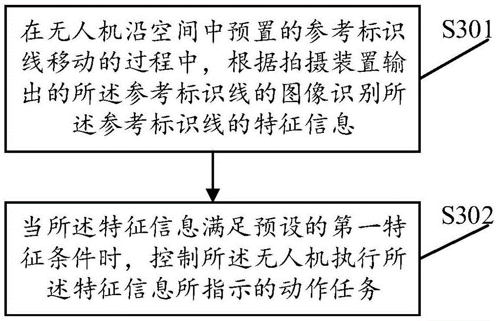
图3是本发明实施例公开的一种无人机的控制方法的流程示意图;3 is a schematic flowchart of a method for controlling an unmanned aerial vehicle disclosed in an embodiment of the present invention;
图4是本发明实施例公开的一种无人机沿参考标识线移动的示意图;4 is a schematic diagram of a UAV moving along a reference marking line disclosed in an embodiment of the present invention;
图5是本发明实施例公开的另一种无人机的结构示意图。FIG. 5 is a schematic structural diagram of another unmanned aerial vehicle disclosed in an embodiment of the present invention.
具体实施方式Detailed ways
下面将结合本发明实施例中的附图,对本发明实施例中的技术方案进行清楚、完整地描述。显然,所描述的实施例仅仅是本发明一部分实施例,而不是全部的实施例。基于本发明中的实施例,本领域普通技术人员在没有作出创造性劳动前提下所获得的所有其他实施例,都属于本发明保护的范围。The technical solutions in the embodiments of the present invention will be clearly and completely described below with reference to the accompanying drawings in the embodiments of the present invention. Obviously, the described embodiments are only some, but not all, embodiments of the present invention. Based on the embodiments of the present invention, all other embodiments obtained by those of ordinary skill in the art without creative efforts shall fall within the protection scope of the present invention.
下面结合附图,对本发明的一些实施方式作详细说明。在不冲突的情况下,下述的实施例及实施例中的特征可以相互组合。Some embodiments of the present invention will be described in detail below with reference to the accompanying drawings. The embodiments described below and features in the embodiments may be combined with each other without conflict.
本发明实施例中,无人机可以包括拍摄装置,其中,拍摄装置可以承载在无人机的机身上。所述拍摄装置可以直接承载在无人机的机身上,另外,在某些实施例中,所述无人机还包括云台,其中,所述拍摄装置安装在云台上,所述拍摄装置可以通过云台承载无人机的机身上。拍摄装置可以是相机、摄像机、具有拍照功能的手机等。所述云台带动所述拍摄装置绕偏航轴、横滚轴和俯仰轴中的一个或者多个轴线进行旋转以调整拍摄装置的拍摄姿态。如图1所示,示出了无人机的机身、云台和拍摄装置三者之间的关系,在图1所示的无人机中,云台102安装于无人机的机身101上,而拍摄装置103固定在云台102上。其中,本发明实施例中所述的无人机可以包括无人飞行器、无人车和无人船等。In the embodiment of the present invention, the unmanned aerial vehicle may include a photographing device, wherein the photographing device may be carried on the fuselage of the unmanned aerial vehicle. The photographing device can be directly carried on the fuselage of the UAV. In addition, in some embodiments, the UAV further includes a gimbal, wherein the photographing device is installed on the gimbal, and the photographing device is installed on the gimbal. The device can be carried on the fuselage of the drone through the gimbal. The photographing device may be a camera, a video camera, a mobile phone with a photographing function, or the like. The pan/tilt drives the photographing device to rotate around one or more axes among the yaw axis, the roll axis and the pitch axis to adjust the photographing posture of the photographing device. As shown in FIG. 1 , the relationship between the fuselage, the gimbal and the photographing device of the UAV is shown. In the UAV shown in FIG. 1 , the
如图2所示,用户可以预先在空间中设置参考标识线201,预置的参考标识线用于指示无人机202移动的轨迹;预置的参考标识线可以具有一种或者多种特征信息,以通过参考标识线的特征信息向无人机指示需要完成的动作任务。其中,参考标识线可以是设置在地面上,也可以是设置在空中;所述特征信息包括线型信息、颜色信息、线宽信息、分叉信息、纹理信息和立体信息中的至少一种。在无人机沿预置的参考标识线移动的过程中,无人机控制其配置的拍摄装置针对参考标识线进行拍照,得到参考标识线的图像。进一步地,无人机获取所述拍摄装置输出的参考标识线的图像,并根据参考标识线的图像识别参考标识线的特征信息。当参考标识线的特征信息满足预设的第一特征条件时,控制无人机执行所述特征信息所指示的动作任务。采用上述方式,通过识别标识线的特征信息可以准确获取动作任务,通过将动作任务与标识线的特征信息融合,无人机通过检测参考标识线的特征信息便能确定无人机需要执行的动作任务,可以免除设置指示无人机执行动作任务的路标,可以有效降低巡线系统布置的成本和复杂度。As shown in FIG. 2 , the user can preset a
请参阅图3,为本发明实施例提供的一种无人机的控制方法的流程示意图。本发明实施例中所描述的无人机的控制方法包括如下步骤:Please refer to FIG. 3 , which is a schematic flowchart of a method for controlling an unmanned aerial vehicle according to an embodiment of the present invention. The control method of the UAV described in the embodiment of the present invention includes the following steps:
S301、在无人机沿空间中预置的参考标识线移动的过程中,根据拍摄装置输出的所述参考标识线的图像识别所述参考标识线的特征信息。S301 , during the movement of the drone along the reference mark line preset in space, identify the feature information of the reference mark line according to the image of the reference mark line output by the photographing device.
本发明实施例中,用户预先在空间中设置参考标识线,预置的参考标识线用于指示无人机移动的轨迹;预置的参考标识线可以具有一种或者多种特征信息,以通过参考标识线的特征信息向无人机指示需要完成的动作任务。其中,所述特征信息包括线型信息、颜色信息、线宽信息、分叉信息、纹理信息和立体信息中的至少一种。无人机控制其配置的拍摄装置针对空间中预置的参考标识线进行拍照,得到参考标识线的图像。无人机获取所述拍摄装置输出的参考标识线的图像,并根据参考标识线的图像确定所述无人机的目标路径。具体地,无人机确定参考标识线在所述图像中的位置,并根据参考标识线在所述图像中的位置确定无人机的目标路径。进而,无人机根据所述目标路径控制无人机移动以使无人机沿预置的参考标识线移动。In this embodiment of the present invention, the user pre-sets a reference mark line in space, and the preset reference mark line is used to indicate the trajectory of the UAV moving; the preset reference mark line may have one or more kinds of characteristic information, so that the The feature information of the reference line indicates to the UAV the action task that needs to be completed. Wherein, the feature information includes at least one of line type information, color information, line width information, bifurcation information, texture information and stereoscopic information. The UAV controls its configured photographing device to take pictures of the reference identification line preset in the space, and obtains an image of the reference identification line. The drone acquires the image of the reference marking line output by the photographing device, and determines the target path of the drone according to the image of the reference marking line. Specifically, the drone determines the position of the reference marking line in the image, and determines the target path of the drone according to the position of the reference marking line in the image. Further, the UAV controls the UAV to move according to the target path so that the UAV moves along the preset reference marking line.
在无人机沿预置的参考标识线移动的过程中,无人机控制其配置的拍摄装置针对参考标识线进行拍照,得到参考标识线的图像。进一步地,无人机获取所述拍摄装置输出的参考标识线的图像,并根据参考标识线的图像识别参考标识线的特征信息。其中,无人机可以是每隔预设时间间隔控制其配置的拍摄装置针对参考标识线进行拍照,得到参考标识线的图像。无人机也可以是在接收到控制终端发送的拍照指令之后,控制其配置的拍摄装置针对参考标识线进行拍照,得到参考标识线的图像。During the movement of the UAV along the preset reference identification line, the UAV controls its configured photographing device to take pictures of the reference identification line to obtain an image of the reference identification line. Further, the drone acquires the image of the reference identification line output by the photographing device, and identifies the feature information of the reference identification line according to the image of the reference identification line. Wherein, the UAV may be a photographing device that controls its configuration at preset time intervals to take pictures of the reference identification line to obtain an image of the reference identification line. After receiving the photographing instruction sent by the control terminal, the drone may also control the photographing device configured by the drone to photograph the reference identification line to obtain an image of the reference identification line.
在一实施例中,所述特征信息包括线型信息,无人机根据参考标识线的图像识别参考标识线的特征信息的方式可以为:对参考标识线的图像进行连通域检测处理以获取所述图像中参考标识线的连通域检测结果;然后根据所述图像中参考标识线的连通域检测结果识别参考标识线的线型信息。其中,所述图像中参考标识线的连通域检测结果可以用于指示图像中的参考标识线是否连通,图像中参考标识线的连通域检测结果可以用于确定拍摄装置的拍摄范围内的参考标识线的线型信息。当所述图像中参考标识线的连通域检测结果指示参考标识线连通时,无人机确定参考标识线的线型信息为实线,即拍摄装置的拍摄范围内的参考标识线的线型为实线;当所述图像中参考标识线的连通域检测结果指示参考标识线不连通时,无人机确定参考标识线的线型信息为虚线,即拍摄装置的拍摄范围内的参考标识线的线型为虚线。In one embodiment, the feature information includes line type information, and the method for the unmanned aerial vehicle to identify the feature information of the reference line according to the image of the reference line may be: performing a connected domain detection process on the image of the reference line to obtain the The connected domain detection result of the reference mark line in the image is obtained; then the line type information of the reference mark line is identified according to the connected domain detection result of the reference mark line in the image. Wherein, the connected domain detection result of the reference mark line in the image can be used to indicate whether the reference mark line in the image is connected, and the connected domain detection result of the reference mark line in the image can be used to determine the reference mark within the shooting range of the photographing device Linetype information for the line. When the connected domain detection result of the reference marker line in the image indicates that the reference marker line is connected, the UAV determines that the line type information of the reference marker line is a solid line, that is, the line shape of the reference marker line within the shooting range of the photographing device is Solid line; when the connected domain detection result of the reference mark line in the image indicates that the reference mark line is not connected, the drone determines that the line type information of the reference mark line is a dotted line, that is, the reference mark line within the shooting range of the photographing device is not connected. The line type is dashed.
进一步地,当确定参考标识线的线型信息为虚线时,无人机获取参考标识线在所述图像中多个不连续的参考标识线段;然后获取所述多个不连续的参考标识线段中相邻的参考标识线段之间的距离,和/或确定所述多个不连续的参考标识线段中一个或多个参考标识线段的形状,所述形状可以用于指示参考标识线段的几何形状以及尺寸信息等;最后根据所述多个不连续的参考标识线段中相邻的参考标识线段之间的距离,和/或所述多个不连续的参考标识线段中一个或多个参考标识线段的形状确定出参考标识线的虚线类型。其中,若检测出所述多个不连续的参考标识线段中各个参考标识线段的形状均为点状,则可以确定参考标识线为点虚线。若检测出所述多个不连续的参考标识线段中各个参考标识线段的形状均为线状,则可以确定参考标识线为线段虚线;在确定参考标识线为线段虚线时,若检测出所述各个参考标识线段之间的距离相同,则可以进一步确定参考标识线为等间隔线段虚线。Further, when it is determined that the line type information of the reference identification line is a dashed line, the drone obtains a plurality of discontinuous reference identification line segments in the image for the reference identification line; and then obtains the plurality of discontinuous reference identification line segments. the distance between adjacent reference identification line segments, and/or determine the shape of one or more of the plurality of discontinuous reference identification line segments, which shape may be used to indicate the geometrical shape of the reference identification line segments and Size information, etc.; finally, according to the distance between adjacent reference identification line segments in the plurality of discontinuous reference identification line segments, and/or the distance between one or more reference identification line segments in the plurality of discontinuous reference identification line segments The shape determines the dash type of the reference marker line. Wherein, if it is detected that the shapes of each reference identification line segment in the plurality of discontinuous reference identification line segments are all point-like, it can be determined that the reference identification line is a dotted line. If it is detected that the shape of each reference identification line segment in the plurality of discontinuous reference identification line segments is linear, it can be determined that the reference identification line is a line segment dashed line; when it is determined that the reference identification line is a line segment dashed line, if the If the distances between the reference identification line segments are the same, it can be further determined that the reference identification line is a dashed line of equally spaced line segments.
在另一实施例中,参考标识线的特征信息包括颜色信息,用于指示参考标识线的颜色。无人机获取参考标识线在所述图像中的灰度信息,并根据所述灰度信息确定参考标识线的颜色信息。参考标识线的颜色信息所指示的颜色可以是黄色、红色、绿色或者蓝色等。在另一实施例中,参考标识线的特征信息包括线宽信息,用于指示参考标识线的宽度。无人机获取参考标识线在所述图像中的目标方向上的像素点数量,并根据所述像素点数量确定参考标识线的线宽信息。所述目标方向可以是指参考标识线的短边在所述图像中的方向。在另一实施例中,参考标识线的特征信息包括分叉信息,所述分叉信息包括参考标识线是否存在分叉的指示信息、参考标识线分叉出的参考标识支线的数量,以及参考标识线分叉出的每条参考标识支线的特征信息等中的至少一种。In another embodiment, the characteristic information of the reference identification line includes color information for indicating the color of the reference identification line. The drone acquires the grayscale information of the reference identification line in the image, and determines the color information of the reference identification line according to the grayscale information. The color indicated by the color information of the reference identification line may be yellow, red, green, blue, or the like. In another embodiment, the characteristic information of the reference identification line includes line width information for indicating the width of the reference identification line. The drone acquires the number of pixels of the reference marking line in the target direction in the image, and determines the line width information of the reference marking line according to the number of pixels. The target direction may refer to the direction of the short side of the reference marker line in the image. In another embodiment, the feature information of the reference identification line includes bifurcation information, and the bifurcation information includes indication information of whether the reference identification line is bifurcated, the number of reference identification branch lines branched from the reference identification line, and the reference identification line. At least one of the feature information and the like of each reference identification branch line branched from the identification line.
S302、当所述特征信息满足预设的第一特征条件时,控制所述无人机执行所述特征信息所指示的动作任务。S302. When the feature information satisfies a preset first feature condition, control the UAV to perform the action task indicated by the feature information.
本发明实施例中,无人机根据参考标识线的图像识别出参考标识线的特征信息之后,判断参考标识线的特征信息是否满足第一特征条件,并在判断出参考标识线的特征信息满足第一特征条件时,控制无人机执行参考标识线的特征信息所指示的动作任务。其中,参考标识线的特征信息满足预设的第一特征条件包括:参考标识线的线型信息满足预设的第一线型条件、参考标识线的颜色信息满足预设的第一颜色条件、参考标识线的线宽信息满足预设的第一线宽条件、以及参考标识线的分叉信息指示参考标识线分叉出多条参考标识支线中的至少一种。参考标识线的特征信息所指示的动作任务包括:速度或者加速度调节任务、掉头任务、沿参考标识线分叉出的多条参考标识支线中的目标参考标识支线移动的任务、停止移动任务、拍照或者录像任务、射击任务、拍摄装置的调整任务、向控制终端发送提示信息的任务中的至少一种。需要说明的是,所述停止移动任务包括控制无人机停止移动或者控制无人机移动到目标位置后停止移动。所述拍摄装置的调整任务包括调整拍摄装置的姿态或者调整拍摄装置的拍摄参数等。In the embodiment of the present invention, after the drone recognizes the feature information of the reference marker line according to the image of the reference marker line, it determines whether the feature information of the reference marker line satisfies the first feature condition, and after determining that the feature information of the reference marker line satisfies the first feature condition Under the first characteristic condition, the drone is controlled to perform the action task indicated by the characteristic information of the reference line. Wherein, the characteristic information of the reference identification line satisfies the preset first characteristic condition includes: the line type information of the reference identification line satisfies the preset first line type condition, the color information of the reference identification line satisfies the preset first color condition, The line width information of the reference identification line satisfies the preset first line width condition, and the bifurcation information of the reference identification line indicates that the reference identification line branches into at least one of a plurality of reference identification branch lines. The action tasks indicated by the feature information of the reference mark line include: speed or acceleration adjustment task, U-turn task, task of moving the target reference mark branch line in the multiple reference mark branch lines forked along the reference mark line, stop moving task, photographing Or at least one of a video recording task, a shooting task, an adjustment task of a photographing device, and a task of sending prompt information to the control terminal. It should be noted that the stop movement task includes controlling the drone to stop moving or controlling the drone to stop moving after moving to a target position. The adjustment task of the photographing device includes adjusting the posture of the photographing device or adjusting the photographing parameters of the photographing device.
在一实施例中,当参考标识线的线型信息指示参考标识线的线型为目标类型时,无人机确定参考标识线的线型信息满足预设的第一线型条件,以及满足预设的第一特征条件;并控制无人机执行所述目标类型的线型所指示的动作任务。例如,当识别出参考标识线的线型为实线时,确定满足预设的第一线型条件,并控制无人机执行线型为实线的参考标识线所指示的拍照或者录像任务。或者,当识别出参考标识线的线型为虚线时,确定满足预设的第一线型条件,并控制无人机执行线型为虚线的参考标识线所指示的调整拍摄装置的任务。In one embodiment, when the line type information of the reference identification line indicates that the line type of the reference identification line is the target type, the UAV determines that the line type information of the reference identification line satisfies the preset first line type condition, and satisfies the preset first line type condition. The set first characteristic condition; and control the UAV to perform the action task indicated by the line type of the target type. For example, when it is identified that the line type of the reference identification line is a solid line, it is determined that the preset first line type condition is satisfied, and the drone is controlled to perform the photographing or video recording task indicated by the reference identification line whose line type is a solid line. Alternatively, when it is identified that the line type of the reference marking line is a dashed line, it is determined that the preset first line type condition is satisfied, and the drone is controlled to perform the task of adjusting the photographing device indicated by the reference marking line whose line type is a dashed line.
在另一实施例中,当参考标识线的颜色信息指示参考标识线的颜色为目标颜色时,无人机确定参考标识线的颜色信息满足预设的第一颜色条件,以及满足预设的第一特征条件;并控制无人机执行所述目标颜色所指示的动作任务。例如,当识别出参考标识线的颜色为红色时,确定满足预设的第一颜色条件,并控制无人机执行红色参考标识线所指示的停止移动任务。或者,当识别出参考标识线的颜色为黄色时,确定满足预设的第一颜色条件,并控制无人机执行黄色参考标识线所指示的射击任务。In another embodiment, when the color information of the reference identification line indicates that the color of the reference identification line is the target color, the drone determines that the color information of the reference identification line satisfies the preset first color condition, and satisfies the preset first color condition. a characteristic condition; and control the drone to perform the action task indicated by the target color. For example, when it is identified that the color of the reference marking line is red, it is determined that the preset first color condition is satisfied, and the drone is controlled to perform the task of stopping movement indicated by the red reference marking line. Or, when it is identified that the color of the reference marking line is yellow, it is determined that the preset first color condition is satisfied, and the drone is controlled to perform the shooting task indicated by the yellow reference marking line.
在另一实施例中,当参考标识线的线宽信息指示参考标识线的线宽为目标线宽时,无人机确定参考标识线的线宽信息满足预设的第一线宽条件,以及满足预设的第一特征条件;并控制无人机执行所述目标线宽所指示的动作任务。其中,目标线宽可以是一个具体的线宽值,也可以是一个线宽范围。例如,当识别出参考标识线的线宽为25cm时,确定满足预设的第一线宽条件,并控制无人机执行线宽为25cm的参考标识线所指示的提高移动速度或者加速度的任务。或者,当识别出参考标识线的线宽处于线宽范围[10cm,20cm]内时,确定满足预设的第一线宽条件,并控制无人机执行线宽处于线宽范围[10cm,20cm]的参考标识线所指示的降低移动速度或者加速度的任务。In another embodiment, when the line width information of the reference identification line indicates that the line width of the reference identification line is the target line width, the UAV determines that the line width information of the reference identification line satisfies the preset first line width condition, and The preset first characteristic condition is met; and the drone is controlled to perform the action task indicated by the target line width. The target line width may be a specific line width value or a line width range. For example, when it is identified that the line width of the reference marking line is 25 cm, it is determined that the preset first line width condition is met, and the drone is controlled to perform the task of increasing the moving speed or acceleration indicated by the reference marking line with a line width of 25 cm . Or, when it is recognized that the line width of the reference marking line is within the line width range [10cm, 20cm], it is determined that the preset first line width condition is met, and the drone is controlled to execute that the line width is within the line width range [10cm, 20cm] ] to reduce the movement speed or acceleration as indicated by the reference line.
在另一实施例中,当参考标识线的线型信息指示参考标识线的线型为目标类型时,无人机确定参考标识线的线型信息满足预设的第一线型条件;当参考标识线的颜色信息指示参考标识线的颜色为目标颜色时,无人机确定参考标识线的颜色信息满足预设的第一颜色条件;当参考标识线的线型信息满足预设的第一线型条件,且参考标识线的颜色信息满足预设的第一颜色条件时,无人机确定参考标识线的特征信息满足预设的第一特征条件;并控制无人机执行颜色为目标颜色且线型为目标类型的参考标识线所指示的动作任务。例如,当识别出参考标识线的线型为实线,且颜色为蓝色时,确定满足预设的第一特征条件,并控制无人机执行颜色为蓝色且线型为实线的参考标识线所指示的掉头任务。In another embodiment, when the line type information of the reference identification line indicates that the line type of the reference identification line is the target type, the UAV determines that the line type information of the reference identification line satisfies the preset first line type condition; When the color information of the identification line indicates that the color of the reference identification line is the target color, the UAV determines that the color information of the reference identification line satisfies the preset first color condition; when the line type information of the reference identification line satisfies the preset first color condition When the color information of the reference marking line satisfies the preset first color condition, the UAV determines that the feature information of the reference marking line satisfies the preset first feature condition; and controls the UAV to execute the color as the target color and The line type is the action task indicated by the reference marker line of the target type. For example, when it is identified that the line type of the reference identification line is a solid line and the color is blue, it is determined that the preset first characteristic condition is satisfied, and the drone is controlled to execute the reference line with a blue color and a solid line type The U-turn task indicated by the identification line.
在另一实施例中,当参考标识线的分叉信息指示参考标识线分叉出多条参考标识支线时,无人机确定参考标识线的分叉信息满足预设的第一特征条件;在确定出参考标识线的分叉信息满足预设的第一特征条件之后,无人机按照预设巡线规则从所述多条参考标识支线中确定出目标参考标识支线,并控制无人机沿所述目标参考标识支线移动。In another embodiment, when the bifurcation information of the reference identification line indicates that the reference identification line bifurcates into a plurality of reference identification branch lines, the drone determines that the bifurcation information of the reference identification line satisfies the preset first characteristic condition; After it is determined that the bifurcation information of the reference identification line satisfies the preset first characteristic condition, the UAV determines the target reference identification branch line from the plurality of reference identification branch lines according to the preset line patrol rule, and controls the UAV along the target reference identification branch line. The target reference identifies branch line movement.
其中,无人机按照预设巡线规则从所述多条参考标识支线中确定出目标参考标识支线的方式可以为:根据参考标识线的图像确定所述多条参考标识支线中每一条参考标识线的特征信息,并将特征信息满足预设的第二特征条件的参考标识支线确定为目标参考标识支线。其中,所述特征信息包括线型信息、颜色信息和线宽信息中的至少一种。参考标识支线的特征信息满足预设的第二特征条件包括:参考标识支线的线型信息满足预设的第二线型条件、参考标识支线的颜色信息满足预设的第二颜色条件、以及参考标识支线的线宽信息满足预设的第二线宽条件中的至少一种。在另一实施例中,无人机按照预设巡线规则从所述多条参考标识支线中确定出目标参考标识支线的方式可以为:向控制终端发送请求选择参考标识支线的提示信息;并接收所述控制终端发送的参考标识支线指示信息,将所述参考标识支线指示信息指示的参考标识支线确定为目标参考标识支线,其中,所述参考标识支线指示信息是所述控制终端通过检测用户的参考标识支线选择操作生成的。The method of determining the target reference mark branch line from the plurality of reference mark branch lines by the drone according to the preset line patrol rule may be: determining each reference mark of the plurality of reference mark branch lines according to the image of the reference mark branch line The feature information of the line is determined, and the reference identification branch line whose feature information satisfies the preset second characteristic condition is determined as the target reference identification branch line. Wherein, the feature information includes at least one of line type information, color information and line width information. The feature information of the reference identification branch line satisfying the preset second characteristic condition includes: the line type information of the reference identification branch line meets the preset second line type condition, the color information of the reference identification branch line meets the preset second color condition, and the reference identification The line width information of the branch line satisfies at least one of the preset second line width conditions. In another embodiment, the manner in which the drone determines the target reference identification branch line from the plurality of reference identification branch lines according to the preset line patrol rule may be: sending a prompt message requesting the selection of the reference identification branch line to the control terminal; and Receive the reference mark branch line indication information sent by the control terminal, and determine the reference mark branch line indicated by the reference mark branch line indication information as the target reference mark branch line, wherein the reference mark branch line indication information is the control terminal by detecting the user The reference identifies the branch line selection operation generated.
为更好的理解本发明实施例所述的无人机的控制方法,下面结合图4进行举例说明。图4为本发明实施例提供的一种参考标识线移动的示意图。如图4所示,401表示空间中预置的参考标识线,包括4011所指示的第一参考标识线、4012所指示的第二参考标识线、4013所指示的第三参考标识线以及4014所指示的第四参考标识线。其中,4011所指示的第一参考标识线的线型为实线、颜色为灰色、线宽为第一宽度;4012所指示的第二参考标识线的线型为虚线、颜色为灰色、线宽为第一宽度;4013所指示的第三参考标识线的线型为实线、颜色为黑色、线宽为第一宽度;4014所指示的第四参考标识线的线型为实线、颜色为黑色、线宽为第二宽度。402为无人机在空中沿401所指示的部分参考标识线进行移动的移动轨迹,图中灰色填充的圆点4021、4022、4023、4024等表示无人机沿移动轨迹402移动过程中针对参考标识线401进行拍摄的拍摄位置点。In order to better understand the control method of the UAV according to the embodiment of the present invention, an example is described below with reference to FIG. 4 . FIG. 4 is a schematic diagram of a reference marker line moving according to an embodiment of the present invention. As shown in FIG. 4 , 401 represents a preset reference line in space, including the first reference line indicated by 4011 , the second reference line indicated by 4012 , the third reference line indicated by 4013 , and the reference line indicated by 4014 The fourth reference line indicated. Wherein, the line type of the first reference identification line indicated by 4011 is solid line, the color is gray, and the line width is the first width; the line type of the second reference identification line indicated by 4012 is dotted line, the color is gray, and the line width is is the first width; the line type of the third reference identification line indicated by 4013 is a solid line, the color is black, and the line width is the first width; the line type of the fourth reference identification line indicated by 4014 is a solid line, and the color is Black, line width is the second width. 402 is the movement trajectory of the drone moving along the part of the reference marking line indicated by 401 in the air. The
在无人机沿参考标识线401移动的过程中,若无人机在拍摄位置点4021控制其配置的拍摄装置针对参考标识线401进行拍照,则会得到第一参考标识线4011的图像;无人机根据拍摄装置输出的第一参考标识线4011的图像,可以识别出参考标识线的特征信息包括:线型为实线、颜色为灰色、线宽为第一宽度。假设线型为实线的参考标识线满足第一特征条件,且实线线型所指示的动作任务为拍照任务,无人机则控制其配置的拍摄装置针对其所处环境进行拍照。需要说明的是,无人机用于针对参考标识线进行拍照的拍摄装置,与用于针对无人机所处环境进行拍照的拍摄装置可以相同,也可以不同。当上述两个拍摄装置不同时,则表明无人机可以同时配置至少两个拍摄装置,该至少两个拍摄装置可以安装于无人机的不同位置。若无人机在拍摄位置点4024控制其配置的拍摄装置针对参考标识线401进行拍照,则会得到第四参考标识线4011的图像;无人机根据拍摄装置输出的第四参考标识线4011的图像,可以识别出参考标识线的特征信息包括:线型为实线、颜色为黑色、线宽为第二宽度。假设线宽为第二宽度、颜色为黑色且线型为实线的参考标识线满足第一特征条件,且线宽为第二宽度、颜色为黑色且线型为实线的参考标识线所指示的动作任务为射击任务,无人机则控制其配置的BB弹发射装置发射BB弹,以针对无人机所处环境中的其他无人设备进行射击。During the movement of the UAV along the
本发明实施例通过在无人机沿参考标识线移动的过程中,根据参考标识线的图像识别参考标识线的特征信息,并在特征信息满足预设的特征条件时,控制无人机执行特征信息所指示的动作任务,不仅可以通过识别标识线的特征信息准确获取动作任务,还可以通过将动作任务与标识线的特征信息融合,有效降低巡线系统布置的成本和复杂度。In the embodiment of the present invention, during the movement of the drone along the reference marking line, the feature information of the reference marking line is recognized according to the image of the reference marking line, and when the feature information satisfies the preset feature condition, the drone is controlled to execute the feature The action task indicated by the information can not only accurately obtain the action task by identifying the feature information of the marking line, but also effectively reduce the cost and complexity of the line patrol system layout by fusing the action task with the feature information of the marking line.
请参阅图5,为本发明实施例提供的一种无人机的结构示意图。本发明实施例中所描述的无人机包括:处理器501、通信接口502和存储器503。其中,处理器501、通信接口502和存储器503可通过总线或其他方式连接,本发明实施例以通过总线连接为例。Please refer to FIG. 5 , which is a schematic structural diagram of an unmanned aerial vehicle according to an embodiment of the present invention. The drone described in the embodiment of the present invention includes: a
所述处理器501可以是中央处理器(central processing unit,CPU),也可以是多核CPU中用于实现通信标识绑定的核。所述处理器501可以是硬件芯片。所述硬件芯片可以是专用集成电路(application-specific integrated circuit,ASIC),可编程逻辑器件(programmable logic device,PLD)或其组合。所述PLD可以是复杂可编程逻辑器件(complex programmable logic device,CPLD),现场可编程逻辑门阵列(field-programmable gate array,FPGA),通用阵列逻辑(generic array logic,GAL)或其任意组合。The
所述通信接口502可用于收发信息或信令的交互,以及信号的接收和传递,所述通信接口502可选的可以包括标准的无线接口(如Wi-Fi、移动通信接口等)。所述存储器503可主要包括存储程序区和存储数据区,其中,存储程序区可存储操作系统、至少一个功能所需的存储程序(比如文字存储功能、位置存储功能等);存储数据区可存储根据装置的使用所创建的数据(比如图像数据、文字数据)等,并可以包括应用存储程序等。此外,存储器403可以包括高速随机存取存储器,还可以包括非易失性存储器,例如至少一个磁盘存储器件、闪存器件、或其他易失性固态存储器件。The
所述存储器503还用于存储程序指令。所述处理器501,用于执行所述存储器503存储的程序指令,当所述程序指令被执行时,所述处理器501用于:The
在所述无人机沿空间中预置的参考标识线移动的过程中,根据所述拍摄装置输出的所述参考标识线的图像识别所述参考标识线的特征信息;During the movement of the unmanned aerial vehicle along the reference identification line preset in the space, the feature information of the reference identification line is identified according to the image of the reference identification line output by the photographing device;
当所述特征信息满足预设的第一特征条件时,控制所述无人机执行所述特征信息所指示的动作任务。When the feature information satisfies a preset first feature condition, the UAV is controlled to perform the action task indicated by the feature information.
本发明实施例中处理器执行的方法均从处理器的角度来描述,可以理解的是,本发明实施例中处理器要执行上述方法需要其他硬件结构的配合。本发明实施例对具体的实现过程不作详细描述和限制。The methods executed by the processor in the embodiments of the present invention are all described from the perspective of the processor. It can be understood that the processor in the embodiments of the present invention needs the cooperation of other hardware structures to execute the above methods. The embodiments of the present invention do not describe or limit the specific implementation process in detail.
在一实施例中,所述特征信息包括线型信息、颜色信息、线宽信息和分叉信息中的至少一种。In one embodiment, the feature information includes at least one of line type information, color information, line width information, and bifurcation information.
在一实施例中,所述特征信息满足预设的第一特征条件包括所述线型信息满足预设的第一线型条件、所述颜色信息满足预设的第一颜色条件、所述线宽信息满足预设的第一线宽条件和所述分叉信息指示所述参考标识线分叉出多条参考标识支线中的至少一种。In one embodiment, the feature information satisfying a preset first feature condition includes that the line type information satisfies a preset first line type condition, the color information satisfies a preset first color condition, and the line The width information satisfies a preset first line width condition and the bifurcation information indicates that the reference identification line is bifurcated into at least one of a plurality of reference identification branch lines.
在一实施例中,所述动作任务包括速度或者加速度调节任务、掉头任务、沿参考标识线分叉出的多条参考标识支线中的目标参考标识支线移动的任务、停止移动任务、拍照或者录像任务、射击任务、拍摄装置的调整任务、向控制终端发送提示信息的任务中的至少一种。In one embodiment, the action tasks include a speed or acceleration adjustment task, a U-turn task, a task of moving a target reference mark branch line among a plurality of reference mark branch lines branched from the reference mark line, a stop movement task, a photo or video recording. At least one of the task, the shooting task, the adjustment task of the photographing device, and the task of sending prompt information to the control terminal.
在一实施例中,所述特征信息包括线型信息,所述处理器501根据所述拍摄装置输出的所述参考标识线的图像识别所述参考标识线的特征信息时,具体用于:In one embodiment, the feature information includes line type information, and when the
对所述拍摄装置输出的所述参考标识线的图像进行连通域检测处理以获取所述图像中所述参考标识线的连通域检测结果;performing a connected domain detection process on the image of the reference identification line output by the photographing device to obtain a connected domain detection result of the reference identification line in the image;
根据所述图像中所述参考标识线的连通域检测结果识别所述参考标识线的线型信息。Identify the line type information of the reference marker line according to the connected domain detection result of the reference marker line in the image.
在一实施例中,所述特征信息包括线型信息,所述处理器401根据所述图像中所述参考标识线的连通域检测结果识别所述参考标识线的线型信息时,具体用于:In one embodiment, the feature information includes line type information, and when the
当所述图像中所述参考标识线的连通域检测结果指示所述参考标识线连通时,确定所述参考标识线的线型信息为实线;When the connected domain detection result of the reference marker line in the image indicates that the reference marker line is connected, determining that the line type information of the reference marker line is a solid line;
当所述图像中所述参考标识线的连通域检测结果指示所述参考标识线不连通时,确定所述参考标识线的线型信息为虚线。When the connected area detection result of the reference marker line in the image indicates that the reference marker line is not connected, it is determined that the line type information of the reference marker line is a dashed line.
在一实施例中,当确定所述参考标识线的线型信息为虚线时,所述处理器501还用于:In one embodiment, when it is determined that the line type information of the reference identification line is a dashed line, the
获取所述参考标识线在所述图像中多个不连续的参考标识线段;acquiring a plurality of discontinuous reference identification line segments in the image for the reference identification line;
获取所述多个不连续的参考标识线段中相邻的参考标识线段之间的距离,和/或确定所述多个不连续的参考标识线段中一个或多个参考标识线段的形状;obtaining the distance between adjacent reference identification line segments in the plurality of discontinuous reference identification line segments, and/or determining the shape of one or more reference identification line segments in the plurality of discontinuous reference identification line segments;
根据所述距离和/或形状,确定出所述参考标识线的虚线类型。Based on the distance and/or shape, the dashed type of the reference identification line is determined.
在一实施例中,所述特征信息包括分叉信息,所述当所述特征信息满足预设的第一特征条件时,所述处理器501控制所述无人机执行所述特征信息所指示的动作任务时,具体用于:In one embodiment, the feature information includes bifurcation information, and when the feature information satisfies a preset first feature condition, the
当所述分叉信息指示所述参考标识线分叉出多条参考标识支线时,按照预设巡线规则从所述多条参考标识支线中确定出目标参考标识支线;When the bifurcation information indicates that the reference identification line is bifurcated into a plurality of reference identification branch lines, the target reference identification branch line is determined from the plurality of reference identification branch lines according to the preset line patrol rule;
控制所述无人机沿所述目标参考标识支线移动。The drone is controlled to move along the branch line of the target reference mark.
在一实施例中,所述处理器501按照预设巡线规则从所述多条参考标识支线中确定出目标参考标识支线时,具体用于:In one embodiment, when the
根据所述参考标识线的图像确定所述多条参考标识支线的特征信息;Determine the characteristic information of the plurality of reference identification branch lines according to the image of the reference identification line;
将特征信息满足预设的第二特征条件的参考标识支线确定为目标参考标识支线。A reference identification branch line whose characteristic information satisfies the preset second characteristic condition is determined as a target reference identification branch line.
在一实施例中,所述处理器501按照预设巡线规则从所述多条参考标识支线中确定出目标参考标识支线时,具体用于:In one embodiment, when the
通过所述通信接口502向控制终端发送请求选择参考标识支线的提示信息;Send a prompt message requesting to select a reference identification branch line to the control terminal through the
通过所述通信接口502接收所述控制终端发送的参考标识支线指示信息,将所述参考标识支线指示信息指示的参考标识支线确定为目标参考标识支线,其中,所述参考标识支线指示信息是所述控制终端通过检测用户的参考标识支线选择操作生成的。The reference identification branch line indication information sent by the control terminal is received through the
在一实施例中,所述处理器501还用于:In one embodiment, the
获取所述拍摄装置输出的所述参考标识线的图像;acquiring the image of the reference identification line output by the photographing device;
根据所述图像确定所述无人机的目标路径;Determine the target path of the UAV according to the image;
根据所述目标路径控制所述无人机移动以使所述无人机沿所述参考标识线移动。The UAV is controlled to move according to the target path to move the UAV along the reference marking line.
在一实施例中,所述无人机为无人地面机器人,所述参考标识线设置在地面上。In one embodiment, the drone is an unmanned ground robot, and the reference line is set on the ground.
具体实现中,本发明实施例中所描述的处理器501、通信接口502和存储器503可执行本发明实施例提供的一种无人机的控制方法中所描述的实现方式,在此不再赘述。In specific implementation, the
本发明实施例还提供一种计算机可读存储介质,所述计算机可读存储介质中存储有计算机程序,所述计算机程序被处理器执行时实现上述方法实施例所述的无人机的控制方法。Embodiments of the present invention further provide a computer-readable storage medium, where a computer program is stored in the computer-readable storage medium, and when the computer program is executed by a processor, implements the control method for an unmanned aerial vehicle described in the foregoing method embodiments .
本发明实施例还提供一种包含指令的计算机程序产品,当其在计算机上运行时,使得计算机执行上述方法实施例所述的无人机的控制方法。Embodiments of the present invention also provide a computer program product containing instructions, which, when run on a computer, cause the computer to execute the method for controlling an unmanned aerial vehicle described in the above method embodiments.
需要说明的是,对于前述的各个方法实施例,为了简单描述,故将其都表述为一系列的动作组合,但是本领域技术人员应该知悉,本发明并不受所描述的动作顺序的限制,因为依据本发明,某一些步骤可以采用其他顺序或者同时进行。其次,本领域技术人员也应该知悉,说明书中所描述的实施例均属于优选实施例,所涉及的动作和模块并不一定是本发明所必须的。It should be noted that, for the sake of simple description, the foregoing method embodiments are all expressed as a series of action combinations, but those skilled in the art should know that the present invention is not limited by the described action sequence. As in accordance with the present invention, certain steps may be performed in other orders or simultaneously. Secondly, those skilled in the art should also know that the embodiments described in the specification are all preferred embodiments, and the actions and modules involved are not necessarily required by the present invention.
本领域普通技术人员可以理解上述实施例的各种方法中的全部或部分步骤是可以通过程序来指令相关的硬件来完成,该程序可以存储于一计算机可读存储介质中,存储介质可以包括:闪存盘、只读存储器(Read-Only Memory,ROM)、随机存取器(Random AccessMemory,RAM)、磁盘或光盘等。Those of ordinary skill in the art can understand that all or part of the steps in the various methods of the above embodiments can be completed by instructing relevant hardware through a program, and the program can be stored in a computer-readable storage medium, and the storage medium can include: Flash disk, read-only memory (Read-Only Memory, ROM), random access device (Random Access Memory, RAM), magnetic disk or optical disk, etc.
以上对本发明实施例所提供的一种无人机的控制方法及无人机进行了详细介绍,本文中应用了具体个例对本发明的原理及实施方式进行了阐述,以上实施例的说明只是用于帮助理解本发明的方法及其核心思想;同时,对于本领域的一般技术人员,依据本发明的思想,在具体实施方式及应用范围上均会有改变之处,综上所述,本说明书内容不应理解为对本发明的限制。The control method of an unmanned aerial vehicle and the unmanned aerial vehicle provided by the embodiments of the present invention have been described above in detail. In this paper, specific examples are used to illustrate the principles and implementations of the present invention. The description of the above embodiments is only for the purpose of In order to help understand the method of the present invention and its core idea; at the same time, for those skilled in the art, according to the idea of the present invention, there will be changes in the specific implementation and application scope. In summary, this specification The contents should not be construed as limiting the present invention.
Claims (25)
Applications Claiming Priority (1)
| Application Number | Priority Date | Filing Date | Title |
|---|---|---|---|
| PCT/CN2019/084759 WO2020220158A1 (en) | 2019-04-28 | 2019-04-28 | Unmanned aerial vehicle control method, unmanned aerial vehicle, and computer-readable storage medium |
Publications (2)
| Publication Number | Publication Date |
|---|---|
| CN111247792A true CN111247792A (en) | 2020-06-05 |
| CN111247792B CN111247792B (en) | 2021-11-02 |
Family
ID=70875652
Family Applications (1)
| Application Number | Title | Priority Date | Filing Date |
|---|---|---|---|
| CN201980005063.7A Active CN111247792B (en) | 2019-04-28 | 2019-04-28 | Control method of unmanned aerial vehicle, unmanned aerial vehicle and computer-readable storage medium |
Country Status (2)
| Country | Link |
|---|---|
| CN (1) | CN111247792B (en) |
| WO (1) | WO2020220158A1 (en) |
Cited By (1)
| Publication number | Priority date | Publication date | Assignee | Title |
|---|---|---|---|---|
| CN112162566A (en) * | 2020-09-04 | 2021-01-01 | 深圳市创客火科技有限公司 | Route planning method, electronic device and computer-readable storage medium |
Families Citing this family (3)
| Publication number | Priority date | Publication date | Assignee | Title |
|---|---|---|---|---|
| CN112492197B (en) * | 2020-11-18 | 2022-01-07 | 京东科技信息技术有限公司 | Image processing method and related equipment |
| CN116989771B (en) * | 2023-09-18 | 2024-01-23 | 中冶建筑研究总院有限公司 | Ground-air cooperation method, system and device for detecting structural defects |
| CN120588218B (en) * | 2025-06-18 | 2026-01-23 | 国网河南省电力公司濮阳供电公司 | A method for controlling pin insertion operations based on UAV vision, a robot, and storage media. |
Citations (13)
| Publication number | Priority date | Publication date | Assignee | Title |
|---|---|---|---|---|
| US20090245582A1 (en) * | 2008-03-26 | 2009-10-01 | Honda Motor Co., Ltd. | Lane recognition apparatus for vehicle, vehicle thereof, and lane recognition program for vehicle |
| CN101669144A (en) * | 2007-03-13 | 2010-03-10 | 浦项产业科学研究院 | Landmark for position determination of mobile robot and device and method using same |
| CN102880177A (en) * | 2011-07-15 | 2013-01-16 | 佳能精机株式会社 | Automatic car driving and automatic driving system |
| US20150142252A1 (en) * | 2013-11-20 | 2015-05-21 | Qualcomm Incorporated | Autonomous robot for a mobile device |
| CN105045258A (en) * | 2014-04-25 | 2015-11-11 | 株式会社理光 | Automatic moving apparatus |
| CN105847684A (en) * | 2016-03-31 | 2016-08-10 | 深圳奥比中光科技有限公司 | Unmanned aerial vehicle |
| CN107330380A (en) * | 2017-06-14 | 2017-11-07 | 千寻位置网络有限公司 | Lane line based on unmanned plane image is automatically extracted and recognition methods |
| CN107632604A (en) * | 2017-09-25 | 2018-01-26 | 上海木爷机器人技术有限公司 | Autonomous device guide wire air navigation aid and device |
| US20180136650A1 (en) * | 2015-06-29 | 2018-05-17 | Yuneec Technology Co., Limited | Aircraft and obstacle avoidance method and system thereof |
| US20180181129A1 (en) * | 2016-12-27 | 2018-06-28 | Autel Robotics Co., Ltd. | Method and apparatus for controlling flight of unmanned aerial vehicle and unmanned aerial vehicle |
| US20180336700A1 (en) * | 2017-05-22 | 2018-11-22 | Alibaba Group Holding Limited | Image capture direction recognition method and server, surveillance method and system and image capture device |
| US10139829B1 (en) * | 2013-03-12 | 2018-11-27 | Waymo Llc | User interface for displaying object-based indications in an autonomous driving system |
| CN109421707A (en) * | 2017-08-24 | 2019-03-05 | 现代自动车株式会社 | System and method for generating path when traveling lane is changed |
Family Cites Families (1)
| Publication number | Priority date | Publication date | Assignee | Title |
|---|---|---|---|---|
| CN108762250A (en) * | 2018-04-27 | 2018-11-06 | 深圳市商汤科技有限公司 | The control method and device of equipment, equipment, computer program and storage medium |
-
2019
- 2019-04-28 CN CN201980005063.7A patent/CN111247792B/en active Active
- 2019-04-28 WO PCT/CN2019/084759 patent/WO2020220158A1/en not_active Ceased
Patent Citations (13)
| Publication number | Priority date | Publication date | Assignee | Title |
|---|---|---|---|---|
| CN101669144A (en) * | 2007-03-13 | 2010-03-10 | 浦项产业科学研究院 | Landmark for position determination of mobile robot and device and method using same |
| US20090245582A1 (en) * | 2008-03-26 | 2009-10-01 | Honda Motor Co., Ltd. | Lane recognition apparatus for vehicle, vehicle thereof, and lane recognition program for vehicle |
| CN102880177A (en) * | 2011-07-15 | 2013-01-16 | 佳能精机株式会社 | Automatic car driving and automatic driving system |
| US10139829B1 (en) * | 2013-03-12 | 2018-11-27 | Waymo Llc | User interface for displaying object-based indications in an autonomous driving system |
| US20150142252A1 (en) * | 2013-11-20 | 2015-05-21 | Qualcomm Incorporated | Autonomous robot for a mobile device |
| CN105045258A (en) * | 2014-04-25 | 2015-11-11 | 株式会社理光 | Automatic moving apparatus |
| US20180136650A1 (en) * | 2015-06-29 | 2018-05-17 | Yuneec Technology Co., Limited | Aircraft and obstacle avoidance method and system thereof |
| CN105847684A (en) * | 2016-03-31 | 2016-08-10 | 深圳奥比中光科技有限公司 | Unmanned aerial vehicle |
| US20180181129A1 (en) * | 2016-12-27 | 2018-06-28 | Autel Robotics Co., Ltd. | Method and apparatus for controlling flight of unmanned aerial vehicle and unmanned aerial vehicle |
| US20180336700A1 (en) * | 2017-05-22 | 2018-11-22 | Alibaba Group Holding Limited | Image capture direction recognition method and server, surveillance method and system and image capture device |
| CN107330380A (en) * | 2017-06-14 | 2017-11-07 | 千寻位置网络有限公司 | Lane line based on unmanned plane image is automatically extracted and recognition methods |
| CN109421707A (en) * | 2017-08-24 | 2019-03-05 | 现代自动车株式会社 | System and method for generating path when traveling lane is changed |
| CN107632604A (en) * | 2017-09-25 | 2018-01-26 | 上海木爷机器人技术有限公司 | Autonomous device guide wire air navigation aid and device |
Cited By (2)
| Publication number | Priority date | Publication date | Assignee | Title |
|---|---|---|---|---|
| CN112162566A (en) * | 2020-09-04 | 2021-01-01 | 深圳市创客火科技有限公司 | Route planning method, electronic device and computer-readable storage medium |
| CN112162566B (en) * | 2020-09-04 | 2024-01-16 | 深圳市创客火科技有限公司 | Route planning method, electronic device and computer readable storage medium |
Also Published As
| Publication number | Publication date |
|---|---|
| CN111247792B (en) | 2021-11-02 |
| WO2020220158A1 (en) | 2020-11-05 |
Similar Documents
| Publication | Publication Date | Title |
|---|---|---|
| CN107329490B (en) | Unmanned aerial vehicle obstacle avoidance method and unmanned aerial vehicle | |
| CN115576357B (en) | An Intelligent Path Planning Method for Fully Automatic UAV Inspection in the Scenario Without RTK Signal | |
| CN108323190B (en) | Obstacle avoidance method and device and unmanned aerial vehicle | |
| CN109859533B (en) | Vision-based Collaborative Conflict Avoidance | |
| CN111247792A (en) | Control method of unmanned aerial vehicle, unmanned aerial vehicle and computer readable storage medium | |
| CN106647805B (en) | Method and device for autonomous flight of unmanned aerial vehicle, and unmanned aerial vehicle | |
| KR101600862B1 (en) | stereo vision system using a plurality of uav | |
| US20190243356A1 (en) | Method for controlling flight of an aircraft, device, and aircraft | |
| CN114729811A (en) | Position estimation device, vehicle, position estimation method, and position estimation program | |
| US10157545B1 (en) | Flight navigation using lenticular array | |
| JP2020534198A (en) | Control methods, equipment and systems for mobile objects | |
| WO2021253247A1 (en) | Inspection method and apparatus for movable platform, and movable platform and storage medium | |
| CN106774363A (en) | UAV flight control system and method | |
| US20170046961A1 (en) | Electronic device and unmanned aerial vehicle control method | |
| CN113433965A (en) | Unmanned aerial vehicle obstacle avoidance method and device, storage medium and electronic equipment | |
| KR102503308B1 (en) | Apparatus for following lane on road by unmanned aerial vehicle and method the same | |
| CN113661513A (en) | Image processing method, image processing device, image processing system and storage medium | |
| WO2021056144A1 (en) | Method and apparatus for controlling return of movable platform, and movable platform | |
| KR101876829B1 (en) | Induction control system for indoor flight control of small drones | |
| CN114740878B (en) | Unmanned aerial vehicle flight obstacle detection method based on computer image recognition | |
| WO2024234972A1 (en) | Automated parking method, electronic device, vehicle and readable storage medium | |
| JP2024023274A (en) | Flight route learning device, condition correction device, and flight route determination device | |
| WO2023040137A1 (en) | Data processing | |
| US12617426B2 (en) | Autonomous docking system for freight trucks | |
| US20240412405A1 (en) | Uav, control terminal, server, and control method |
Legal Events
| Date | Code | Title | Description |
|---|---|---|---|
| PB01 | Publication | ||
| PB01 | Publication | ||
| SE01 | Entry into force of request for substantive examination | ||
| SE01 | Entry into force of request for substantive examination | ||
| GR01 | Patent grant | ||
| GR01 | Patent grant |