CN111145545B - UAV monitoring system and method for road traffic behavior based on deep learning - Google Patents
UAV monitoring system and method for road traffic behavior based on deep learning Download PDFInfo
- Publication number
- CN111145545B CN111145545B CN201911360542.9A CN201911360542A CN111145545B CN 111145545 B CN111145545 B CN 111145545B CN 201911360542 A CN201911360542 A CN 201911360542A CN 111145545 B CN111145545 B CN 111145545B
- Authority
- CN
- China
- Prior art keywords
- vehicle
- module
- information
- sequence
- video
- Prior art date
- Legal status (The legal status is an assumption and is not a legal conclusion. Google has not performed a legal analysis and makes no representation as to the accuracy of the status listed.)
- Active
Links
Images


Classifications
-
- G—PHYSICS
- G08—SIGNALLING
- G08G—TRAFFIC CONTROL SYSTEMS
- G08G1/00—Traffic control systems for road vehicles
- G08G1/01—Detecting movement of traffic to be counted or controlled
- G08G1/0104—Measuring and analyzing of parameters relative to traffic conditions
- G08G1/0125—Traffic data processing
-
- G—PHYSICS
- G06—COMPUTING OR CALCULATING; COUNTING
- G06V—IMAGE OR VIDEO RECOGNITION OR UNDERSTANDING
- G06V20/00—Scenes; Scene-specific elements
- G06V20/50—Context or environment of the image
- G06V20/52—Surveillance or monitoring of activities, e.g. for recognising suspicious objects
-
- G—PHYSICS
- G08—SIGNALLING
- G08G—TRAFFIC CONTROL SYSTEMS
- G08G1/00—Traffic control systems for road vehicles
- G08G1/01—Detecting movement of traffic to be counted or controlled
- G08G1/0104—Measuring and analyzing of parameters relative to traffic conditions
- G08G1/0137—Measuring and analyzing of parameters relative to traffic conditions for specific applications
-
- G—PHYSICS
- G08—SIGNALLING
- G08G—TRAFFIC CONTROL SYSTEMS
- G08G1/00—Traffic control systems for road vehicles
- G08G1/16—Anti-collision systems
- G08G1/166—Anti-collision systems for active traffic, e.g. moving vehicles, pedestrians, bikes
Landscapes
- Physics & Mathematics (AREA)
- General Physics & Mathematics (AREA)
- Engineering & Computer Science (AREA)
- Chemical & Material Sciences (AREA)
- Analytical Chemistry (AREA)
- Multimedia (AREA)
- Theoretical Computer Science (AREA)
- Image Analysis (AREA)
- Traffic Control Systems (AREA)
Abstract
Description
技术领域technical field
本发明属于智能交通领域,具体涉及一种基于深度学习的道路交通行为无人机监测系统及方法。The invention belongs to the field of intelligent transportation, and in particular relates to a road traffic behavior unmanned aerial vehicle monitoring system and method based on deep learning.
背景技术Background technique
智能交通系统(Intelligent Transportation System,简称ITS)是未来交通系统的发展方向,其目的是为了提高交通运输的安全性和效率。该系统采用各种有关的先进科学技术,将交通系统所涉及到的人、车、路及环境综合在一起使其发挥智能作用,从而使交通系统达到安全、通畅、低公害和耗能少的目标。运动车辆的实时检测、跟踪是智能交通系统的核心部分之一。近年来,随着计算机硬件技术与数字图像处理技术的高速发展,尽管针对运动车辆的检测与跟踪技术也得到了不断提升,但直接利用ITS技术来解决交通难题依旧面临着巨大的挑战。运动汽车的检测与跟踪是利用计算机视觉技术获得车辆的序列图像,再从中检测出车辆的运动信息,例如车型、车速、车流量以及车道占有率等等。根据这些数据对交通进行宏观调控,进而减轻交通阻塞,达到改善交通环境、提高道路利用率、降低交通事故发生率的目的。此外,正确、实时地记录交通道路上车辆的行驶状况,如违规超车、车辆碰撞等,可以快速地对发生的交通事故进行处理,从而极大地提高排除故障的效率,使道路快速畅通,并为处理交通事件提高有力可靠的证据。Intelligent Transportation System (ITS) is the development direction of future transportation system, and its purpose is to improve the safety and efficiency of transportation. The system adopts various relevant advanced science and technology, integrates the people, vehicles, roads and environment involved in the traffic system to make it play an intelligent role, so that the traffic system can achieve a safe, smooth, low pollution and low energy consumption. Target. The real-time detection and tracking of moving vehicles is one of the core parts of the intelligent transportation system. In recent years, with the rapid development of computer hardware technology and digital image processing technology, although the detection and tracking technology for moving vehicles has also been continuously improved, the direct use of ITS technology to solve traffic problems still faces huge challenges. The detection and tracking of moving vehicles is to use computer vision technology to obtain sequence images of vehicles, and then detect vehicle motion information, such as vehicle type, vehicle speed, traffic flow, and lane occupancy. According to these data, macro-control of traffic is carried out, and then traffic congestion is reduced, so as to improve the traffic environment, increase the utilization rate of roads, and reduce the incidence of traffic accidents. In addition, the correct and real-time recording of the driving conditions of vehicles on traffic roads, such as illegal overtaking, vehicle collisions, etc., can quickly deal with traffic accidents that occur, thereby greatly improving the efficiency of troubleshooting, making the road fast and smooth, and for Handling traffic incidents improves robust and reliable evidence.
目前在智能交通系统中,车辆的检测和跟踪问题上还有着很多有待解决的问题:At present, there are still many problems to be solved in the detection and tracking of vehicles in the intelligent transportation system:
第一、动态场景中运动车辆的检测由于存在着车辆与背景两个相互独立的运动而使车辆的提取更加困难,目前主流的目标检测技术在该任务上精度有待改善;First, the detection of moving vehicles in dynamic scenes makes the extraction of vehicles more difficult due to the existence of two independent movements of the vehicle and the background. The accuracy of the current mainstream target detection technology needs to be improved in this task;
第二、实际交通环境中车辆之间的交错和遮挡过于频繁,不同视角下车辆的形变以及摄像头视角等变化给多摄像头下的车辆检索跟踪技术带来巨大的挑战;Second, the staggering and occlusion between vehicles in the actual traffic environment are too frequent, the deformation of vehicles under different viewing angles and changes in camera viewing angles bring huge challenges to the vehicle retrieval and tracking technology under multi-cameras;
第三,针对目前常见的路侧图像采集,单个摄像头拍摄的有效距离有限,无法覆盖完整路段,而多个摄像头采集的信息也难以相互关联,要获得长距离且准确的车辆轨迹信息十分困难。Third, for the current common roadside image collection, the effective distance of a single camera is limited and cannot cover the entire road section, and the information collected by multiple cameras is also difficult to correlate with each other. It is very difficult to obtain long-distance and accurate vehicle trajectory information.
发明内容SUMMARY OF THE INVENTION
本发明的目的在于提供一种基于深度学习的道路交通行为无人机监测系统及方法,使用无人机拍摄道路交通状况,分析监测区域内车辆的交通状态,包括对监控画面的标定、基于视频的车辆检测与跟踪技术、基于地理位置的跨摄像头多目标轨迹匹配的方法、根据车辆运动轨迹分析交通状态的算法等。The purpose of the present invention is to provide a road traffic behavior UAV monitoring system and method based on deep learning, using UAV to shoot road traffic conditions, analyze the traffic conditions of vehicles in the monitoring area, including calibration of monitoring images, video-based Vehicle detection and tracking technology based on geographic location, cross-camera multi-target trajectory matching method, and algorithm for analyzing traffic status based on vehicle motion trajectory, etc.
本发明是通过以下技术方案来实现:The present invention is achieved through the following technical solutions:
基于深度学习的道路交通行为无人机监测系统,包括采集模块,单摄像头处理模块,跨摄像头匹配模块和交通参数提取模块;其中,The UAV monitoring system for road traffic behavior based on deep learning includes an acquisition module, a single-camera processing module, a cross-camera matching module and a traffic parameter extraction module; among them,
采集模块,用于航拍车辆视频数据的采集,将采集的多路视频数据输入单摄像头处理模块进行每一路视频的单摄像头多目标跟踪处理;The acquisition module is used for the acquisition of aerial vehicle video data, and the collected multi-channel video data is input into the single-camera processing module for single-camera multi-target tracking processing of each channel of video;
单摄像头处理模块,用于对采集模块输出的多路视频数据进行多目标跟踪处理,获得各路视频的车辆轨迹集合并输入到跨摄像头匹配模块;The single-camera processing module is used to perform multi-target tracking processing on the multi-channel video data output by the acquisition module, obtain the vehicle trajectory set of each channel of video and input it to the cross-camera matching module;
跨摄像头匹配模块,用于对单摄像头处理模块输入的各路视频的车辆轨迹集合进行信息匹配,得到所有车辆在全局视频中的完整轨迹并输入到交通参数提取模块;The cross-camera matching module is used to perform information matching on the vehicle trajectory set of each video input by the single-camera processing module, and obtain the complete trajectory of all vehicles in the global video and input it to the traffic parameter extraction module;
交通参数提取模块,用于对跨摄像头匹配模块输入的车辆轨迹信息进行分析,提取其交通参数,从而得到目标车辆的交通状态。The traffic parameter extraction module is used to analyze the vehicle trajectory information input by the cross-camera matching module, and extract its traffic parameters, thereby obtaining the traffic state of the target vehicle.
本发明进一步的改进在于,单摄像头处理模块为采集模块输出的每路视频创建单摄像头处理子模块进行数据处理;A further improvement of the present invention is that the single-camera processing module creates a single-camera processing sub-module for each video output by the acquisition module to perform data processing;
单摄像头处理子模块包括图像预处理模块,车辆检测模块和车辆跟踪模块;图像预处理模块用于对单摄像头处理子模块分配的采集模块的输出视频进行人工预处理,得到图像序列,车道信息,旋转调整矩阵序列和单应性矩阵,将车道信息、图像序列以及旋转调整矩阵序列输入车辆检测模块;将单应性矩阵输入车辆跟踪模块;车辆检测模块用于对图像预处理模块输出的图像序列进行目标检测处理,获得所有车辆在图像中所处的位置坐标、像素大小和车型等信息,以及根据图像预处理模块输出的旋转调整矩阵序列和车道信息对检测结果进行调整和补充,得到目标检测框集合序列并输入车辆跟踪模块;车辆跟踪模块用于对车辆检测模块输出的目标检测框集合序列进行目标跟踪处理,获得所有目标在该视频的完整轨迹信息,以及根据图像预处理模块输出的单应性矩阵对跟踪结果进行调整,得到目标轨迹信息集合;将各个单摄像头处理子模块得到的目标轨迹信息集合整合后,输入到跨摄像头匹配模块。The single-camera processing sub-module includes an image preprocessing module, a vehicle detection module and a vehicle tracking module; the image preprocessing module is used to manually preprocess the output video of the acquisition module assigned by the single-camera processing submodule to obtain image sequences, lane information, Rotation adjustment matrix sequence and homography matrix, input lane information, image sequence and rotation adjustment matrix sequence into vehicle detection module; input homography matrix into vehicle tracking module; vehicle detection module is used for image sequence output by image preprocessing module Perform target detection processing to obtain information such as the position coordinates, pixel size and vehicle type of all vehicles in the image, and adjust and supplement the detection results according to the rotation adjustment matrix sequence and lane information output by the image preprocessing module to obtain target detection. The frame set sequence is input to the vehicle tracking module; the vehicle tracking module is used to perform target tracking processing on the target detection frame set sequence output by the vehicle detection module to obtain the complete trajectory information of all targets in the video, and according to the single output of the image preprocessing module. The adaptive matrix adjusts the tracking results to obtain the target trajectory information set; the target trajectory information set obtained by each single-camera processing sub-module is integrated, and then input to the cross-camera matching module.
基于深度学习的道路交通行为无人机监测方法,其特征在于,该方法基于上述基于深度学习的道路交通行为无人机监测系统,包括以下步骤:The road traffic behavior UAV monitoring method based on deep learning is characterized in that, the method is based on the above-mentioned deep learning-based road traffic behavior UAV monitoring system, including the following steps:
1)使用若干台无人机构成无人机群采集航拍车辆视频数据,并将各路采集数据同步保存,输入到单摄像头处理模块;1) Use several unmanned aerial vehicles to form a swarm of unmanned aerial vehicles to collect aerial vehicle video data, and store the collected data synchronously, and input it to the single camera processing module;
2)单摄像头处理模块根据采集模块的输出视频,为每一路视频创建子模块进行单摄像头多目标跟踪处理,获得每一路视频的车辆轨迹集合,然后将所有视频的车辆轨迹集合整合输入到跨摄像头匹配模块;2) The single-camera processing module creates sub-modules for each channel of video to perform single-camera multi-target tracking processing according to the output video of the acquisition module, obtains the vehicle track set of each channel of video, and then integrates the vehicle track sets of all videos into the cross-camera. matching module;
3)跨摄像头匹配模块根据单摄像头处理模块输出的整合数据,对各路视频的车辆轨迹数据进行两两匹配以及信息融合,获得每辆车辆在全局视频中的完整轨迹信息,然后将所有车辆的信息整合成全局轨迹集合输入到交通参数提取模块;3) The cross-camera matching module performs pairwise matching and information fusion on the vehicle trajectory data of each video according to the integrated data output by the single-camera processing module to obtain the complete trajectory information of each vehicle in the global video, and then compares the trajectory data of all vehicles. The information is integrated into a global trajectory set and input to the traffic parameter extraction module;
4)交通参数提取模块根据跨摄像头匹配模块输入的全局轨迹集合,利用交通参数计算公式,对集合中每一个车辆轨迹信息进行计算,获得该目标的单一交通参数;对集合中两两车辆轨迹信息进行计算,获得该两个目标的交互交通参数;根据计算的交通参数,对每个车辆进行交通状态的评估。4) According to the global trajectory set input by the cross-camera matching module, the traffic parameter extraction module uses the traffic parameter calculation formula to calculate the trajectory information of each vehicle in the set to obtain a single traffic parameter of the target; Calculation is performed to obtain the interactive traffic parameters of the two targets; according to the calculated traffic parameters, the traffic state is evaluated for each vehicle.
本发明进一步的改进在于,步骤1)的具体实现方法如下:A further improvement of the present invention is that the concrete realization method of step 1) is as follows:
401)对所有无人机赋予编号,由小到大排列,按照编号顺序,在监测区域的最左端依次升空;401) Assign numbers to all unmanned aerial vehicles, arrange them from small to large, and take off in sequence at the leftmost end of the monitoring area according to the numbering sequence;
402)对于1号无人机,垂直升空,悬停在距离地面约250米的高空,之后调整位置,使得拍摄画面左侧为监测区域的最左端;402) For No. 1 UAV, lift off vertically, hover at an altitude of about 250 meters from the ground, and then adjust the position so that the left side of the shooting screen is the leftmost end of the monitoring area;
403)对于2号无人机,悬停在距离地面约250米的高空后,调整位置,使得拍摄画面的左侧区域与1号无人机拍摄画面的右侧区域有真实世界大约30米长度的重叠;403) For No. 2 UAV, after hovering at an altitude of about 250 meters above the ground, adjust the position so that the left area of the shooting picture and the right area of the No. 1 drone shooting picture have a real world length of about 30 meters overlap;
404)依次类推,直至无人机群的拍摄画面覆盖整个监测区域,同时开启所有无人机的录像功能,同步采集视频数据并储存,待数据采集完毕后,将采集数据从无人机转移至数据库。404) and so on, until the shooting picture of the drone group covers the entire monitoring area, and at the same time, the video recording function of all drones is turned on, and the video data is collected and stored synchronously. After the data collection is completed, the collected data is transferred from the drone to the database. .
本发明进一步的改进在于,步骤2)的具体实现方法如下:The further improvement of the present invention is, the concrete realization method of step 2) is as follows:
501)从数据库中读取编号为1的无人机采集的视频,将该视频处理成以帧为单位的图像序列,并选择其中一帧作为标定图像H,表征该视频的场景;在标定图像H选取20个以上标注点,标注点要求水平高度一致、尽量均匀分布整个监控画面,之后记录所有标注点的图像坐标;使用谷歌地图或者GPS现场采集获得上述标注点的经纬位置数据,并转化为东北天坐标信息;将图像坐标与东北天坐标按对应顺序排列并输入python的cv2.findHomography函数拟合,计算出标定帧的图像坐标系向世界坐标系映射的单应性矩阵K;在标定图像H上,针对每个车道区域,沿着该车道区域边缘标记若干个点并保存这些点的图像坐标;将每个车道区域生成的点集整合到npy文件中,表征该场景车道信息;使用ORB算法,提取标定图像H的若干个特征点P的位置信息L以及特征信息F;501) read the video collected by the drone numbered 1 from the database, process the video into a frame-based image sequence, and select one of the frames as the calibration image H to characterize the scene of the video; in the calibration image H Select more than 20 marked points. The marked points should be at the same level, and the entire monitoring screen should be distributed as evenly as possible, and then record the image coordinates of all marked points. Use Google Maps or GPS to collect the latitude and longitude position data of the above marked points, and convert them into Northeast sky coordinate information; arrange the image coordinates and northeast sky coordinates in corresponding order and input python's cv2.findHomography function to fit, and calculate the homography matrix K that maps the image coordinate system of the calibration frame to the world coordinate system; in the calibration image On H, for each lane area, mark several points along the edge of the lane area and save the image coordinates of these points; integrate the point set generated by each lane area into the npy file to represent the scene lane information; use ORB Algorithm to extract the position information L and feature information F of several feature points P of the calibration image H;
502)使用ORB算法,提取该视频第j帧图像Hj的若干个特征点Pj的位置信息Lj以及特征信息Fj;根据501)的特征信息F以及特征信息Fj计算出特征点P与特征点Pj的一一对应关系,并根据该对应关系以及501)的位置信息L与位置信息Lj,使用python的cv2.findHomography函数拟合,计算出当前处理图像的图像坐标系向标定帧的图像坐标系映射的旋转调整矩阵Mj;按照上述方法根据帧号遍历视频所有帧,得到旋转调整矩阵序列M;502) use ORB algorithm, extract the position information L j and characteristic information F j of several characteristic points P j of the jth frame image H j of this video; Calculate characteristic point P according to the characteristic information F and characteristic information F j of 501) One-to-one correspondence with the feature point P j , and according to the correspondence and the position information L and position information L j of 501), use python's cv2.findHomography function to fit, and calculate the image coordinate system of the currently processed image. The rotation adjustment matrix M j of the image coordinate system mapping of the frame; According to the above method, traverse all the frames of the video according to the frame number, and obtain the rotation adjustment matrix sequence M;
503)使用基于深度学习的目标检测器对501)的图像序列进行逐帧目标检测,获得每帧图像所有车辆的检测框即图像位置信息以及对应车型信息;根据501)的车道信息,分析出每个检测框所处于的车道区域;综合上述信息,获得检测框集合序列D,其单元dj代表第j帧图片的检测框集合,包括每个检测框的图像坐标、车型和所处车道;503) Use the target detector based on deep learning to perform frame-by-frame target detection on the image sequence of 501), and obtain the detection frame of all vehicles in each frame of image, that is, the image position information and the corresponding vehicle model information; According to the lane information of 501), analyze each frame. The lane area where each detection frame is located; the above information is combined to obtain a detection frame set sequence D, whose unit d j represents the detection frame set of the jth frame picture, including the image coordinates, vehicle type and lane of each detection frame;
504)根据503)所获得的检测框集合序列D,对每一个dj的检测框坐标,使用502)的旋转调整矩阵序列M中对应第j帧的单应性矩阵Mj进行单应性变换,得到转换坐标并更新到dj,得到dj′;遍历更新所有单元后,检测框集合序列更新为D′;504) According to the detection frame set sequence D obtained in 503), for the detection frame coordinates of each d j , use the homography matrix M j corresponding to the jth frame in the rotation adjustment matrix sequence M of 502) to perform homography transformation. , get the transformed coordinate and update it to d j , get d j ′; after traversing and updating all units, the detection frame set sequence is updated to D ′;
505)根据504)所获得的检测框集合序列D′,使用基于卡尔曼滤波以及匈牙利匹配的Sort多目标跟踪算法,计算出车辆轨迹集合T,其单元ti代表第i辆车辆的轨迹信息,包括目标的图像坐标序列(xij,yij)、车型type、所处车道序列rij,其中j为该参数对应帧号;505) According to the detection frame set sequence D′ obtained in 504), use the Sort multi-target tracking algorithm based on Kalman filtering and Hungarian matching to calculate the vehicle trajectory set T, and its unit t i represents the trajectory information of the i-th vehicle, It includes the image coordinate sequence (x ij , y ij ) of the target, the vehicle type, and the lane sequence r ij where it is located, where j is the frame number corresponding to the parameter;
506)根据505)所获得的车辆轨迹集合T,对每一个ti的坐标序列(xij,yij),使用501)的单应性矩阵K进行单应性变换,得到转换坐标
507)从数据库读取编号为2的无人机采集的视频,重复501)-506)步骤,得到车辆轨迹集合更新为W2,以此类推,遍历所有视频,获得车辆轨迹集合序列W。507) Read the video collected by the drone numbered 2 from the database, repeat steps 501)-506) to obtain a vehicle trajectory set updated to W 2 , and so on, traverse all videos to obtain a vehicle trajectory set sequence W.
本发明进一步的改进在于,步骤3)的具体实现方法如下:A further improvement of the present invention is that the concrete realization method of step 3) is as follows:
601)从单摄像头处理模块获得车辆轨迹集合序列W,其中,Wn为第n个视频的车辆轨迹信息集合,其单元wni为第n个视频的第i个目标的轨迹信息,建立全局车辆轨迹信息集合Wtotal={},设n=1;601) Obtain the vehicle trajectory set sequence W from the single-camera processing module, wherein W n is the vehicle trajectory information set of the n th video, and its unit w ni is the trajectory information of the ith target of the n th video, and establishes a global vehicle Trajectory information set W total ={}, set n=1;
602)以Wn为目标,使用Wn+1的数据进行匹配,Wn中每个wni建立一个匹配集合mni,设i=1;602) Take W n as the target, use the data of W n+1 to perform matching, establish a matching set m ni for each w ni in W n , and set i=1;
603)遍历Wn+1的数据,根据以下规则将wn+1i归入集合mni中:是同种车型;有重叠的有效时间,有效时间指该目标出现到消失的时间段;在重叠的有效时间内,车道相同;遍历结束后,计算mni中每个元素与wni在重叠的有效时间内轨迹的欧式距离,将集合中距离最小且低于设定阈值的元素保留,其余元素删除;若mni为空,则将wni添加至全局车辆轨迹信息集合Wtotal,否则,将wni的信息更新至mni剩余的元素在Wn+1所对应的单元;603) Traverse the data of W n+1 , and classify w n+1i into the set m ni according to the following rules: it is the same type of vehicle; there is an overlapping valid time, and the valid time refers to the time period from the appearance of the target to the disappearance; The lanes are the same within the valid time of , and after the traversal is over, calculate the Euclidean distance between each element in m ni and the trajectory of w ni within the valid time of overlap, and keep the element with the smallest distance and lower than the set threshold in the set, and the rest elements Delete; if m ni is empty, add w ni to the global vehicle trajectory information set W total , otherwise, update the information of w ni to the unit corresponding to the remaining elements of m ni in W n+1 ;
604)令i=i+1,然后从603)开始继续循环,直至Wn中所有元素被遍历;604) make i=i+1, and then continue to loop from 603) until all elements in W n are traversed;
605)令n=n+1,若此时n等于视频组视频总数,则将Wn的所有元素添加至Wtotal,否则,从602)开始继续循环;605) make n=n+1, if at this moment n is equal to the total number of video group videos, then add all elements of W n to W total , otherwise, continue to loop from 602);
606)为集合Wtotal中的所有元素根据出现时间顺序排序并分配编号,集合Wtotal包含视频组全局监控范围中所有目标的轨迹信息,并将同一辆车在不同视频下的信息归纳到同一个单元。606) Sort and assign numbers to all the elements in the set W total according to the order of appearance time. The set W total contains the trajectory information of all targets in the global monitoring range of the video group, and summarizes the information of the same vehicle under different videos into the same one. unit.
本发明进一步的改进在于,步骤4)的具体实现方法如下:A further improvement of the present invention is that the concrete realization method of step 4) is as follows:
701)从跨摄像头匹配模块获得全局信息集合Wtotal;从集合中任取一个单元或者指定一个单元,该单元包括对应车辆在监控范围监控时间的位置信息序列l以及车道信息序列r;使用低通滤波方法对序列信息进行滤波得到位置信息序列l′;设置间距参数x,针对位置信息序列l′,从第x个节点开始,计算该节点与第前x-1个节点的欧式距离,然后除以两节点之间的时间差,即计算出该节点目标的速度;继续遍历序列l′,直到所有剩余节点计算完毕,获得速度信息序列v;根据速度信息序列v,计算出速度的变化过程,通过设定阈值,判断目标在行驶过程中是否发生超速行为;根据车道信息序列r,统计该目标在单位时间内的变道次数以及变道时间,通过设定阈值,可以判断目标在行驶过程中是否发生不良换道行为;701) obtain the global information set W total from the cross-camera matching module; take any unit or specify a unit from the set, and this unit includes the
702)选定两前后关系的目标,从全局信息集合Wtotal中提取两者的单元并分别进行701)的数据处理,得到两者的位置信息序列l1、l2以及速度信息序列v1、v2;根据l1、l2对应时刻数据计算欧式距离,得到两者的前后间隔即车辆跟驰距离序列D(t),通过设定阈值,判断后者在行驶过程中是否发生跟驰过近行为;根据MOR公式

703)选定两并排关系的目标,从全局信息集合Wtotal中提取两者的单元并分别进行701)的数据处理,得到两者的位置信息序列l1、l2,根据l1、l2对应时刻数据计算欧式距离,可以得到两者的并排间隔序列D(h),通过设定阈值,判断两者在行驶过程中是否发生不良并行行为。703) Select two targets in a side-by-side relationship, extract the two units from the global information set W total , and perform the data processing of 701) respectively to obtain the two position information sequences l 1 , l 2 , according to l 1 , l 2 The Euclidean distance is calculated according to the data at the time, and the side-by-side interval sequence D(h) of the two can be obtained. By setting the threshold, it can be judged whether the two have bad parallel behavior during the driving process.
本发明至少具有如下有益的技术效果:The present invention at least has the following beneficial technical effects:
本发明以无人机航拍的交通路段视频为输入,以基于深度学习的跨摄像头多目标跟踪技术为核心技术,围绕智能交通系统的任务需求,完成对监控范围内的运动车辆的实时检测跟踪,并通过得到的运动参数来实时分析车辆的交通状态。本发明通过构建世界坐标与图像坐标的映射关系,将基于图像的目标检测跟踪技术应用到实际交通参数提取的任务中,为智能交通系统目标交通参数获取提供了一种新型、有效的方案。概况来说,本发明具有如下优点:The invention takes the video of the traffic section of the aerial photography of the drone as the input, takes the cross-camera multi-target tracking technology based on deep learning as the core technology, and completes the real-time detection and tracking of the moving vehicles within the monitoring range based on the task requirements of the intelligent transportation system. The traffic state of the vehicle is analyzed in real time through the obtained motion parameters. By constructing the mapping relationship between world coordinates and image coordinates, the invention applies the image-based target detection and tracking technology to the task of actual traffic parameter extraction, and provides a new and effective solution for the acquisition of target traffic parameters of an intelligent transportation system. In general, the present invention has the following advantages:
第一:通过参数调整以及数据增强技术,改进了当前主流的基于深度学习的目标检测模型,大大提升其对测试环境车辆的检测能力;First: Through parameter adjustment and data enhancement technology, the current mainstream target detection model based on deep learning has been improved, and its detection ability of vehicles in the test environment has been greatly improved;
第二:使用无人机悬停拍摄区域上空,以垂直地面的角度采集数据,消除了路上障碍物以及车辆密集导致的目标被遮挡的影响;Second: Use the drone to hover over the shooting area and collect data from an angle perpendicular to the ground, eliminating the impact of obstacles on the road and the occlusion of the target caused by dense vehicles;
第三:使用基于地理位置的跨摄像头多目标轨迹匹配的方法,将各摄像头拍摄的区域能映射到同一世界坐标上,可以简便、精确地进行跨摄像头数据关联,实现采集范围的扩增。Third: Using the method of cross-camera multi-target trajectory matching based on geographic location, the area captured by each camera can be mapped to the same world coordinates, which can easily and accurately associate cross-camera data and realize the expansion of the collection range.
进一步的,通过该跨摄像头多目标跟踪技术,能获取目标车辆长距离的行驶轨迹信息,为车辆交通参数计算提供准确而丰富的数据。Further, through the cross-camera multi-target tracking technology, long-distance driving trajectory information of the target vehicle can be obtained, and accurate and abundant data can be provided for the calculation of vehicle traffic parameters.
进一步的,根据分析所得的车辆交通参数,可以实时监控车辆的运行状态,对不良行为进行及时预警,对环境的交通状况进行及时反馈。Further, according to the vehicle traffic parameters obtained by the analysis, it is possible to monitor the running state of the vehicle in real time, give timely early warning to bad behaviors, and give timely feedback to the traffic conditions of the environment.
附图说明Description of drawings
图1为本发明关键技术关系图。Fig. 1 is the key technology relation diagram of the present invention.
图2为本发明真实环境下数据采集示意图。FIG. 2 is a schematic diagram of data collection in the real environment of the present invention.
图3为本发明交通参数提取结果演示图。FIG. 3 is a demonstration diagram of the traffic parameter extraction result of the present invention.
具体实施方式Detailed ways
以下结合附图和实施例对本发明做出进一步的说明。The present invention will be further described below with reference to the accompanying drawings and embodiments.
本发明所述的基于深度学习的道路交通行为无人机监测方法,如附图1所示,包括四大模块,分别为采集模块、单摄像头处理模块、跨摄像头匹配模块以及交通参数提取模块,其中,单摄像头处理模块由多个单摄像头处理子模块组成,每个子模块包括图像预处理模块、车辆检测模块和车辆跟踪模块。各模块具体如下。The deep learning-based UAV monitoring method for road traffic behavior according to the present invention, as shown in FIG. 1 , includes four modules, which are an acquisition module, a single-camera processing module, a cross-camera matching module, and a traffic parameter extraction module, respectively. The single-camera processing module is composed of multiple single-camera processing sub-modules, and each sub-module includes an image preprocessing module, a vehicle detection module, and a vehicle tracking module. The details of each module are as follows.
1、采集模块。1. Collection module.
采集模块,用于航拍车辆视频数据的采集,将采集的多路视频数据输入单摄像头处理模块进行每一路视频的单摄像头多目标跟踪处理。采集模块主体为由若干无人机组成的无人机群,无人机的数量取决于监控区域的范围。首先,对所有无人机赋予编号,由小到大排列,按照编号顺序,在监测区域的最左端依次升空,如附图2所示,采集过程中,无人机群将悬停在距离地面约250米的高度进行数据采集,按照编号沿监控区域长边并排排列,每台无人机的采集范围约270米,相邻的无人机之间有至少30米的重叠监控区间。无人机群将同步采集数据,并将数据保存,待采集完毕后回收无人机群,并将数据按无人机编号保存到数据库。The collection module is used for the collection of aerial photography vehicle video data, and the collected multi-channel video data is input into the single-camera processing module for single-camera multi-target tracking processing of each channel of video. The main body of the acquisition module is a drone group composed of several drones, and the number of drones depends on the scope of the monitoring area. First, assign numbers to all drones, and arrange them from small to large. According to the numbering sequence, they will lift off at the leftmost end of the monitoring area. As shown in Figure 2, during the collection process, the drone group will hover at a distance from the ground. Data collection is carried out at a height of about 250 meters, and they are arranged side by side along the long side of the monitoring area according to the number. The collection range of each drone is about 270 meters, and there is an overlapping monitoring area of at least 30 meters between adjacent drones. The drone swarm will collect data synchronously and save the data. After the collection is completed, the drone swarm will be recovered, and the data will be saved to the database according to the drone number.
结合实例说明,如附图2所示,目标A车与B车从1号无人机采集区域出现,之后将在1、2号无人机的交叠区域离开1号无人机的采集区域,进入2号无人机的采集区域;以此类推,该两目标将按顺序出现在各个无人机的采集区域,最终离开监控区域,每台无人机将在不同时段采集到该两目标的运动信息,等待后续模块处理。Combined with the example description, as shown in Figure 2, the target vehicle A and B appear from the collection area of the No. 1 drone, and then leave the collection area of the No. 1 drone in the overlapping area of the No. 1 and No. 2 drones. , enter the collection area of the No. 2 UAV; and so on, the two targets will appear in the collection area of each UAV in sequence, and finally leave the monitoring area, and each UAV will collect the two targets at different time periods. The motion information is waiting for subsequent modules to process.
2、单摄像头处理模块。2. Single camera processing module.
单摄像头处理模块,用于对采集模块输出的多路视频信息进行多目标跟踪处理,获得各路视频的车辆轨迹集合并输入到跨摄像头匹配模块。单摄像头处理模块由若干个单摄像头处理子模块组成,每一个子模块对应一台无人机采集的视频。每个单摄像头处理子模块由图像预处理模块、车辆检测模块和车辆跟踪模块组成。针对复数采集视频,使用复数个子模块并行处理,每个子模块都会输出对应视频的车辆轨迹集合,将所有子模块的输出集合整合起来,作为单摄像头处理模块的输出并输入到跨摄像头匹配模块。以下对子模块的功能模块做出进一步说明。The single-camera processing module is used to perform multi-target tracking processing on the multi-channel video information output by the acquisition module, obtain the vehicle trajectory set of each channel of video and input it to the cross-camera matching module. The single-camera processing module consists of several single-camera processing sub-modules, and each sub-module corresponds to the video collected by a drone. Each single-camera processing sub-module consists of an image preprocessing module, a vehicle detection module and a vehicle tracking module. For complex video acquisition, multiple sub-modules are used for parallel processing. Each sub-module will output a set of vehicle trajectories corresponding to the video, and the output sets of all sub-modules will be integrated as the output of the single-camera processing module and input to the cross-camera matching module. The functional modules of the sub-modules are further described below.
1)图像预处理模块。1) Image preprocessing module.
图像预处理模块用于对该子模块分配的采集模块的输出视频进行人工预处理,主要由数据读入、摄像机标定、车道提取和图像旋转调整这四项预处理技术组成。数据读入的功能为将输入的单摄像头采集视频处理成以帧为单位的图像序列,并选择其中一帧作为标定帧,表征该视频的场景。摄像机标定的功能为获取图像坐标与世界坐标的映射关系,使用基于单应性矩阵的图像坐标与世界坐标转换的方法,获取标定帧的图像坐标与真实世界坐标系的单应性矩阵,以此来表征该映射关系。车道提取的功能为提取监测区域内的车道信息,使用基于图像的车道区域表征方法,人为规划标定帧图像中的车道区域,为后续提取车辆的车道信息及换道行为提供支持。图像旋转调整的功能为计算当前测试图像与参考图像的映射关系,通过基于特征点匹配的画面旋转畸变补偿方法,修正视频中图像在不同时刻的微小旋转和偏移,从而克服摄像头因环境因素(如微风、漂移等)发生位移所导致的交通参数测量偏差。具体步骤如下进一步说明。The image preprocessing module is used to perform manual preprocessing on the output video of the acquisition module assigned by the sub-module, which is mainly composed of four preprocessing techniques: data read-in, camera calibration, lane extraction and image rotation adjustment. The function of data read-in is to process the input video captured by a single camera into a frame-based image sequence, and select one of the frames as a calibration frame to represent the scene of the video. The function of camera calibration is to obtain the mapping relationship between image coordinates and world coordinates. Using the method of transforming image coordinates and world coordinates based on homography matrix, the homography matrix between the image coordinates of the calibration frame and the real world coordinate system is obtained. to characterize the mapping relationship. The function of lane extraction is to extract the lane information in the monitoring area, and use the image-based lane area representation method to artificially plan the lane area in the calibration frame image to provide support for the subsequent extraction of vehicle lane information and lane changing behavior. The function of image rotation adjustment is to calculate the mapping relationship between the current test image and the reference image, and correct the slight rotation and offset of the image in the video at different times through the compensation method of screen rotation distortion based on feature point matching, so as to overcome the camera due to environmental factors ( (such as breeze, drift, etc.) the measurement deviation of traffic parameters caused by displacement. The specific steps are further described below.
步骤1:子模块接收到视频信息后,将该视频处理成以帧为单位的图像序列,并选择其中一帧作为标定图像H,表征该视频的场景。在标定图像H选取20个以上标注点,标注点要求水平高度一致、尽量均匀分布整个监控画面,之后记录所有标注点的图像坐标。Step 1: After the sub-module receives the video information, it processes the video into a frame-based image sequence, and selects one of the frames as the calibration image H to represent the scene of the video. Select more than 20 marking points in the calibration image H, and the marking points require the same level of height and evenly distribute the entire monitoring screen as much as possible, and then record the image coordinates of all marking points.
步骤2:使用谷歌地图或者GPS现场采集获得上述标注点的经纬位置数据,并转化为东北天坐标信息。将图像坐标与东北天坐标按对应顺序排列,输入python的cv2.findHomography函数拟合,计算出标定帧的图像坐标系向世界坐标系映射的单应性矩阵KStep 2: Use Google Maps or GPS to collect the latitude and longitude position data of the above marked points, and convert them into the northeast sky coordinate information. Arrange the image coordinates and the northeast sky coordinates in the corresponding order, input python's cv2.findHomography function to fit, and calculate the homography matrix K that maps the image coordinate system of the calibration frame to the world coordinate system
步骤3:在标定图像H上,针对每个车道区域,沿着该车道区域边缘标记若干个点并保存这些点的图像坐标。将每个车道区域生成的点集整合到npy文件中,表征该场景车道信息。Step 3: On the calibration image H, for each lane area, mark several points along the edge of the lane area and save the image coordinates of these points. The point set generated by each lane area is integrated into the npy file to represent the scene lane information.
步骤4:使用ORB算法,提取标定图像H的若干个(约1000)特征点P的位置信息L以及特征信息F。使用ORB算法,提取该视频第j帧图像Hj的若干个(约1000)特征点Pj的位置信息Lj以及特征信息Fj。根据特征信息F以及特征信息Fj计算出特征点P与特征点Pj的一一对应关系,并根据该对应关系以及位置信息L与位置信息Lj,使用python的cv2.findHomography函数拟合,计算出当前处理图像的图像坐标系向标定帧的图像坐标系映射的旋转调整矩阵Mj。按照上述方法根据帧号遍历视频所有帧,得到旋转调整矩阵序列M。Step 4: Using the ORB algorithm, extract the position information L and the feature information F of several (about 1000) feature points P of the calibration image H. Using the ORB algorithm, the position information L j and the feature information F j of several (about 1000) feature points P j of the jth frame image H j of the video are extracted. Calculate the one-to-one correspondence between the feature point P and the feature point P j according to the feature information F and the feature information F j , and use the cv2.findHomography function of python to fit according to the corresponding relationship and the position information L and the position information L j , A rotation adjustment matrix M j that maps the image coordinate system of the currently processed image to the image coordinate system of the calibration frame is calculated. According to the above method, all frames of the video are traversed according to the frame number, and the rotation adjustment matrix sequence M is obtained.
步骤5:将步骤1获得的图像序列,步骤3获得的车道信息以及步骤4获得的旋转调整矩阵序列M输入车辆检测模块;将步骤2获得的单应性矩阵K输入车辆跟踪模块。Step 5: Input the image sequence obtained in
2)车辆检测模块。2) Vehicle detection module.
车辆检测模块的功能为对图像预处理模块输出的图像序列进行目标检测处理,获得所有车辆在图像中所处的位置坐标、像素大小和车型等信息,并根据图像预处理模块输出的旋转调整矩阵序列和车道信息对检测结果进行调整和补充,得到目标检测框集合序列并输入车辆跟踪模块。本发明采用yolov3目标检测模型作为基线模型,并在数据集以及训练参数上对模型进行了优化。训练数据集除使用公开的车辆数据集外,还增加了采集和人工标注的图片,扩充了大型车、带影子车辆等图像数据量,丰富了数据类型,增强了模型的识别能力。除此之外,本发明利用了数据增强技术,对数据针对角度、饱和度、曝光度和色调等进行变换实现数据集的扩充,通过旋转角度、调整饱和度、调整曝光度和色调来增强数据,进而提高车辆检测模型的泛化能力。在训练之前,使用k-means聚类算法,将训练集的检测框大致聚类为标志性的几种,作为检测模型anchor参数的调整基准,优化检测模型的回归损失,提高检测精度。在训练过程中,初始时将学习率设为0.01,以便在训练初期更快地收敛。当迭代达到40000次时,学习率降为原来的十分之一;当迭代达到45000次时,再降为原来的十分之一,最终迭代至85000次,得到最后的模型。具体步骤如下进一步说明。The function of the vehicle detection module is to perform target detection processing on the image sequence output by the image preprocessing module, obtain the position coordinates, pixel size and vehicle type of all vehicles in the image, and adjust the matrix according to the rotation output by the image preprocessing module. The sequence and lane information are used to adjust and supplement the detection results, obtain the target detection frame set sequence and input it into the vehicle tracking module. The invention adopts the yolov3 target detection model as the baseline model, and optimizes the model on the data set and training parameters. In addition to using the public vehicle dataset, the training dataset also adds collected and manually labeled images, expands the amount of image data such as large vehicles and vehicles with shadows, enriches the types of data, and enhances the recognition ability of the model. In addition, the present invention utilizes data enhancement technology, transforms data for angle, saturation, exposure and hue, etc. to achieve data set expansion, and enhances data by rotating angle, adjusting saturation, adjusting exposure and hue , and then improve the generalization ability of the vehicle detection model. Before training, using the k-means clustering algorithm, the detection frames of the training set are roughly clustered into several iconic ones, which are used as the adjustment benchmark for the anchor parameters of the detection model to optimize the regression loss of the detection model and improve the detection accuracy. During training, the learning rate is initially set to 0.01 for faster convergence in the early stages of training. When the iteration reaches 40,000 times, the learning rate is reduced to one-tenth of the original; when the iteration reaches 45,000 times, it is reduced to one-tenth of the original, and finally iterates to 85,000 times to obtain the final model. The specific steps are further described below.
步骤1:根据图像预处理模块输出的图像序列,使用基于深度学习的目标检测器进行逐帧目标检测,获得每帧图像所有车辆的检测框即图像位置信息以及对应车型信息。同时,根据图像预处理模块输出的车道信息,分析出每个检测框所处于的车道区域。综合上述信息,获得检测框集合序列D,其单元dj代表第j帧图片的检测框集合,包括每个检测框的图像坐标、车型和所处车道。Step 1: According to the image sequence output by the image preprocessing module, the target detector based on deep learning is used to perform frame-by-frame target detection, and the detection frame of all vehicles in each frame of image, that is, the image position information and the corresponding vehicle model information are obtained. At the same time, according to the lane information output by the image preprocessing module, the lane area where each detection frame is located is analyzed. Based on the above information, a detection frame set sequence D is obtained, and its unit d j represents the detection frame set of the jth frame picture, including the image coordinates, vehicle type and lane of each detection frame.
步骤2:基于步骤1获得的检测框集合序列D,对每一个dj的检测框坐标,使用图像预处理模块输出的旋转调整矩阵序列M中对应第j帧的单应性矩阵Mj进行单应性变换,得到转换坐标并更新到dj,得到dj。遍历更新所有单元后,检测框集合序列更新为D′。这一步的目的是根据图像预处理模块计算的每一帧与标定帧的旋转调整矩阵,将对应帧的所有检测坐标进行旋转矫正,使其从对应帧的图像坐标映射至标定帧的图像坐标。通过这样的矫正,使得计算出来的所有坐标都基于同一图像坐标系,从而消除画面晃动导致的坐标定偏移产生的误差。Step 2: Based on the detection frame set sequence D obtained in
步骤3:将步骤2获得的检测框集合序列D′输入车辆跟踪模块。Step 3: Input the detection frame set sequence D' obtained in Step 2 into the vehicle tracking module.
3)车辆跟踪模块3) Vehicle tracking module
车辆跟踪模块用于对车辆检测模块输出的目标检测框集合序列进行目标跟踪处理,根据目标检测框集合序列,获取视频每一帧所有车辆的位置、大小、所属车道等信息,将两帧之间属于同一目标的信息进行关联,迭代进行,从而获得所有目标在该视频的完整轨迹信息,之后,根据图像预处理模块输出的单应性矩阵对跟踪结果进行映射转换,将轨迹从图像坐标映射至世界坐标,得到目标轨迹信息集合。本发明使用so rt多目标跟踪算法实现该模块的功能。sort多目标跟踪算法会根据当前帧目标的位置和大小信息,利用卡尔曼滤波的方法来估计下一帧目标的位置与大小信息。在卡尔曼滤波对目标的运动状态进行预测后,匈牙利算法根据上一帧的预测框和该帧的检测框之间的IOU,来判断是否使检测框与目标关联成功。若数据关联成功,则用检测框来更新目标的状态;若数据关联失败,则用线性模型对目标进行预测。当某一帧出现检测框与上一帧产生的预测框之间的IOU都小于一个阈值,则可认为新目标已经出现,为其分配新的标签,并利用检测框预测下一帧目标的状态。当某个目标的预测框在多帧均无检测框与其相匹配,则可认为该目标已经消失,可停止对其进行预测。具体步骤如下进一步说明。The vehicle tracking module is used to perform target tracking processing on the target detection frame set sequence output by the vehicle detection module. According to the target detection frame set sequence, obtain the position, size, lane and other information of all vehicles in each frame of the video. The information belonging to the same target is correlated and iteratively performed to obtain the complete trajectory information of all targets in the video. After that, the tracking result is mapped and transformed according to the homography matrix output by the image preprocessing module, and the trajectory is mapped from the image coordinates to World coordinates to get the target trajectory information set. The present invention uses the sort multi-target tracking algorithm to realize the function of the module. The sort multi-target tracking algorithm will use the Kalman filter method to estimate the position and size information of the next frame target according to the position and size information of the target in the current frame. After the Kalman filter predicts the motion state of the target, the Hungarian algorithm determines whether the detection frame is successfully associated with the target according to the IOU between the prediction frame of the previous frame and the detection frame of the frame. If the data association is successful, the detection frame is used to update the state of the target; if the data association fails, the linear model is used to predict the target. When the IOU between the detection frame in a certain frame and the prediction frame generated in the previous frame is less than a threshold, it can be considered that a new target has appeared, a new label is assigned to it, and the detection frame is used to predict the state of the target in the next frame . When the prediction frame of a target has no detection frame matching it in multiple frames, it can be considered that the target has disappeared and the prediction can be stopped. The specific steps are further described below.
步骤1:根据车辆检测模块输出的检测框集合序列D′,使用基于卡尔曼滤波以及匈牙利匹配的Sort多目标跟踪算法,计算出车辆轨迹集合T,其单元ti代表第i辆车辆的轨迹信息,包括目标的图像坐标序列(xij,yij)、车型type、所处车道序列rij,其中j为该参数对应帧号,相当于将目标检测框集合序列按照不同车辆的ID进行重新组合分配来得到该目标图像坐标系轨迹信息集合。Step 1: According to the detection frame set sequence D′ output by the vehicle detection module, use the Sort multi-target tracking algorithm based on Kalman filter and Hungarian matching to calculate the vehicle trajectory set T, and its unit t i represents the trajectory information of the ith vehicle , including the image coordinate sequence of the target (x ij , y ij ), the vehicle type, and the lane sequence r ij , where j is the frame number corresponding to this parameter, which is equivalent to recombining the target detection frame set sequence according to the IDs of different vehicles distribution to obtain the target image coordinate system trajectory information set.
步骤2:基于步骤1输出的轨迹信息集合T,对每一个ti的坐标序列(xij,yij),使用图像预处理模块输出的单应性矩阵K进行单应性变换,得到转换坐标
步骤3:从步骤2获得车辆轨迹集合更新为W,这是车辆跟踪模块的输出,也是对应的单摄像头处理子模块的最终输出,后续由单摄像头处理模块统一整合。Step 3: The set of vehicle trajectories obtained from step 2 is updated to W, which is the output of the vehicle tracking module and the final output of the corresponding single-camera processing sub-module, which is subsequently integrated by the single-camera processing module.
所有子模块都输出车辆轨迹集合后,单摄像头处理模块将每个子模块输出的集合按照子模块的顺序整合成序列,输入到跨摄像头匹配模块。结合实例说明,数据采集过程中,每个无人机将拍摄到目标A、B在不同时间段在该无人机采集区域内行驶的画面,单摄像头处理模块对所有无人机采集的视频分别进行处理,提取出每个视频各自独立的车辆轨迹集合,每个集合中都包含了A、B两目标的轨迹,而且这些轨迹时序上与集合顺序一致。我们需要将对于同一个目标在不同集合的轨迹整合起来,从而连成一条针对全局监控范围的完整轨迹,所以需要跨摄像头匹配技术作进一步处理。After all sub-modules output the vehicle trajectory set, the single-camera processing module integrates the set output by each sub-module into a sequence in the order of the sub-modules, and inputs it to the cross-camera matching module. Combined with the example, during the data collection process, each UAV will capture the pictures of targets A and B traveling in the UAV collection area in different time periods. After processing, a separate set of vehicle trajectories for each video is extracted. Each set contains the trajectories of two targets, A and B, and these trajectories are in the same order as the sets in terms of time series. We need to integrate the trajectories of the same target in different sets to form a complete trajectory for the global monitoring range, so cross-camera matching technology is required for further processing.
4、跨摄像头匹配模块4. Cross-camera matching module
跨摄像头匹配模块,用于对单摄像头处理模块输入的多个视频的轨迹集合进行信息匹配,得到所有车辆在全局视频中的完整轨迹并输入到交通参数提取模块。当存在多个摄像头采集数据时,每个摄像头采集的数据都将单独经过图像预处理模块、车辆检测模块、车辆跟踪模块的处理,所有视频数据处理完毕后再整合成序列传送到该模块进行跨摄像头数据匹配,从而得到全局数据。本发明使用基于地理位置的跨摄像头多目标轨迹匹配的方法,根据先验操作,相邻摄像头之间有一定的空间重叠区域,通过比较同一时间内、两个相邻摄像头拍摄的重叠区域中所有车辆的世界坐标,若有距离非常相近的,可以将两者考虑为同一目标,从而将两个来自不同集合的目标进行匹配,即把在多个目标轨迹集合中的同一目标的信息归纳整合成一个单元,从而获得该目标在全局监控范围中的完整信息。具体步骤如下进一步说明。The cross-camera matching module is used to perform information matching on the trajectory sets of multiple videos input by the single-camera processing module, and obtain the complete trajectories of all vehicles in the global video and input them to the traffic parameter extraction module. When there are multiple cameras to collect data, the data collected by each camera will be separately processed by the image preprocessing module, vehicle detection module, and vehicle tracking module. Camera data is matched to obtain global data. The present invention uses the method of cross-camera multi-target trajectory matching based on geographic location. According to a priori operation, there is a certain spatial overlap area between adjacent cameras. By comparing all the overlapping areas captured by two adjacent cameras at the same time If the world coordinates of the vehicle are very close, the two can be considered as the same target, so as to match the two targets from different sets, that is, the information of the same target in multiple target trajectory sets can be summarized and integrated into A unit to obtain the complete information of the target in the global monitoring scope. The specific steps are further described below.
步骤1:从单摄像头处理模块获得车辆轨迹集合序列W,其中,Wn为第n个视频的车辆轨迹信息集合,其单元wni为第n个视频的第i个目标的轨迹信息。建立全局车辆轨迹信息集合Wtotal={}。设n=1。Step 1: Obtain the vehicle trajectory set sequence W from the single-camera processing module, where Wn is the vehicle trajectory information set of the nth video, and its unit wni is the trajectory information of the ith target of the nth video. A global vehicle trajectory information set W total ={} is established. Let n=1.
步骤2:以Wn为目标,使用Wn+1的数据进行匹配。为Wn中每个wni建立一个匹配集合mni。设i=1。Step 2: Target W n and use the data of W n+1 for matching. A matching set m ni is established for each w ni in W n . Let i=1.
步骤3:遍历Wn+1的数据,根据以下规则将wn+1i归入集合mni中:是同种车型;有重叠的有效时间,有效时间指该目标出现到消失的时间段;在重叠的有效时间内,车道相同。遍历结束后,计算mni中每个元素与wni在重叠的有效时间内轨迹的欧式距离,将集合中距离最小且低于设定阈值的元素保留,其余元素删除。若mni为空,则将wni添加至全局车辆轨迹信息集合Wtotal,否则,将wni的信息更新至mni剩余的元素在Wn+1所对应的单元。Step 3: Traverse the data of W n+1 , and classify w n+1i into the set m ni according to the following rules: it is the same type of vehicle; there are overlapping valid times, and the valid time refers to the time period from the appearance to the disappearance of the target; The lanes are the same during the effective time of the overlap. After the traversal is over, calculate the Euclidean distance between each element in m ni and the trajectories of w ni in the overlapping effective time, keep the elements with the smallest distance and lower than the set threshold in the collection, and delete the remaining elements. If m ni is empty, add w ni to the global vehicle trajectory information set W total , otherwise, update the information of w ni to the unit corresponding to W n+1 for the remaining elements of m ni .
步骤4:i=i+1,然后从步骤3开始继续循环,直至Wn中所有元素被遍历。Step 4: i=i+1, and then continue the loop from step 3 until all elements in W n are traversed.
步骤5:n=n+1,若此时n等于视频组视频总数,则将Wn的所有元素添加至Wtotal,否则,从步骤2开始继续循环。Step 5: n=n+1, if n is equal to the total number of videos in the video group, add all elements of W n to W total , otherwise, continue the loop from step 2.
步骤6:为集合Wtotal中的所有元素根据出现时间顺序排序并分配编号。集合Wtotal包含视频组全局监控范围中所有目标的轨迹信息,并将同一辆车在不同视频下的信息归纳到同一个单元。最后,将全局信息集合Wtotal输入交通参数提取模块。Step 6: Sort and assign numbers to all elements in the set W total according to their appearance time order. The set W total contains the trajectory information of all targets in the global monitoring range of the video group, and summarizes the information of the same vehicle under different videos into the same unit. Finally, the global information set W total is input into the traffic parameter extraction module.
跨摄像头匹配模块的工作过程首先是从车辆跟踪模块获得若干个从不同摄像头采集数据分析所得的目标轨迹信息集合,按照摄像头的空间顺序,对这若干个目标轨迹信息集合排序。按照基于地理位置的跨摄像头多目标轨迹匹配的方法,先建立全局信息集合,该集合为空集,从第一个集合开始,与第二个集合的数据根据轨迹在重叠区域的位置进行匹配。匹配完成后,将匹配成功的单元的信息从第一个集合更新到第二个集合被匹配单元中,没有匹配成功的单元则更新到全局信息集合中,表示该单元所对应的目标只在第一个摄像头出现,然后进行第二个集合与第三个集合的匹配,以此类推,直至最后一个集合,将最后一个集合内所有单元更新到全局信息集合中,并为全局信息集合的所有单元分配全局ID,至此,跨摄像头匹配工作完毕。全局信息集合的每个单元的信息为该单元对应目标在全局监控范围内的完整信息,包括车型信息以及每一时刻的位置信息、车道信息。The working process of the cross-camera matching module firstly obtains several target trajectory information sets obtained from the analysis of data collected from different cameras from the vehicle tracking module, and sorts the several target trajectory information sets according to the spatial order of the cameras. According to the method of cross-camera multi-target trajectory matching based on geographic location, first establish a global information set, which is an empty set, starting from the first set, and matching with the data of the second set according to the position of the trajectory in the overlapping area. After the matching is completed, the information of the successfully matched units is updated from the first set to the matched units in the second set, and the units that do not match successfully are updated to the global information set, indicating that the target corresponding to this unit is only in the first set. A camera appears, then the second set and the third set are matched, and so on, until the last set, all units in the last set are updated to the global information set, and all units in the global information set are updated Assign a global ID, so far, cross-camera matching is complete. The information of each unit of the global information set is the complete information of the unit corresponding to the target within the global monitoring range, including vehicle model information, position information and lane information at each moment.
结合实例说明,经过跨摄像头匹配模块的处理后,原本分散在各个视频对应轨迹集合的A、B两目标的轨迹信息将按照时间顺序一一拼接起来,得到完整的轨迹信息单元,其包含了每辆车从进入第一个无人机采集区域到离开最后一个无人机采集区域的信息。本方法的优越点在于,通过建立图像坐标系与世界坐标系的关系,将多个原本不同的图像坐标系经过矩阵转换后能映射到同一个世界坐标系中,从而实现不同图像坐标系之间信息的互融。后续交通参数计算时,由于数据是基于世界坐标系,因此提高了参数的真实性、可靠性。Combined with the example, after the processing of the cross-camera matching module, the trajectory information of the A and B targets originally scattered in the corresponding trajectory sets of each video will be spliced one by one in chronological order to obtain a complete trajectory information unit, which includes each The information of the vehicle from entering the first drone collection area to leaving the last drone collection area. The advantage of this method is that by establishing the relationship between the image coordinate system and the world coordinate system, multiple original different image coordinate systems can be mapped to the same world coordinate system after matrix transformation, so as to realize the difference between different image coordinate systems. The integration of information. In the subsequent calculation of traffic parameters, since the data is based on the world coordinate system, the authenticity and reliability of the parameters are improved.
5、交通参数提取模块5. Traffic parameter extraction module
交通参数提取是对车辆行为分析系统的后端模块,此模块的功能是根据跨摄像头匹配模块输出的全局轨迹集合,利用交通参数计算公式,对集合中每一个车辆轨迹信息进行计算,获得该目标的单一交通参数;对集合中两两车辆轨迹信息进行计算,获得该两个目标的交互交通参数。根据计算的交通参数,对每个车辆进行交通状态的评估,以此来判定车辆是否出现了不良行为。目前,本发明能分析的交通参数包括:针对单个目标的车辆速度、超速参数、变道参数;针对多个目标的并排行驶参数、前后跟驰参数、后车车头时距、碰撞时间等。使用者也可以根据提取的数据,自定义交通参数的计算公式,丰富该模块的输出。不同参数的计算过程如下进一步说明。Traffic parameter extraction is the back-end module of the vehicle behavior analysis system. The function of this module is to calculate the trajectory information of each vehicle in the set based on the global trajectory set output by the cross-camera matching module and use the traffic parameter calculation formula to obtain the target. The single traffic parameter is calculated; the trajectory information of the two vehicles in the set is calculated to obtain the interactive traffic parameters of the two targets. According to the calculated traffic parameters, the traffic status of each vehicle is evaluated to determine whether the vehicle has bad behavior. At present, the traffic parameters that can be analyzed by the present invention include: vehicle speed, speeding parameters, and lane changing parameters for a single target; Users can also customize the calculation formula of traffic parameters according to the extracted data to enrich the output of this module. The calculation process of the different parameters is further described below.
1)单个目标的速度、超车参数以及变道参数。1) The speed, overtaking parameters and lane change parameters of a single target.
从全局信息集合Wtotal任取一个单元或者指定一个单元,该单元包括对应车辆在监控范围监控时间的位置信息序列l以及车道信息序列r。使用低通滤波方法对序列信息进行滤波得到位置信息序列l′。设置间距参数x,针对位置信息序列l′,从第x个节点开始,计算该节点与第前x-1个节点的欧式距离,然后除以两节点之间的时间差,即计算出该节点目标的速度。继续遍历序列l′,直到所有剩余节点计算完毕,获得速度信息序列v。测试时,x为视频的帧率,代表每一点的速度由该点位置与目标一秒前位置的欧氏距离计算所得。根据速度信息序列v,我们可以知道目标速度的变化过程,通过设定阈值,可以判断目标在行驶过程中是否发生超速行为;根据车道信息序列r,统计该目标在单位时间内的变道次数以及变道时间,通过设定阈值,可以判断目标在行驶过程中是否发生不良换道行为。A unit is arbitrarily selected from the global information set W total or a unit is designated, and the unit includes the position information sequence l and the lane information sequence r corresponding to the monitoring time of the vehicle in the monitoring range. A low-pass filtering method is used to filter the sequence information to obtain the position information sequence l'. Set the distance parameter x, for the position information sequence l', starting from the xth node, calculate the Euclidean distance between the node and the first x-1th node, and then divide by the time difference between the two nodes, that is, calculate the node target. speed. Continue to traverse the sequence l' until all remaining nodes are calculated, and obtain the speed information sequence v. During the test, x is the frame rate of the video, which means that the speed of each point is calculated from the Euclidean distance between the position of the point and the position of the target one second ago. According to the speed information sequence v, we can know the change process of the target speed. By setting the threshold, we can judge whether the target is overspeeding during the driving process; according to the lane information sequence r, we can count the number of lane changes and The lane change time, by setting a threshold value, can determine whether the target has bad lane changing behavior during the driving process.
2)两前后关系目标的前后跟驰参数、后车车头时距和碰撞时间。2) The front and rear car-following parameters, the head-to-head distance and the collision time of the two front and rear relationship targets.
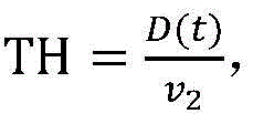
选定两前后关系的目标,从全局信息集合Wtotal中提取两者的单元并分别进行1)所述的数据处理,得到两者的位置信息序列l1、l2以及速度信息序列v1、v2。根据l1、l2对应时刻数据计算欧式距离,可以得到两者的前后间隔即车辆跟驰距离序列D(t),通过设定阈值,可以判断后者在行驶过程中是否发生跟驰过近行为;根据MOR公式

3)两并排关系的并排行驶参数。3) Side-by-side driving parameters of two side-by-side relationships.
选定两并排关系的目标,从全局信息集合Wtotal中提取两者的单元并分别进行1)所述的数据处理,得到两者的位置信息序列l1、l2,根据l1、l2对应时刻数据计算欧式距离,可以得到两者的并排间隔序列D(h),通过设定阈值,可以判断两者在行驶过程中是否发生不良并行行为。Select two targets in a side-by-side relationship, extract the two units from the global information set W total , and perform the data processing described in 1) respectively to obtain the two position information sequences l 1 , l 2 , according to l 1 , l 2 The Euclidean distance is calculated according to the data at the time, and the side-by-side interval sequence D(h) of the two can be obtained. By setting the threshold, it can be judged whether the two have bad parallel behavior during the driving process.
结合实例说明,如附图3所示,在跨摄像头匹配模块中,系统赋予目标A车辆的ID为11,目标B车辆的ID为13。附图3中记录了该时刻两者的速度、当前车道、单位时间变道次数、两车跟驰距离D、后车车头时距TH和碰撞时间TTC。(由于两车呈前后状态,故没有计算并排行驶参数)。With reference to an example, as shown in FIG. 3 , in the cross-camera matching module, the system assigns the ID of the target A vehicle as 11, and the ID of the target B vehicle as 13. Figure 3 records the speed of the two vehicles at this moment, the current lane, the number of lane changes per unit time, the following distance D of the two vehicles, the headway TH of the rear vehicle, and the collision time TTC. (Because the two vehicles are in a front-to-back state, the side-by-side driving parameters are not calculated).
Claims (3)


Priority Applications (1)
| Application Number | Priority Date | Filing Date | Title |
|---|---|---|---|
| CN201911360542.9A CN111145545B (en) | 2019-12-25 | 2019-12-25 | UAV monitoring system and method for road traffic behavior based on deep learning |
Applications Claiming Priority (1)
| Application Number | Priority Date | Filing Date | Title |
|---|---|---|---|
| CN201911360542.9A CN111145545B (en) | 2019-12-25 | 2019-12-25 | UAV monitoring system and method for road traffic behavior based on deep learning |
Publications (2)
| Publication Number | Publication Date |
|---|---|
| CN111145545A CN111145545A (en) | 2020-05-12 |
| CN111145545B true CN111145545B (en) | 2021-05-28 |
Family
ID=70520178
Family Applications (1)
| Application Number | Title | Priority Date | Filing Date |
|---|---|---|---|
| CN201911360542.9A Active CN111145545B (en) | 2019-12-25 | 2019-12-25 | UAV monitoring system and method for road traffic behavior based on deep learning |
Country Status (1)
| Country | Link |
|---|---|
| CN (1) | CN111145545B (en) |
Cited By (1)
| Publication number | Priority date | Publication date | Assignee | Title |
|---|---|---|---|---|
| US11765562B2 (en) | 2021-10-11 | 2023-09-19 | Toyota Motor Engineering & Manufacturing North America, Inc. | Systems and methods for matching objects in collaborative perception messages |
Families Citing this family (60)
| Publication number | Priority date | Publication date | Assignee | Title |
|---|---|---|---|---|
| CN111833598B (en) * | 2020-05-14 | 2022-07-05 | 山东科技大学 | A method and system for automatic monitoring of highway UAV traffic incidents |
| CN111627220B (en) * | 2020-05-22 | 2021-03-23 | 中国科学院空天信息创新研究院 | A UAV and Ground Co-processing System for Vehicle Detection |
| CN111554105B (en) * | 2020-05-29 | 2021-08-03 | 浙江科技学院 | An intelligent flow recognition and statistics method for complex traffic intersections |
| CN113766179B (en) * | 2020-06-05 | 2024-12-13 | 上海竺程信息科技有限公司 | A camera-based intelligent roadside system |
| CN111696138B (en) * | 2020-06-17 | 2023-06-30 | 北京大学深圳研究生院 | A system for automatically collecting, tracking and analyzing biological behavior |
| CN111898436A (en) * | 2020-06-29 | 2020-11-06 | 北京大学 | Multi-target tracking processing optimization method based on visual signals |
| CN111724603B (en) * | 2020-07-01 | 2021-05-18 | 中南大学 | CAV state determination method, device, device and medium based on traffic trajectory data |
| CN113963019A (en) * | 2020-07-03 | 2022-01-21 | 阿里巴巴集团控股有限公司 | Target tracking method, computing device and storage medium |
| CN111968367B (en) * | 2020-08-12 | 2021-12-14 | 上海宝通汎球电子有限公司 | Internet of things communication management system and management method |
| CN111784747B (en) * | 2020-08-13 | 2024-02-27 | 青岛高重信息科技有限公司 | Multi-target vehicle tracking system and method based on key point detection and correction |
| TWI777223B (en) * | 2020-08-21 | 2022-09-11 | 交通部運輸研究所 | Unmanned aerial vehicle traffic survey system and method thereof |
| CN112102372A (en) * | 2020-09-16 | 2020-12-18 | 上海麦图信息科技有限公司 | Cross-camera track tracking system for airport ground object |
| CN112183528B (en) * | 2020-09-23 | 2022-06-21 | 桂林电子科技大学 | Method for tracking target vehicle, device, system and computer storage medium thereof |
| CN112184814B (en) * | 2020-09-24 | 2022-09-02 | 天津锋物科技有限公司 | Positioning method and positioning system |
| CN112149595A (en) * | 2020-09-29 | 2020-12-29 | 爱动超越人工智能科技(北京)有限责任公司 | Method for detecting lane line and vehicle violation by using unmanned aerial vehicle |
| CN112381982B (en) * | 2020-10-19 | 2022-02-22 | 北京科技大学 | Unmanned supermarket system constructed based on deep learning |
| CN112381022B (en) * | 2020-11-20 | 2021-05-18 | 深圳市汇芯视讯电子有限公司 | A kind of intelligent driving monitoring method, system, equipment and storable medium |
| CN112212881B (en) * | 2020-12-14 | 2021-03-12 | 成都飞航智云科技有限公司 | A flight navigator based on Beidou application |
| CN112735164B (en) * | 2020-12-25 | 2022-08-05 | 北京智能车联产业创新中心有限公司 | Test data construction method and test method |
| CN112836683B (en) * | 2021-03-04 | 2024-07-09 | 广东建邦计算机软件股份有限公司 | License plate recognition method, device, equipment and medium for portable camera device |
| CN112699854B (en) * | 2021-03-22 | 2021-07-20 | 亮风台(上海)信息科技有限公司 | Method and device for identifying stopped vehicle |
| CN113421289B (en) * | 2021-05-17 | 2022-09-20 | 同济大学 | High-precision vehicle track data extraction method for overcoming unmanned aerial vehicle shooting disturbance |
| CN113269424B (en) * | 2021-05-17 | 2023-06-09 | 西安交通大学 | Robot cluster task allocation method, system, equipment and storage medium |
| CN115409874B (en) * | 2021-05-27 | 2026-01-16 | 中国移动通信有限公司研究院 | Vehicle matching method and device and electronic equipment |
| CN113569647B (en) * | 2021-06-29 | 2024-02-20 | 广州赋安数字科技有限公司 | AIS-based ship high-precision coordinate mapping method |
| CN113469069A (en) * | 2021-07-06 | 2021-10-01 | 沈阳工业大学 | Method for acquiring and evaluating parameters of vehicle running congestion state of highway section |
| CN113469117A (en) * | 2021-07-20 | 2021-10-01 | 国网信息通信产业集团有限公司 | Multi-channel video real-time detection method and system |
| CN113674329A (en) * | 2021-08-13 | 2021-11-19 | 上海同温层智能科技有限公司 | Vehicle driving behavior detection method and system |
| CN113763425B (en) * | 2021-08-30 | 2024-12-10 | 青岛海信网络科技股份有限公司 | Road area calibration method and electronic equipment |
| CN113850863B (en) * | 2021-08-31 | 2025-08-19 | 华人运通(上海)自动驾驶科技有限公司 | Method, equipment and positioning system for positioning vehicle by utilizing road end acquisition equipment |
| CN113792634B (en) * | 2021-09-07 | 2022-04-15 | 北京易航远智科技有限公司 | Target similarity score calculation method and system based on vehicle-mounted camera |
| CN114038193B (en) * | 2021-11-08 | 2023-07-18 | 华东师范大学 | Intelligent traffic flow data statistics method and system based on UAV and multi-target tracking |
| CN114155511B (en) * | 2021-12-13 | 2024-11-26 | 吉林大学 | A method for collecting environmental information for autonomous vehicles on public roads |
| CN114549593B (en) * | 2022-02-25 | 2022-11-29 | 北京拙河科技有限公司 | Target tracking method and system for multiple targets and multiple cameras |
| CN114550539B (en) * | 2022-03-08 | 2023-11-21 | 北京迈瑞思智能科技有限公司 | Method for recording animation trace of training track of training vehicle in driving school |
| CN114926789A (en) * | 2022-04-13 | 2022-08-19 | 西安卓越视讯科技有限公司 | Real-time traffic data acquisition method, system, equipment and storage medium for highway |
| CN114783181B (en) * | 2022-04-13 | 2023-04-28 | 江苏集萃清联智控科技有限公司 | Traffic flow statistics method and device based on road side perception |
| CN114818981A (en) * | 2022-05-27 | 2022-07-29 | 上海交通大学宁波人工智能研究院 | Imitation learning method for driving behaviors |
| CN115205334B (en) * | 2022-06-29 | 2026-01-06 | 同济大学 | A method for constructing global vehicle trajectories using incomplete sensing data |
| CN115457780B (en) * | 2022-09-06 | 2024-06-14 | 北京航空航天大学 | A method and system for automatically calculating vehicle flow velocity based on a priori knowledge set |
| CN115690745A (en) * | 2022-11-14 | 2023-02-03 | 浙江大学宁波“五位一体”校区教育发展中心 | A method, system and device for fully automatic vehicle speed measurement based on unmanned aerial vehicle monocular vision |
| CN116069976B (en) * | 2023-03-06 | 2023-09-12 | 南京和电科技有限公司 | Regional video analysis method and system |
| CN116229298B (en) * | 2023-03-13 | 2025-12-26 | 吉林大学 | A method for extracting key test scenarios for intelligent vehicles based on aerial photography datasets |
| CN116342651A (en) * | 2023-03-17 | 2023-06-27 | 无锡市神韵科技发展有限公司 | An artificial intelligence-based intelligent detection system and method for driving safety |
| CN117456723B (en) * | 2023-09-26 | 2024-06-07 | 长春理工大学 | Automatic driving vehicle motion trail analysis system of intelligent traffic system |
| CN117237418B (en) * | 2023-11-15 | 2024-01-23 | 成都航空职业技术学院 | Moving object detection method and system based on deep learning |
| CN118015050B (en) * | 2023-11-29 | 2026-01-02 | 爱泊车科技有限公司 | A Method and System for Multi-Camera Video Joint Analysis for Vehicle Tracking |
| CN117649432B (en) * | 2023-12-04 | 2024-08-20 | 成都臻识科技发展有限公司 | Cross-camera multi-target tracking method, device and readable storage medium |
| CN117593717B (en) * | 2024-01-18 | 2024-04-05 | 武汉大学 | Lane tracking method and system based on deep learning |
| CN117636270B (en) * | 2024-01-23 | 2024-04-09 | 南京理工大学 | Vehicle robbery event identification method and device based on monocular camera |
| CN118015499B (en) * | 2024-03-19 | 2025-03-25 | 合肥工业大学 | A road longitudinal slope estimation method based on drone aerial video |
| CN118015844B (en) * | 2024-04-10 | 2024-06-11 | 成都航空职业技术学院 | A traffic dynamic control method and system based on deep learning network |
| CN118865227B (en) * | 2024-06-18 | 2025-11-25 | 厦门远海集装箱码头有限公司 | A Visual Analysis-Based Automatic Transition Method and System for RTG |
| CN118470652B (en) * | 2024-07-11 | 2024-09-17 | 深圳市城市交通规划设计研究中心股份有限公司 | Unmanned aerial vehicle illegal intrusion detection system, unmanned aerial vehicle illegal intrusion detection method and computer equipment |
| CN118486100B (en) * | 2024-07-15 | 2024-11-19 | 合众新能源汽车股份有限公司 | Driving data processing method, prediction method, system, device and medium |
| CN118506298B (en) * | 2024-07-17 | 2024-09-20 | 江西锦路科技开发有限公司 | Cross-camera vehicle track association method |
| CN119206586B (en) * | 2024-11-26 | 2025-04-04 | 杭州海康威视数字技术股份有限公司 | Target analysis method and electronic equipment |
| CN119252039A (en) * | 2024-12-05 | 2025-01-03 | 上海聪链信息科技有限公司 | Park vehicle real-time tracking system |
| CN119788819A (en) * | 2025-01-02 | 2025-04-08 | 中国铁塔股份有限公司中山市分公司 | A target linkage tracking system and method based on unmanned aerial vehicle and high-position ball camera video |
| CN120014542B (en) * | 2025-01-10 | 2025-10-14 | 南京市地铁交通设施保护办公室 | Image processing method and system for subway line protection area |
Family Cites Families (15)
| Publication number | Priority date | Publication date | Assignee | Title |
|---|---|---|---|---|
| CN101075376B (en) * | 2006-05-19 | 2010-11-03 | 无锡易斯科电子技术有限公司 | Intelligent video traffic monitoring system based on multi-viewpoints and its method |
| CN102510482A (en) * | 2011-11-29 | 2012-06-20 | 蔡棽 | Image splicing reconstruction and overall monitoring method for improving visibility and visual distance |
| CN102915638A (en) * | 2012-10-07 | 2013-02-06 | 复旦大学 | Surveillance video-based intelligent parking lot management system |
| CN103281519A (en) * | 2013-05-30 | 2013-09-04 | 水木路拓科技(北京)有限公司 | Novel road traffic surveillance camera system |
| US9396660B2 (en) * | 2014-01-21 | 2016-07-19 | Speedgauge, Inc. | Identification of driver abnormalities in a traffic flow |
| JP2016119547A (en) * | 2014-12-19 | 2016-06-30 | トヨタ自動車株式会社 | Remote collection system for vehicle data |
| CN105407278A (en) * | 2015-11-10 | 2016-03-16 | 北京天睿空间科技股份有限公司 | Panoramic video traffic situation monitoring system and method |
| US10241651B2 (en) * | 2016-12-22 | 2019-03-26 | Sap Se | Grid-based rendering of nodes and relationships between nodes |
| CN107067706A (en) * | 2017-03-05 | 2017-08-18 | 赵莉莉 | Command the traffic supervision system for vehicles of managing and control system in real time comprehensively based on intelligent transportation |
| CN108734655B (en) * | 2017-04-14 | 2021-11-30 | 中国科学院苏州纳米技术与纳米仿生研究所 | Method and system for detecting multiple nodes in air in real time |
| KR101845943B1 (en) * | 2017-07-26 | 2018-04-05 | 주식회사 한일에스티엠 | A system and method for recognizing number plates on multi-lane using one camera |
| CN107886761A (en) * | 2017-11-14 | 2018-04-06 | 金陵科技学院 | A kind of parking lot monitoring method based on unmanned plane |
| CN107967817A (en) * | 2017-11-17 | 2018-04-27 | 张慧 | Intelligent managing system for parking lot and method based on multi-path camera deep learning |
| CN109034446A (en) * | 2018-06-13 | 2018-12-18 | 南京理工大学 | The smart city traffic incident emergency response system collected evidence online based on unmanned plane |
| CN110472496B (en) * | 2019-07-08 | 2022-10-11 | 长安大学 | Traffic video intelligent analysis method based on target detection and tracking |
-
2019
- 2019-12-25 CN CN201911360542.9A patent/CN111145545B/en active Active
Cited By (1)
| Publication number | Priority date | Publication date | Assignee | Title |
|---|---|---|---|---|
| US11765562B2 (en) | 2021-10-11 | 2023-09-19 | Toyota Motor Engineering & Manufacturing North America, Inc. | Systems and methods for matching objects in collaborative perception messages |
Also Published As
| Publication number | Publication date |
|---|---|
| CN111145545A (en) | 2020-05-12 |
Similar Documents
| Publication | Publication Date | Title |
|---|---|---|
| CN111145545B (en) | UAV monitoring system and method for road traffic behavior based on deep learning | |
| CN114023062B (en) | Traffic flow information monitoring method based on deep learning and edge calculation | |
| CN112101433B (en) | An automatic lane-dividing vehicle counting method based on YOLO V4 and DeepSORT | |
| Akbari et al. | Applications, databases and open computer vision research from drone videos and images: a survey | |
| CN114170580B (en) | A method for detecting abnormal events on highways | |
| CN102436738B (en) | A drone-based traffic monitoring device | |
| US12148219B2 (en) | Method, apparatus, and computing device for lane recognition | |
| CN111967313B (en) | Unmanned aerial vehicle image annotation method assisted by deep learning target detection algorithm | |
| CN112836683B (en) | License plate recognition method, device, equipment and medium for portable camera device | |
| CN114372503B (en) | A method for predicting the motion trajectory of cluster vehicles | |
| KR20200071799A (en) | object recognition and counting method using deep learning artificial intelligence technology | |
| KR20210140766A (en) | Digital reconstruction methods, devices and systems for traffic roads | |
| CN110619276A (en) | Anomaly and violence detection system and method based on unmanned aerial vehicle mobile monitoring | |
| Meng et al. | Video‐Based Vehicle Counting for Expressway: A Novel Approach Based on Vehicle Detection and Correlation‐Matched Tracking Using Image Data from PTZ Cameras | |
| Chang et al. | Video analytics in smart transportation for the AIC'18 challenge | |
| CN117994987B (en) | Traffic parameter extraction method and related device based on target detection technology | |
| Jiao et al. | Traffic behavior recognition from traffic videos under occlusion condition: a Kalman filter approach | |
| CN107067813A (en) | A kind of parking stall bootstrap technique and system based on image procossing and pattern-recognition | |
| CN111627224A (en) | Vehicle speed abnormality detection method, device, equipment and storage medium | |
| CN114821364B (en) | A DeepSort garden waste statistics method based on drone motion status | |
| CN117911965B (en) | Expressway traffic accident identification method and equipment based on aerial image | |
| CN112465854A (en) | Unmanned aerial vehicle tracking method based on anchor-free detection algorithm | |
| CN120452196A (en) | A vehicle identification and traffic incident detection method and system based on drone perspective | |
| Lv et al. | The UAV benchmark: Compact detection of vehicles in urban scenarios | |
| Notz et al. | Extraction and assessment of naturalistic human driving trajectories from infrastructure camera and radar sensors |
Legal Events
| Date | Code | Title | Description |
|---|---|---|---|
| PB01 | Publication | ||
| PB01 | Publication | ||
| SE01 | Entry into force of request for substantive examination | ||
| SE01 | Entry into force of request for substantive examination | ||
| GR01 | Patent grant | ||
| GR01 | Patent grant |