CN110298348B - Remote sensing image building sample area extraction method and system, storage medium and equipment - Google Patents
Remote sensing image building sample area extraction method and system, storage medium and equipment Download PDFInfo
- Publication number
- CN110298348B CN110298348B CN201910506618.8A CN201910506618A CN110298348B CN 110298348 B CN110298348 B CN 110298348B CN 201910506618 A CN201910506618 A CN 201910506618A CN 110298348 B CN110298348 B CN 110298348B
- Authority
- CN
- China
- Prior art keywords
- building
- sample
- remote sensing
- data
- area
- Prior art date
- Legal status (The legal status is an assumption and is not a legal conclusion. Google has not performed a legal analysis and makes no representation as to the accuracy of the status listed.)
- Active
Links
Images



Classifications
-
- G—PHYSICS
- G06—COMPUTING OR CALCULATING; COUNTING
- G06F—ELECTRIC DIGITAL DATA PROCESSING
- G06F18/00—Pattern recognition
- G06F18/20—Analysing
- G06F18/21—Design or setup of recognition systems or techniques; Extraction of features in feature space; Blind source separation
- G06F18/214—Generating training patterns; Bootstrap methods, e.g. bagging or boosting
-
- G—PHYSICS
- G06—COMPUTING OR CALCULATING; COUNTING
- G06N—COMPUTING ARRANGEMENTS BASED ON SPECIFIC COMPUTATIONAL MODELS
- G06N3/00—Computing arrangements based on biological models
- G06N3/02—Neural networks
- G06N3/04—Architecture, e.g. interconnection topology
- G06N3/045—Combinations of networks
-
- G—PHYSICS
- G06—COMPUTING OR CALCULATING; COUNTING
- G06V—IMAGE OR VIDEO RECOGNITION OR UNDERSTANDING
- G06V10/00—Arrangements for image or video recognition or understanding
- G06V10/20—Image preprocessing
- G06V10/26—Segmentation of patterns in the image field; Cutting or merging of image elements to establish the pattern region, e.g. clustering-based techniques; Detection of occlusion
- G06V10/267—Segmentation of patterns in the image field; Cutting or merging of image elements to establish the pattern region, e.g. clustering-based techniques; Detection of occlusion by performing operations on regions, e.g. growing, shrinking or watersheds
Landscapes
- Engineering & Computer Science (AREA)
- Theoretical Computer Science (AREA)
- Physics & Mathematics (AREA)
- Data Mining & Analysis (AREA)
- General Physics & Mathematics (AREA)
- Life Sciences & Earth Sciences (AREA)
- Artificial Intelligence (AREA)
- General Engineering & Computer Science (AREA)
- Evolutionary Computation (AREA)
- Computer Vision & Pattern Recognition (AREA)
- Computational Linguistics (AREA)
- Bioinformatics & Computational Biology (AREA)
- Bioinformatics & Cheminformatics (AREA)
- Health & Medical Sciences (AREA)
- Biomedical Technology (AREA)
- Biophysics (AREA)
- Evolutionary Biology (AREA)
- General Health & Medical Sciences (AREA)
- Molecular Biology (AREA)
- Computing Systems (AREA)
- Mathematical Physics (AREA)
- Software Systems (AREA)
- Multimedia (AREA)
- Image Analysis (AREA)
Abstract
Description
技术领域technical field
本发明涉及高空间分辨率遥感影像信息提取领域,尤其涉及遥感影像建筑物样本区域提取方法。The invention relates to the field of high spatial resolution remote sensing image information extraction, in particular to a method for extracting building sample regions from remote sensing images.
背景技术Background technique
从高空间分辨率影像中提取建筑屋顶的方法,已从基于像素的多尺度分割技术、基于面向对象的分类技术,发展为目前较为有效的基于深度卷积网络的语义分割技术,较为流行的网络有FCN、PSPNet、Mask-RCNN、D-LinkNet等。然而,与无监督的多尺度分割技术相比,虽然其分割效果具有明显优势,但需要标注大量的样本来用于训练深度卷积网络的参数,这是由于不同类型遥感影像间存在空间分辨率、影像波段数、波段通道存储位数的差异,且同一类地物表现出的特征差异较大。面对一个区域(如县域)的制作任务选择样本区域时,目前的方法是对目标区域进行人工目视判别,随机或凭经验选取若干样本区域,进行裁切、标注,在训练、提取后,再对效果不好区域重复人工判别等步骤,直到提取效果符合最终精度。这样会有极大的不确定性,所选的样本也容易存在特征表征的重复,造成重复标注相同类型样本的浪费,降低了制作效率。The method of extracting building roofs from high spatial resolution images has developed from pixel-based multi-scale segmentation technology and object-oriented classification technology to more effective semantic segmentation technology based on deep convolutional networks. There are FCN, PSPNet, Mask-RCNN, D-LinkNet, etc. However, compared with unsupervised multi-scale segmentation techniques, although its segmentation effect has obvious advantages, it needs to label a large number of samples for training parameters of deep convolutional networks, which is due to the existence of spatial resolution between different types of remote sensing images. , the number of image bands, and the number of storage bits of the band channel, and the features of the same type of objects are quite different. When selecting a sample area for the production task of an area (such as a county), the current method is to perform manual visual discrimination on the target area, randomly or empirically select several sample areas, cut and label, and after training and extraction, Repeat steps such as manual discrimination for the areas with poor effect until the extraction effect meets the final accuracy. In this way, there will be great uncertainty, and the selected samples are also prone to duplication of feature representations, resulting in the waste of repeatedly labeling the same type of samples and reducing the production efficiency.
发明内容SUMMARY OF THE INVENTION
为了克服现有技术的不足,本发明提供遥感影像建筑物样本区域提取方法。本发明通过基于深度学习的卷积计算快速计算得到有效且具有代表性的样本区域,减少了人工标注的工作量。In order to overcome the deficiencies of the prior art, the present invention provides a method for extracting building sample regions from remote sensing images. The present invention obtains effective and representative sample regions through rapid calculation based on deep learning-based convolution calculation, and reduces the workload of manual labeling.
本发明提供遥感影像建筑物样本区域提取方法,包括如下步骤:The present invention provides a method for extracting a sample area of a building from a remote sensing image, comprising the following steps:
S1、样本制作,采集遥感影像,对目标区域的所述遥感影像进行分割裁剪得到包括分类对象的面矢量框文件,并标注所述面矢量文件中的带建筑物标签,将标签为带建筑物的所述面矢量样本的矢量数据转换成栅格数据,得到栅格化的建筑物样本;若干个带有建筑物标签的样本构成样本集,并将所述面矢量框文件加入所述样本集;其中所述建筑物样本的尺寸包括长为X像素,宽为Y像素;S1, sample making, collecting remote sensing images, segmenting and cutting the remote sensing images of the target area to obtain a surface vector frame file including a classification object, and marking the label with buildings in the surface vector file, and labeling the label as with buildings The vector data of the surface vector samples are converted into raster data to obtain rasterized building samples; several samples with building labels constitute a sample set, and the surface vector frame file is added to the sample set ; wherein the size of the building sample includes a length of X pixels and a width of Y pixels;
S2、建筑物预测,将待测试的遥感影像数据输入利用当前所述样本集训练好的建筑物模型并对所述目标区域的遥感影像进行预测,得到遥感影像中栅格化的建筑物数据;所述建筑物数据中的每个栅格的取值范围为第一阈值范围,其中最大值代表最高概率属于建筑,最小值代表最高概率属于非建筑;S2, building prediction, input the remote sensing image data to be tested into a building model trained using the current sample set and predict the remote sensing image of the target area to obtain rasterized building data in the remote sensing image; The value range of each grid in the building data is the first threshold range, wherein the maximum value represents that the highest probability belongs to a building, and the minimum value represents that the highest probability belongs to a non-building;
S4、卷积计算,利用与所述建筑物样本尺寸相同的矩阵窗口对所述建筑物数据进行全卷积相乘,当矩阵窗口与其对应的所述建筑强度影像区域的卷积相乘结果大于阈值E时,将当前所述矩阵窗口所对应的所述面矢量框文件进行标记并放入样本待选区域列表;所述矩阵窗口的每个栅格的取值均为P;S4, convolution calculation, use the matrix window with the same size as the building sample to perform full convolution multiplication on the building data, when the matrix window and the corresponding convolution multiplication result of the building intensity image area are greater than When the threshold value is E, the surface vector frame file corresponding to the current matrix window is marked and placed in the list of sample regions to be selected; the value of each grid of the matrix window is P;
所述阈值E的计算公式如下:The calculation formula of the threshold E is as follows:
E=10·X·Y·max[1,(10-t-1)]/P,E=10·X·Y·max[1,(10-t-1)]/P,
其中,t为所述矩阵窗口在所述建筑物数据上移动的次数;Wherein, t is the number of times the matrix window moves on the building data;
S5、精度评定,从所述样本待选区域列表中选择n个所述面矢量框文件进行样本标注;S5. Accuracy evaluation, selecting n of the surface vector frame files from the sample candidate area list for sample labeling;
当n大于0时,从所述样本待选区域列表中选择所述卷积相乘的结果最小的[n/2]个区域和所述卷积相乘的结果最大的n-[n/2]个区域返回步骤S1修改样本重新迭代训练;其中“[]”为取整符号;当n等于0时,进入下个步骤;When n is greater than 0, select [n/2] areas with the smallest result of the convolution multiplication and n-[n/2 areas with the largest result of the convolution multiplication from the sample candidate area list ] areas return to step S1 to modify the samples and re-iteratively train; wherein "[]" is the rounding symbol; when n is equal to 0, enter the next step;
S6、结果矢量化,将当前的所述建筑物数据进行二值化并进行矢量化得到标记样本区域的遥感影像建筑物数据。S6. The result is vectorized, and the current building data is binarized and vectorized to obtain remote sensing image building data of the marked sample area.
优选地,在步骤S2与步骤S4中还包括步骤:Preferably, step S2 and step S4 also include steps:
S3、优化数据,将所述建筑物数据的每个栅格的取值范围位于第二阈值范围内的进行保留,同时将所述建筑物数据的其他取值的栅格全部标记为0,所述第二阈值范围位于所述第一阈值范围之间,得到优化的建筑物数据。S3, optimize the data, retain the value range of each grid of the building data within the second threshold range, and at the same time mark all grids with other values of the building data as 0, so The second threshold range is located between the first threshold ranges to obtain optimized building data.
优选地,在步骤S1中还包括:所述目标区域所需标注的样本数量的最大值为M,M的计算公式为:Preferably, step S1 also includes: the maximum value of the number of samples to be marked in the target area is M, and the calculation formula of M is:
M=S/50M=S/50
其中,S为所述目标区域的总面积(单位为平方公里);Wherein, S is the total area of the target area (unit is square kilometers);
所述目标区域当前的样本数量记为m;The current number of samples in the target area is denoted as m;
在步骤S5中,n的计算公式如下:In step S5, the calculation formula of n is as follows:
n=max[N,(M-m)/2]n=max[N,(M-m)/2]
其中,N为步骤S4中的所述样本待选区域列表的样本数量。Wherein, N is the number of samples in the sample candidate region list in step S4.
优选地,在步骤S2中,所述第一阈值范围包括0-255,255代表最高概率属于建筑,0代表最高概率属于非建筑;在步骤S3中第二阈值范围包括50-150。Preferably, in step S2, the first threshold range includes 0-255, 255 represents that the highest probability belongs to buildings, and 0 represents that the highest probability belongs to non-buildings; in step S3, the second threshold range includes 50-150.
优选地,在步骤S6中,进行二值化后的所述建筑物数据的阈值范围为30-70。Preferably, in step S6, the threshold range of the binarized building data is 30-70.
优选地,所述建筑物模型包括初始模型,所述初始模型的训练方法包括:Preferably, the building model includes an initial model, and the training method of the initial model includes:
对目标区域的所述遥感影像进行分割裁剪得到若干个长为X像素,宽为Y像素的带建筑物标签的样本,利用D-LinkNet网络进行训练学习得到所述初始模型;所述初始模型还包括选取与所述建筑物样本分辨率相同的并训练学习好的网络参数文件。The remote sensing image of the target area is segmented and cropped to obtain a number of samples with building labels that are X pixels long and Y pixels wide, and the D-LinkNet network is used for training and learning to obtain the initial model; the initial model is also It includes selecting a network parameter file with the same resolution as the building sample and trained and learned.
一种电子设备,包括:处理器;An electronic device, comprising: a processor;
存储器;以及程序,其中所述程序被存储在所述存储器中,并且被配置成由处理器执行,所述程序包括用于执行遥感影像建筑物样本区域提取方法。a memory; and a program, wherein the program is stored in the memory and configured to be executed by a processor, the program including a method for performing a remote sensing image building sample area extraction method.
一种计算机可读存储介质,其上存储有计算机程序,所述计算机程序被处理器执行遥感影像建筑物样本区域提取方法。A computer-readable storage medium on which a computer program is stored, the computer program being executed by a processor to extract a sample area of a building from a remote sensing image.
遥感影像建筑物样本区域提取系统,包括:样本制作模块、建筑物预测模块、卷积计算模块、精度评定模块和结果矢量化模块;其中,A remote sensing image building sample area extraction system, including: a sample production module, a building prediction module, a convolution calculation module, an accuracy assessment module and a result vectorization module; wherein,
所述样本制作模块用于采集遥感影像,对目标区域的所述遥感影像进行分割裁剪得到包括分类对象的面矢量框文件,并标注所述面矢量文件中的带建筑物标签,将标签为带建筑物的所述面矢量样本的矢量数据转换成栅格数据,得到栅格化的建筑物样本;若干个带有建筑物标签的样本构成样本集,并将所述面矢量框文件加入所述样本集;其中所述建筑物样本的尺寸包括长为X像素,宽为Y像素;The sample making module is used to collect remote sensing images, segment and cut the remote sensing images of the target area to obtain a surface vector frame file including classified objects, and mark the label with buildings in the surface vector file, and label the label as a band. The vector data of the surface vector samples of the building is converted into raster data to obtain rasterized building samples; several samples with building labels form a sample set, and the surface vector frame file is added to the A sample set; wherein the size of the building sample includes a length of X pixels and a width of Y pixels;
所述建筑物预测模块用于将待测试的遥感影像数据输入利用当前所述样本集训练好的建筑物模型并对所述目标区域的遥感影像进行预测,得到遥感影像中栅格化的建筑物数据;所述建筑物数据中的每个栅格的取值范围为第一阈值范围,其中最大值代表最高概率属于建筑,最小值代表最高概率属于非建筑;The building prediction module is used to input the remote sensing image data to be tested into a building model trained by using the current sample set and predict the remote sensing image of the target area, so as to obtain the rasterized building in the remote sensing image. data; the value range of each grid in the building data is the first threshold range, where the maximum value represents that the highest probability belongs to a building, and the minimum value represents that the highest probability belongs to a non-building;
所述卷积计算模块用于利用与所述建筑物样本尺寸相同的矩阵窗口对所述建筑物数据进行全卷积相乘,当矩阵窗口与其对应的所述建筑强度影像区域的卷积相乘结果大于阈值E时,将当前所述矩阵窗口所对应的所述面矢量框文件进行标记并放入样本待选区域列表;所述矩阵窗口的每个栅格的取值均为P;The convolution calculation module is used to perform full convolution multiplication on the building data by using a matrix window with the same size as the building sample, when the matrix window is multiplied by the convolution of the corresponding building intensity image area. When the result is greater than the threshold value E, mark the surface vector box file corresponding to the current matrix window and put it into the list of sample regions to be selected; the value of each grid of the matrix window is P;
所述阈值E的计算公式如下:The calculation formula of the threshold E is as follows:
E=10·X·Y·max[1,(10-t-1)]/P,E=10·X·Y·max[1,(10-t-1)]/P,
其中,t为所述矩阵窗口在所述建筑物数据上移动的次数;Wherein, t is the number of times the matrix window moves on the building data;
所述精度评定模块用于从所述样本待选区域列表中选择n个所述面矢量框文件进行样本标注;The accuracy evaluation module is configured to select n of the surface vector frame files from the sample candidate area list for sample labeling;
当n大于0时,从所述样本待选区域列表中选择所述卷积相乘的结果最小的[n/2]个区域和所述卷积相乘的结果最大的n-[n/2]个区域返回步骤S1修改样本重新迭代训练;其中“[]”为取整符号;当n等于0时,进入下个步骤;When n is greater than 0, select [n/2] areas with the smallest result of the convolution multiplication and n-[n/2 areas with the largest result of the convolution multiplication from the sample candidate area list ] areas return to step S1 to modify the samples and re-iteratively train; wherein "[]" is the rounding symbol; when n is equal to 0, enter the next step;
所述结果矢量化模块用于将当前的所述建筑物数据进行二值化并进行矢量化得到标记样本区域的遥感影像建筑物数据。The result vectorization module is used for binarizing and vectorizing the current building data to obtain remote sensing image building data of the marked sample area.
优选地,还包括优化数据模块,所述优化数据模块用于将所述建筑物数据的每个栅格的取值范围位于第二阈值范围内的进行保留,同时将所述建筑物数据的其他取值的栅格全部标记为0,所述第二阈值范围位于所述第一阈值范围之间,得到优化的建筑物数据;Preferably, an optimization data module is also included, and the optimization data module is configured to retain the value range of each grid of the building data within the second threshold range, and at the same time store other data of the building data. The grids of values are all marked as 0, and the second threshold range is located between the first threshold ranges to obtain optimized building data;
所述卷积计算模块包括计算单元,所述计算单元用于计算所述目标区域所需标注的样本数量的最大值为M,M的计算公式为:The convolution calculation module includes a calculation unit, and the calculation unit is used to calculate the maximum value of the number of samples to be marked in the target area, and the calculation formula of M is:
M=S/50M=S/50
其中,S为所述目标区域的总面积(单位为平方公里);Wherein, S is the total area of the target area (unit is square kilometers);
所述目标区域当前的样本数量记为m;The current number of samples in the target area is denoted as m;
在步骤S5中,n的计算公式如下:In step S5, the calculation formula of n is as follows:
n=max[N,(M-m)/2]n=max[N,(M-m)/2]
其中,N为步骤S4中的所述样本待选区域列表的样本数量。Wherein, N is the number of samples in the sample candidate region list in step S4.
相比现有技术,本发明的有益效果在于:Compared with the prior art, the beneficial effects of the present invention are:
本发明通过基于深度学习的卷积计算快速计算得到有效且具有代表性的样本区域,增强了典型样本区域选择的自动化程度和有效性,从而减少了任务所需样本的数量同时也减少了人工标注的工作量。The present invention obtains effective and representative sample regions through rapid calculation based on convolution calculation based on deep learning, which enhances the automation degree and effectiveness of typical sample region selection, thereby reducing the number of samples required for tasks and reducing manual labeling. workload.
上述说明仅是本发明技术方案的概述,为了能够更清楚了解本发明的技术手段,并可依照说明书的内容予以实施,以下以本发明的较佳实施例并配合附图详细说明如后。本发明的具体实施方式由以下实施例及其附图详细给出。The above description is only an overview of the technical solution of the present invention. In order to understand the technical means of the present invention more clearly, and implement it according to the content of the description, the preferred embodiments of the present invention are described in detail below with the accompanying drawings. Specific embodiments of the present invention are given in detail by the following examples and the accompanying drawings.
附图说明Description of drawings
此处所说明的附图用来提供对本发明的进一步理解,构成本申请的一部分,本发明的示意性实施例及其说明用于解释本发明,并不构成对本发明的不当限定。在附图中:The accompanying drawings described herein are used to provide a further understanding of the present invention and constitute a part of the present application. The exemplary embodiments of the present invention and their descriptions are used to explain the present invention and do not constitute an improper limitation of the present invention. In the attached image:
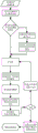
图1为本发明的遥感影像建筑物样本区域提取方法的整体流程示意图;1 is a schematic diagram of the overall flow of a method for extracting a building sample area from a remote sensing image of the present invention;
图2为本发明的遥感影像建筑物样本区域提取方法的整体逻辑示意图;Fig. 2 is the overall logical schematic diagram of the remote sensing image building sample area extraction method of the present invention;
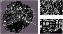
图3为本发明的遥感影像建筑物样本区域提取方法的矩阵窗口对建筑物数据进行第二次卷积后得出的建筑物数据图;3 is a building data diagram obtained after the matrix window of the remote sensing image building sample area extraction method of the present invention performs the second convolution on building data;
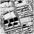
图4a为本发明的遥感影像建筑物样本区域提取方法的样本的原始图;Fig. 4a is the original image of the sample of the remote sensing image building sample area extraction method of the present invention;
图4b为在图4a的原始图的基础上进行标记后的样本;Fig. 4b is a sample marked on the basis of the original image of Fig. 4a;
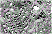
图5为应用本发明的遥感影像建筑物样本区域提取方法的得到的效果图;5 is an effect diagram obtained by applying the remote sensing image building sample area extraction method of the present invention;
图6为本发明的遥感影像建筑物样本区域提取系统的示意图。FIG. 6 is a schematic diagram of a system for extracting a sample area of a building from a remote sensing image according to the present invention.
具体实施方式Detailed ways
下面,结合附图以及具体实施方式,对本发明做进一步描述,需要说明的是,在不相冲突的前提下,以下描述的各实施例之间或各技术特征之间可以任意组合形成新的实施例。The present invention will be further described below with reference to the accompanying drawings and specific embodiments. It should be noted that, on the premise of no conflict, the embodiments or technical features described below can be combined arbitrarily to form new embodiments. .
遥感影像建筑物样本区域提取方法,如图1、2所示,包括如下步骤:The extraction method of remote sensing image building sample area, as shown in Figures 1 and 2, includes the following steps:
S1、样本制作,采集遥感影像,对目标区域的所述遥感影像进行分割裁剪得到包括分类对象的面矢量框文件,并标注所述面矢量文件中的带建筑物标签,将标签为带建筑物的所述面矢量样本的矢量数据转换成栅格数据,得到栅格化的建筑物样本;若干个带有建筑物标签的样本构成样本集,并将所述面矢量框文件加入所述样本集;其中所述建筑物样本的尺寸包括长为X像素,宽为Y像素;在一个实施例中,以一个县域为目标区域作业区的高空间分辨率遥感影像为输入,该影像的空间分辨率高于1米;在目标区域的遥感影像中随机裁切3个长X为1000像素、宽Y为1000像素的带建筑的影像标注样本。一般地,X、Y的优选取值范围为600-1000像素。S1, sample making, collecting remote sensing images, segmenting and cutting the remote sensing images of the target area to obtain a surface vector frame file including a classification object, and marking the label with buildings in the surface vector file, and labeling the label as with buildings The vector data of the surface vector samples are converted into raster data to obtain rasterized building samples; several samples with building labels constitute a sample set, and the surface vector frame file is added to the sample set ; Wherein the size of the building sample includes a length of X pixels and a width of Y pixels; In one embodiment, with a county as the input of the high spatial resolution remote sensing image of the target area operation area, the spatial resolution of the image is Above 1 meter; randomly crop 3 image annotation samples with buildings with a length X of 1000 pixels and a width Y of 1000 pixels in the remote sensing image of the target area. Generally, the preferred value range of X and Y is 600-1000 pixels.
利用D-LinkNet网络对样本集进行训练学习得到建筑物模型,D-LinkNet网络为一种深度卷积网络用于语义分割,其网络参数文件格式为PyTorch0.2.0描述格式。在另一个实施例中,建筑物模型可以从网络上选取,与步骤S1中具有相同分辨率的影像样本训练学习好的网络参数文件作为建筑物模型。在标注样本时,新建一个与样本裁切影像尺寸一致的8位栅格图层和一个样本区域的空间范围矢量框即面矢量框文件,每一个像素初始值设置为0,对建筑屋顶所对应的像素值为1,将标注好的3个样本放入本次需要训练的样本集中,将样本区域所在的空间范围矢量框加入本次训练样本集的矢量数据层中。所述目标区域所需标注的样本数量的最大值为M,M的计算公式为:The building model is obtained by training and learning the sample set using the D-LinkNet network. The D-LinkNet network is a deep convolutional network used for semantic segmentation, and its network parameter file format is the PyTorch0.2.0 description format. In another embodiment, the building model can be selected from the network, and the network parameter file trained and learned with the image samples having the same resolution as in step S1 is used as the building model. When labeling the sample, create a new 8-bit raster layer with the same size as the sample cropped image and a spatial range vector frame of the sample area, that is, the surface vector frame file. The initial value of each pixel is set to 0, which corresponds to the building roof. The pixel value of 1 is 1, put the marked 3 samples into the sample set that needs to be trained this time, and add the spatial range vector frame where the sample area is located to the vector data layer of this training sample set. The maximum value of the number of samples to be marked in the target area is M, and the calculation formula of M is:
M=S/50M=S/50
其中,S为所述目标区域的总面积(单位为平方公里);Wherein, S is the total area of the target area (unit is square kilometers);
所述目标区域当前的样本数量记为m。The current number of samples in the target area is denoted as m.
S2、建筑物预测,将待测试的遥感影像数据输入利用当前所述样本集训练好的建筑物模型并对所述目标区域的遥感影像进行预测,得到遥感影像中栅格化的建筑物数据;所述建筑物数据中的每个栅格的取值范围为第一阈值范围,其中最大值代表最高概率属于建筑,最小值代表最高概率属于非建筑;在一个实施例中,利用D-LinkNet网络对所述样本集进行模型训练,得到建筑物模型;将遥感影像数据输入所述建筑物模型,利用所述建筑物模型对目标区域遥感影像进行预测,得到遥感影像中栅格化的建筑物数据即建筑的强度图,如图3所示,该强度图是与目标区域影像尺寸相同的栅格图,每个栅格取值范围为[0-255],255最高概率是属于建筑,0代表最高概率属于非建筑。S2, building prediction, input the remote sensing image data to be tested into a building model trained using the current sample set and predict the remote sensing image of the target area to obtain rasterized building data in the remote sensing image; The value range of each grid in the building data is the first threshold range, wherein the maximum value represents that the highest probability belongs to a building, and the minimum value represents that the highest probability belongs to a non-building; in one embodiment, the D-LinkNet network is used. Perform model training on the sample set to obtain a building model; input the remote sensing image data into the building model, and use the building model to predict the remote sensing image of the target area to obtain rasterized building data in the remote sensing image That is, the intensity map of the building, as shown in Figure 3, the intensity map is a grid map with the same size as the target area image, and the value range of each grid is [0-255]. The highest probability of 255 belongs to the building, and 0 represents The highest probability belongs to non-buildings.
进一步地,S3、优化数据,将所述建筑物数据的每个栅格的取值范围位于第二阈值范围内的进行保留,同时将所述建筑物数据的其他取值的栅格全部标记为0,所述第二阈值包含于所述第一阈值,得到优化的建筑物数据。在一个实施例中,对步骤S2中的得到的建筑物数据进行筛选,对强度图保留强度值范围为[50-150]的栅格值,其余栅格值的设置为0,构成新的优化的建筑物数据。一般地,强度值在150-255范围内的栅格值与已经标注的样本的建筑极为相近,而0-50范围内的栅格值为非建筑,故强度图的强度值保留50-150的栅格值是与已经标注的建筑样本有相似但是又不同的建筑样本。并且将与已经标注的建筑样本极为相近的建筑样本即强度值在150-255范围内的栅格值不作为新增的建筑样本,如此减少了任务所需样本的数量且增强了样板的典型性与有效性。Further, in S3, optimizing the data, the value range of each grid of the building data is kept within the second threshold range, and the grids of other values of the building data are all marked as 0, the second threshold is included in the first threshold to obtain optimized building data. In one embodiment, the building data obtained in step S2 is screened, grid values with an intensity value range of [50-150] are reserved for the intensity map, and the rest grid values are set to 0, forming a new optimization building data. Generally, the grid values with the intensity value in the range of 150-255 are very similar to the buildings in the labeled samples, while the grid values in the range of 0-50 are non-buildings, so the intensity value of the intensity map remains 50-150. Raster values are building samples that are similar but different from the already labeled building samples. And the building samples that are very similar to the already marked building samples, that is, the grid values with the intensity value in the range of 150-255, are not used as the newly added building samples, which reduces the number of samples required for the task and enhances the typicality of the model. and effectiveness.
S4、卷积计算,利用与所述建筑物样本尺寸相同的矩阵窗口对所述建筑物数据进行全卷积相乘,当矩阵窗口与其对应的所述建筑强度影像区域的卷积相乘结果大于阈值E值时,将当前所述矩阵窗口所对应的所述面矢量框文件进行标记并放入样本待选区域列表;所述矩阵窗口的每个栅格的取值均为P;S4, convolution calculation, use the matrix window with the same size as the building sample to perform full convolution multiplication on the building data, when the matrix window and the corresponding convolution multiplication result of the building intensity image area are greater than When the threshold value E is the value, the surface vector frame file corresponding to the current matrix window is marked and placed in the list of sample regions to be selected; the value of each grid of the matrix window is P;
所述阈值E的计算公式如下:The calculation formula of the threshold E is as follows:
E=10·X·Y·max[1,(10-t-1)]/P,E=10·X·Y·max[1,(10-t-1)]/P,
其中,t为所述矩阵窗口在所述建筑物数据上移动的次数;Wherein, t is the number of times the matrix window moves on the building data;
在一个实施例中,以尺寸为1000x1000像素,取值全为1即P的取值为1的矩阵窗口对优化的建筑物数据进行全卷积相乘,移动的矩阵窗口每移动一次t增加1,比如矩阵窗口与建筑物数据进行第一次全卷积相乘时,t记为1;第一次全卷积相乘完成,矩阵窗口移动进行第二次全卷积相乘,t记为2,以此类推。如图3所示,是建筑物数据进行第二次迭代后的强度影像图。In one embodiment, a matrix window whose size is 1000×1000 pixels and whose value is all 1, that is, whose value of P is 1, performs full convolution and multiplication on the optimized building data, and t increases by 1 every time the moving matrix window moves. , for example, when the matrix window and building data are multiplied by the first full convolution, t is recorded as 1; the first full convolution multiplication is completed, and the matrix window moves for the second full convolution multiplication, and t is recorded as 2, and so on. As shown in Figure 3, it is the intensity image of the building data after the second iteration.
S5、精度评定,从所述样本待选区域列表中选择n个所述面矢量框文件进行样本标注;S5. Accuracy evaluation, selecting n of the surface vector frame files from the sample candidate area list for sample labeling;
当n大于0时,从所述样本待选区域列表中选择所述卷积相乘的结果最小的[n/2]个区域和所述卷积相乘的结果最大的n-[n/2]个区域返回步骤S1修改样本重新迭代训练;其中“[]”为取整符号;当n等于0时,进入下个步骤;在一个实施例中,n的计算公式如下:When n is greater than 0, select [n/2] areas with the smallest result of the convolution multiplication and n-[n/2 areas with the largest result of the convolution multiplication from the sample candidate area list ] area returns to step S1 to modify the sample to re-iteratively train; wherein "[]" is a rounding symbol; when n is equal to 0, enter the next step; in one embodiment, the calculation formula of n is as follows:
n=max[N,(M-m)/2]n=max[N,(M-m)/2]
其中,N为步骤S4中的所述样本待选区域列表的样本数量,m为所述目标区域当前的样本数量;M为所述目标区域所需标注的样本数量的最大值。当n大于0时,选择样本待选区域列表中卷积相乘的结果最小的[n/2]个区域和卷积相乘的结果最大的n-[n/2]个区域同时进行样本标注;当n等于0时,则进入步骤6;其中“[]”为取整符号。Wherein, N is the number of samples in the sample candidate area list in step S4, m is the current number of samples in the target area, and M is the maximum number of samples that need to be marked in the target area. When n is greater than 0, select [n/2] areas with the smallest convolution multiplication result and n-[n/2] areas with the largest convolution multiplication result in the sample candidate area list for sample labeling at the same time ; When n is equal to 0, go to step 6; where "[]" is the rounding symbol.
S6、结果矢量化,将当前的所述建筑物数据进行二值化并进行矢量化得到标记样本区域的遥感影像建筑物数据。在一个实施例中,当n=0时,样本的数量确定并得到最后一次建筑物数据图即强度图,将强度图进行二值化并取其阈值范围为30-70,获得建筑物屋顶预测结果,并进行矢量化,输出提取结果。S6. The result is vectorized, and the current building data is binarized and vectorized to obtain remote sensing image building data of the marked sample area. In one embodiment, when n=0, the number of samples is determined and the last building data map, that is, the intensity map is obtained, the intensity map is binarized and its threshold range is 30-70, and the building roof prediction is obtained The result is vectorized, and the extraction result is output.
在一个具体的实施例中,在一个1150平方公里县域的建筑屋顶提取任务中,在有周边三个县域(分别用的样本数为111个、62个、111个)的已训练好的网络参数模型基础上,应用本发明的提取方法,在提取效果等同的前提下,可将样本数减少至28个。不仅减少了任务所需样本的数量同时增强了典型样本区域选择的自动化程度和有效性,且节省了人工标注的工作量。In a specific embodiment, in a building roof extraction task in a county of 1150 square kilometers, there are three surrounding counties (the number of samples used are 111, 62, and 111 respectively). The trained network parameters On the basis of the model, by applying the extraction method of the present invention, the number of samples can be reduced to 28 under the premise of the same extraction effect. It not only reduces the number of samples required for the task, but also enhances the automation and effectiveness of typical sample region selection, and saves the workload of manual labeling.
一种电子设备,包括:处理器;An electronic device, comprising: a processor;
存储器;以及程序,其中所述程序被存储在所述存储器中,并且被配置成由处理器执行,所述程序包括用于执行遥感影像建筑物样本区域提取方法。a memory; and a program, wherein the program is stored in the memory and configured to be executed by a processor, the program including a method for performing a remote sensing image building sample area extraction method.
一种计算机可读存储介质,其上存储有计算机程序,所述计算机程序被处理器执行遥感影像建筑物样本区域提取方法。A computer-readable storage medium on which a computer program is stored, the computer program being executed by a processor to extract a sample area of a building from a remote sensing image.
遥感影像建筑物样本区域提取系统,如图6所示,包括:样本制作模块、建筑物预测模块、卷积计算模块、精度评定模块和结果矢量化模块;其中,The remote sensing image building sample area extraction system, as shown in Figure 6, includes: a sample production module, a building prediction module, a convolution calculation module, an accuracy evaluation module and a result vectorization module; among them,
所述样本制作模块用于采集遥感影像,对目标区域的所述遥感影像进行分割裁剪得到包括分类对象的面矢量框文件,并标注所述面矢量文件中的带建筑物标签,将标签为带建筑物的所述面矢量样本的矢量数据转换成栅格数据,得到栅格化的建筑物样本;若干个带有建筑物标签的样本构成样本集,并将所述面矢量框文件加入所述样本集;其中所述建筑物样本的尺寸包括长为X像素,宽为Y像素;The sample making module is used to collect remote sensing images, segment and cut the remote sensing images of the target area to obtain a surface vector frame file including classified objects, and mark the label with buildings in the surface vector file, and label the label as a band. The vector data of the surface vector samples of the building is converted into raster data to obtain rasterized building samples; several samples with building labels form a sample set, and the surface vector frame file is added to the A sample set; wherein the size of the building sample includes a length of X pixels and a width of Y pixels;
所述建筑物预测模块用于将待测试的遥感影像数据输入利用当前所述样本集训练好的建筑物模型并对所述目标区域的遥感影像进行预测,得到遥感影像中栅格化的建筑物数据;所述建筑物数据中的每个栅格的取值范围为第一阈值范围,其中最大值代表最高概率属于建筑,最小值代表最高概率属于非建筑;The building prediction module is used to input the remote sensing image data to be tested into a building model trained by using the current sample set and predict the remote sensing image of the target area, so as to obtain the rasterized building in the remote sensing image. data; the value range of each grid in the building data is the first threshold range, where the maximum value represents that the highest probability belongs to a building, and the minimum value represents that the highest probability belongs to a non-building;
所述卷积计算模块用于利用与所述建筑物样本尺寸相同的矩阵窗口对所述建筑物数据进行全卷积相乘,当矩阵窗口与其对应的所述建筑强度影像区域的卷积相乘结果大于阈值E时,将当前所述矩阵窗口所对应的所述面矢量框文件进行标记并放入样本待选区域列表;所述矩阵窗口的每个栅格的取值均为P;The convolution calculation module is used to perform full convolution multiplication on the building data by using a matrix window with the same size as the building sample, when the matrix window is multiplied by the convolution of the corresponding building intensity image area. When the result is greater than the threshold value E, mark the surface vector box file corresponding to the current matrix window and put it into the list of sample regions to be selected; the value of each grid of the matrix window is P;
所述阈值E的计算公式如下:The calculation formula of the threshold E is as follows:
E=10·X·Y·max[1,(10-t-1)]/P,E=10·X·Y·max[1,(10-t-1)]/P,
其中,t为所述矩阵窗口在所述建筑物数据上移动的次数;Wherein, t is the number of times the matrix window moves on the building data;
所述精度评定模块用于从所述样本待选区域列表中选择n个所述面矢量框文件进行样本标注;The accuracy evaluation module is configured to select n of the surface vector frame files from the sample candidate area list for sample labeling;
当n大于0时,从所述样本待选区域列表中选择所述卷积相乘的结果最小的[n/2]个区域和所述卷积相乘的结果最大的n-[n/2]个区域返回步骤S1修改样本重新迭代训练;其中“[]”为取整符号;当n等于0时,进入下个步骤;When n is greater than 0, select [n/2] areas with the smallest result of the convolution multiplication and n-[n/2 areas with the largest result of the convolution multiplication from the sample candidate area list ] area returns to step S1 to modify the samples to re-iteratively train; wherein "[]" is the rounding symbol; when n is equal to 0, enter the next step;
所述结果矢量化模块用于将当前的所述建筑物数据进行二值化并进行矢量化得到标记样本区域的遥感影像建筑物数据。The result vectorization module is used for binarizing and vectorizing the current building data to obtain remote sensing image building data of the marked sample area.
进一步地,还包括优化数据模块,所述优化数据模块用于将所述建筑物数据的每个栅格的取值范围位于第二阈值范围内的进行保留,同时将所述建筑物数据的其他取值的栅格全部标记为0,所述第二阈值范围位于所述第一阈值范围之间,得到优化的建筑物数据;Further, it also includes an optimization data module, which is used for retaining the value range of each grid of the building data within the second threshold range, and simultaneously The grids of values are all marked as 0, and the second threshold range is located between the first threshold ranges to obtain optimized building data;
所述卷积计算模块包括计算单元,所述计算单元用于计算所述目标区域所需标注的样本数量的最大值为M,M的计算公式为:The convolution calculation module includes a calculation unit, and the calculation unit is used to calculate the maximum value of the number of samples to be marked in the target area, and the calculation formula of M is:
M=S/50M=S/50
其中,S为所述目标区域的总面积(单位为平方公里);Wherein, S is the total area of the target area (unit is square kilometers);
所述目标区域当前的样本数量记为m;The current number of samples in the target area is denoted as m;
在步骤S5中,n的计算公式如下:In step S5, the calculation formula of n is as follows:
n=max[N,(M-m)/2]n=max[N,(M-m)/2]
其中,N为步骤S4中的所述样本待选区域列表的样本数量。Wherein, N is the number of samples in the sample candidate region list in step S4.
以上,仅为本发明的较佳实施例而已,并非对本发明作任何形式上的限制;凡本行业的普通技术人员均可按说明书附图所示和以上而顺畅地实施本发明;但是,凡熟悉本专业的技术人员在不脱离本发明技术方案范围内,利用以上所揭示的技术内容而做出的些许更动、修饰与演变的等同变化,均为本发明的等效实施例;同时,凡依据本发明的实质技术对以上实施例所作的任何等同变化的更动、修饰与演变等,均仍属于本发明的技术方案的保护范围之内。The above are only preferred embodiments of the present invention, and do not limit the present invention in any form; any person of ordinary skill in the industry can smoothly implement the present invention as shown in the accompanying drawings and above; however, any Those skilled in the art, without departing from the scope of the technical solution of the present invention, make use of the above-disclosed technical content to make some changes, modifications and equivalent changes of evolution are equivalent embodiments of the present invention; at the same time, Any alteration, modification and evolution of any equivalent changes made to the above embodiments according to the essential technology of the present invention still fall within the protection scope of the technical solution of the present invention.
Claims (8)
Priority Applications (1)
| Application Number | Priority Date | Filing Date | Title |
|---|---|---|---|
| CN201910506618.8A CN110298348B (en) | 2019-06-12 | 2019-06-12 | Remote sensing image building sample area extraction method and system, storage medium and equipment |
Applications Claiming Priority (1)
| Application Number | Priority Date | Filing Date | Title |
|---|---|---|---|
| CN201910506618.8A CN110298348B (en) | 2019-06-12 | 2019-06-12 | Remote sensing image building sample area extraction method and system, storage medium and equipment |
Publications (2)
| Publication Number | Publication Date |
|---|---|
| CN110298348A CN110298348A (en) | 2019-10-01 |
| CN110298348B true CN110298348B (en) | 2020-04-28 |
Family
ID=68027895
Family Applications (1)
| Application Number | Title | Priority Date | Filing Date |
|---|---|---|---|
| CN201910506618.8A Active CN110298348B (en) | 2019-06-12 | 2019-06-12 | Remote sensing image building sample area extraction method and system, storage medium and equipment |
Country Status (1)
| Country | Link |
|---|---|
| CN (1) | CN110298348B (en) |
Families Citing this family (6)
| Publication number | Priority date | Publication date | Assignee | Title |
|---|---|---|---|---|
| CN111144487B (en) * | 2019-12-27 | 2023-09-26 | 二十一世纪空间技术应用股份有限公司 | Method for establishing and updating remote sensing image sample library |
| CN111783860A (en) * | 2020-06-22 | 2020-10-16 | 上海飞未信息技术有限公司 | A method and system for automatic image recognition of rural houses |
| CN112990001A (en) * | 2021-03-11 | 2021-06-18 | 中国电建集团华东勘测设计研究院有限公司 | Remote sensing image monomer building rapid and accurate extraction method applied to digital collection |
| CN113807301B (en) * | 2021-09-26 | 2024-06-07 | 武汉汉达瑞科技有限公司 | Automatic extraction method and automatic extraction system for newly-added construction land |
| CN115984559B (en) * | 2022-12-27 | 2024-01-12 | 二十一世纪空间技术应用股份有限公司 | Intelligent sample selection method and related device |
| CN116434009B (en) * | 2023-04-19 | 2023-10-24 | 应急管理部国家减灾中心(应急管理部卫星减灾应用中心) | Construction method and system for deep learning sample set of damaged building |
Citations (6)
| Publication number | Priority date | Publication date | Assignee | Title |
|---|---|---|---|---|
| CN108447062A (en) * | 2018-02-01 | 2018-08-24 | 浙江大学 | A kind of dividing method of the unconventional cell of pathological section based on multiple dimensioned mixing parted pattern |
| CN108491826A (en) * | 2018-04-08 | 2018-09-04 | 福建师范大学 | A kind of extraction method of remote sensing image building |
| CN109165623A (en) * | 2018-09-07 | 2019-01-08 | 北京麦飞科技有限公司 | Rice scab detection method and system based on deep learning |
| CN109446992A (en) * | 2018-10-30 | 2019-03-08 | 苏州中科天启遥感科技有限公司 | Remote sensing image building extracting method and system, storage medium, electronic equipment based on deep learning |
| CN109583586A (en) * | 2018-12-05 | 2019-04-05 | 东软睿驰汽车技术(沈阳)有限公司 | A kind of convolution kernel processing method and processing device |
| CN109871798A (en) * | 2019-02-01 | 2019-06-11 | 浙江大学 | A kind of remote sensing image building extracting method based on convolutional neural networks |
Family Cites Families (3)
| Publication number | Priority date | Publication date | Assignee | Title |
|---|---|---|---|---|
| CN107358204B (en) * | 2017-07-13 | 2020-11-03 | 西安电子科技大学 | A Multispectral Image Classification Method Based on Recoding and Deep Fusion Convolutional Networks |
| CN107527352B (en) * | 2017-08-09 | 2020-07-07 | 中国电子科技集团公司第五十四研究所 | Remote sensing ship target contour segmentation and detection method based on deep learning FCN network |
| CN108154145B (en) * | 2018-01-24 | 2020-05-19 | 北京地平线机器人技术研发有限公司 | Method and device for detecting position of text in natural scene image |
-
2019
- 2019-06-12 CN CN201910506618.8A patent/CN110298348B/en active Active
Patent Citations (6)
| Publication number | Priority date | Publication date | Assignee | Title |
|---|---|---|---|---|
| CN108447062A (en) * | 2018-02-01 | 2018-08-24 | 浙江大学 | A kind of dividing method of the unconventional cell of pathological section based on multiple dimensioned mixing parted pattern |
| CN108491826A (en) * | 2018-04-08 | 2018-09-04 | 福建师范大学 | A kind of extraction method of remote sensing image building |
| CN109165623A (en) * | 2018-09-07 | 2019-01-08 | 北京麦飞科技有限公司 | Rice scab detection method and system based on deep learning |
| CN109446992A (en) * | 2018-10-30 | 2019-03-08 | 苏州中科天启遥感科技有限公司 | Remote sensing image building extracting method and system, storage medium, electronic equipment based on deep learning |
| CN109583586A (en) * | 2018-12-05 | 2019-04-05 | 东软睿驰汽车技术(沈阳)有限公司 | A kind of convolution kernel processing method and processing device |
| CN109871798A (en) * | 2019-02-01 | 2019-06-11 | 浙江大学 | A kind of remote sensing image building extracting method based on convolutional neural networks |
Non-Patent Citations (1)
| Title |
|---|
| D-LinkNet: LinkNet with Pretrained Encoder and Dilated Convolution for High Resolution Satellite Imagery Road Extraction;Lichen Zhou,et.al;《2018 IEEE/CVF Conference on Computer Vision and Pattern Recognition Workshops》;20181231;全文 * |
Also Published As
| Publication number | Publication date |
|---|---|
| CN110298348A (en) | 2019-10-01 |
Similar Documents
| Publication | Publication Date | Title |
|---|---|---|
| CN110298348B (en) | Remote sensing image building sample area extraction method and system, storage medium and equipment | |
| CN112232371B (en) | American license plate recognition method based on YOLOv3 and text recognition | |
| CN112837315B (en) | A method for detecting defects in transmission line insulators based on deep learning | |
| CN110210475B (en) | License plate character image segmentation method based on non-binarization and edge detection | |
| WO2019163985A1 (en) | Feature representation device, feature representation method, and program | |
| CN110136170A (en) | A Method of Building Change Detection in Remote Sensing Imagery Based on Convolutional Neural Network | |
| CN110390251A (en) | A Semantic Segmentation Method of Image Text Based on Multi-Neural Network Model Fusion Processing | |
| CN116452850B (en) | Road ponding area identification method based on data mining and deep learning | |
| CN110533068B (en) | An Image Object Recognition Method Based on Classification Convolutional Neural Network | |
| Ver Hoef et al. | A primer on topological data analysis to support image analysis tasks in environmental science | |
| CN110866455B (en) | Pavement water body detection method | |
| CN113011528B (en) | Remote sensing image small target detection method based on context and cascade structure | |
| CN114549972B (en) | Strip mine stope extraction method, device, equipment and medium | |
| CN113807301B (en) | Automatic extraction method and automatic extraction system for newly-added construction land | |
| CN113537173B (en) | A Face Image Authenticity Recognition Method Based on Facial Patch Mapping | |
| Cai et al. | A comparative study of deep learning approaches to rooftop detection in aerial images | |
| CN116597270B (en) | Road damage object detection method based on attention mechanism ensemble learning network | |
| CN117572457B (en) | Cross-scene multispectral point cloud classification method based on pseudo tag learning | |
| CN113537070A (en) | Detection method, detection device, electronic equipment and storage medium | |
| CN112990001A (en) | Remote sensing image monomer building rapid and accurate extraction method applied to digital collection | |
| CN106326451A (en) | Method for judging webpage sensing information block based on visual feature extraction | |
| CN103065296B (en) | High-resolution remote sensing image residential area extraction method based on edge feature | |
| CN116385889B (en) | Railway identification-based power inspection method and device and electronic equipment | |
| CN112149536B (en) | Squall line wind speed prediction method | |
| CN104866850A (en) | Optimized binarization method for document images |
Legal Events
| Date | Code | Title | Description |
|---|---|---|---|
| PB01 | Publication | ||
| PB01 | Publication | ||
| SE01 | Entry into force of request for substantive examination | ||
| SE01 | Entry into force of request for substantive examination | ||
| GR01 | Patent grant | ||
| GR01 | Patent grant | ||
| TR01 | Transfer of patent right | ||
| TR01 | Transfer of patent right |
Effective date of registration: 20200521 Address after: Kolding road high tech Zone of Suzhou City, Jiangsu Province, No. 78 215000 Co-patentee after: Aerospace Information Research Institute,Chinese Academy of Sciences Patentee after: SUZHOU ZHONGKETIANQI REMOTE SENSING TECHNOLOGY CO.,LTD. Address before: No. 18 Daoyuan Road, Science and Technology City, Suzhou High-tech Zone, Jiangsu Province Patentee before: SUZHOU ZHONGKETIANQI REMOTE SENSING TECHNOLOGY Co.,Ltd. |