CN109848996B - Large-scale three-dimensional environment map creation method based on graph optimization theory - Google Patents
Large-scale three-dimensional environment map creation method based on graph optimization theory Download PDFInfo
- Publication number
- CN109848996B CN109848996B CN201910208867.9A CN201910208867A CN109848996B CN 109848996 B CN109848996 B CN 109848996B CN 201910208867 A CN201910208867 A CN 201910208867A CN 109848996 B CN109848996 B CN 109848996B
- Authority
- CN
- China
- Prior art keywords
- mobile robot
- pose
- scale
- global
- time
- Prior art date
- Legal status (The legal status is an assumption and is not a legal conclusion. Google has not performed a legal analysis and makes no representation as to the accuracy of the status listed.)
- Expired - Fee Related
Links
Images




Landscapes
- Control Of Position, Course, Altitude, Or Attitude Of Moving Bodies (AREA)
Abstract
Description
技术领域technical field
本发明涉及移动机器人、导航定位和计算机视觉领域,具体涉及一种利用裁剪迭代最近点算法TrICP和快速的基于多尺度描述子对应传播算法顺序地估计移动机器人的局部位姿、利用自适应闭环假设和验证方法检测位姿图中的闭环、利用运动平均方法计算精确的移动机器人的全局位姿的方法。The invention relates to the fields of mobile robots, navigation and positioning and computer vision, in particular to a method for sequentially estimating the local pose of a mobile robot by using a clipping iterative closest point algorithm TrICP and a fast correspondence propagation algorithm based on multi-scale descriptors, and using an adaptive closed-loop assumption. And the verification method detects the closed loop in the pose graph and uses the motion average method to calculate the accurate global pose of the mobile robot.
背景技术Background technique
随着计算机和传感器设备的迅速发展,移动机器人技术已经广泛地应用于人类生产和生活相关的各个领域。移动机器人在自主执行各种任务的过程中,需要获得可靠的位姿信息,而位姿信息的获取依赖于精确的环境地图。为此,除了安装各种执行机构外,移动机器人上还必须安装大量的例如激光雷达、声纳、红外相机和视觉相机等感知设备。这些安装了多种传感器的移动机器人可用于采集环境感知信息,然后借助于同步定位与地图创建(Simultaneous Localization and Mapping,SLAM)技术创建合适的环境地图并实现其自身的可靠定位,以保证移动机器人顺利执行各种任务。目前,很多自主移动机器人均具备SLAM功能。这些自主移动机器人已在各个领域得到广泛应用,主要包括:无人驾驶汽车,农林业,服务业、军事和矿产资源开采等领域。下面将介绍SLAM技术在上述几个领域中的应用:With the rapid development of computer and sensor equipment, mobile robot technology has been widely used in various fields related to human production and life. In the process of autonomously performing various tasks, mobile robots need to obtain reliable pose information, and the acquisition of pose information depends on accurate environment maps. To this end, in addition to installing various actuators, a large number of sensing devices such as lidar, sonar, infrared cameras, and vision cameras must also be installed on mobile robots. These mobile robots installed with various sensors can be used to collect environmental perception information, and then use the Simultaneous Localization and Mapping (SLAM) technology to create appropriate environmental maps and achieve their own reliable positioning to ensure mobile robots. Perform various tasks smoothly. At present, many autonomous mobile robots have the SLAM function. These autonomous mobile robots have been widely used in various fields, mainly including: unmanned vehicles, agriculture and forestry, service industry, military and mineral resource mining and other fields. The following will introduce the application of SLAM technology in the above fields:
1)无人驾驶汽车1) Driverless cars
无人驾驶车是当今人工智能领域的热点问题,它在国防和智能辅助安全驾驶等领域有着广泛应用,研究具有人工智能的无人驾驶平台可减少战场上和交通事故中的人员伤亡。与普通车相比,无人驾驶车增加了诸如激光雷达,毫米波雷达,视觉相机和红外相机等传感器。它在行驶的过程中需要借助于这些传感器采集车体周围环境的感知信息,然后利用相关的SLAM算法和技术将感知信息转化成计算机能够理解的环境地图,并提供给规划模块进行运动规划,以获得合适的控制输入量驱动无人驾驶车向前行驶。现有无人驾驶车定位严重的依赖于GPS信号,在无GPS信号的环境下,SLAM技术的重要性将显得更加突出。Unmanned vehicles are a hot issue in the field of artificial intelligence today. They are widely used in national defense and intelligent assisted safe driving. Research on unmanned platforms with artificial intelligence can reduce casualties on the battlefield and in traffic accidents. Compared with ordinary cars, driverless cars have added sensors such as lidar, millimeter-wave radar, vision cameras, and infrared cameras. In the process of driving, it needs to use these sensors to collect the perception information of the surrounding environment of the car body, and then use the relevant SLAM algorithm and technology to convert the perception information into an environment map that the computer can understand, and provide it to the planning module for motion planning to Getting the right control inputs to drive the driverless car forward. The positioning of existing unmanned vehicles relies heavily on GPS signals. In the absence of GPS signals, the importance of SLAM technology will become more prominent.
2)矿产资源开采2) Mining of mineral resources
矿产资源是人类生产和生活的必需品,因此如何合理地开采和利用矿产资源是人类面临的一大挑战。在中国,澳大利亚和美国等资源大国,存在着数以万计的矿井,能否绘制精确的矿井地图,对于资源的合理开采和矿难救援均可起到关键的作用。而采用人工绘制矿井地图的方式即费时又无法保证精确性和可靠性,对于一些存在安全隐患的废弃矿井,人工根本无法绘制出可靠和精确的矿井地图。目前,国内矿难事故频发,救援人员在救援过程中急需精确的矿井地图。为此,可在矿车上安装计算平台、激光雷达传感器和视频采集设备,然后利用SLAM算法和技术自主地绘制出二维或三维矿井地图。与人工绘制方式相比,利用移动机器人绘制地图的方式更加可靠且精确,目前SLAM技术已成功应用于矿井地图的绘制工作中。但对于规模较大的矿井,其地图创建仍然是一个有待解决的问题。Mineral resources are the necessities of human production and life, so how to rationally exploit and utilize mineral resources is a major challenge for human beings. There are tens of thousands of mines in resource-rich countries such as China, Australia, and the United States. Whether an accurate mine map can be drawn can play a key role in the rational exploitation of resources and the rescue of mine disasters. However, the method of manually drawing a mine map is time-consuming and cannot guarantee accuracy and reliability. For some abandoned mines with potential safety hazards, it is impossible to draw a reliable and accurate mine map manually. At present, domestic mining accidents are frequent, and rescuers are in urgent need of accurate mine maps during the rescue process. To this end, a computing platform, lidar sensor and video acquisition equipment can be installed on the mining truck, and then SLAM algorithms and technologies can be used to autonomously draw a two-dimensional or three-dimensional mine map. Compared with manual drawing, the method of using mobile robots to draw maps is more reliable and accurate. At present, SLAM technology has been successfully applied to the drawing of mine maps. But for larger mines, its map creation is still an open problem.
3)农林业种植与防护3) Agriculture and forestry planting and protection
树木覆盖着全球大部分面积并且对二氧化碳下降、动物群落、水文湍流调节和巩固土壤起着重要作用,是构成地球生物圈当中的一个最重要方面。但木材又是工业、农业和建筑等行业的重要原材料,因此如何高效地种植树木和有效地利用树木也是一个重要的问题。为了保证树木的快速生长,需要合理控制树木的密度;为了有效地利用树木资源,需要了解树木的大小以及已成材树木的位置。虽然人工也能完成上述工作,但成本较高且精度较低,而利用安装了激光雷达和视觉传感器的移动机器人,通过设计合理的运动路径,并借助于SLAM算法和技术,即可快速自主地获得精确的林区树木分布地图。该地图中除了包含树木的位置信息外,还可包含树木的大小信息,这些结果可用于控制林区树木的种植密度,以便高效地种植树木和有效地利用木材。目前加拿大、芬兰等国家的研究者已将SLAM技术用于辅助工人进行林业种植与防护,此外SLAM技术已逐渐在农业种植中得到应用,但大多只能在平地上实现同步定位与地图创建。Trees cover most of the globe and play an important role in carbon dioxide decline, animal communities, hydrological turbulence regulation and soil consolidation, and constitute one of the most important aspects of Earth's biosphere. But wood is also an important raw material for industries such as industry, agriculture and construction, so how to efficiently plant trees and use them efficiently is also an important issue. In order to ensure the rapid growth of trees, the density of trees needs to be reasonably controlled; in order to use tree resources effectively, it is necessary to understand the size of trees and the location of mature trees. Although the above work can also be done manually, the cost is high and the accuracy is low. Using a mobile robot equipped with lidar and vision sensors, by designing a reasonable motion path, and with the help of SLAM algorithms and technologies, it can quickly and autonomously Obtain accurate tree distribution maps in forest areas. In addition to tree location information, the map also contains tree size information, and these results can be used to control the planting density of trees in forest areas for efficient tree planting and efficient use of wood. At present, researchers in Canada, Finland and other countries have used SLAM technology to assist workers in forest planting and protection. In addition, SLAM technology has been gradually applied in agricultural planting, but most of them can only achieve simultaneous positioning and map creation on flat ground.
4)家庭和社会服务4) Family and social services
人口老龄化问题是全球面临的一个重要问题。为解决人口老龄化等所导致的家庭和社会服务问题,研发出具有高性价比的家庭和社会服务机器人已成为了许多研究机构和公司的关注点,这些服务机器人可替代人工执行自主吸尘,搬运物件和导航服务等功能。而执行上述任务一个最基本的前提是服务机器人能实现自身的精确定位和导航,一种简单可靠的方法是在服务机器人上安装一些传感器,并按一定的规则在室内运动并采集环境数据,然后利用SLAM算法和技术建立一幅完整的室内环境地图。在执行日常的服务时,可采用SLAM算法实现服务机器人的精确定位以及动态地修改环境地图。但对于包含较多运动物体的环境,家庭和社会服务移动机器人的SLAM算法需要进一步提高可靠性和稳定性。Population aging is an important issue facing the world. In order to solve the family and social service problems caused by the aging of the population, the development of cost-effective family and social service robots has become the focus of many research institutions and companies. These service robots can replace manual autonomous vacuuming and handling. Objects and Navigation Services. One of the most basic prerequisites for performing the above tasks is that the service robot can achieve its own precise positioning and navigation. A simple and reliable method is to install some sensors on the service robot, move indoors according to certain rules and collect environmental data, and then Use SLAM algorithm and technology to build a complete indoor environment map. When performing daily services, the SLAM algorithm can be used to achieve precise positioning of the service robot and dynamically modify the environment map. However, for environments containing many moving objects, the SLAM algorithm of mobile robots for home and social services needs to further improve reliability and stability.
5)特殊环境中的探索5) Exploration in a special environment
地球上资源大部分为不可再生资源。随着人类文明的进步,人类可开采的资源已日益枯竭,这就促使人类探索特殊环境中的资源。在火山口、深海、北极、其它行星以及受污染的环境中可能蕴藏着各种丰富的资源,但受空气、压力和温度等因素的限制,人类目前还无法到达或长期驻扎在这些特殊环境中,因而限制了人类在这些环境中的活动。而移动机器人可以适应各种特殊的环境,因此研制具有勘探特殊环境功能的移动机器人是人工智能领域的一大热点。显然,在勘探的过程中需要对移动机器人进行可靠定位,而可靠的定位必须依赖于精确的环境地图,这些功能均可由安装了特殊传感器的移动机器人借助于SLAM技术实现。Most of the resources on earth are non-renewable resources. With the progress of human civilization, the resources that can be exploited by human beings have been increasingly exhausted, which prompts human beings to explore resources in special environments. There may be a variety of rich resources in craters, deep seas, the Arctic, other planets, and polluted environments, but limited by factors such as air, pressure, and temperature, humans are currently unable to reach or stay in these special environments for a long time. , thus limiting human activities in these environments. Mobile robots can adapt to various special environments, so the development of mobile robots with functions of exploring special environments is a hot spot in the field of artificial intelligence. Obviously, in the process of exploration, the mobile robot needs to be reliably positioned, and the reliable positioning must rely on the accurate environment map. These functions can be realized by the mobile robot equipped with special sensors with the help of SLAM technology.
总之,SLAM技术已经成为人工智能和移动机器人研究领域中及其重要且极富挑战性的课题。它不仅在陆地移动机器人上取得的广泛的应用,而且在水下移动机器人和空中移动机器人上也逐渐得到了应用。其目的是为了创建环境地图并实现移动机器人的精确定位,确保移动机器人可顺利地执行各项任务。虽然相关文献已给出了各种有效的解决方法,但大部分方法只适用于解决中小规模环境下的地图创建问题。而实际应用中,经常需要解决大规模环境下的地图创建问题。与中小规模环境下的地图创建问题,大规模环境下的地图创建问题更具复杂性。In conclusion, SLAM technology has become an important and challenging topic in the field of artificial intelligence and mobile robot research. It has been widely used not only in land mobile robots, but also in underwater mobile robots and aerial mobile robots. Its purpose is to create a map of the environment and achieve precise positioning of the mobile robot to ensure that the mobile robot can perform various tasks smoothly. Although the relevant literature has given various effective solutions, most of them are only suitable for solving the problem of map creation in small and medium-scale environments. In practical applications, it is often necessary to solve the problem of map creation in large-scale environments. The map creation problem in a large-scale environment is more complex than the map creation problem in the small and medium-scale environment.
发明内容SUMMARY OF THE INVENTION
本发明的目的在于克服现有的三维环境地图创建方法的缺点,提供一种基于图优化理论的大规模三维环境地图创建方法。The purpose of the present invention is to overcome the shortcomings of the existing three-dimensional environment map creation methods, and to provide a large-scale three-dimensional environment map creation method based on graph optimization theory.
为达到上述目的,本发明采用了以下技术方案。In order to achieve the above objects, the present invention adopts the following technical solutions.
一种基于图优化理论的大规模三维环境地图创建方法,包括以下步骤:A large-scale three-dimensional environment map creation method based on graph optimization theory, including the following steps:
1)获取移动机器人的局部位姿1) Obtain the local pose of the mobile robot
首先利用移动机器人搭载的激光扫描仪扫描周围环境获取三维点云,同时利用裁剪迭代最近点算法TrICP对相邻时刻采集的两帧三维点云进行配准,该算法的初始值为上一个时刻移动机器人的位姿变化值;获得配准结果后,需要对配准结果进行校验;如校验成功则将配准结果作为移动机器人的位姿估计结果输出,如校验失败,则利用快速的基于多尺度描述子对应传播算法重新估计移动机器人的局部位姿,该快速的基于多尺度描述子对应传播算法是对已有的基于多尺度描述子对应传播算法进行了加速,具体来说,是先对已经建立的种子匹配对根据在描述符D上的距离大小以降序方式进行了排序,然后只对前δ×100%(δ=0.3)的种子匹配对应用对应传播机制;Firstly, the laser scanner carried by the mobile robot is used to scan the surrounding environment to obtain the 3D point cloud. At the same time, the cropped iterative closest point algorithm TrICP is used to register the two frames of 3D point clouds collected at adjacent moments. The initial value of the algorithm is to move at the previous moment. The pose change value of the robot; after the registration result is obtained, the registration result needs to be verified; if the verification is successful, the registration result is output as the pose estimation result of the mobile robot; if the verification fails, the fast Based on the multi-scale descriptor correspondence propagation algorithm to re-estimate the local pose of the mobile robot, this fast multi-scale descriptor-based correspondence propagation algorithm accelerates the existing multi-scale descriptor-based correspondence propagation algorithm. Specifically, it is First, the established seed matching pairs are sorted in descending order according to the distance on the descriptor D, and then only the first δ×100% (δ=0.3) seed matching pairs are applied with the corresponding propagation mechanism;
通过结合裁剪迭代最近点算法和快速的基于多尺度描述子对应传播算法,得到移动机器人的局部位姿,随后利用下面的公式获取移动机器人的初始全局定位结果:By combining the clipping iterative nearest point algorithm and the fast multi-scale descriptor-based correspondence propagation algorithm, the local pose of the mobile robot is obtained, and then the initial global positioning result of the mobile robot is obtained by the following formula:

其中M1为4×4的单位矩阵,Mi+1和Mi分别表示移动机器人在i+1和i时刻的全局位姿,
2)闭环检测2) Closed loop detection
首先计算当前时刻移动机器人全局位姿与之前时刻全局位姿的欧式距离,假如该距离小于移动机器人在当前时刻自适应阈值,则假设检测到了闭环,然后利用快速的基于多尺度描述子对应传播算法对闭环假设所涉及当前和先前时刻所采集的两帧点云数据进行双视角全局配准,获得配准结果并判断相应的裁剪均方误差:如果裁剪均方误差小于β,则接受闭环假设;否则拒绝闭环假设;如果接受了当前的闭环假设,则设置这个环的权重为1/k,k表示检测到的闭环为第k个闭环。First, calculate the Euclidean distance between the global pose of the mobile robot at the current moment and the global pose of the previous moment. If the distance is less than the adaptive threshold of the mobile robot at the current moment, it is assumed that a closed loop is detected, and then a fast multi-scale descriptor-based correspondence propagation algorithm is used. Perform dual-view global registration on the two frames of point cloud data collected at the current and previous moments involved in the closed-loop hypothesis, obtain the registration result and judge the corresponding cropping mean square error: if the cropping mean square error is less than β, the closed-loop hypothesis is accepted; Otherwise, the closed-loop hypothesis is rejected; if the current closed-loop hypothesis is accepted, the weight of this loop is set to 1/k, where k indicates that the detected closed loop is the kth closed loop.
3)获取精确的移动机器人全局位姿3) Obtain the accurate global pose of the mobile robot
根据移动机器人的初始全局定位结果和闭环检测结果建立移动机器人相邻时刻和不同时刻的位姿约束方程,利用运动平均算法求解移动机器人相邻时刻和不同时刻的位姿约束方程,获取精确的移动机器人全局位姿;基于精确的移动机器人全局位姿,将各时刻获得的三维点云变换到全局坐标系下,进而得到精确的大规模三维环境地图。According to the initial global positioning results and closed-loop detection results of the mobile robot, the pose constraint equations of the mobile robot at adjacent moments and different moments are established, and the motion average algorithm is used to solve the pose constraint equations of the mobile robot at adjacent moments and different moments to obtain accurate movement. Robot global pose: Based on the accurate global pose of the mobile robot, the 3D point cloud obtained at each moment is transformed into the global coordinate system, and then an accurate large-scale 3D environment map is obtained.
步骤1)所述的对配准结果进行校验的公式为:The formula for checking the registration result described in step 1) is:

其中,θx表示当前时刻与上一个时刻的俯仰角变化值,θy表示当前时刻与上一个时刻的偏航角变化值,θz表示当前时刻与上一个时刻的翻滚角变化值,TMSE表示裁剪迭代最近点算法的裁剪均方误差,α和β表示设定的阈值,a取值为0.35,β取值为0.02。Among them, θ x represents the change value of the pitch angle between the current moment and the previous moment, θ y represents the change value of the yaw angle between the current moment and the previous moment, θ z represents the change value of the roll angle between the current moment and the previous moment, TMSE represents The clipping mean square error of the clipping iterative closest point algorithm, α and β represent the set thresholds, a is 0.35, and β is 0.02.
步骤2)所述的计算当前时刻移动机器人全局位姿与之前时刻全局位姿的欧式距离的公式为:Step 2) The formula for calculating the Euclidean distance between the global pose of the mobile robot at the current moment and the global pose of the previous moment is:
dij=||ti-tj||2 d ij =||t i -t j || 2
其中ti和tj分别表示移动机器人在i时刻和j时刻的全局位置。where t i and t j represent the global position of the mobile robot at time i and time j, respectively.
步骤2)所述的移动机器人在当前时刻自适应阈值的计算公式为:The calculation formula of the self-adaptive threshold value of the mobile robot described in step 2) at the current moment is:

其中c一个预设的参数,取值为0.1;di.i+1表示移动机器人在i时刻和i+1时刻全局位姿的欧氏距离,s为闭环假设的起始时刻,j为当前时刻。Among them, c is a preset parameter with a value of 0.1; d i.i+1 represents the Euclidean distance of the global pose of the mobile robot at time i and time i+1, s is the starting time of the closed-loop assumption, and j is the current time.
步骤3)所述的建立的移动机器人相邻时刻的位姿约束方程为:The pose constraint equation of the established mobile robot at adjacent moments in step 3) is:

其中Mi+1和Mi分别表示移动机器人在i+1和i时刻的全局位姿,
步骤3)所述的建立的移动机器人不同时刻的位姿约束方程为:The pose constraint equations of the established mobile robot at different times in step 3) are:

其中Mi和Mj分别表示移动机器人在i和j时刻的全局位姿,
本发明首先通过集成裁剪迭代最近点算法和快速的基于多尺度描述子对应传播算法顺序地估计移动机器人的局部位姿,同时利用局部位姿递推地计算移动机器人的初始全局位姿并构造位姿图,图的顶点表示移动机器人各时刻的位姿,图的边表示相连位姿之间的约束;随后利用自适应闭环假设和验证方法检测位姿图中的闭环;最后通过运动平均方法求解位姿约束方程,得到精确的移动机器人的全局位姿。实验结果表明该方法可以很好地创建大规模三维环境地图。The present invention firstly estimates the local pose of the mobile robot sequentially by integrating the clipping iterative closest point algorithm and the fast correspondence propagation algorithm based on multi-scale descriptors, and at the same time uses the local pose to recursively calculate the initial global pose of the mobile robot and construct the pose. The pose graph, the vertices of the graph represent the pose of the mobile robot at each moment, and the edges of the graph represent the constraints between the connected poses; then the closed loop in the pose graph is detected by the adaptive closed-loop hypothesis and verification method; finally, the motion average method is used to solve the problem The pose constraint equation is used to obtain the accurate global pose of the mobile robot. The experimental results show that the method can well create large-scale 3D environment maps.
本发明有以下优点:The present invention has the following advantages:
1)将裁剪迭代最近点算法和快速的基于多尺度描述子对应传播算法结合起来估计移动机器人的局部位姿,保证了三维地图创建的效率和可靠性;1) Combine the clipping iterative nearest point algorithm and the fast multi-scale descriptor-based correspondence propagation algorithm to estimate the local pose of the mobile robot, which ensures the efficiency and reliability of 3D map creation;
2)采用自适应的闭环假设和验证方法,能够有效地检测位姿图中的闭环;2) Using an adaptive closed-loop hypothesis and verification method, the closed-loop in the pose graph can be effectively detected;
3)利用运动平均方法优化已经建立的位姿图,可以得到精确的移动机器人全局位姿。3) Using the motion average method to optimize the established pose graph, the accurate global pose of the mobile robot can be obtained.
附图说明Description of drawings
图1是本发明的流程示意图。FIG. 1 is a schematic flow chart of the present invention.
图2是快速的基于多尺度描述子对应传播算法的原理图。Figure 2 is a schematic diagram of a fast correspondence propagation algorithm based on multi-scale descriptors.
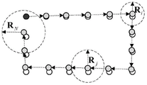
图3是闭环检测的示意图。Figure 3 is a schematic diagram of closed loop detection.
图4是建立约束方程,用运动平均算法优化的示意图。Figure 4 is a schematic diagram of establishing a constraint equation and optimizing it with a moving average algorithm.
图5是本发明与其他两种算法在Honnover2数据集上三维地图对比图,其中,图5(a)只采用裁剪迭代最近点算法的结果;图5(b)只采用裁剪迭代最近点算法和快速的基于多尺度描述子对应传播算法;图5(c)为本发明的结果。Figure 5 is a comparison diagram of the present invention and other two algorithms on the Honnover2 data set of three-dimensional maps, wherein, Figure 5 (a) only adopts the result of the clipping iterative nearest point algorithm; Figure 5 (b) only adopts the clipping iterative nearest point algorithm and Fast correspondence propagation algorithm based on multi-scale descriptors; Fig. 5(c) is the result of the present invention.
具体实施方式Detailed ways
下面结合附图对本发明作进一步说明。The present invention will be further described below in conjunction with the accompanying drawings.
参见图1,基于图优化理论的大规模三维环境地图创建方法分为三部分,各个部分包括的步骤如下:Referring to Figure 1, the large-scale 3D environment map creation method based on graph optimization theory is divided into three parts, each part includes the following steps:
1)由裁剪迭代最近点算法和快速的基于多尺度描述子对应传播算法得到局部位姿,具体步骤如下:1) The local pose is obtained by the clipping iterative nearest point algorithm and the fast correspondence propagation algorithm based on multi-scale descriptors. The specific steps are as follows:
(1a)通过裁剪迭代最近点算法对相邻时刻采集获得的两帧三维点云进行配准;(1a) The two frames of 3D point clouds collected at adjacent moments are registered by the clipping iterative closest point algorithm;
(1b)获得配准结果后,对配准结果进行校验;如校验成功则可将配准结果作为移动机器人的位姿估计结果输出;(1b) After obtaining the registration result, verify the registration result; if the verification is successful, the registration result can be output as the pose estimation result of the mobile robot;
(1c)如校验失败,则利用快速的基于多尺度描述子对应传播算法重新估计移动机器人的局部位姿;(1c) If the verification fails, use the fast multi-scale descriptor correspondence propagation algorithm to re-estimate the local pose of the mobile robot;
图2为快速的基于多尺度描述子对应传播算法的原理图。首先要对移动机器人采集到的扫描数据进行降采样,接着计算多尺度描述符(N,D),其中N表示基于法线的描述符,D表示基于特征值的描述符。在得到三维扫描数据中每个点的多尺度描述符之后,可以对多尺度描述符D应用最近邻搜索,从而建立种子匹配对。接着对这些种子匹配对根据点对距离已降序的方式进行排序,然后对前δ×100%(δ=0.3)的应用对应传播机制。每个扩展后的种子匹配都可以利用RANSAC算法计算出移动机器人的局部位姿,根据裁剪均方误差的大小,可以找到最优的局部位姿Mbest。最后,可以用裁剪迭代最近点算法对得到的局部位姿进行进一步优化。Figure 2 is a schematic diagram of a fast correspondence propagation algorithm based on multi-scale descriptors. First, the scan data collected by the mobile robot is down-sampled, and then the multi-scale descriptor (N, D) is calculated, where N represents the normal-based descriptor and D represents the eigenvalue-based descriptor. After obtaining the multi-scale descriptors for each point in the 3D scan data, a nearest neighbor search can be applied to the multi-scale descriptors D to establish seed matching pairs. These seed matching pairs are then sorted according to how the point pair distances have been descended, and then the corresponding propagation mechanism is applied to the first δ×100% (δ=0.3). Each extended seed match can use the RANSAC algorithm to calculate the local pose of the mobile robot. According to the size of the clipping mean square error, the optimal local pose M best can be found. Finally, the resulting local pose can be further optimized using the cropped iterative closest point algorithm.
2)闭环检测,具体步骤如下:2) Closed-loop detection, the specific steps are as follows:
(2a)首先计算当前时刻移动机器人全局位姿与之前时刻全局位姿的欧式距离;(2a) First, calculate the Euclidean distance between the global pose of the mobile robot at the current moment and the global pose of the previous moment;
(2b)假如该距离小于在当前时刻自适应阈值,则假设检测到了闭环;(2b) If the distance is less than the adaptive threshold at the current moment, it is assumed that a closed loop is detected;
(2c)然后利用快速的基于多尺度描述子对应传播算法对检测到的闭环进行验证。(2c) The detected loop closures are then validated using a fast multi-scale descriptor-based correspondence propagation algorithm.
图3为闭环检测的原理图。当前时刻移动机器人全局位姿与之前时刻全局位姿的欧式距离的计算公式为:Figure 3 is a schematic diagram of closed-loop detection. The formula for calculating the Euclidean distance between the global pose of the mobile robot at the current moment and the global pose of the previous moment is:
dij=||ti-tj||2 d ij =||t i -t j || 2
其中ti和tj分别表示移动机器人在i时刻和j时刻的全局位置。where t i and t j represent the global position of the mobile robot at time i and time j, respectively.
由于存在累计误差问题,距离阈值大小应该与路径长度呈正相关,因此移动机器人在i时刻自适应阈值的计算公式为:Due to the cumulative error problem, the distance threshold should be positively correlated with the path length, so the calculation formula of the adaptive threshold of the mobile robot at time i is:

其中c是一个预设的参数,取值为0.1;di.i+1表示移动机器人在i时刻和i+1时刻全局位姿的欧氏距离,s为闭环假设的起始时刻,j为当前时刻。如果dij≤r s.t.1≤i<j,则形成闭环假设。随后利用快速的基于多尺度描述子对应传播算法对闭环假设所涉及当前和先前时刻所采集的点云数据进行双视角配准,获得配准结果并判断相应的裁剪均方误差;如果裁剪均方误差小于β,β取值为0.02,则接收闭环假设,否则拒绝闭环假设。where c is a preset parameter with a value of 0.1; d i.i+1 represents the Euclidean distance between the global pose of the mobile robot at time i and time i+1, s is the starting time of the closed-loop assumption, and j is current moment. If d ij ≤ r st1 ≤ i < j, a closed loop hypothesis is formed. Then use the fast multi-scale descriptor-based correspondence propagation algorithm to perform dual-view registration on the point cloud data collected at the current and previous moments involved in the closed-loop hypothesis, obtain the registration result and judge the corresponding clipping mean square error; if the clipping mean square error If the error is less than β, and the value of β is 0.02, the closed-loop hypothesis is accepted, otherwise the closed-loop hypothesis is rejected.
3)建立位姿约束方程,求解精确的移动机器人全局位姿,图4为建立位姿约束方程的示意图。具体步骤如下:3) Establish a pose constraint equation to solve the accurate global pose of the mobile robot. Figure 4 is a schematic diagram of establishing the pose constraint equation. Specific steps are as follows:
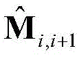
(3a)建立相邻时刻的位姿约束方程为:(3a) The pose constraint equation for establishing adjacent moments is:

其中Mi+1和Mi分别表示移动机器人在i+1和i时刻的全局位姿,
(3b)建立不同时刻的位姿约束方程为:(3b) The pose constraint equations at different times are established as:

其中Mi和Mj分别表示移动机器人在i+1和j时刻的全局位姿,
(3c)利用运动平均算法求解位姿约束方程,获得精确的移动机器人全局位姿。(3c) Use the motion average algorithm to solve the pose constraint equation to obtain the accurate global pose of the mobile robot.
本发明首先通过集成裁剪迭代最近点算法和快速的基于多尺度描述子对应传播算法顺序地估计移动机器人的局部位姿,提高了局部定位系统的精度、效率和鲁棒性;同时利用局部位姿递推地计算移动机器人的初始全局位姿并构造位姿图,图的顶点表示移动机器人各时刻的位姿,图的边表示相连位姿之间的约束;随后利用自适应闭环假设和验证方法检测位姿图中的闭环;最后通过运动平均方法求解位姿约束方程,得到精确的移动机器人的全局位姿。实验结果表明该方法可以很好地创建大规模三维环境地图。The invention firstly estimates the local pose of the mobile robot sequentially by integrating the iterative closest point algorithm for clipping and the fast correspondence propagation algorithm based on multi-scale descriptors, thereby improving the accuracy, efficiency and robustness of the local positioning system; meanwhile, using the local pose The initial global pose of the mobile robot is recursively calculated and a pose graph is constructed. The vertices of the graph represent the pose of the mobile robot at each moment, and the edges of the graph represent the constraints between the connected poses; then use the adaptive closed-loop hypothesis and verification method The closed loop in the pose graph is detected; finally, the pose constraint equation is solved by the motion average method, and the accurate global pose of the mobile robot is obtained. The experimental results show that the method can well create large-scale 3D environment maps.
根据图5,可以看出本发明在实际应用中的效果。该数据移动机器人在大学校园环境中的三维环境地图创建结果,移动机器人的行车路长度为1.24km,采集到924帧扫描数据,每帧扫描数据大约包含16600个点。图5(a)仅仅采用裁剪迭代最近点算法得到的结果,可以看到裁剪迭代最近点算法无法准确定位移动机器人的位置。图5(b)运动平均算法优化之前的结果,可以看到仅仅采用裁剪迭代最近点算法和快速的基于多尺度描述子对应传播算法会产生累计误差,无法得到精确的三维环境地图;图5(c)为本发明中的算法,可以看到本发明中的算法可以创建精确的三维环境地图。实验结果表明本发明可以为大规模环境有效地创建精确的三维环境地图。According to FIG. 5, the effect of the present invention in practical application can be seen. The data created the result of the 3D environment map of the mobile robot in the university campus environment. The length of the mobile robot's driving path is 1.24km, and 924 frames of scan data were collected, each frame of scan data contains about 16,600 points. Figure 5(a) is the result obtained by only using the clipping iterative nearest point algorithm. It can be seen that the clipping iterative nearest point algorithm cannot accurately locate the position of the mobile robot. Figure 5(b) The results before the optimization of the moving average algorithm, it can be seen that only using the clipping iterative nearest point algorithm and the fast multi-scale descriptor-based correspondence propagation algorithm will generate cumulative errors, and an accurate 3D environment map cannot be obtained; Figure 5( c) is the algorithm in the present invention, it can be seen that the algorithm in the present invention can create an accurate three-dimensional environment map. Experimental results show that the present invention can effectively create accurate three-dimensional environment maps for large-scale environments.
Claims (6)




Priority Applications (1)
| Application Number | Priority Date | Filing Date | Title |
|---|---|---|---|
| CN201910208867.9A CN109848996B (en) | 2019-03-19 | 2019-03-19 | Large-scale three-dimensional environment map creation method based on graph optimization theory |
Applications Claiming Priority (1)
| Application Number | Priority Date | Filing Date | Title |
|---|---|---|---|
| CN201910208867.9A CN109848996B (en) | 2019-03-19 | 2019-03-19 | Large-scale three-dimensional environment map creation method based on graph optimization theory |
Publications (2)
| Publication Number | Publication Date |
|---|---|
| CN109848996A CN109848996A (en) | 2019-06-07 |
| CN109848996B true CN109848996B (en) | 2020-08-14 |
Family
ID=66901285
Family Applications (1)
| Application Number | Title | Priority Date | Filing Date |
|---|---|---|---|
| CN201910208867.9A Expired - Fee Related CN109848996B (en) | 2019-03-19 | 2019-03-19 | Large-scale three-dimensional environment map creation method based on graph optimization theory |
Country Status (1)
| Country | Link |
|---|---|
| CN (1) | CN109848996B (en) |
Families Citing this family (6)
| Publication number | Priority date | Publication date | Assignee | Title |
|---|---|---|---|---|
| CN110645974B (en) * | 2019-09-26 | 2020-11-27 | 西南科技大学 | An indoor map construction method for mobile robots based on fusion of multi-sensors |
| CN111080682B (en) * | 2019-12-05 | 2023-09-01 | 北京京东乾石科技有限公司 | Registration method and device for point cloud data |
| CN111027140B (en) * | 2019-12-11 | 2020-09-22 | 南京航空航天大学 | Rapid reconstruction method of aircraft standard parts model based on multi-view point cloud data |
| CN111466905B (en) * | 2020-04-10 | 2021-01-22 | 西安交通大学 | Electrocardiographic waveform extraction method based on bidirectional communication |
| CN112991515B (en) | 2021-02-26 | 2022-08-19 | 山东英信计算机技术有限公司 | Three-dimensional reconstruction method, device and related equipment |
| CN113160130A (en) * | 2021-03-09 | 2021-07-23 | 北京航空航天大学 | Loop detection method and device and computer equipment |
Family Cites Families (8)
| Publication number | Priority date | Publication date | Assignee | Title |
|---|---|---|---|---|
| WO2012167110A2 (en) * | 2011-06-02 | 2012-12-06 | Honda Motor Co., Ltd. | Target recognition and localization methods using a laser sensor for wheeled mobile robots |
| CN104374395A (en) * | 2014-03-31 | 2015-02-25 | 南京邮电大学 | Graph-based vision SLAM (simultaneous localization and mapping) method |
| EP3078935A1 (en) * | 2015-04-10 | 2016-10-12 | The European Atomic Energy Community (EURATOM), represented by the European Commission | Method and device for real-time mapping and localization |
| CN106199626B (en) * | 2016-06-30 | 2019-08-09 | 上海交通大学 | Indoor 3D point cloud map generation system and method based on swing lidar |
| CN106272423A (en) * | 2016-08-31 | 2017-01-04 | 哈尔滨工业大学深圳研究生院 | A kind of multirobot for large scale environment works in coordination with the method for drawing and location |
| CN107316328B (en) * | 2017-05-11 | 2020-07-07 | 浙江大学 | A closed-loop detection method based on corner features of two-dimensional laser scanners |
| CN108332759A (en) * | 2018-01-12 | 2018-07-27 | 浙江国自机器人技术有限公司 | A kind of map constructing method and system based on 3D laser |
| CN109186608B (en) * | 2018-09-27 | 2021-10-15 | 大连理工大学 | A Relocalization-Oriented Sparse 3D Point Cloud Map Generation Method |
-
2019
- 2019-03-19 CN CN201910208867.9A patent/CN109848996B/en not_active Expired - Fee Related
Also Published As
| Publication number | Publication date |
|---|---|
| CN109848996A (en) | 2019-06-07 |
Similar Documents
| Publication | Publication Date | Title |
|---|---|---|
| CN109848996B (en) | Large-scale three-dimensional environment map creation method based on graph optimization theory | |
| CN112184736B (en) | Multi-plane extraction method based on European clustering | |
| CN109917818B (en) | Collaborative search and containment method based on ground robot | |
| Liu et al. | Point cloud segmentation based on Euclidean clustering and multi-plane extraction in rugged field | |
| Shan et al. | LiDAR-based stable navigable region detection for unmanned surface vehicles | |
| CN113223062B (en) | Point cloud registration method based on corner feature point selection and quick description | |
| CN110349192B (en) | A tracking method for online target tracking system based on 3D laser point cloud | |
| US12242270B2 (en) | Method and system for controlling multi-unmanned surface vessel collaborative search | |
| CN107289939B (en) | Unmanned ship path planning method based on SVM algorithm | |
| CN114034299B (en) | A navigation system based on active laser SLAM | |
| CN117152249A (en) | Multi-UAV collaborative mapping and perception method and system based on semantic consistency | |
| CN113343875A (en) | Driving region sensing method for robot | |
| Zeng et al. | An indoor 2-D LiDAR SLAM and localization method based on artificial landmark assistance | |
| Bao et al. | A systematic mapping framework for backpack mobile mapping system in common monotonous environments | |
| Jelavic et al. | Robotic precision harvesting: mapping, localization, planning and control for a legged tree harvester | |
| CN117406771A (en) | An efficient autonomous exploration method, system and equipment based on a quad-rotor drone | |
| CN114353799A (en) | Indoor rapid global positioning method for unmanned platform carrying multi-line laser radar | |
| CN102073848A (en) | Intelligent optimization-based road recognition system and method | |
| CN120351922A (en) | Cooperative linkage method for medical rescue unmanned aerial vehicle and robot dog | |
| CN111812978A (en) | A Multi-UAV Collaborative SLAM Method and System | |
| Tan et al. | A novel fusion positioning navigation system for greenhouse strawberry spraying robot using LiDAR and ultrasonic tags | |
| Zhang et al. | Research on AGV map building and positioning based on SLAM technology | |
| Zhou et al. | Vision SLAM algorithm for wheeled robots integrating multiple sensors | |
| Kanellakis et al. | Where to look: a collection of methods formav heading correction in underground tunnels | |
| CN113239520B (en) | A near-bottom three-dimensional underwater terrain environment modeling method |
Legal Events
| Date | Code | Title | Description |
|---|---|---|---|
| PB01 | Publication | ||
| PB01 | Publication | ||
| SE01 | Entry into force of request for substantive examination | ||
| SE01 | Entry into force of request for substantive examination | ||
| GR01 | Patent grant | ||
| GR01 | Patent grant | ||
| CF01 | Termination of patent right due to non-payment of annual fee | ||
| CF01 | Termination of patent right due to non-payment of annual fee |
Granted publication date: 20200814 |