CN115777123A - Map update device and map update program - Google Patents
Map update device and map update program Download PDFInfo
- Publication number
- CN115777123A CN115777123A CN202180048463.3A CN202180048463A CN115777123A CN 115777123 A CN115777123 A CN 115777123A CN 202180048463 A CN202180048463 A CN 202180048463A CN 115777123 A CN115777123 A CN 115777123A
- Authority
- CN
- China
- Prior art keywords
- data
- reliability
- map
- unit
- accumulated
- Prior art date
- Legal status (The legal status is an assumption and is not a legal conclusion. Google has not performed a legal analysis and makes no representation as to the accuracy of the status listed.)
- Withdrawn
Links
Images


Classifications
-
- G—PHYSICS
- G01—MEASURING; TESTING
- G01C—MEASURING DISTANCES, LEVELS OR BEARINGS; SURVEYING; NAVIGATION; GYROSCOPIC INSTRUMENTS; PHOTOGRAMMETRY OR VIDEOGRAMMETRY
- G01C21/00—Navigation; Navigational instruments not provided for in groups G01C1/00 - G01C19/00
- G01C21/38—Electronic maps specially adapted for navigation; Updating thereof
- G01C21/3804—Creation or updating of map data
- G01C21/3859—Differential updating map data
-
- G—PHYSICS
- G01—MEASURING; TESTING
- G01C—MEASURING DISTANCES, LEVELS OR BEARINGS; SURVEYING; NAVIGATION; GYROSCOPIC INSTRUMENTS; PHOTOGRAMMETRY OR VIDEOGRAMMETRY
- G01C21/00—Navigation; Navigational instruments not provided for in groups G01C1/00 - G01C19/00
- G01C21/38—Electronic maps specially adapted for navigation; Updating thereof
- G01C21/3804—Creation or updating of map data
- G01C21/3807—Creation or updating of map data characterised by the type of data
-
- G—PHYSICS
- G01—MEASURING; TESTING
- G01C—MEASURING DISTANCES, LEVELS OR BEARINGS; SURVEYING; NAVIGATION; GYROSCOPIC INSTRUMENTS; PHOTOGRAMMETRY OR VIDEOGRAMMETRY
- G01C21/00—Navigation; Navigational instruments not provided for in groups G01C1/00 - G01C19/00
- G01C21/38—Electronic maps specially adapted for navigation; Updating thereof
- G01C21/3804—Creation or updating of map data
- G01C21/3833—Creation or updating of map data characterised by the source of data
- G01C21/3841—Data obtained from two or more sources, e.g. probe vehicles
-
- G—PHYSICS
- G08—SIGNALLING
- G08G—TRAFFIC CONTROL SYSTEMS
- G08G1/00—Traffic control systems for road vehicles
- G08G1/01—Detecting movement of traffic to be counted or controlled
-
- G—PHYSICS
- G09—EDUCATION; CRYPTOGRAPHY; DISPLAY; ADVERTISING; SEALS
- G09B—EDUCATIONAL OR DEMONSTRATION APPLIANCES; APPLIANCES FOR TEACHING, OR COMMUNICATING WITH, THE BLIND, DEAF OR MUTE; MODELS; PLANETARIA; GLOBES; MAPS; DIAGRAMS
- G09B29/00—Maps; Plans; Charts; Diagrams, e.g. route diagram
Landscapes
- Engineering & Computer Science (AREA)
- Radar, Positioning & Navigation (AREA)
- Remote Sensing (AREA)
- Physics & Mathematics (AREA)
- General Physics & Mathematics (AREA)
- Automation & Control Theory (AREA)
- Theoretical Computer Science (AREA)
- Mathematical Physics (AREA)
- Business, Economics & Management (AREA)
- Educational Administration (AREA)
- Educational Technology (AREA)
- Instructional Devices (AREA)
- Traffic Control Systems (AREA)
- Navigation (AREA)
Abstract
本发明涉及地图更新装置以及地图更新程序。服务器(3)具备:统合地图生成部(19),基于包含被赋予可靠性的探测数据的多个输入地图来生成统合地图;可靠性判定部(20),判定由统合地图生成部生成的统合地图的可靠性;以及差分更新部(21),在由可靠性判定部判定为可靠性在第一规定等级以上的情况下,使被判定为该可靠性在第一规定等级以上的统合地图与基准地图的差分反映于基准地图并更新差分,以更新基准地图。

The present invention relates to a map updating device and a map updating program. The server (3) is equipped with: an integrated map generating unit (19) that generates an integrated map based on a plurality of input maps including probe data given reliability; a reliability judging unit (20) that judges the integrated map generated by the integrated map generating unit Reliability of the map; and the difference updating unit (21), when the reliability judging unit determines that the reliability is above the first predetermined level, combines the integrated map judged to have the reliability above the first predetermined level with the The difference of the reference map is reflected on the reference map and the difference is updated to update the reference map.
Description
相关申请的交叉引用Cross References to Related Applications
本申请基于2020年7月10日申请的日本申请编号2020-119191号,并在此引用其记载内容。This application is based on Japanese Application No. 2020-119191 filed on July 10, 2020, the contents of which are cited here.
技术领域technical field
本公开涉及地图更新装置以及地图更新程序。The present disclosure relates to a map update device and a map update program.
背景技术Background technique
提供如下的结构:基于多个输入地图来生成统合地图,并对该生成的统合地图和基准地图进行比较来判定有无差分,若判定有差分,则使差分反映于基准地图并更新差分,以更新基准地图。具体而言,在服务器中,根据输入地图所包含的探测数据来生成统合地图,若判定该生成的统合地图与基准地图有差分,则使差分反映于基准地图并更新差分,以更新基准地图。A structure is provided that generates an integrated map based on a plurality of input maps, compares the generated integrated map with a reference map to determine whether there is a difference, and if it is determined that there is a difference, reflects the difference on the reference map and updates the difference, so that Update the base map. Specifically, the server generates an integrated map based on the probe data included in the input map, and if it is determined that the generated integrated map differs from the reference map, the difference is reflected on the reference map and the difference is updated to update the reference map.
在对统合地图与基准地图进行比较来判定有无差分的结构中,期望统合地图的可靠性足够高,但也可能有统合地图的可靠性不够高的情况。若对可靠性不够高的统合地图与基准地图进行比较来判定差分的有无,并使差分反映于基准地图来更新差分,则不能够适当地更新基准地图,基准地图的精度降低。作为提高可靠性的结构,例如在专利文献1中公开了在服务器中,当存在多个针对同一道路的道路数据的情况下,计算各道路数据的可靠性,并基于该计算出的可靠性从多个道路数据中选择一个道路数据的结构。In the configuration of comparing the integrated map with the reference map to determine whether there is a difference, it is desirable that the reliability of the integrated map is sufficiently high, but there may be cases where the reliability of the integrated map is not high enough. If the integrated map with insufficient reliability is compared with the reference map to determine the presence or absence of a difference, and the difference is updated by reflecting the difference on the reference map, the reference map cannot be properly updated, and the accuracy of the reference map decreases. As a structure for improving reliability, for example, Patent Document 1 discloses that when there are a plurality of road data for the same road in the server, the reliability of each road data is calculated, and based on the calculated reliability, the A structure for selecting one road data among a plurality of road data.
专利文献1:日本特开2010-210948号公报Patent Document 1: Japanese Patent Laid-Open No. 2010-210948
在上述的专利文献1的方法中,不能够应对统合地图的可靠性不够高的情况,不能够避免基准地图的精度降低的可能性。The above-mentioned method of Patent Document 1 cannot cope with the case where the reliability of the integrated map is not high enough, and cannot avoid the possibility of the accuracy of the reference map being lowered.
发明内容Contents of the invention
本公开的目的在于适当地更新基准地图,并适当地避免基准地图的精度的降低。An object of the present disclosure is to appropriately update a reference map and appropriately avoid reduction in the accuracy of the reference map.
根据本公开的一方式,统合地图生成部基于包含被赋予可靠性的探测数据的多个输入地图来生成统合地图。若生成统合地图,则可靠性判定部判定该生成的统合地图的可靠性。若由可靠性判定部判定为可靠性在第一规定等级以上,则差分更新部使被判定为该可靠性在第一规定等级以上的统合地图与基准地图的差分反映于基准地图并更新差分,以更新基准地图。According to one aspect of the present disclosure, the integrated map generating unit generates the integrated map based on a plurality of input maps including probe data to which reliability is given. When the integrated map is generated, the reliability determination unit determines the reliability of the generated integrated map. If it is determined by the reliability determination unit that the reliability is above the first predetermined level, the difference update unit reflects the difference between the integrated map and the reference map determined to have reliability above the first predetermined level on the reference map and updates the difference, to update the base map.
判定统合地图的可靠性,若判定为可靠性在第一规定等级以上,则使判定为该可靠性在第一规定等级以上的统合地图与基准地图的差分反映于基准地图并更新差分,以更新基准地图。通过将统合地图的可靠性在第一规定等级以上设为更新基准地图的条件,能够适当地更新基准地图,能够适当地避免基准地图的精度的降低。Judging the reliability of the integrated map, if it is determined that the reliability is above the first predetermined level, the difference between the integrated map and the reference map determined to be above the first predetermined level is reflected on the reference map and the difference is updated to update Baseline map. By making the reliability of the integrated map equal to or higher than the first predetermined level as a condition for updating the reference map, the reference map can be appropriately updated and a reduction in the accuracy of the reference map can be appropriately avoided.
附图说明Description of drawings
关于本公开的上述目的以及其它目的、特征及优点,参照附图并通过下述的详细描述会变得更加明确。在该附图中:The above object and other objects, features, and advantages of the present disclosure will become more apparent from the following detailed description with reference to the accompanying drawings. In this attached drawing:
图1是表示一实施方式的地图更新系统的整体构成的功能框图,FIG. 1 is a functional block diagram showing the overall configuration of a map update system according to an embodiment,
图2是车载机中的控制部的功能框图,Fig. 2 is a functional block diagram of a control unit in the vehicle-mounted device,
图3是服务器中的控制部的功能框图,Fig. 3 is a functional block diagram of a control unit in the server,
图4是说明更新统合地图的处理的流程的图,FIG. 4 is a diagram illustrating the flow of processing for updating the integrated map,
图5是说明估计道路形状数据的处理的流程图(其一),FIG. 5 is a flowchart (Part 1) illustrating processing for estimating road shape data,
图6是说明估计道路形状数据的处理的流程图(其二),FIG. 6 is a flowchart (Part 2) illustrating the process of estimating road shape data,
图7是说明估计道路形状数据的处理的流程图(其三),FIG. 7 is a flowchart (Part 3) illustrating processing for estimating road shape data,
图8是流程图(其一),Fig. 8 is flow chart (one),
图9是流程图(其二)。Fig. 9 is a flowchart (Part 2).
具体实施方式Detailed ways
以下,参照附图对一实施方式进行说明。如图1所示,地图更新系统1构成为搭载在车辆侧的车载机2与配置在网络侧的服务器3能够进行数据通信。车载机2与服务器3处于多对一的关系,服务器3能够与多个车载机2之间进行数据通信。服务器3相当于地图更新装置。Hereinafter, an embodiment will be described with reference to the drawings. As shown in FIG. 1 , the map update system 1 is configured such that an on-vehicle device 2 mounted on a vehicle side and a
车载机2具备:控制部4、数据通信部5、图像数据输入部6、定位数据输入部7、传感器数据输入部8以及存储装置9,各功能模块构成为能够经由内部总线10进行数据通信。控制部4由具有CPU(Central Processing Unit:中央处理器)、ROM(Read Only Memory:只读存储器)、RAM(Random Access Memory:随机存取存储器)以及I/O(Input/Output:输入输出)的微型计算机构成。微型计算机执行储存于非迁移实体存储介质的计算机程序,执行与计算机程序对应的处理,控制车载机2的动作整体。The vehicle-mounted device 2 includes a
数据通信部5控制与服务器3之间的数据通信。车载相机11与车载机2独立地设置,拍摄车辆前方,并将其拍摄到的图像数据输出到车载机2。图像数据输入部6若从车载相机11输入图像数据,则将该输入的图像数据输出到控制部4。GNSS(Global NavigationSatellite System:全球导航卫星系统)接收机12与车载机2独立地设置,接收从GNSS卫星发送的卫星信号进行定位,并将该定位数据输出到车载机2。定位数据输入部7若从GNSS接收机12输入定位数据,则将该输入的定位数据输出到控制部4。各种传感器13与车载机2独立地设置,例如包含毫米波雷达、LiDAR(Light Detection and Ranging,Laser ImagingDetection and Ranging:光探测与测距、激光成像探测与测距)等,将测量出的传感器数据输出到车载机2。传感器数据输入部8若从各种传感器13输入传感器数据,则将该输入的传感器数据输出到控制部4。另外,车载相机11、GNSS接收机12以及各种传感器13也可以其一部分或者整体与车载机2一体地设置。The
如图2所示,控制部4具备:地上物数据生成部4a、可靠性生成部4b、探测数据生成部4c以及分发控制部4d。地上物数据生成部4a基于定位数据、图像数据以及传感器数据将车辆位置、定位出该车辆位置的时刻、道路上的标识、招牌等地标、划分线的位置等建立对应地生成与地上物相关的信息作为地上物数据。As shown in FIG. 2 , the
当由地上物数据生成部4a生成地上物数据时,可靠性生成部4b生成与该生成的地上物数据对应的可靠性。此处,可靠性例如包含位置可靠性和识别可靠性。位置可靠性是表示是否稳定地对绝对位置、相对位置进行定位的指标,是由侧滑、振动等急剧的位置变化的有无、对GNSS接收机12的定位造成影响的遮挡物的有无等表示的指标。即,如果没有侧滑、振动等急剧的位置变化,或者没有对GNSS接收机12的定位造成影响的遮挡物,则位置可靠性相对较高。如果有侧滑、振动等急剧的位置变化,或者有对GNSS接收机12的定位造成影响的遮挡物,则位置可靠性相对较低。识别可靠性是表示是否稳定地识别地上物数据的指标,是由车辆周边的照度、天气、前方车辆的有无等表示的指标。即,如果车辆周边的照度适当,或者天气为晴天而良好,或者没有前方车辆,则识别可靠性相对较高。如果车辆周边的照度不适当,或者天气由于降雨、降雪而劣恶,或者有前方车辆,则识别可靠性相对较低。When the feature
另外,可靠性生成部4也可以包含以下所示的信息来生成与地上物数据对应的可靠性。即,也可以包含在识别SFM(Structure from Motion:运动恢复结构)时生成的信息、在检测地上物时生成的信息、在估计道路坡度时生成的信息、在估计传感器可视性时生成的信息等进行计算。In addition, the
在识别SFM识别部时生成的信息是自我运动的估计精度等。在检测地上物时生成的信息是地上物的设置位置、地上物的尺寸、地上物的种类、地上物的颜色、SFM位置估计成功次数、连续外插次数、SFM位置估计成功时的位置、SFM的分数、SFM点云的偏差程度、SFM点云的属性等。The information generated at the time of recognizing the SFM recognition part is the estimation accuracy of the ego motion and the like. The information generated when detecting ground objects is the installation position of ground objects, the size of ground objects, the type of ground objects, the color of ground objects, the number of times of SFM position estimation success, the number of continuous extrapolation, the position when SFM position estimation is successful, SFM The score of SFM point cloud, the degree of deviation of SFM point cloud, the attributes of SFM point cloud, etc.
地上物的设置位置是从本车位置观察到的设置有地上物的位置,例如在地上物为标识的情况下,若该地上物设置在路面上,则误检测的可能性较高,可靠性降低。对于地上物的尺寸,例如在地上物为标识的情况下,若该地上物的四周小于0.2m或者纵横比异常,则误检测的可能性较高,可靠性降低。对于地上物的种类,例如在地上物为标识的情况下,识别是哪种标识,在地上物为划分线的情况下,识别是哪种划分线,并根据识别结果来判定误检测的可能性。对于地上物的颜色,在地上物为划分线的情况下识别线颜色,若识别为不是白色、黄色的任何一种,则误检测的可能性较高,可靠性降低。SFM位置估计成功次数是使用了SFM的点的3D位置估计成功的次数(累计值),若3D位置估计成功的次数极少,则图像没有特征点的可能性较高,可靠性降低。The installation position of the ground object is the position where the ground object is set as observed from the position of the vehicle. For example, in the case of the ground object as a sign, if the ground object is set on the road, the possibility of false detection is high, and the reliability is high. reduce. Regarding the size of the ground object, for example, if the ground object is a sign, if the circumference of the ground object is less than 0.2m or the aspect ratio is abnormal, the possibility of false detection is high and the reliability is reduced. For the type of ground object, for example, if the ground object is a mark, which kind of mark is identified, and when the ground object is a dividing line, which kind of dividing line is identified, and the possibility of false detection is determined according to the recognition result . Regarding the color of the ground object, if the color of the line is identified when the ground object is a dividing line, if it is not white or yellow, the possibility of false detection is high and the reliability is reduced. The number of successful SFM position estimations is the number of successful 3D position estimations (cumulative value) of points using SFM. If the number of successful 3D position estimations is extremely small, the possibility of the image having no feature points is high, and the reliability decreases.
连续外插次数是不能够进行基于SFM的位置估计而根据自我运动进行位置预测出的次数,若根据自我运动进行位置预测出的次数较多,则在图像没有特征点的可能性或者距离精度较低的可能性较高,可靠性降低。SFM位置估计成功时的位置是基于SFM的位置估计成功时的地上物的设置位置,基本而言,越存在于远方则距离精度越低,可靠性越低。对于SFM的分数,分数越多则距离精度越高,可靠性越高。对于SFM点云的属性,由于SFM的点具有区段的信息,所以具有相应的地上物的区段的点的比例越高则距离精度越高,可靠性越高。The number of continuous extrapolation is the number of times that the position estimation based on SFM cannot be performed and the position is predicted based on the self-motion. If the number of times of position prediction based on the self-motion is large, there is a possibility that there is no feature point in the image or the distance accuracy is low. Low is higher probability and less reliable. The position when the SFM position estimation is successful is the installation position of the feature when the SFM position estimation is successful, and basically, the farther away the distance accuracy is, the lower the reliability is. For the scores of SFM, the more scores, the higher the distance accuracy and the higher the reliability. For the attributes of the SFM point cloud, since the SFM points have segment information, the higher the proportion of the segment points with corresponding ground objects, the higher the distance accuracy and the higher the reliability.
在估计道路坡度时生成的信息是道路坡度估计状态、拟合误差等。道路坡度估计状态表示是否能够估计道路坡度,在不能够估计的情况下,上下坡度的数据的精度降低,可靠性降低。拟合误差是坡度估计的精度,表示拟合曲线与SFM的点的偏移量的平均,若偏差较大,则精度降低,可靠性降低。在估计传感器可视性时生成的信息是玻璃结雾等级、透镜遮挡等级、恶劣天气等级、逆光等级、雨滴附着等级、路面积雪等级、沙漠等级、路面湿滑等级等。用于生成与地上物数据对应的可靠性的信息也可以是上述的信息以外。Information generated when estimating the road gradient is a road gradient estimation state, a fitting error, and the like. The road gradient estimation status indicates whether or not the road gradient can be estimated. If the estimation cannot be made, the accuracy of the up and down gradient data decreases, and the reliability decreases. Fitting error is the accuracy of slope estimation, and represents the average of the offset between the fitting curve and the SFM point. If the deviation is large, the accuracy and reliability will decrease. The information generated when estimating sensor visibility is glass fogging level, lens blocking level, severe weather level, backlighting level, raindrop adhesion level, road snow level, desert level, slippery road level, etc. The information for generating the reliability corresponding to the feature data may be other than the above-mentioned information.
若由地上物数据生成部4a生成地上物数据,由可靠性生成部4b生成可靠性,则探测数据生成部4c将该生成的地上物数据与可靠性建立对应地生成探测数据,并将该生成的探测数据存储于存储装置9。即,在探测数据中建立对应地包含地上物数据和可靠性。另外,在探测数据中,除了地上物数据和可靠性之外,还可以包含道路形状、道路特征、道路宽度等各种信息、位置关系。If the feature
分发控制部4d例如每当经过规定时间或者每当车辆的行驶距离达到规定距离则从存储装置9按照段单位读出探测数据,并将该读出的探测数据从数据通信部5发送到服务器3。段单位是指在管理地图上以预先决定的单位划分道路或者区域的单位。另外,分发控制部4d也可以按照与段单位无关的单位读出探测数据,并将该读出的探测数据从数据通信部5发送到服务器3。与段单位无关的单位例如也可以是从服务器3指定的区域的单位,或者是根据数据容量、数据积蓄时间规定的单位。另外,在本实施方式中,在控制部4中,进行地上物数据的生成、可靠性的生成、探测数据的生成、分发控制,但也可以由其它车载装置进行这些的一部分的功能。例如也可以在进行车载相机的识别处理的车载装置中平行地进行地上物数据的生成和可靠性的生成。For example, the
服务器3具备控制部14、数据通信部15以及存储装置16,各功能模块构成为能够经由内部总线17进行数据通信。控制部14由具有CPU、ROM、RAM以及I/O的微型计算机构成。微型计算机通过执行储存于非迁移实体存储介质的计算机程序,执行与计算机程序对应的处理,控制服务器3的动作整体。在微型计算机执行的计算机程序中包含地图更新程序。The
数据通信部15控制与车载机2之间的数据通信。存储装置16具备:存储探测数据的探测数据存储部16a、存储输入地图的输入地图存储部16b、存储基准地图的基准地图存储部16c以及存储积蓄数据的积蓄数据存储部16d。输入地图是由后述的输入地图生成部18基于探测数据生成的地图。基准地图例如是由地图供应商测量现场而生成的地图,或者是通过最新的探测数据更新之前的地图等。即,若由于新开通了道路等而现场的数据未更新,则虽然在根据探测数据生成的输入地图中包含地标、划分线,但在与该现场对应的基准地图不包含地标、划分线。The
如图3所示,控制部14具备:输入地图生成部18、统合地图生成部19、可靠性判定部20、差分更新部21、统合地图更新部22以及统合地图放弃部23。这些功能模块相当于微型计算机执行的地图更新程序的处理。As shown in FIG. 3 , the
若由数据通信部15接收到从车载机2发送的探测数据,则输入地图生成部18将该接收到的探测数据存储于探测数据存储部16a。即,由于车载机2与服务器3处于多对一的关系,所以输入地图生成部18将从多个车载机2发送的多个探测数据存储于探测数据存储部16a。输入地图生成部18从探测数据存储部16a读出探测数据,并基于该读出的探测数据生成输入地图。When the
若从车载机2发送的探测数据为段单位,将探测数据以段单位存储于探测数据存储部16a,则输入地图生成部18直接读出存储于探测数据存储部16a的多个探测数据,并基于该读出的探测数据来生成输入地图。若从车载机2发送的探测数据是与段单位无关的单位,将探测数据以与段单位无关的单位存储于探测数据存储部16a,则输入地图生成部18读出存储于探测数据存储部16a的多个探测数据中与作为生成对象的段对应的探测数据,并基于该读出的探测数据来生成输入地图。If the probe data transmitted from the in-vehicle device 2 is in units of segments and the probe data is stored in the probe
输入地图生成部18既可以使用从不同的车载机2发送的探测数据,也可以使用从相同的车载机2以时间差发送的探测数据。另外,输入地图生成部18考虑到存在不能够设定为在多个输入地图间共用的地上物数据的地上物数据,如果是按照段单位获取探测数据的情况,则优选获取包含尽可能多的探测数据的段。即,输入地图生成部18也可以将段所包含的探测数据的个数与规定个数进行比较,并将包含规定个数以上的探测数据的段作为获取对象,另一方面不将未包含规定个数以上的探测数据的段作为获取对象。另外,输入地图生成部18也可以判定探测数据的检测精度,并将包含规定个数以上的检测等级在规定等级以上的探测数据的段作为获取对象,另一方面不将未包含规定个数以上的检测等级在规定等级以上的探测数据的段作为获取对象。另外,输入地图生成部18也可以使用上述的探测数据所包含的可靠性来判定探测数据的检测精度。The
规定个数、规定等级既可以是固定值,例如也可以是根据车辆的行驶位置、行驶环境等决定的可变值。即,当车辆在探测数据的个数比较少的地区行驶时,若以较大的值设定规定个数,则能够成为获取对象的段有可能过少,所以优选以较小的值设定规定个数。与此相对,当车辆在探测数据的个数比较多的地区行驶时,若以较小的值设定规定个数,则能够成为获取对象的段有可能过多,所以优选以较大的值设定规定个数。对于规定等级也是同样的,例如在由于天气等的影响而检测环境比较劣恶的环境下,若以较高的等级设定规定等级,则能够成为获取对象的段有可能过少,所以优选以较低的等级设定规定等级。与此相反,在检测环境比较良好的环境下,若以较低的等级设定规定等级,则能够成为获取对象的段有可能过多,所以优选以较高的等级设定规定等级。The predetermined number and the predetermined level may be fixed values, or may be variable values determined according to the traveling position of the vehicle, the traveling environment, and the like, for example. That is, when the vehicle is traveling in an area where the number of probe data is relatively small, if the predetermined number is set with a large value, there may be too few segments that can be acquired. Therefore, it is preferable to set a small value. Specify the number. On the other hand, when the vehicle is traveling in an area with a relatively large number of probe data, if the predetermined number is set with a small value, there may be too many segments that can be acquired, so it is preferable to use a large value Set the specified number. The same is true for the predetermined level. For example, in an environment where the detection environment is relatively bad due to the influence of weather, etc., if the predetermined level is set at a higher level, there may be too few segments that can be acquired. Therefore, it is preferable to use Lower levels set the prescribed level. Conversely, in an environment where the detection environment is relatively good, if the predetermined level is set at a low level, there may be too many segments that can be acquired. Therefore, it is preferable to set the predetermined level at a high level.
若由输入地图生成部18生成输入地图,则统合地图生成部19基于该生成的输入地图来生成统合地图。该情况下,统合地图生成部19通过基于包含被赋予可靠性的探测数据的多个输入地图来生成统合地图,并对附加给探测数据的可靠性进行数值化,从而将统合地图与可靠性建立对应。即,统合地图生成部19如果在生成统合地图时使用的输入地图所包含的探测数据的可靠性相对较高,则相对较高地计算该生成的统合地图的可靠性,另一方面,涂个在生成统合地图时使用的输入地图所包含的探测数据的可靠性相对较低,则相对较低地计算该生成的统合地图的可靠性。When the input map is generated by the input
若由统合地图生成部19生成统合地图,则可靠性判定部20判定该生成的统合地图的可靠性。另外,若由后述的统合地图更新部22更新统合地图,则可靠性判定部20判定该更新后的统合地图的可靠性。可靠性判定部20例如以三个阶段划分统合地图的可靠性,划分为高等级、中等级、低等级中的任意一个等级。可靠性判定部20通过设定第一规定等级和比第一规定等级低的第二规定等级,若可靠性在第一规定等级以上则判定为高等级,若可靠性小于第一规定等级且在第二规定等级以上则判定为中等级,若可靠性小于第二规定等级则判定为低等级。在本实施方式中,虽然对以三个阶段划分统合地图的可靠性的情况进行说明,但也可以以两个阶段或者四个阶段以上划分统合地图的可靠性。When the integrated map is generated by the integrated
若由可靠性判定部20判定为可靠性是高等级,则差分更新部21判定被判定为该可靠性是高等级的统合地图与基准地图的差分的有无,若判定有差分,则使差分反映于基准地图并更新差分,以更新基准地图。If the
若由可靠性判定部20判定为可靠性是中等级,则统合地图更新部22基于积蓄数据来更新被判定为该可靠性是中等级的统合地图。若由可靠性判定部20判定为可靠性为低等级,则统合地图放弃部23废弃被判定为该可靠性是低等级的统合地图。When the
统合地图更新部22具有基于积蓄数据来更新被判定为可靠性是中等级的统合地图的功能,具备区间设定部22a、区间数据生成部22b、可靠性生成部22c以及形状数据估计部22d。区间设定部22a基于存储于基准地图存储部16c的基准地图来设定区间。如图4所示,在基准地图包含由探测数据组构成的道路形状数据A1的情况下,区间设定部22a例如按照链路单位分割该道路形状数据A1来设定区间1、2(参照图4中t1)。另外,区间设定部22a也可以按照与链路单位不同的单位分割道路形状数据A1。The integrated
区间数据生成部22b在存储于输入地图存储部16b的输入地图中生成由区间设定部22a设定的每个区间的区间数据。该情况下,区间数据生成部22b在由输入地图生成部18在不同的时刻生成的多个输入地图中生成每个区间的区间数据。如图4所示,在由输入地图生成部18在道路形状的变化前和变化后生成了输入地图的情况下,如果是在道路形状的变化前的输入地图中包含由探测数据组构成的道路形状数据B的情况,则区间数据生成部22b将该道路形状数据B分配给区间1、2,生成分别与该区间1、2对应的区间数据B1、B2(参照图4中t2、t3)。另外,如果是在道路形状的变化后的输入地图包含由探测数据组构成的道路形状数据C的情况,则区间数据生成部22b将该道路形状数据C分配给区间1、2,生成分别与该区间1、2对应的区间数据C1、C2(参照图4中t4、t5)。即,区间数据由探测数据组构成。The section data generation unit 22b generates section data for each section set by the
区间数据生成部22b若生成区间数据,则使该生成的区间数据作为积蓄数据存储于积蓄数据存储部16d。即,积蓄数据也与区间数据同样地由探测数据组构成。如图4所示,如果是根据道路形状数据B生成了区间数据B1、B2的情况,则区间数据生成部22b分别使该生成的区间数据B1、B2作为积蓄数据D1、D2存储于积蓄数据存储部16d(参照图4中t6)。另外,如果是根据道路形状数据C生成了区间数据C1、C2的情况,则区间数据生成部22b分别将该生成的区间数据C1、C2作为积蓄数据E1、E2存储于积蓄数据存储部16d(参照图4中t7)。When the section data generation unit 22b generates section data, it stores the generated section data as storage data in the storage
可靠性生成部22c基于构成积蓄数据的探测数据组例如生成积蓄数据D1、D2、E1、E2的可靠性。可靠性生成部22c例如对与构成积蓄数据的各探测数据组建立对应的可靠性进行平均化等来生成积蓄数据的可靠性。即,若与构成积蓄数据的各探测数据组建立对应的可靠性相对较高,则由该探测数据组构成的积蓄数据的可靠性也相对较高。另一方面,若与构成积蓄数据的各探测数据组建立对应的可靠性相对较低,则由该探测数据组构成的积蓄数据的可靠性也相对较低。The reliability generating unit 22c generates, for example, the reliability of the accumulated data D1, D2, E1, and E2 based on the probe data groups constituting the accumulated data. The reliability generation unit 22c generates reliability of the accumulated data by, for example, averaging the reliabilities associated with the respective probe data groups constituting the accumulated data. That is, if the reliability associated with each probe data group constituting the accumulated data is relatively high, the reliability of the accumulated data composed of the probe data group is also relatively high. On the other hand, if the reliability associated with each probe data group constituting the accumulated data is relatively low, the reliability of the accumulated data composed of the probe data group is also relatively low.
若由可靠性生成部22c生成积蓄数据的可靠性,则形状数据估计部22d按照每个区间根据积蓄数据的可靠性对存储于积蓄数据存储部16d的多个积蓄数据进行加权来估计道路形状数据。该情况下,按照每个区间根据积蓄数据的可靠性对最近存储于积蓄数据存储部16d的积蓄数据亦即最近积蓄数据、和相比于最近在过去存储于积蓄数据存储部16的积蓄数据亦即过去积蓄数据进行加权来估计道路形状数据。如图4所示,若存储于积蓄数据存储部16d的积蓄数据E1、E2是最近积蓄数据,存储于积蓄数据存储部16d的积蓄数据D1、D2是过去积蓄数据,则形状数据估计部22d首先根据积蓄数据的可靠性对积蓄数据E1和积蓄数据D1进行加权来估计道路形状数据F1,接着根据积蓄数据的可靠性对积蓄数据E2和积蓄数据D2进行加权来估计道路形状数据F2(参照图4中t8)。When the reliability of the accumulated data is generated by the reliability generating unit 22c, the shape data estimating unit 22d estimates the road shape data by weighting the plurality of accumulated data stored in the accumulated
该情况下,形状数据估计部22d采用基于积蓄数据的可靠性的差进行加权来估计道路形状数据的第一方法、基于积蓄数据的可靠性的比率进行加权来估计道路形状数据的第二方法、以及基于最高可靠性的积蓄数据进行加权来估计道路形状数据的第三方法中的任意一种,作为估计道路形状数据的方法,来估计道路形状数据。In this case, the shape data estimating unit 22d employs a first method of estimating road shape data by weighting based on a difference in reliability of accumulated data, a second method of estimating road shape data by weighting based on a reliability ratio of accumulated data, And any one of the third methods of estimating road shape data by weighting based on the accumulated data of highest reliability estimates road shape data as a method of estimating road shape data.
如图5所示,在第一方法中,例如对于区间1,形状数据估计部22d对积蓄数据E1的可靠性与积蓄数据D1的可靠性的差进行数值化,若该数值化后的值小于规定值,则将道路形状数据F1估计为积蓄数据E1的轨迹与积蓄数据D1的轨迹的中间的轨迹。As shown in FIG. 5, in the first method, for example, for section 1, the shape data estimation unit 22d quantifies the difference between the reliability of the accumulated data E1 and the reliability of the accumulated data D1, and if the digitized value is less than If it is a predetermined value, the road shape data F1 is estimated to be an intermediate trajectory between the trajectory of the accumulated data E1 and the trajectory of the accumulated data D1.
图6所示,在第二方法中,例如对于区间1,形状数据估计部22d计算对积蓄数据E1的可靠性的比率和积蓄数据D1的可靠性的比率进行了比例分配后的值,并将道路形状数据F1估计为在积蓄数据E1的轨迹与积蓄数据D1的轨迹之间成为与该计算出的值对应的轨迹。即,若积蓄数据E1的可靠性的比率相对较高,积蓄数据D1的可靠性的比率相对较低,则形状数据估计部22d将道路形状数据F1估计为偏向积蓄数据E1的轨迹。若积蓄数据E1的可靠性的比率相对较低,积蓄数据D1的可靠性的比率相对较高,则形状数据估计部22d将道路形状数据F1估计为偏向积蓄数据D1的轨迹。As shown in FIG. 6, in the second method, for example, for section 1, the shape data estimating unit 22d calculates a proportional distribution of the reliability ratio of the accumulated data E1 and the reliability ratio of the accumulated data D1, and sets The road shape data F1 is estimated to be a trajectory corresponding to the calculated value between the trajectory of the accumulated data E1 and the trajectory of the accumulated data D1. That is, if the reliability ratio of the accumulated data E1 is relatively high and the reliability ratio of the accumulated data D1 is relatively low, the shape data estimating unit 22d estimates the road shape data F1 as being biased toward the trajectory of the accumulated data E1. If the reliability ratio of the accumulated data E1 is relatively low and the reliability ratio of the accumulated data D1 is relatively high, the shape data estimating unit 22d estimates the road shape data F1 as being biased toward the trajectory of the accumulated data D1.
如图7所示,在第三方法中,例如对于区间1,若积蓄数据E1的可靠性比积蓄数据D1的可靠性高,积蓄数据E1的可靠性为最高,则形状数据估计部22d将道路形状数据F1估计为与该最高可靠性的积蓄数据E1的轨迹一致。形状数据估计部22d也对区间2也采用第一方法、第二方法以及第三方法中的任意一个,来估计道路形状数据。As shown in FIG. 7, in the third method, for example, for section 1, if the reliability of the accumulated data E1 is higher than that of the accumulated data D1, and the reliability of the accumulated data E1 is the highest, the shape data estimating unit 22d calculates the road The shape data F1 is estimated to coincide with the locus of the highest reliability accumulated data E1. The shape data estimating unit 22d also estimates road shape data for section 2 by using any one of the first method, the second method, and the third method.
若通过像这样估计出道路形状数据而由统合地图更新部22更新统合地图,则上述的可靠性判定部20基于在估计该道路形状数据时使用的积蓄数据的可靠性来计算道路形状数据的可靠性,判定统合地图的可靠性。即,若在估计道路形状数据时使用的积蓄数据的可靠性相对较高,则可靠性判定部20相对较高地计算道路形状数据的可靠性,另一方面,若在估计道路形状数据时使用的积蓄数据的可靠性相对较低,则相对较低地计算道路形状数据的可靠性。可靠性判定部20若计算道路形状数据的可靠性,则基于该计算出的道路形状数据的可靠性来判定统合地图的可靠性。在该情况下,可靠性判定部20也以三个阶段划分统合地图的可靠性,划分为高等级、中等级、低等级中的任意一个。可靠性判定部20通过设定第一规定等级和比第一规定等级低的第二规定等级,若可靠性在第一规定等级以上则判定为高等级,若可靠性小于第一规定等级并且在第二规定等级以上则判定为中等级,若可靠性小于第二规定等级则判定为低等级。When the integrated map is updated by the integrated
若由可靠性判定部20判定为可靠性是高等级,则差分更新部21判定被判定为该可靠性为高等级的统合地图与基准地图的差分的有无。差分更新部21若判定有差分,则使差分反映于基准地图并更新差分,以更新基准地图。具体而言,如图4所示,差分更新部21将道路形状数据F1、F2与基准地图所包含的道路形状数据A1进行比较来判定差分的有无(参照图4中t9)。差分更新部21若判定有差分,则使差分反映于基准地图并更新差分,以更新基准地图。如图4所示,差分更新部21若判定在基准地图中的区间1有差分,则删除该判定有差分的区间1的道路形状数据(参照图4中t10),在该删除了道路形状数据的区间追加估计出的道路形状数据F1(参照图4中t11),使其反映于该基准地图并更新差分,以更新基准地图。差分更新部21将由区间1、2的探测数据组构成的道路形状数据更新为新的道路形状数据A2。When the
与此相对,若由可靠性判定部20判定为可靠性为中等级,则统合地图更新部22将道路形状数据作为新的积蓄数据存储于积蓄数据存储部16。另外,统合地图更新部22也可以管理存储于积蓄数据存储部16的积蓄数据的存储期间,并从积蓄数据存储部16放弃存储期间达到规定期间以上的积蓄数据。另外,统合地图更新部22也可以对存储于积蓄数据存储部16的积蓄数据中的相似的积蓄数据进行压缩。另外,统合地图更新部22也可以放弃被判定为该可靠性是低等级的道路形状数据。On the other hand, when the
接下来,参照图8以及图9对上述的结构的作用进行说明。Next, the operation of the above-mentioned configuration will be described with reference to FIGS. 8 and 9 .
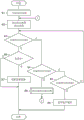
在服务器3中,控制部14若开始地图更新处理,则基于多个输入地图来生成统合地图(S1,相当于统合地图生成步骤)。控制部14若生成统合地图,则判定该生成的统合地图的可靠性(S2,相当于可靠性判定步骤)。控制部14若判定为该生成的统合地图的可靠性是高等级(S3:是),则判定被判定为该可靠性是高等级的统合地图与基准地图的差分的有无(S6)。控制部14若判定有差分(S6:是),则使差分反映于基准地图并更新差分,以更新基准地图(S7,相当于差分更新步骤),并结束地图更新处理。In the
控制部14若判定为该生成的统合地图的可靠性是中等级(S4:是),则移至统合地图更新处理(S8)。控制部14若开始统合地图更新处理,则基于存储于基准地图存储部16c的基准地图来设定区间(S11)。控制部14若设定区间,则将任意一个区间设定为作为差分判定的对象的差分判定对象区间(S12),并在包含探测数据的输入地图中生成每个区间的区间数据(S13)。控制部14若生成区间数据,则将该生成的区间数据作为积蓄数据存储于积蓄数据存储部16d(S14)。When the
控制部14根据积蓄数据的可靠性对存储于积蓄数据存储部16d的多个积蓄数据进行加权来估计道路形状数据(S15),并判定该估计出的道路形状数据的可靠性是否在规定等级以上(S16)。控制部14若判定为该估计出的道路形状数据的可靠性在规定等级以上(S16:是),则基于被判定为该可靠性在规定等级以上的道路形状数据来更新统合地图(S17),并结束统合地图更新处理,重回到地图更新处理。The
控制部14若判定为该估计出的道路形状数据的可靠性小于规定等级(S16:否),则将被判定为该可靠性小于规定等级的道路形状数据作为新的积蓄数据存储于积蓄数据存储部16d(S18),并结束统合地图更新处理,返回到地图更新处理。If the
控制部14若重回到地图更新处理,则返回到步骤S2,重复步骤S2以后,再次判定该更新后的统合地图的可靠性。即,控制部14通过对判定为可靠性是中等级的统合地图进行统合地图更新处理,若该可靠性从中等级上升至高等级,则判定该可靠性从中等级上升至高等级的统合地图与基准地图的差分的有无(S6),若判定有差分(S6:是),则使差分反映于基准地图并更新差分,以更新基准地图(S7)。另一方面,控制部14若对判定为可靠性是中等级的统合地图进行了统合地图更新处理,但该可靠性没有从中等级上升至高等级而继续中等级,则再次对该可靠性继续中等级的统合地图进行统合地图更新处理。另外,控制部14若判定为该生成的统合地图的可靠性是低等级(S5:是)则废弃被判定为该可靠性是低等级的统合地图(S9)。When returning to the map update process, the
以上,对估计表示以由多个坐标构成的坐标组表现的道路形状的道路形状数据作为形状数据的情况进行了说明,但也可以应用于估计表示以单一的坐标表现的地上物的形状的形状数据的情况。In the above, the case where the road shape data representing the shape of the road represented by a coordinate group composed of a plurality of coordinates is estimated is described as shape data, but it can also be applied to the shape estimated to represent the shape of a feature represented by a single coordinate. The condition of the data.
如以上说明那样,根据本实施方式,能够得到以下所示的作用效果。As described above, according to the present embodiment, the effects described below can be obtained.
在服务器3中,基于包含被赋予可靠性的探测数据的多个输入地图来生成统合地图,并判定该生成的统合地图的可靠性,若判定为统合地图的可靠性是高等级,则判定判定为该可靠性是高等级的统合地图与基准地图的差分的有无,若判定有差分,则使差分反映于基准地图并更新差分,以更新基准地图。通过将统合地图的可靠性为高等级设为更新基准地图的条件,能够适当地更新基准地图,能够适当地避免基准地图的精度的降低。In the
在服务器3中,若判定为统合地图的可靠性是中等级,则将判定为该可靠性是中等级的统合地图作为积蓄数据进行积蓄,并基于积蓄数据来更新统合地图。具体而言,基于基准地图来设定区间,在包含被赋予可靠性的探测数据的输入地图中生成每个区间的区间数据,并将该生成的区间数据作为积蓄数据进行存储。然后,根据积蓄数据的可靠性对针对同一区间的多个积蓄数据进行加权来估计道路形状数据。若判定为统合地图的可靠性是中等级,则基于积蓄数据来更新判定为该可靠性是中等级的统合地图,并根据积蓄数据的可靠性进行加权来估计道路形状数据,从而能够基于该估计出的道路形状数据来更新统合地图。In the
在服务器3中,判定道路形状数据的可靠性,若判定为道路形状数据的可靠性在规定等级以上,则基于判定为该可靠性在规定等级以上的道路形状数据来更新统合地图。通过将可靠性在规定等级以上设为基于道路形状数据来更新统合地图的条件,能够适当地提高统合地图的可靠性。In the
在服务器3中,将判定为可靠性小于规定等级的道路形状数据作为新的积蓄数据进行存储。通过将可靠性小于规定等级的道路形状数据作为新的积蓄数据进行存储,能够有效地活用可靠性小于规定等级的道路形状数据来估计道路形状数据。In the
在服务器3中,放弃判定为可靠性小于规定等级的道路形状数据。通过放弃可靠性小于规定等级的道路形状数据,能够降低存储积蓄数据所需要的存储容量。In the
在服务器3中,压缩相似的积蓄数据。通过压缩相似的积蓄数据,能够降低存储积蓄数据所需要的存储容量。In the
在服务器3中,管理积蓄数据的存储期间,并放弃存储期间达到规定期间以上的积蓄数据。通过放弃存储期间达到规定期间以上的积蓄数据,能够降低存储积蓄数据所需要的存储容量,并且能够防患使用新鲜度较低的积蓄数据来估计道路形状数据的情况于未然。The
在服务器3中,根据积蓄数据的可靠性对多个积蓄数据进行加权来估计道路形状数据。能够使用积蓄数据的可靠性来估计道路形状数据。在服务器3中,通过基于积蓄数据的可靠性的差对多个积蓄数据进行加权来估计道路形状数据,能够使用积蓄数据的可靠性的差来估计道路形状数据。在服务器3中,通过基于积蓄数据的可靠性的比率对多个积蓄数据进行加权来估计道路形状数据,能够使用积蓄数据的可靠性的比率来估计道路形状数据。在服务器3中,通过基于最高可靠性的积蓄数据对多个积蓄数据中的进行加权来估计道路形状数据,能够使用最高可靠性来估计道路形状数据。In the
在服务器3中,根据探测数据的可靠性对最近积蓄数据和过去积蓄数据进行加权来估计道路形状数据。通过使用最近积蓄数据来估计道路形状数据,能够估计新鲜度较高的道路形状数据。In the
本公开依据实施例进行了描述,但应该理解并不限定于该实施例、结构。本公开也包含各种变形例、同等范围内的变形。除此之外,各种组合、方式、以及在它们中包含仅一个要素,其以上,或者其以下的其它组合、方式也在本公开的范畴、思想范围内。Although the present disclosure has been described based on the examples, it should not be understood that it is not limited to the examples and configurations. This disclosure also includes various modified examples and modifications within the equivalent range. In addition, various combinations, forms, and other combinations and forms including only one element among them, above or below, are also within the scope and scope of the present disclosure.
本公开所记载的控制部及其方法也可以由通过构成被编程为执行通过计算机程序具体化的一个或者多个功能的处理器以及存储器提供的专用计算机来实现。或者,本公开所记载的控制部及其方法也可以由通过由一个以上的专用硬件逻辑电路构成处理器提供的专用计算机来实现。或者,本公开所记载的控制部及其方法也可以由通过被编程为执行一个或者多个功能的处理器以及存储器与由一个以上的硬件逻辑电路构成的处理器的组合构成的一个以上的专用计算机来实现。另外,计算机程序也可以作为由计算机执行的指令,存储于计算机能够读取的非迁移有形记录介质。The control unit and the method thereof described in the present disclosure may also be realized by a dedicated computer provided by a processor configured to execute one or more functions embodied by a computer program, and a memory. Alternatively, the control unit and the method thereof described in the present disclosure may also be realized by a dedicated computer provided by a processor constituted by one or more dedicated hardware logic circuits. Alternatively, the control unit and the method thereof described in the present disclosure may also be composed of one or more special-purpose processors programmed to perform one or more functions and a combination of memory and processors composed of one or more hardware logic circuits. computer to achieve. In addition, the computer program may be stored in a computer-readable non-transferable tangible recording medium as instructions executed by a computer.
在服务器3中,例示出不将未包含规定个数以上的探测数据的段、未包含规定个数以上的检测等级在规定等级以上的探测数据的段作为获取对象的结构,但在车载机2中,也可以设定将探测数据发送给服务器3的条件。即,在车载机2中,例示出例如每当经过规定时间或者每当车辆的行驶距离达到规定距离则向服务器3发送探测数据的结构,但也可以构成为判定段所包含的探测数据的检测数,仅在探测数据的检测数在规定个数以上的情况下向服务器3发送探测数据。即,例如也有由于先行车辆的存在等而探测数据的检测数不在规定个数以上的情况,在假定即使将探测数据的检测数不在规定个数以上的段所包含的探测数据发送到服务器3,服务器3也不将该探测数据作为处理对象而放弃的情况下,也可以构成为不将该探测数据发送到服务器3。通过不从车载机2发送对于服务器3来说不需要的探测数据,从而能够降低数据通信的负荷。In the
Claims (12)
Applications Claiming Priority (3)
| Application Number | Priority Date | Filing Date | Title |
|---|---|---|---|
| JP2020119191 | 2020-07-10 | ||
| JP2020-119191 | 2020-07-10 | ||
| PCT/JP2021/022689 WO2022009625A1 (en) | 2020-07-10 | 2021-06-15 | Map update device and map update program |
Publications (1)
| Publication Number | Publication Date |
|---|---|
| CN115777123A true CN115777123A (en) | 2023-03-10 |
Family
ID=79552935
Family Applications (1)
| Application Number | Title | Priority Date | Filing Date |
|---|---|---|---|
| CN202180048463.3A Withdrawn CN115777123A (en) | 2020-07-10 | 2021-06-15 | Map update device and map update program |
Country Status (5)
| Country | Link |
|---|---|
| US (1) | US12306012B2 (en) |
| JP (1) | JP7327674B2 (en) |
| CN (1) | CN115777123A (en) |
| DE (1) | DE112021003686T5 (en) |
| WO (1) | WO2022009625A1 (en) |
Families Citing this family (1)
| Publication number | Priority date | Publication date | Assignee | Title |
|---|---|---|---|---|
| JP7701401B2 (en) * | 2023-04-21 | 2025-07-01 | ウーブン・バイ・トヨタ株式会社 | Map update device, map update method, and computer program for updating map |
Citations (1)
| Publication number | Priority date | Publication date | Assignee | Title |
|---|---|---|---|---|
| CN102341836A (en) * | 2009-03-04 | 2012-02-01 | 三菱电机株式会社 | Map distribution server, map information terminal, and map distribution system using these map distribution server and map information terminal |
Family Cites Families (9)
| Publication number | Priority date | Publication date | Assignee | Title |
|---|---|---|---|---|
| JP2002318532A (en) | 2002-01-29 | 2002-10-31 | Matsushita Electric Ind Co Ltd | Map editing display |
| JP4718396B2 (en) | 2006-08-24 | 2011-07-06 | 日立オートモティブシステムズ株式会社 | Landmark recognition system |
| JP5064870B2 (en) | 2007-04-17 | 2012-10-31 | 株式会社日立製作所 | Digital road map generation method and map generation system |
| JP5499497B2 (en) | 2009-03-10 | 2014-05-21 | 株式会社デンソー | Road map data management system |
| CN112923936B (en) | 2015-02-10 | 2023-04-18 | 御眼视觉技术有限公司 | Navigation system, method, and computer readable medium for vehicle |
| JP7063310B2 (en) * | 2018-08-31 | 2022-05-09 | 株式会社デンソー | Map generation system, in-vehicle device |
| JP6958535B2 (en) | 2018-12-07 | 2021-11-02 | 株式会社デンソー | Probe data evaluation device, probe data evaluation program |
| JP7248948B2 (en) | 2019-01-23 | 2023-03-30 | 富士電機株式会社 | vending machine |
| DE112020002630T5 (en) * | 2019-05-29 | 2022-03-10 | Denso Corporation | MAP SYSTEM, MAP GENERATION PROGRAM, STORAGE MEDIUM, IN-VEHICLE DEVICE AND SERVER |
-
2021
- 2021-06-15 CN CN202180048463.3A patent/CN115777123A/en not_active Withdrawn
- 2021-06-15 JP JP2022534985A patent/JP7327674B2/en active Active
- 2021-06-15 DE DE112021003686.6T patent/DE112021003686T5/en active Pending
- 2021-06-15 WO PCT/JP2021/022689 patent/WO2022009625A1/en not_active Ceased
-
2022
- 2022-12-28 US US18/147,310 patent/US12306012B2/en active Active
Patent Citations (1)
| Publication number | Priority date | Publication date | Assignee | Title |
|---|---|---|---|---|
| CN102341836A (en) * | 2009-03-04 | 2012-02-01 | 三菱电机株式会社 | Map distribution server, map information terminal, and map distribution system using these map distribution server and map information terminal |
Also Published As
| Publication number | Publication date |
|---|---|
| WO2022009625A1 (en) | 2022-01-13 |
| JPWO2022009625A1 (en) | 2022-01-13 |
| DE112021003686T5 (en) | 2023-06-01 |
| US12306012B2 (en) | 2025-05-20 |
| JP7327674B2 (en) | 2023-08-16 |
| US20230128627A1 (en) | 2023-04-27 |
Similar Documents
| Publication | Publication Date | Title |
|---|---|---|
| US20230079730A1 (en) | Control device, scanning system, control method, and program | |
| JP6325806B2 (en) | Vehicle position estimation system | |
| US20180165525A1 (en) | Traveling lane determining device and traveling lane determining method | |
| US12313428B2 (en) | Position estimation method, position estimation device, and position estimation program | |
| CN113706586B (en) | Target tracking method and device based on multi-point position perception and storage medium | |
| JP2016156973A (en) | Map data storage device, control method, program and recording medium | |
| WO2018180338A1 (en) | Information processing device, server device, control method, program, and storage medium | |
| US11977159B2 (en) | Method for determining a position of a vehicle | |
| JP7659617B2 (en) | IMAGE RECOGNITION DEVICE AND IMAGE RECOGNITION METHOD | |
| US12460942B2 (en) | Map system, map generating program, storage medium, on-vehicle apparatus, and server | |
| JP7603541B2 (en) | Driving assistance device and driving assistance method | |
| JP7808722B2 (en) | Information processing device, map data generation device, method, and program | |
| JP5974923B2 (en) | Road edge detection system, method and program | |
| JP5888275B2 (en) | Road edge detection system, method and program | |
| CN115777123A (en) | Map update device and map update program | |
| US12228421B2 (en) | Map update device and storage medium | |
| WO2019220765A1 (en) | Self-position estimation device | |
| JP7120170B2 (en) | Lane estimation device | |
| WO2018221458A1 (en) | Updating device, control method, program, and storage medium | |
| KR102091555B1 (en) | System for estimating arrival time by route of vechicle | |
| US20240142258A1 (en) | Object detection device, object detection method, and storage medium storing program | |
| JP7742802B2 (en) | Inter-vehicle distance estimation device | |
| JP7474689B2 (en) | Object detection method and object detection device | |
| CN111971579A (en) | Object identification device |
Legal Events
| Date | Code | Title | Description |
|---|---|---|---|
| PB01 | Publication | ||
| PB01 | Publication | ||
| SE01 | Entry into force of request for substantive examination | ||
| SE01 | Entry into force of request for substantive examination | ||
| WW01 | Invention patent application withdrawn after publication | ||
| WW01 | Invention patent application withdrawn after publication |
Application publication date: 20230310 |