CN115334167B - An Angle Threshold Adaptive Trajectory Compression Method - Google Patents
An Angle Threshold Adaptive Trajectory Compression Method Download PDFInfo
- Publication number
- CN115334167B CN115334167B CN202210771945.8A CN202210771945A CN115334167B CN 115334167 B CN115334167 B CN 115334167B CN 202210771945 A CN202210771945 A CN 202210771945A CN 115334167 B CN115334167 B CN 115334167B
- Authority
- CN
- China
- Prior art keywords
- track
- data
- point
- trajectory
- target
- Prior art date
- Legal status (The legal status is an assumption and is not a legal conclusion. Google has not performed a legal analysis and makes no representation as to the accuracy of the status listed.)
- Expired - Fee Related
Links
Images


Classifications
-
- H—ELECTRICITY
- H04—ELECTRIC COMMUNICATION TECHNIQUE
- H04L—TRANSMISSION OF DIGITAL INFORMATION, e.g. TELEGRAPHIC COMMUNICATION
- H04L69/00—Network arrangements, protocols or services independent of the application payload and not provided for in the other groups of this subclass
- H04L69/04—Protocols for data compression, e.g. ROHC
-
- G—PHYSICS
- G01—MEASURING; TESTING
- G01C—MEASURING DISTANCES, LEVELS OR BEARINGS; SURVEYING; NAVIGATION; GYROSCOPIC INSTRUMENTS; PHOTOGRAMMETRY OR VIDEOGRAMMETRY
- G01C21/00—Navigation; Navigational instruments not provided for in groups G01C1/00 - G01C19/00
- G01C21/26—Navigation; Navigational instruments not provided for in groups G01C1/00 - G01C19/00 specially adapted for navigation in a road network
- G01C21/28—Navigation; Navigational instruments not provided for in groups G01C1/00 - G01C19/00 specially adapted for navigation in a road network with correlation of data from several navigational instruments
- G01C21/30—Map- or contour-matching
-
- H—ELECTRICITY
- H04—ELECTRIC COMMUNICATION TECHNIQUE
- H04L—TRANSMISSION OF DIGITAL INFORMATION, e.g. TELEGRAPHIC COMMUNICATION
- H04L67/00—Network arrangements or protocols for supporting network services or applications
- H04L67/01—Protocols
- H04L67/12—Protocols specially adapted for proprietary or special-purpose networking environments, e.g. medical networks, sensor networks, networks in vehicles or remote metering networks
-
- Y—GENERAL TAGGING OF NEW TECHNOLOGICAL DEVELOPMENTS; GENERAL TAGGING OF CROSS-SECTIONAL TECHNOLOGIES SPANNING OVER SEVERAL SECTIONS OF THE IPC; TECHNICAL SUBJECTS COVERED BY FORMER USPC CROSS-REFERENCE ART COLLECTIONS [XRACs] AND DIGESTS
- Y02—TECHNOLOGIES OR APPLICATIONS FOR MITIGATION OR ADAPTATION AGAINST CLIMATE CHANGE
- Y02T—CLIMATE CHANGE MITIGATION TECHNOLOGIES RELATED TO TRANSPORTATION
- Y02T10/00—Road transport of goods or passengers
- Y02T10/10—Internal combustion engine [ICE] based vehicles
- Y02T10/40—Engine management systems
Landscapes
- Engineering & Computer Science (AREA)
- Radar, Positioning & Navigation (AREA)
- Remote Sensing (AREA)
- Signal Processing (AREA)
- Computer Networks & Wireless Communication (AREA)
- Medical Informatics (AREA)
- Health & Medical Sciences (AREA)
- Computer Security & Cryptography (AREA)
- General Health & Medical Sciences (AREA)
- Computing Systems (AREA)
- Automation & Control Theory (AREA)
- Physics & Mathematics (AREA)
- General Physics & Mathematics (AREA)
- Instructional Devices (AREA)
- Traffic Control Systems (AREA)
Abstract
本发明公开了一种角度阈值自适应的轨迹压缩方法,涉及数据压缩技术领域。获取矢量地图数据提取原始道路数据并进行网格划分,得到包含多个网格区域的目标道路数据;对目标道路数据进行网络拓扑分析,统计网格区域内所包含的道路交点数目分配角度阈值;计算原始行驶轨迹中各个轨迹点的偏转角度值,将满足预设条件的轨迹点存入缓存队列,得到缓存行驶轨迹;计算缓存行驶轨迹中各个轨迹点的偏转累积值,根据偏转累积值进行采样和存储,得到目标车辆压缩后的目标行驶轨迹。通过上述方法可以有效地对轨迹数据进行压缩,同时有效地保留车辆转弯的轨迹数据,并根据偏转角度值和偏转累积值进行两次数据压缩,减小轨迹数据量。

The invention discloses an angle threshold adaptive trajectory compression method, which relates to the technical field of data compression. Obtain vector map data to extract the original road data and perform grid division to obtain target road data containing multiple grid areas; perform network topology analysis on the target road data, count the number of road intersections contained in the grid area and assign angle thresholds; Calculate the deflection angle value of each track point in the original driving track, store the track points that meet the preset conditions in the cache queue, and obtain the cached driving track; calculate the deflection cumulative value of each track point in the cached driving track, and sample according to the deflection cumulative value and storage to obtain the compressed target driving trajectory of the target vehicle. The above method can effectively compress the trajectory data, and at the same time effectively retain the trajectory data of the vehicle turning, and perform two data compressions according to the deflection angle value and the deflection cumulative value to reduce the amount of trajectory data.
Description
技术领域Technical Field
本发明涉及数据压缩技术领域,具体涉及一种角度阈值自适应的轨迹压缩方法。The invention relates to the technical field of data compression, and in particular to an angle threshold adaptive trajectory compression method.
背景技术Background Art
轨迹数据包含了在一定的时空环境下,一个或者多个移动对象其运动过程中所产生的位置信息、时间信息、速度信息等,这些信息按照时间序列进行排序即构成了移动对象的运动轨迹。例如应用在智能手机上的定位系统可以通过GPS信号或基站信号定位手机所处位置信息进行收集和采样,车辆可以通过车载的定位系统对车辆行驶过程中的轨迹点进行持续采集。这些采集到的轨迹数据按时间排序即可绘制出运动对象在一段时间内的运动轨迹数据,其中包含了丰富的语义信息等。Trajectory data includes the location information, time information, speed information, etc. generated by one or more moving objects during their movement in a certain space-time environment. This information is sorted in time series to form the movement trajectory of the moving object. For example, the positioning system used in smart phones can collect and sample the location information of the mobile phone through GPS signals or base station signals, and the vehicle can continuously collect trajectory points during the vehicle's driving process through the on-board positioning system. These collected trajectory data can be sorted by time to draw the movement trajectory data of the moving object over a period of time, which contains rich semantic information.
随着5G与物联网的发展,配备存储硬件的GPS在各类车辆上得到了广泛使用,因此也产生了海量的轨迹数据。这些应用方便了车辆的位置跟踪、预测和分析,同时也随着轨迹数据重要性的增强,定位设备采集轨迹点的频率也在不断地提高,它们以秒级的速率采集位置信息,这导致了轨迹数据量大、传输与存储代价高昂、数据存在冗余等问题。With the development of 5G and the Internet of Things, GPS equipped with storage hardware has been widely used in various vehicles, thus generating a massive amount of trajectory data. These applications facilitate the tracking, prediction and analysis of vehicle locations. At the same time, as the importance of trajectory data increases, the frequency of tracking points collected by positioning devices is also increasing. They collect location information at a rate of seconds, which leads to problems such as large amounts of trajectory data, high transmission and storage costs, and data redundancy.
发明内容Summary of the invention
本发明的目的就在于解决上述背景技术的问题,而提出一种角度阈值自适应的轨迹压缩方法。The purpose of the present invention is to solve the above-mentioned problems in the background technology and to propose a trajectory compression method with adaptive angle threshold.
本发明的目的可以通过以下技术方案实现:The purpose of the present invention can be achieved through the following technical solutions:
本发明实施例提供了一种角度阈值自适应的轨迹压缩方法,所述方法包括:An embodiment of the present invention provides a trajectory compression method with an angle threshold self-adaptation, the method comprising:
在预设地图库内获取目标车辆当前行驶区域的矢量地图数据,从所述矢量地图数据中提取原始道路数据并进行网格划分,得到包含多个网格区域的目标道路数据;Obtaining vector map data of the current driving area of the target vehicle in a preset map library, extracting original road data from the vector map data and performing grid division to obtain target road data including a plurality of grid areas;
对所述目标道路数据进行网络拓扑分析,针对每一网格区域,统计该网格区域内所包含的道路交点数目,为该网格区域分配角度阈值;Performing a network topology analysis on the target road data, counting the number of road intersections contained in each grid area, and assigning an angle threshold to the grid area;
在所述目标车辆的原始行驶轨迹采集过程中,计算所述原始行驶轨迹中各个轨迹点的偏转角度值,根据各个轨迹点的位置和偏转角度值,将满足预设条件的轨迹点存入缓存队列,得到缓存行驶轨迹;During the acquisition of the original driving trajectory of the target vehicle, the deflection angle value of each trajectory point in the original driving trajectory is calculated, and according to the position and deflection angle value of each trajectory point, the trajectory points that meet the preset conditions are stored in a cache queue to obtain a cached driving trajectory;
计算所述缓存行驶轨迹中各个轨迹点的偏转累积值,根据所述偏转累积值进行采样和存储,得到所述目标车辆压缩后的目标行驶轨迹。The deflection accumulation value of each track point in the cached driving track is calculated, and sampling and storage are performed according to the deflection accumulation value to obtain the compressed target driving track of the target vehicle.
可选地,在预设地图库内获取目标车辆当前行驶区域的矢量地图数据,从所述矢量地图数据中提取原始道路数据并进行网格划分,得到包含多个网格区域的目标道路数据,包括:Optionally, vector map data of the current driving area of the target vehicle is obtained in a preset map library, original road data is extracted from the vector map data and gridded to obtain target road data containing multiple grid areas, including:
使用开源地图OSM地图数据库,获取目标车辆当前行驶城市或行驶区域的矢量地图数据,修改所述矢量地图数据的编码格式为UTF-8编码格式,得到矢量道路数据;Using the open source map OSM map database, obtaining vector map data of the city or area where the target vehicle is currently traveling, modifying the encoding format of the vector map data to the UTF-8 encoding format, and obtaining vector road data;
选取矢量道路数据中的矢量线数据,并根据预设字段属性选取矢量线数据,导出为OSM格式的原始道路数据;Select vector line data from vector road data, select vector line data according to preset field attributes, and export them to original road data in OSM format;
对所述原始道路数据进行栅格化处理,根据所述原始道路数据的图层大小新建栅格,在像元高度和宽度处将矢量地图按照预设尺寸进行网格划分,得到包含多个网格区域的目标道路数据。The original road data is rasterized, a new grid is created according to the layer size of the original road data, and the vector map is gridded according to a preset size at the pixel height and width to obtain target road data containing multiple grid areas.
可选地,所述原始道路数据包括字段属性为primary、secondary、tertiary、motoway、service的矢量线数据中的至少一种。Optionally, the original road data includes at least one of vector line data with field attributes of primary, secondary, tertiary, motoway, and service.
可选地,对所述目标道路数据进行网络拓扑分析,针对每一网格区域,统计该网格区域内所包含的道路交点数目,为该网格区域分配角度阈值,包括:Optionally, a network topology analysis is performed on the target road data, and for each grid area, the number of road intersections contained in the grid area is counted, and an angle threshold is allocated to the grid area, including:
新建所述目标车辆的个人地理数据库,在所述个人地理数据库中建立要素数据集并将所述目标道路数据导入,使用所述要素数据集新建拓扑规则,根据所述拓扑规则去除所述目标道路数据中的悬挂点和重叠数据,得到中间目标道路数据;Create a personal geographic database for the target vehicle, create a feature dataset in the personal geographic database and import the target road data, create a topology rule using the feature dataset, remove hanging points and overlapping data in the target road data according to the topology rule, and obtain intermediate target road data;
使用所述中间目标道路数据建立新的道路数据集得到道路交点数据,针对每一网格区域,根据道路交点数据所在的网格字段的不同,统计该网格区域内所包含的道路交点数目;Using the intermediate target road data to establish a new road data set to obtain road intersection data, for each grid area, according to the different grid fields where the road intersection data is located, counting the number of road intersections contained in the grid area;
针对每一网格区域,计算该网格区域的角度阈值:For each grid area, calculate the angle threshold of the grid area:

其中,βi为第i个网格区域的角度阈值,ci为第i个网格区域中所包含的道路交点数目,
可选地,在所述目标车辆的原始行驶轨迹采集过程中,计算所述原始行驶轨迹中各个轨迹点的偏转角度值,根据各个轨迹点的位置和偏转角度值,将满足预设条件的轨迹点存入缓存队列,得到缓存行驶轨迹,包括:Optionally, during the original driving trajectory acquisition process of the target vehicle, the deflection angle value of each trajectory point in the original driving trajectory is calculated, and according to the position and deflection angle value of each trajectory point, the trajectory points that meet the preset conditions are stored in a cache queue to obtain a cache driving trajectory, including:
对所述目标车辆的行驶轨迹数据以预设频率进行采集,得到原始行驶轨迹;The driving trajectory data of the target vehicle is collected at a preset frequency to obtain an original driving trajectory;
针对所述原始行驶轨迹的每一轨迹点,若该轨迹点为所述原始行驶轨迹的起始轨迹点或者结束轨迹点,则将该轨迹点加入到缓存队列中进行缓存;For each trajectory point of the original driving trajectory, if the trajectory point is a starting trajectory point or an ending trajectory point of the original driving trajectory, the trajectory point is added to a cache queue for caching;
针对所述原始行驶轨迹的每一轨迹点,若该轨迹点为所述原始行驶轨迹的中间轨迹点,则计算该中间轨迹点的偏转角度值;For each trajectory point of the original driving trajectory, if the trajectory point is an intermediate trajectory point of the original driving trajectory, calculating the deflection angle value of the intermediate trajectory point;
针对每一中间轨迹点,将该中间轨迹点的偏转角度值与该中间轨迹点所在网格区域对应的角度阈值进行对比,若满足偏转角度值大于角度阈值,则将该中间轨迹点选取为候选点并加入到缓存队列中进行缓存,得到缓存行驶轨迹,否则,将该中间轨迹点暂时保留,在计算完下一个中间轨迹点的角度偏转角度值后丢弃;For each intermediate track point, the deflection angle value of the intermediate track point is compared with the angle threshold corresponding to the grid area where the intermediate track point is located. If the deflection angle value is greater than the angle threshold, the intermediate track point is selected as a candidate point and added to the cache queue for caching to obtain a cached driving trajectory. Otherwise, the intermediate track point is temporarily retained and discarded after calculating the angle deflection angle value of the next intermediate track point.
针对所述原始行驶轨迹的每一轨迹点,若该轨迹点为所述原始行驶轨迹的结束轨迹点,则获取缓存队列中保存的轨迹点,组合得到缓存行驶轨迹。For each trajectory point of the original driving trajectory, if the trajectory point is the end trajectory point of the original driving trajectory, the trajectory points stored in the cache queue are obtained and combined to obtain a cache driving trajectory.
可选地,计算该中间轨迹点的偏转角度值,包括:Optionally, calculating the deflection angle value of the intermediate trajectory point includes:
计算该中间轨迹点Pcur与其前一个轨迹点Ppre和后一个轨迹点Pfol为顶点构成的三角形的边长:Calculate the side length of the triangle formed by the intermediate trajectory point P cur and its previous trajectory point P pre and the next trajectory point P fol as vertices:


其中,

计算Pcur与Ppre和Pfol之间的距离:Calculate the distance between P cur and P pre and P fol :


其中,l1代表Ppre和Pcur的距离;l2代表Pfol和Pcur的距离;l3代表Ppre和Pfol的距离;R代表地球的平均半径,取R=6371.004km;Among them, l 1 represents the distance between P pre and P cur ; l 2 represents the distance between P fol and P cur ; l 3 represents the distance between P pre and P fol ; R represents the average radius of the earth, R = 6371.004 km;
计算Pcur的偏转角度值θk:Calculate the deflection angle θ k of P cur :

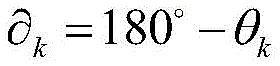
可选地,计算所述缓存行驶轨迹中各个轨迹点的偏转累积值,根据所述偏转累积值进行采样和存储,得到所述目标车辆压缩后的目标行驶轨迹,包括:Optionally, calculating the deflection cumulative value of each track point in the cached driving track, sampling and storing according to the deflection cumulative value, and obtaining the compressed target driving track of the target vehicle, comprises:
针对所述缓存行驶轨迹中的每一轨迹点,计算偏转角度值与平角的差值:For each track point in the cached driving track, the difference between the deflection angle value and the straight angle is calculated:

其中,
将连续的N个轨迹点的角度差值进行计算并累加:Calculate and accumulate the angle differences of N consecutive trajectory points:

根据N值确定角度累积阈值


本发明实施例提供了一种角度阈值自适应的轨迹压缩方法,在预设地图库内获取目标车辆当前行驶区域的矢量地图数据,从矢量地图数据中提取原始道路数据并进行网格划分,得到包含多个网格区域的目标道路数据;对目标道路数据进行网络拓扑分析,针对每一网格区域,统计该网格区域内所包含的道路交点数目,为该网格区域分配角度阈值;在目标车辆的原始行驶轨迹采集过程中,计算原始行驶轨迹中各个轨迹点的偏转角度值,根据各个轨迹点的位置和偏转角度值,将满足预设条件的轨迹点存入缓存队列,得到缓存行驶轨迹;计算缓存行驶轨迹中各个轨迹点的偏转累积值,根据偏转累积值进行采样和存储,得到目标车辆压缩后的目标行驶轨迹。通过目标车辆行驶网格区域的道路交点的密集程度动态分配角度阈值,在道路交点数目较小的区域车辆转弯的概率相对偏小,采用更大的角度阈值可以有效地对轨迹数据进行压缩,同时对道路交点数目较多地区域采用较小的角度阈值,可以有效地保留车辆转弯的轨迹数据,保留车辆行驶中的特征轨迹点,并根据偏转角度值和偏转累积值进行两次数据压缩,减小轨迹数据量,解决了传输与存储代价高昂、数据存在冗余等问题。The embodiment of the present invention provides a trajectory compression method with adaptive angle threshold, which obtains vector map data of the current driving area of a target vehicle in a preset map library, extracts original road data from the vector map data and performs grid division to obtain target road data containing multiple grid areas; performs network topology analysis on the target road data, and for each grid area, counts the number of road intersections contained in the grid area, and allocates an angle threshold to the grid area; in the process of collecting the original driving trajectory of the target vehicle, calculates the deflection angle value of each trajectory point in the original driving trajectory, stores the trajectory points that meet the preset conditions into a cache queue according to the position and deflection angle value of each trajectory point, and obtains a cached driving trajectory; calculates the deflection cumulative value of each trajectory point in the cached driving trajectory, samples and stores according to the deflection cumulative value, and obtains the compressed target driving trajectory of the target vehicle. The angle threshold is dynamically allocated according to the density of road intersections in the target vehicle driving grid area. In areas with a small number of road intersections, the probability of vehicle turning is relatively small. Using a larger angle threshold can effectively compress the trajectory data. At the same time, using a smaller angle threshold in areas with a large number of road intersections can effectively retain the trajectory data of vehicle turns and the characteristic trajectory points of the vehicle during driving. Data compression is performed twice according to the deflection angle value and the deflection cumulative value to reduce the amount of trajectory data and solve the problems of high transmission and storage costs and data redundancy.
附图说明BRIEF DESCRIPTION OF THE DRAWINGS
下面结合附图对本发明作进一步的说明。The present invention will be further described below in conjunction with the accompanying drawings.
图1为本发明实施例提供的一种角度阈值自适应的轨迹压缩方法的流程图;FIG1 is a flow chart of a trajectory compression method with adaptive angle threshold provided by an embodiment of the present invention;
图2为本发明实施例提供的另一种角度阈值自适应的轨迹压缩方法的流程图;FIG2 is a flow chart of another angle threshold adaptive trajectory compression method provided by an embodiment of the present invention;
图3为本发明实施例提供的轨迹压缩方法和基于DP改进的轨迹压缩方法的仿真图;FIG3 is a simulation diagram of a trajectory compression method provided by an embodiment of the present invention and a trajectory compression method improved based on DP;
图4为本发明实施例提供的轨迹压缩方法和不引入缓存队列的轨迹压缩方法的仿真图。FIG. 4 is a simulation diagram of a trajectory compression method provided by an embodiment of the present invention and a trajectory compression method without introducing a cache queue.
具体实施方式DETAILED DESCRIPTION
下面将结合本发明实施例中的附图,对本发明实施例中的技术方案进行清楚、完整地描述,显然,所描述的实施例仅仅是本发明一部分实施例,而不是全部的实施例。基于本发明中的实施例,本领域普通技术人员在没有作出创造性劳动前提下所获得的所有其它实施例,都属于本发明保护的范围。The following will be combined with the drawings in the embodiments of the present invention to clearly and completely describe the technical solutions in the embodiments of the present invention. Obviously, the described embodiments are only part of the embodiments of the present invention, not all of the embodiments. Based on the embodiments of the present invention, all other embodiments obtained by ordinary technicians in this field without creative work are within the scope of protection of the present invention.
本发明实施例提供了一种角度阈值自适应的轨迹压缩方法。参见图1,图1为本发明实施例提供的一种角度阈值自适应的轨迹压缩方法的流程图。该方法可以包括以下步骤:The embodiment of the present invention provides a trajectory compression method with an angle threshold adaptive. Referring to FIG1 , FIG1 is a flow chart of a trajectory compression method with an angle threshold adaptive provided by an embodiment of the present invention. The method may include the following steps:
S101,在预设地图库内获取目标车辆当前行驶区域的矢量地图数据,从矢量地图数据中提取原始道路数据并进行网格划分,得到包含多个网格区域的目标道路数据。S101, obtaining vector map data of a current driving area of a target vehicle in a preset map library, extracting original road data from the vector map data and performing grid division to obtain target road data including a plurality of grid areas.
S102,对目标道路数据进行网络拓扑分析,针对每一网格区域,统计该网格区域内所包含的道路交点数目,为该网格区域分配角度阈值。S102, performing network topology analysis on the target road data, counting the number of road intersections contained in each grid area, and assigning an angle threshold to the grid area.
S103,在目标车辆的原始行驶轨迹采集过程中,计算原始行驶轨迹中各个轨迹点的偏转角度值,根据各个轨迹点的位置和偏转角度值,将满足预设条件的轨迹点存入缓存队列,得到缓存行驶轨迹。S103, during the collection of the original driving trajectory of the target vehicle, the deflection angle value of each trajectory point in the original driving trajectory is calculated, and according to the position and deflection angle value of each trajectory point, the trajectory points that meet the preset conditions are stored in a cache queue to obtain a cached driving trajectory.
S104,计算缓存行驶轨迹中各个轨迹点的偏转累积值,根据偏转累积值进行采样和存储,得到目标车辆压缩后的目标行驶轨迹。S104, calculating the deflection cumulative value of each track point in the cached driving track, sampling and storing according to the deflection cumulative value, and obtaining a compressed target driving track of the target vehicle.
基于本发明实施例提供的一种角度阈值自适应的轨迹压缩方法,通过目标车辆行驶网格区域的道路交点的密集程度动态分配角度阈值,在道路交点数目较小的区域车辆转弯的概率相对偏小,采用更大的角度阈值可以有效地对轨迹数据进行压缩,同时对道路交点数目较多地区域采用较小的角度阈值,可以有效地保留车辆转弯的轨迹数据,保留车辆行驶中的特征轨迹点,并根据偏转角度值和偏转累积值进行两次数据压缩,减小轨迹数据量,解决了传输与存储代价高昂、数据存在冗余等问题。An angle threshold adaptive trajectory compression method provided by an embodiment of the present invention dynamically allocates an angle threshold according to the density of road intersections in a target vehicle driving grid area. In an area with a small number of road intersections, the probability of a vehicle turning is relatively small. A larger angle threshold can be used to effectively compress trajectory data. At the same time, a smaller angle threshold is used for an area with a large number of road intersections, which can effectively retain the trajectory data of vehicle turns and the characteristic trajectory points of the vehicle during driving. The data is compressed twice according to the deflection angle value and the deflection cumulative value, thereby reducing the amount of trajectory data and solving the problems of high transmission and storage costs and data redundancy.
一种实现方式中,预设地图库可以使用自行开发的地图库,或者,使用现有的开源地图库。In one implementation, the preset map library may use a self-developed map library, or use an existing open source map library.
一种实现方式中,当前网格区域道路交点的密集程度,决定了在网格区域内车辆可能转弯行驶的概率,在道路交点数目较小的区域车辆转弯的概率相对偏小,其连续的N个采样点形成的轨迹更可能趋于直线,可以为该网格区域分配更大的角度阈值,进而可以减少该网格区域内缓存行驶轨迹中的轨迹点,最终减小目标行驶轨迹的数据量。同时对道路交点数目较多的网格区域,在该网格区域内车辆转弯行驶的概率更大,采用较小的角度阈值,可以有效地保留车辆转弯的轨迹数据,保留车辆行驶中的特征轨迹点。In one implementation, the density of the road intersections in the current grid area determines the probability that the vehicle may turn in the grid area. In areas with a small number of road intersections, the probability of a vehicle turning is relatively small, and the trajectory formed by its N consecutive sampling points is more likely to be a straight line. A larger angle threshold can be assigned to the grid area, thereby reducing the number of trajectory points in the cached driving trajectory in the grid area, and ultimately reducing the amount of data on the target driving trajectory. At the same time, for grid areas with a large number of road intersections, the probability of a vehicle turning in the grid area is greater. Using a smaller angle threshold can effectively retain the trajectory data of the vehicle turning and retain the characteristic trajectory points of the vehicle during driving.
一种实现方式中,在对数据压缩过程中,一次仅需要对缓存队列中的缓存行驶轨迹进行处理,可以满足实时采集并压缩的需求,实现对轨迹的在线压缩,减小目标行驶轨迹的传输和存储压力。In one implementation, during the data compression process, only the cached driving trajectories in the cache queue need to be processed at a time, which can meet the needs of real-time collection and compression, realize online compression of the trajectory, and reduce the transmission and storage pressure of the target driving trajectory.
在一个实施例中,步骤S101包括以下步骤:In one embodiment, step S101 includes the following steps:
步骤一,使用开源地图OSM地图数据库,获取目标车辆当前行驶城市或行驶区域的矢量地图数据,修改矢量地图数据矢量地图数据矢量地图数据矢量地图数据的编码格式为UTF-8编码格式,得到矢量道路数据。Step 1: Use the open source map OSM map database to obtain the vector map data of the city or area where the target vehicle is currently traveling, modify the encoding format of the vector map data to the UTF-8 encoding format, and obtain the vector road data.
步骤二,选取矢量道路数据中的矢量线数据,并根据预设字段属性选取矢量线数据,导出为OSM格式的原始道路数据。Step 2: Select the vector line data in the vector road data, and select the vector line data according to the preset field attributes, and export it as the original road data in OSM format.
步骤三,对原始道路数据进行栅格化处理,根据原始道路数据的图层大小新建栅格,在像元高度和宽度处将矢量地图按照预设尺寸进行网格划分,得到包含多个网格区域的目标道路数据。Step three, rasterize the original road data, create a new raster according to the layer size of the original road data, divide the vector map into grids according to the preset size at the pixel height and width, and obtain the target road data containing multiple grid areas.
一种实现方式中,可以将矢量地图数据导入QGIS软件,在属性-源数据中修改矢量地图数据的编码格式为UTF-8编码格式,得到矢量道路数据。In one implementation, the vector map data may be imported into QGIS software, and the encoding format of the vector map data may be modified to UTF-8 encoding format in Properties-Source Data to obtain vector road data.
一种实现方式中,可以使用ARCGIS程序中的数据导出工具,可以在矢量道路数据中导出矢量线数据。In one implementation, a data export tool in an ARCGIS program may be used to export vector line data from vector road data.
一种实现方式中,可以使用ARCGIS程序对提取到的原始道路数据进行栅格化处理,使用数据管理工具中的渔网工具,根据道路数据的图层大小新建栅格,在像元高度和宽度处将矢量地图按照预设尺寸进行网格划分,即可得到包含多个网格区域的目标道路数据。预设尺寸可以由技术人员根据实际情况进行设置,在此不作限定,例如,预设尺寸可以为500m×500m,或者预设尺寸可以为100m×100m等等。In one implementation, the extracted original road data can be rasterized using the ARCGIS program, and the fishnet tool in the data management tool can be used to create a new grid according to the layer size of the road data, and the vector map can be gridded according to the preset size at the pixel height and width to obtain the target road data containing multiple grid areas. The preset size can be set by the technician according to the actual situation and is not limited here. For example, the preset size can be 500m×500m, or the preset size can be 100m×100m, etc.
在一个实施例中,原始道路数据包括字段属性为primary、secondary、tertiary、motoway、service的矢量线数据中的至少一种。In one embodiment, the original road data includes at least one of vector line data with field attributes of primary, secondary, tertiary, motoway, and service.
在一个实施例中,步骤S102包括以下步骤:In one embodiment, step S102 includes the following steps:
步骤一,新建目标车辆的个人地理数据库,在个人地理数据库中建立要素数据集并将目标道路数据导入,使用要素数据集新建拓扑规则,根据拓扑规则去除目标道路数据中的悬挂点和重叠数据,得到中间目标道路数据。Step 1: Create a personal geographic database for the target vehicle, create a feature dataset in the personal geographic database and import the target road data, use the feature dataset to create a new topology rule, remove the hanging points and overlapping data in the target road data according to the topology rule, and obtain the intermediate target road data.
步骤二,使用中间目标道路数据建立新的道路数据集得到道路交点数据,针对每一网格区域,根据道路交点数据所在的网格字段的不同,统计该网格区域内所包含的道路交点数目;Step 2: Use the intermediate target road data to establish a new road data set to obtain road intersection data. For each grid area, count the number of road intersections contained in the grid area according to the different grid fields where the road intersection data is located.
步骤三,针对每一网格区域,计算该网格区域的角度阈值:Step 3: For each grid area, calculate the angle threshold of the grid area:

其中,βi为第i个网格区域的角度阈值,ci为第i个网格区域中所包含的道路交点数目,
在一个实施例中,参见图2,在图1的基础上步骤S103可以包括以下步骤:In one embodiment, referring to FIG. 2 , based on FIG. 1 , step S103 may include the following steps:
S1031,对目标车辆的行驶轨迹数据以预设频率进行采集,得到原始行驶轨迹。S1031, collecting the driving trajectory data of the target vehicle at a preset frequency to obtain an original driving trajectory.
S1032,针对原始行驶轨迹的每一轨迹点,若该轨迹点为原始行驶轨迹的起始轨迹点或者结束轨迹点,则将该轨迹点加入到缓存队列中进行缓存;S1032, for each trajectory point of the original driving trajectory, if the trajectory point is the starting trajectory point or the ending trajectory point of the original driving trajectory, add the trajectory point to the cache queue for caching;
S1033,针对原始行驶轨迹的每一轨迹点,若该轨迹点为原始行驶轨迹的中间轨迹点,则计算该中间轨迹点的偏转角度值。S1033: For each trajectory point of the original driving trajectory, if the trajectory point is an intermediate trajectory point of the original driving trajectory, calculate the deflection angle value of the intermediate trajectory point.
S1034,针对每一中间轨迹点,将该中间轨迹点的偏转角度值与该中间轨迹点所在网格区域对应的角度阈值进行对比,若满足偏转角度值大于角度阈值,则将该中间轨迹点选取为候选点并加入到缓存队列中进行缓存,得到缓存行驶轨迹,否则,将该中间轨迹点暂时保留,在计算完下一个中间轨迹点的角度偏转角度值后丢弃。S1034, for each intermediate trajectory point, the deflection angle value of the intermediate trajectory point is compared with the angle threshold corresponding to the grid area where the intermediate trajectory point is located. If the deflection angle value is greater than the angle threshold, the intermediate trajectory point is selected as a candidate point and added to the cache queue for caching to obtain a cached driving trajectory. Otherwise, the intermediate trajectory point is temporarily retained and discarded after the angle deflection angle value of the next intermediate trajectory point is calculated.
S1035,针对原始行驶轨迹的每一轨迹点,若该轨迹点为原始行驶轨迹的结束轨迹点,则获取缓存队列中保存的轨迹点,组合得到缓存行驶轨迹。S1035: For each trajectory point of the original driving trajectory, if the trajectory point is the end trajectory point of the original driving trajectory, the trajectory points stored in the cache queue are obtained and combined to obtain a cached driving trajectory.
在一个实施例中,步骤S1033中计算该中间轨迹点的偏转角度值具体为:In one embodiment, the deflection angle value of the intermediate track point is calculated in step S1033 as follows:
步骤一,计算该中间轨迹点Pcur与其前一个轨迹点Ppre和后一个轨迹点Pfol为顶点构成的三角形的边长:Step 1: Calculate the side length of the triangle formed by the intermediate trajectory point P cur and its previous trajectory point P pre and the next trajectory point P fol as vertices:

其中,

步骤二,计算Pcur与Ppre和Pfol之间的距离:Step 2: Calculate the distance between P cur , P pre and P fol :

其中,l1代表Ppre和Pcur的距离;l2代表Pfol和Pcur的距离;l3代表Ppre和Pfol的距离;R代表地球的平均半径。Among them, l 1 represents the distance between P pre and P cur ; l 2 represents the distance between P fol and P cur ; l 3 represents the distance between P pre and P fol ; R represents the average radius of the earth.
步骤三,计算Pcur的偏转角度值θk:Step 3: Calculate the deflection angle θ k of P cur :
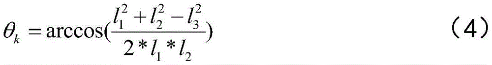
一种实现方式中,取R=6371.004km。In one implementation, R=6371.004 km.
在一个实施例中,步骤S104可以包括以下步骤:In one embodiment, step S104 may include the following steps:
步骤一,针对所述缓存行驶轨迹中的每一轨迹点,计算偏转角度值与平角的差值:Step 1: For each track point in the cached driving track, calculate the difference between the deflection angle value and the straight angle:

其中,
步骤二,将连续的N个轨迹点的角度差值进行计算并累加:Step 2: Calculate and accumulate the angle differences of N consecutive trajectory points:

步骤三,根据N值确定角度累积阈值


一种实现方式中,根据N值可以选取角度累积阈值


一种实现方式中,


本发明的效果可通过下面仿真实验进一步说明。The effect of the present invention can be further illustrated by the following simulation experiment.
仿真实验条件:本发明的仿真实验平台为:处理器为Intel i7-9750 CPU,主频为2.6GHz,内存16GB。Simulation experiment conditions: The simulation experiment platform of the present invention is: the processor is Intel i7-9750 CPU, the main frequency is 2.6GHz, and the memory is 16GB.
本发明的仿真实验的软件平台为:Windows 10系统,IntelliJ IDEA 2020.1.1和ArcMap 10.6。The software platforms for the simulation experiment of the present invention are: Windows 10 system, IntelliJ IDEA 2020.1.1 and ArcMap 10.6.
仿真所用的对比方法是Liu J,Li H,Yang Z在其发表的论文“Adaptive Douglas-Peucker Algorithm With Automatic Thresholding for AIS-Based Vessel TrajectoryCompression”(IEEE Access,2019,7:150677-150692.)中提出的一种改进的DP算法。The comparison method used in the simulation is an improved DP algorithm proposed by Liu J, Li H, and Yang Z in their paper “Adaptive Douglas-Peucker Algorithm With Automatic Thresholding for AIS-Based Vessel Trajectory Compression” (IEEE Access, 2019, 7: 150677-150692.).
仿真实验的轨迹数据来自GeoLife GPS Trajectories的Geolife项目生产的182位用户于2007年04月至2012年08月期间的轨迹数据,记录了用户多种户外活动过程中所发生的移动信息,使用WGS 84坐标系。地图数据来自OSM地图提供的北京矢量地图数据,仿真过程中使用了轨迹数据集中编号030用户在2009年2月10日的轨迹数据,对行驶范围进行了500m×500m的网格划分,累积角度阈值设置为
仿真内容及其结果分析:Simulation content and result analysis:
仿真1,在上述仿真条件下,利用本发明和改进的DP算法分别对030号用户在2009年2月10日的轨迹数据进行轨迹压缩,结果如图3所示,其中:Simulation 1: Under the above simulation conditions, the trajectory data of user No. 030 on February 10, 2009 are compressed using the present invention and the improved DP algorithm. The results are shown in FIG3 , where:
图3(a)表示改进的DP算法对轨迹数据压缩的结果;Figure 3(a) shows the result of trajectory data compression by the improved DP algorithm;
图3(b)表示本发明基于角度阈值自适应的轨迹压缩方法对轨迹数据压缩的结果。FIG3( b ) shows the result of trajectory data compression based on the angle threshold adaptive trajectory compression method of the present invention.
由图3可见,改进的DP算法基于全部的轨迹数据进行压缩,所获得的数据结果分布均匀,本发明的压缩结果则在压缩结果保持均匀的同时有着更高的压缩效率,此外本发明在对数据压缩过程中,一次仅需要N个轨迹点数据即可运行,可以满足实时采集并压缩的需求,实现对轨迹的在线压缩,但改进的DP算法则需要一次获取完整轨迹,现有技术并不能满足在线压缩的需求因而会产生更多的传输和存储压力。As can be seen from FIG3 , the improved DP algorithm performs compression based on all trajectory data, and the obtained data results are evenly distributed. The compression results of the present invention have higher compression efficiency while maintaining uniform compression results. In addition, during the data compression process, the present invention only requires N trajectory point data at a time to run, which can meet the needs of real-time acquisition and compression and realize online compression of the trajectory. However, the improved DP algorithm needs to obtain the complete trajectory at one time. The existing technology cannot meet the needs of online compression and thus will generate more transmission and storage pressure.
仿真2,在上述仿真条件下,对本发明提出的缓存队列的作用进行了验证,结果如图4所示,其中:Simulation 2: Under the above simulation conditions, the effect of the cache queue proposed by the present invention is verified, and the result is shown in FIG4 , where:
图4(a)表示不引入缓存队列的角度阈值自适应的轨迹压缩方法对轨迹数据的压缩结果;FIG4( a ) shows the compression result of trajectory data by the trajectory compression method with angle threshold adaptiveness without introducing a cache queue;
图4(b)表示本发明中引入缓存队列的角度阈值自适应的轨迹压缩方法对轨迹数据的压缩结果。FIG. 4( b ) shows the compression result of trajectory data by the trajectory compression method with adaptive angle threshold of the buffer queue introduced in the present invention.
由图4可见,在不引入缓存队列的方法对车辆轨迹在直行情况下的压缩结果表现较差,出现了连续且密集的近似直线的轨迹段,而本发明通过引入缓存队列,在保持算法复杂度不变的情况下提高了对直行路段处车辆轨迹的压缩效率。As can be seen from Figure 4, the method without introducing the cache queue performs poorly in compressing the vehicle trajectory in the straight-ahead situation, and continuous and dense trajectory segments that are approximately straight lines appear. The present invention, by introducing the cache queue, improves the compression efficiency of the vehicle trajectory in the straight-ahead section while keeping the algorithm complexity unchanged.
以上对本发明的一个实施例进行了详细说明,但所述内容仅为本发明的较佳实施例,不能被认为用于限定本发明的实施范围。凡依本发明申请范围所作的均等变化与改进等,均应仍归属于本发明的专利涵盖范围之内。The above is a detailed description of an embodiment of the present invention, but the content is only a preferred embodiment of the present invention and cannot be considered to limit the scope of implementation of the present invention. All equivalent changes and improvements made within the scope of the present invention should still fall within the scope of the patent coverage of the present invention.
Claims (7)


Priority Applications (1)
| Application Number | Priority Date | Filing Date | Title |
|---|---|---|---|
| CN202210771945.8A CN115334167B (en) | 2022-06-30 | 2022-06-30 | An Angle Threshold Adaptive Trajectory Compression Method |
Applications Claiming Priority (1)
| Application Number | Priority Date | Filing Date | Title |
|---|---|---|---|
| CN202210771945.8A CN115334167B (en) | 2022-06-30 | 2022-06-30 | An Angle Threshold Adaptive Trajectory Compression Method |
Publications (2)
| Publication Number | Publication Date |
|---|---|
| CN115334167A CN115334167A (en) | 2022-11-11 |
| CN115334167B true CN115334167B (en) | 2023-06-09 |
Family
ID=83917693
Family Applications (1)
| Application Number | Title | Priority Date | Filing Date |
|---|---|---|---|
| CN202210771945.8A Expired - Fee Related CN115334167B (en) | 2022-06-30 | 2022-06-30 | An Angle Threshold Adaptive Trajectory Compression Method |
Country Status (1)
| Country | Link |
|---|---|
| CN (1) | CN115334167B (en) |
Families Citing this family (2)
| Publication number | Priority date | Publication date | Assignee | Title |
|---|---|---|---|---|
| CN117076593A (en) * | 2023-10-18 | 2023-11-17 | 中微智创(北京)软件技术有限公司 | A multi-level construction and storage method of dynamic target trajectories based on memory database |
| TWI910503B (en) * | 2023-11-30 | 2026-01-01 | 智易科技股份有限公司 | Vehicle trajectory recording system and method for vehicles with a sensor |
Citations (6)
| Publication number | Priority date | Publication date | Assignee | Title |
|---|---|---|---|---|
| CN103312335A (en) * | 2013-05-20 | 2013-09-18 | 四川智行电子科技有限公司 | Space route vector data accumulation offset real-time compression method for mobile GIS (Geographic Information System) technology |
| CN104467866A (en) * | 2014-10-14 | 2015-03-25 | 福建师范大学 | Angle-based track data compression method and device |
| CN105469435A (en) * | 2016-01-20 | 2016-04-06 | 北京格灵深瞳信息技术有限公司 | Track compression method and device |
| CN106877875A (en) * | 2017-01-22 | 2017-06-20 | 齐鲁工业大学 | A Vehicle Trajectory Compression Method Based on Threshold Combined Algorithm |
| CN112163166A (en) * | 2020-10-27 | 2021-01-01 | 腾讯科技(深圳)有限公司 | Method and device for detecting road attribute, computer readable medium and electronic equipment |
| CN112817943A (en) * | 2021-02-26 | 2021-05-18 | 上海海事大学 | Multi-threshold ship track simplification method based on dead reckoning method |
Family Cites Families (1)
| Publication number | Priority date | Publication date | Assignee | Title |
|---|---|---|---|---|
| CN114667437B (en) * | 2019-08-31 | 2025-12-19 | 辉达公司 | Map creation and positioning for autonomous driving applications |
-
2022
- 2022-06-30 CN CN202210771945.8A patent/CN115334167B/en not_active Expired - Fee Related
Patent Citations (6)
| Publication number | Priority date | Publication date | Assignee | Title |
|---|---|---|---|---|
| CN103312335A (en) * | 2013-05-20 | 2013-09-18 | 四川智行电子科技有限公司 | Space route vector data accumulation offset real-time compression method for mobile GIS (Geographic Information System) technology |
| CN104467866A (en) * | 2014-10-14 | 2015-03-25 | 福建师范大学 | Angle-based track data compression method and device |
| CN105469435A (en) * | 2016-01-20 | 2016-04-06 | 北京格灵深瞳信息技术有限公司 | Track compression method and device |
| CN106877875A (en) * | 2017-01-22 | 2017-06-20 | 齐鲁工业大学 | A Vehicle Trajectory Compression Method Based on Threshold Combined Algorithm |
| CN112163166A (en) * | 2020-10-27 | 2021-01-01 | 腾讯科技(深圳)有限公司 | Method and device for detecting road attribute, computer readable medium and electronic equipment |
| CN112817943A (en) * | 2021-02-26 | 2021-05-18 | 上海海事大学 | Multi-threshold ship track simplification method based on dead reckoning method |
Non-Patent Citations (1)
| Title |
|---|
| 基于运动状态改变的在线全球定位系统轨迹数据压缩;刘磊军;房晨;张磊;鲍苏宁;;计算机应用(第01期);全文 * |
Also Published As
| Publication number | Publication date |
|---|---|
| CN115334167A (en) | 2022-11-11 |
Similar Documents
| Publication | Publication Date | Title |
|---|---|---|
| CN111291776B (en) | Waterway Information Extraction Method Based on Crowdsourced Trajectory Data | |
| CN115334167B (en) | An Angle Threshold Adaptive Trajectory Compression Method | |
| CN112015835B (en) | Geohash compressed map matching method | |
| Tang et al. | A network Kernel Density Estimation for linear features in space–time analysis of big trace data | |
| CN109815993B (en) | Regional Feature Extraction, Database Establishment and Intersection Recognition Method Based on GPS Trajectory | |
| Chen et al. | Compression of GPS trajectories | |
| CN111292356A (en) | Method and device for matching motion trajectory and road | |
| CN110288044B (en) | A Trajectory Simplification Method Based on Trajectory Division and Priority Queue | |
| CN108022006B (en) | Data-driven accessibility probability and region generation method | |
| CN110502596A (en) | A Trajectory Online Sliding Window Compression Method Based on Pedestrian Trajectory Features | |
| CN116543310B (en) | Road line extraction method based on Voronoi diagram and kernel density | |
| CN111740981A (en) | Automobile GPS track data compression method | |
| CN117011692B (en) | A method and related device for road recognition | |
| CN110162997A (en) | Anonymous method for secret protection based on interpolation point | |
| CN118035342A (en) | Urban model display method, system and storage medium based on cloud computing | |
| CN115238834B (en) | User group space-time abnormal pattern recognition method based on trajectory data | |
| CN115909545A (en) | Vehicle track data compression method and device based on fuzzy coding | |
| CN116775784B (en) | Spatial data retrieval method, apparatus, equipment, and storage medium based on Siamese network | |
| Mirvahabi et al. | A Flexible Trajectory Compression Algorithm for Multi-Modal Transportation | |
| Liu et al. | A method for online trajectory simplification by enclosed area metric | |
| CN116610646A (en) | Data compression method, device, equipment and computer readable storage medium | |
| CN114460613A (en) | A Compression Method of Vehicle Trajectory | |
| TW201211509A (en) | Navigation devices | |
| CN117313033B (en) | A method for fusing and compressing multi-source trajectory information | |
| CN117202106B (en) | Regional space place attribute labeling method, system and medium based on signaling data |
Legal Events
| Date | Code | Title | Description |
|---|---|---|---|
| PB01 | Publication | ||
| PB01 | Publication | ||
| SE01 | Entry into force of request for substantive examination | ||
| SE01 | Entry into force of request for substantive examination | ||
| GR01 | Patent grant | ||
| GR01 | Patent grant | ||
| CF01 | Termination of patent right due to non-payment of annual fee |
Granted publication date: 20230609 |
|
| CF01 | Termination of patent right due to non-payment of annual fee |