CN113903103B - Partial image generation device, partial image generation method, and storage medium - Google Patents
Partial image generation device, partial image generation method, and storage medium Download PDFInfo
- Publication number
- CN113903103B CN113903103B CN202110658155.4A CN202110658155A CN113903103B CN 113903103 B CN113903103 B CN 113903103B CN 202110658155 A CN202110658155 A CN 202110658155A CN 113903103 B CN113903103 B CN 113903103B
- Authority
- CN
- China
- Prior art keywords
- image
- road
- vehicle
- partial image
- partial
- Prior art date
- Legal status (The legal status is an assumption and is not a legal conclusion. Google has not performed a legal analysis and makes no representation as to the accuracy of the status listed.)
- Active
Links
Images


Classifications
-
- G—PHYSICS
- G07—CHECKING-DEVICES
- G07C—TIME OR ATTENDANCE REGISTERS; REGISTERING OR INDICATING THE WORKING OF MACHINES; GENERATING RANDOM NUMBERS; VOTING OR LOTTERY APPARATUS; ARRANGEMENTS, SYSTEMS OR APPARATUS FOR CHECKING NOT PROVIDED FOR ELSEWHERE
- G07C5/00—Registering or indicating the working of vehicles
- G07C5/08—Registering or indicating performance data other than driving, working, idle, or waiting time, with or without registering driving, working, idle or waiting time
- G07C5/0841—Registering performance data
- G07C5/085—Registering performance data using electronic data carriers
- G07C5/0866—Registering performance data using electronic data carriers the electronic data carrier being a digital video recorder in combination with video camera
-
- B—PERFORMING OPERATIONS; TRANSPORTING
- B60—VEHICLES IN GENERAL
- B60R—VEHICLES, VEHICLE FITTINGS, OR VEHICLE PARTS, NOT OTHERWISE PROVIDED FOR
- B60R11/00—Arrangements for holding or mounting articles, not otherwise provided for
- B60R11/04—Mounting of cameras operative during drive; Arrangement of controls thereof relative to the vehicle
-
- B—PERFORMING OPERATIONS; TRANSPORTING
- B60—VEHICLES IN GENERAL
- B60R—VEHICLES, VEHICLE FITTINGS, OR VEHICLE PARTS, NOT OTHERWISE PROVIDED FOR
- B60R1/00—Optical viewing arrangements; Real-time viewing arrangements for drivers or passengers using optical image capturing systems, e.g. cameras or video systems specially adapted for use in or on vehicles
- B60R1/20—Real-time viewing arrangements for drivers or passengers using optical image capturing systems, e.g. cameras or video systems specially adapted for use in or on vehicles
- B60R1/22—Real-time viewing arrangements for drivers or passengers using optical image capturing systems, e.g. cameras or video systems specially adapted for use in or on vehicles for viewing an area outside the vehicle, e.g. the exterior of the vehicle
- B60R1/28—Real-time viewing arrangements for drivers or passengers using optical image capturing systems, e.g. cameras or video systems specially adapted for use in or on vehicles for viewing an area outside the vehicle, e.g. the exterior of the vehicle with an adjustable field of view
-
- G—PHYSICS
- G06—COMPUTING OR CALCULATING; COUNTING
- G06T—IMAGE DATA PROCESSING OR GENERATION, IN GENERAL
- G06T11/00—Two-dimensional [2D] image generation
- G06T11/60—Creating or editing images; Combining images with text
- G06T11/65—Creating or editing images; Combining images with text on geographic maps
-
- G—PHYSICS
- G06—COMPUTING OR CALCULATING; COUNTING
- G06T—IMAGE DATA PROCESSING OR GENERATION, IN GENERAL
- G06T7/00—Image analysis
- G06T7/70—Determining position or orientation of objects or cameras
- G06T7/73—Determining position or orientation of objects or cameras using feature-based methods
- G06T7/74—Determining position or orientation of objects or cameras using feature-based methods involving reference images or patches
-
- G—PHYSICS
- G07—CHECKING-DEVICES
- G07C—TIME OR ATTENDANCE REGISTERS; REGISTERING OR INDICATING THE WORKING OF MACHINES; GENERATING RANDOM NUMBERS; VOTING OR LOTTERY APPARATUS; ARRANGEMENTS, SYSTEMS OR APPARATUS FOR CHECKING NOT PROVIDED FOR ELSEWHERE
- G07C5/00—Registering or indicating the working of vehicles
- G07C5/008—Registering or indicating the working of vehicles communicating information to a remotely located station
-
- G—PHYSICS
- G07—CHECKING-DEVICES
- G07C—TIME OR ATTENDANCE REGISTERS; REGISTERING OR INDICATING THE WORKING OF MACHINES; GENERATING RANDOM NUMBERS; VOTING OR LOTTERY APPARATUS; ARRANGEMENTS, SYSTEMS OR APPARATUS FOR CHECKING NOT PROVIDED FOR ELSEWHERE
- G07C5/00—Registering or indicating the working of vehicles
- G07C5/08—Registering or indicating performance data other than driving, working, idle, or waiting time, with or without registering driving, working, idle or waiting time
- G07C5/0841—Registering performance data
- G07C5/085—Registering performance data using electronic data carriers
-
- H—ELECTRICITY
- H04—ELECTRIC COMMUNICATION TECHNIQUE
- H04L—TRANSMISSION OF DIGITAL INFORMATION, e.g. TELEGRAPHIC COMMUNICATION
- H04L67/00—Network arrangements or protocols for supporting network services or applications
- H04L67/01—Protocols
- H04L67/06—Protocols specially adapted for file transfer, e.g. file transfer protocol [FTP]
-
- H—ELECTRICITY
- H04—ELECTRIC COMMUNICATION TECHNIQUE
- H04L—TRANSMISSION OF DIGITAL INFORMATION, e.g. TELEGRAPHIC COMMUNICATION
- H04L67/00—Network arrangements or protocols for supporting network services or applications
- H04L67/01—Protocols
- H04L67/12—Protocols specially adapted for proprietary or special-purpose networking environments, e.g. medical networks, sensor networks, networks in vehicles or remote metering networks
-
- H—ELECTRICITY
- H04—ELECTRIC COMMUNICATION TECHNIQUE
- H04N—PICTORIAL COMMUNICATION, e.g. TELEVISION
- H04N5/00—Details of television systems
- H04N5/222—Studio circuitry; Studio devices; Studio equipment
- H04N5/262—Studio circuits, e.g. for mixing, switching-over, change of character of image, other special effects ; Cameras specially adapted for the electronic generation of special effects
- H04N5/265—Mixing
-
- B—PERFORMING OPERATIONS; TRANSPORTING
- B60—VEHICLES IN GENERAL
- B60R—VEHICLES, VEHICLE FITTINGS, OR VEHICLE PARTS, NOT OTHERWISE PROVIDED FOR
- B60R2300/00—Details of viewing arrangements using cameras and displays, specially adapted for use in a vehicle
- B60R2300/20—Details of viewing arrangements using cameras and displays, specially adapted for use in a vehicle characterised by the type of display used
- B60R2300/205—Details of viewing arrangements using cameras and displays, specially adapted for use in a vehicle characterised by the type of display used using a head-up display
-
- B—PERFORMING OPERATIONS; TRANSPORTING
- B60—VEHICLES IN GENERAL
- B60R—VEHICLES, VEHICLE FITTINGS, OR VEHICLE PARTS, NOT OTHERWISE PROVIDED FOR
- B60R2300/00—Details of viewing arrangements using cameras and displays, specially adapted for use in a vehicle
- B60R2300/30—Details of viewing arrangements using cameras and displays, specially adapted for use in a vehicle characterised by the type of image processing
- B60R2300/302—Details of viewing arrangements using cameras and displays, specially adapted for use in a vehicle characterised by the type of image processing combining image information with GPS information or vehicle data, e.g. vehicle speed, gyro, steering angle data
-
- B—PERFORMING OPERATIONS; TRANSPORTING
- B60—VEHICLES IN GENERAL
- B60R—VEHICLES, VEHICLE FITTINGS, OR VEHICLE PARTS, NOT OTHERWISE PROVIDED FOR
- B60R2300/00—Details of viewing arrangements using cameras and displays, specially adapted for use in a vehicle
- B60R2300/30—Details of viewing arrangements using cameras and displays, specially adapted for use in a vehicle characterised by the type of image processing
- B60R2300/306—Details of viewing arrangements using cameras and displays, specially adapted for use in a vehicle characterised by the type of image processing using a re-scaling of images
-
- G—PHYSICS
- G06—COMPUTING OR CALCULATING; COUNTING
- G06T—IMAGE DATA PROCESSING OR GENERATION, IN GENERAL
- G06T2207/00—Indexing scheme for image analysis or image enhancement
- G06T2207/30—Subject of image; Context of image processing
- G06T2207/30248—Vehicle exterior or interior
- G06T2207/30252—Vehicle exterior; Vicinity of vehicle
-
- G—PHYSICS
- G08—SIGNALLING
- G08G—TRAFFIC CONTROL SYSTEMS
- G08G1/00—Traffic control systems for road vehicles
- G08G1/09—Arrangements for giving variable traffic instructions
- G08G1/0962—Arrangements for giving variable traffic instructions having an indicator mounted inside the vehicle, e.g. giving voice messages
- G08G1/0968—Systems involving transmission of navigation instructions to the vehicle
- G08G1/096855—Systems involving transmission of navigation instructions to the vehicle where the output is provided in a suitable form to the driver
-
- G—PHYSICS
- G08—SIGNALLING
- G08G—TRAFFIC CONTROL SYSTEMS
- G08G1/00—Traffic control systems for road vehicles
- G08G1/09—Arrangements for giving variable traffic instructions
- G08G1/0962—Arrangements for giving variable traffic instructions having an indicator mounted inside the vehicle, e.g. giving voice messages
- G08G1/0968—Systems involving transmission of navigation instructions to the vehicle
- G08G1/0969—Systems involving transmission of navigation instructions to the vehicle having a display in the form of a map
-
- H—ELECTRICITY
- H04—ELECTRIC COMMUNICATION TECHNIQUE
- H04N—PICTORIAL COMMUNICATION, e.g. TELEVISION
- H04N23/00—Cameras or camera modules comprising electronic image sensors; Control thereof
- H04N23/60—Control of cameras or camera modules
- H04N23/69—Control of means for changing angle of the field of view, e.g. optical zoom objectives or electronic zooming
-
- H—ELECTRICITY
- H04—ELECTRIC COMMUNICATION TECHNIQUE
- H04N—PICTORIAL COMMUNICATION, e.g. TELEVISION
- H04N23/00—Cameras or camera modules comprising electronic image sensors; Control thereof
- H04N23/80—Camera processing pipelines; Components thereof
Landscapes
- Engineering & Computer Science (AREA)
- General Physics & Mathematics (AREA)
- Physics & Mathematics (AREA)
- Multimedia (AREA)
- Theoretical Computer Science (AREA)
- Signal Processing (AREA)
- Mechanical Engineering (AREA)
- Computer Networks & Wireless Communication (AREA)
- Computer Vision & Pattern Recognition (AREA)
- Health & Medical Sciences (AREA)
- Computing Systems (AREA)
- General Health & Medical Sciences (AREA)
- Medical Informatics (AREA)
- Image Processing (AREA)
- Image Analysis (AREA)
- Navigation (AREA)
- Traffic Control Systems (AREA)
Abstract
Description
技术领域technical field
本发明涉及局部图像生成装置以及存储局部图像生成用计算机程序的存储介质。The present invention relates to a partial image generation device and a storage medium storing a computer program for partial image generation.
背景技术Background technique
需要在车辆的自动驾驶系统为对车辆进行自动控制而参照的高精度的道路的地图上准确地呈现与道路有关的信息。期望在地图上尽量多地登记出车辆能够行驶的道路以及道路周边的道路特征物。It is necessary to accurately present road-related information on a high-precision road map that an automatic driving system of a vehicle refers to for automatic control of the vehicle. It is desirable to register as many roads on which vehicles can drive and road features around the roads as possible on the map.
另外,车道划分线、标识或者构造物等道路特征物有时被变更或者位置发生移动。因而,对地图而言,优选这些道路特征物的信息始终处于新的状态。In addition, road features such as lane dividing lines, signs, or structures may be changed or moved. Therefore, for the map, it is preferable that the information of these road features is always in a new state.
因而,提出了服务器从多个车辆适当地收集与道路有关的信息,并进行向地图的登记以及地图的更新。例如,车辆利用设置于车辆的摄像机对车辆的前方依次进行拍摄,关于拍摄到的图像分别截取被推测为呈现有道路的区域的局部图像,并发送到服务器。服务器生成接收到的多个局部图像各自的俯视图像,将多个俯视图像接在一起而生成呈现有道路的图像(例如,参照专利文献1)。服务器根据该图像检测道路特征物,将新的道路特征物与道路关联起来登记到地图上。另外,服务器根据该图像,关于发生变更的道路特征物进行地图的更新。Therefore, it has been proposed that a server appropriately collects road-related information from a plurality of vehicles, and performs registration and update of the map. For example, the vehicle sequentially captures images in front of the vehicle with a camera installed in the vehicle, and cuts out partial images of areas estimated to have roads from the captured images, and sends them to the server. The server generates respective bird's-eye images of the plurality of partial images received, and generates an image representing a road by concatenating the plurality of bird's-eye images (for example, refer to Patent Document 1). The server detects road features based on the image, and associates new road features with roads and registers them on the map. In addition, the server updates the map with respect to the changed road feature based on the image.
现有技术文献prior art literature
专利文献patent documents
专利文献1:日本特开2015-204017号公报Patent Document 1: Japanese Patent Laid-Open No. 2015-204017
发明内容Contents of the invention
关于由车辆的摄像机拍摄到的图像,针对每种车辆,摄像机的安装位置以及光轴等有时不同。因此,针对每个局部图像,有时从车辆接收到的局部图像所呈现的道路的位置不同。因此,在服务器使用从多个车辆接收到的多个局部图像来生成道路的俯视图像的情况下,有时难以将多个俯视图像接在一起而生成呈现出道路的图像。Regarding images captured by a camera of a vehicle, the installation position of the camera, the optical axis, and the like may differ for each vehicle. Therefore, the position of the road represented by the partial image received from the vehicle may differ for each partial image. Therefore, when the server generates a bird's-eye view image of a road using a plurality of partial images received from a plurality of vehicles, it may be difficult to generate an image representing the road by joining the plurality of bird-view images.
因而,本发明的目的在于提供一种局部图像生成装置,该局部图像生成装置将多个局部图像分别变换为俯视图像,生成易于进行将这些多个俯视图像接在一起而生成呈现出道路的图像的处理的局部图像。Therefore, an object of the present invention is to provide a partial image generating device that converts a plurality of partial images into bird's-eye images and generates an image representing a road by easily joining the plurality of bird's-eye images. The processed partial image.
根据一个实施方式,提供一种局部图像生成装置。该局部图像生成装置的特征在于,具有:局部图像生成部,从使用设置于车辆的摄像部对车辆的周围的环境进行拍摄而得到的图像生成局部图像;以及判定部,判定图像所呈现的道路是否为直线,在判定为图像所呈现的道路为直线的情况下,局部图像生成部截取根据道路的消失点而被推测为呈现有道路的图像内的第1区域而生成为局部图像,在判定为图像所呈现的道路不为直线的情况下,截取根据车辆的种类决定的图像内的第2区域而生成为局部图像。According to one embodiment, a partial image generation device is provided. This partial image generation device is characterized by comprising: a partial image generation unit for generating a partial image from an image obtained by capturing an environment around the vehicle by an imaging unit provided in the vehicle; and a determination unit for determining a road represented by the image. Whether it is a straight line, if it is determined that the road represented by the image is a straight line, the partial image generation unit intercepts the first region in the image that is estimated to represent the road based on the vanishing point of the road and generates it as a partial image. When the road represented by the image is not a straight line, a second region within the image determined according to the type of the vehicle is cut out to generate a partial image.
在该局部图像生成装置中,优选第2区域中的车辆的宽度方向的尺寸比第1区域中的车辆的宽度方向的尺寸大。In this partial image generating device, it is preferable that the size of the vehicle in the width direction in the second area is larger than the size of the vehicle in the width direction in the first area.
另外,在该局部图像生成装置中,优选具有存储地图信息的存储部,判定部根据拍摄图像时的车辆的位置和存储于存储部的地图信息,判定图像所呈现的道路是否为直线。In addition, the partial image generation device preferably has a storage unit storing map information, and the determination unit determines whether the road represented by the image is a straight line based on the position of the vehicle when the image is captured and the map information stored in the storage unit.
另外,在该局部图像生成装置中,优选判定部根据图像所呈现的道路的形状判定图像所呈现的道路是否为直线。In addition, in the partial image generation device, it is preferable that the determination unit determines whether the road represented by the image is a straight line based on the shape of the road represented by the image.
另外,在该局部图像生成装置中,优选还具有第1校正部,在判定为图像所呈现的道路不为直线的情况下,该第1校正部判定图像所呈现的道路是右转弯的道路还是左转弯的道路,并根据判定结果校正图像内的第2区域的位置。In addition, the partial image generation device preferably further includes a first correcting unit for determining whether the road represented by the image is a right-turning road or a straight line when it is determined that the road represented by the image is not a straight line. On a road that turns left, the position of the second area in the image is corrected based on the judgment result.
另外,在该局部图像生成装置中,优选还具有第2校正部,该第2校正部当判定为在拍摄图像时车辆在路面的起伏大的道路上行驶的情况下,使第1区域或者第2区域的车辆的高度方向的尺寸比未判定为车辆在路面的起伏大的道路上行驶的情况扩大。In addition, the partial image generating device preferably further includes a second correcting unit that, when it is determined that the vehicle is traveling on a road with large road surface undulations when the image is captured, sets the first area or the second correcting unit to The dimension in the height direction of the vehicle in the 2 area is larger than when it is not determined that the vehicle is traveling on a road with a large undulation of the road surface.
另外,在该局部图像生成装置中,优选第2校正部根据车辆的俯仰角的变化判定车辆是否在路面的起伏大的道路上行驶。In addition, in the partial image generation device, it is preferable that the second correction unit determines whether or not the vehicle is traveling on a road with large undulations of the road surface based on a change in the pitch angle of the vehicle.
另外,在该局部图像生成装置中,优选还具有第3校正部,该第3校正部根据拍摄图像时的车辆的车辆速度来变更第1区域或者第2区域的尺寸。In addition, the partial image generation device preferably further includes a third correction unit that changes the size of the first region or the second region according to the vehicle speed of the vehicle when the image is captured.
另外,在该局部图像生成装置中,优选在车辆的车辆速度为高速的情况下,第3校正部使第1区域或者第2区域的尺寸比车辆的车辆速度为低速时扩大。In addition, in the partial image generation device, preferably, when the vehicle speed is high, the third correction unit increases the size of the first region or the second region compared to when the vehicle speed is low.
另外,根据其它实施方式,提供一种非临时性存储介质,存储计算机能够读取的局部图像生成用计算机程序。该局部图像生成用计算机程序使处理器执行:从使用设置于车辆的摄像部对车辆的周围的环境进行拍摄而得到的图像生成局部图像,并判定图像所呈现的道路是否为直线。该局部图像生成用计算机程序使处理器执行:在判定为图像所呈现的道路为直线的情况下,截取根据道路的消失点而被推测为呈现有道路的图像内的第1区域,生成为局部图像,在被判定为图像所呈现的道路不为直线的情况下,截取基于车辆的种类决定的图像内的第2区域,生成为局部图像。In addition, according to another embodiment, there is provided a non-transitory storage medium storing a computer-readable computer program for generating a partial image. The computer program for generating a partial image causes the processor to generate a partial image from an image obtained by capturing an environment around the vehicle using an imaging unit provided in the vehicle, and determine whether a road represented by the image is a straight line. The computer program for generating the partial image causes the processor to execute: when it is determined that the road represented by the image is a straight line, intercept the first region in the image that is estimated to represent the road based on the vanishing point of the road, and generate a partial image. In the image, when it is determined that the road represented by the image is not a straight line, a second region within the image determined based on the type of the vehicle is cut out to generate a partial image.
另外,根据又一其它实施方式,提供一种局部图像生成方法,由局部图像生成装置执行,该局部图像生成装置从使用设置于车辆的摄像部对车辆的周围的环境进行拍摄而得到的图像生成局部图像,并判定图像所呈现的道路是否为直线。在局部图像生成方法中,局部图像生成装置在判定为图像所呈现的道路为直线的情况下,截取根据道路的消失点而推测为呈现有道路的图像内的第1区域,生成为局部图像,在判定为图像所呈现的道路不为直线的情况下,截取根据车辆的种类决定的图像内的第2区域,生成为局部图像。In addition, according to yet another embodiment, there is provided a partial image generation method executed by a partial image generation device that generates a partial image from an image obtained by capturing an environment around the vehicle using an imaging unit provided in the vehicle. Partial image, and determine whether the road presented by the image is a straight line. In the partial image generating method, when the partial image generating device determines that the road represented by the image is a straight line, it intercepts a first region in the image estimated to represent the road based on the vanishing point of the road, and generates the partial image, When it is determined that the road represented by the image is not a straight line, a second region within the image determined according to the type of the vehicle is cut out to generate a partial image.
本发明的局部图像生成装置起到如下效果:将多个局部图像分别变换为俯视图像,能够生成易于进行将这些多个俯视图像接在一起而生成呈现出道路的图像的处理的局部图像。The partial image generation device of the present invention has the effect of converting a plurality of partial images into bird's-eye images and generating a partial image that is easy to process by joining the plurality of bird's-eye images to generate an image representing a road.
附图说明Description of drawings
图1是说明局部图像生成装置的动作的概要的图。FIG. 1 is a diagram illustrating an outline of the operation of the partial image generation device.
图2是安装局部图像生成装置的车辆的概略结构图。FIG. 2 is a schematic configuration diagram of a vehicle equipped with a partial image generation device.
图3是说明示出抬头显示器的型号与截取区域之间的关系的表的图。FIG. 3 is a diagram illustrating a table showing a relationship between a model number of a head-up display and a clipping area.
图4是局部图像生成装置的动作流程图。Fig. 4 is an operation flowchart of the partial image generation device.
图5是说明局部图像生成部的处理的图(其一)。FIG. 5 is a diagram (Part 1) illustrating processing of a partial image generation unit.
图6是说明局部图像生成部的处理的图(其二)。Fig. 6 is a diagram (Part 2) illustrating processing of a partial image generation unit.
图7是消失点检测部的动作流程图。FIG. 7 is an operation flowchart of a vanishing point detection unit.
图8是说明消失点检测部的处理的图。FIG. 8 is a diagram illustrating processing of a vanishing point detection unit.
图9是说明校正部的处理的图(其一)。Fig. 9 is a diagram (Part 1) for explaining the processing of the correction unit.
图10是说明校正部的处理的图(其二)。Fig. 10 is a diagram (Part 2) explaining the processing of the correction unit.
图11是说明校正部的处理的图(其三)。Fig. 11 is a diagram (Part 3) for explaining the processing of the correction unit.
符号说明Symbol Description
10:车辆;101:前车窗;11:摄像机;12:无线通信终端;13:车速传感器;14:俯仰角传感器;15:抬头显示器;16:定位信息接收机;17:地图信息存储装置;18:局部图像生成装置;19:车内网络;21:通信接口;22:存储器;23:处理器;24:信号线;31:局部图像生成部;32:判定部;33:消失点检测部;34:校正部;40:摄像机图像;41~49:区域。10: Vehicle; 101: Front window; 11: Camera; 12: Wireless communication terminal; 13: Vehicle speed sensor; 14: Pitch angle sensor; 15: Head-up display; 16: Positioning information receiver; 17: Map information storage device; 18: Local image generation device; 19: In-vehicle network; 21: Communication interface; 22: Memory; 23: Processor; 24: Signal line; 31: Partial image generation unit; 32: Judgment unit; 33: Vanishing point detection unit ; 34: correction unit; 40: camera image; 41-49: areas.
具体实施方式Detailed ways
图1是说明局部图像生成装置的动作的概要的图。以下,参照图1,说明本说明书所公开的局部图像生成装置的动作的概要。FIG. 1 is a diagram illustrating an outline of the operation of the partial image generation device. Hereinafter, an outline of the operation of the partial image generation device disclosed in this specification will be described with reference to FIG. 1 .
在本实施方式中,在车辆10在道路R上行驶的过程中,搭载于车辆10的局部图像生成装置18的局部图像生成部31使用作为设置于车辆10的摄像部的一个例子的摄像机11,拍摄呈现有车辆10周边的环境的摄像机图像40。In the present embodiment, while the
局部图像生成装置18的判定部32根据地图信息或者摄像机图像40判定摄像机图像40所呈现的道路是否为直线(笔直)。The
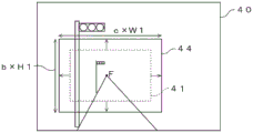
在判定为摄像机图像40所呈现的道路为直线的情况下,如图1的(A)所示,局部图像生成部31从摄像机图像40截取出截取区域41而生成为局部图像,该截取区域41是基于道路的消失点F而决定的、被推测为呈现有道路的区域。When it is determined that the road represented by the
另一方面,在判定为摄像机图像40所呈现的道路不为直线的情况下,一般难以推测道路的消失点F。因而,如图1的(B)所示,局部图像生成部31从摄像机图像40截取基于车辆10的种类决定的摄像机图像40内的截取区域42,生成为局部图像。另外,作为车辆的种类,例如可举出轿车、两厢车、运动型多用途车(SUV)等。摄像机在车辆安装的高度以及引擎盖的长度等根据车辆的种类而不同,所以摄像机的光轴的朝向也不同。因此,根据车辆的种类,在摄像机图像40内被推测为呈现有道路的区域也不同。因而,局部图像生成部31根据车辆的种类决定摄像机图像40内的截取区域42。On the other hand, when it is determined that the road represented by the
局部图像生成部31将局部图像连同拍摄到局部图像的车辆10的位置一起发送到服务器(未图示)。在图1的(C)所示的例子中,服务器从车辆10接收呈现有道路R的两个局部图像C1、C2。另外,服务器从其它车辆(未图示)接收呈现有相同的道路R的局部图像C3。局部图像C1、C2和局部图像C3是从不同的车辆接收到的图像,但在3个局部图像C1、C2、C3各自中道路R呈现于相同的位置。The partial
如图1的(D)所示,服务器生成呈现有相同的道路R的3个局部图像C1、C2、C3各自的俯视图像D1、D2、D3。然后,如图1的(E)所示,服务器将3个俯视图像D1、D2、D3接在一起,生成呈现有道路R的一个道路图像。由于在局部图像C1、C2、C3各自中,在相同的位置处呈现出道路,所以服务器能够容易地将从拍摄相同的道路R得到的3个局部图像生成的3个俯视图像D1、D2、D3接在一起,生成呈现有道路R的道路图像。As shown in (D) of FIG. 1 , the server generates bird's-eye images D1 , D2 , and D3 , respectively, of the three partial images C1 , C2 , and C3 representing the same road R. Then, as shown in (E) of FIG. 1 , the server concatenates the three bird's-eye images D1 , D2 , and D3 to generate one road image showing the road R. In each of the partial images C1, C2, and C3, roads are shown at the same positions, so the server can easily display the three bird's-eye images D1, D2, and D3 generated from the three partial images obtained by photographing the same road R. Together, a road image representing the road R is generated.
另一方面,关于由车辆的摄像机拍摄到的图像,当摄像机的安装位置以及光轴等按照车辆而不同时,关于相同的道路,从多个车辆接收到的局部图像所呈现的道路的位置将按照图像而不同。因此,在从多个局部图像分别生成的俯视图像中,道路的位置也按照俯视图像而不同。因此,在现有技术中,服务器将多个俯视图像接在一起而生成呈现有道路的图像的处理的负荷有时增大。On the other hand, with regard to the images captured by the cameras of the vehicles, when the installation positions of the cameras and the optical axis etc. are different for each vehicle, the positions of the roads represented by the partial images received from a plurality of vehicles will be different for the same road. It varies according to the image. Therefore, in bird's-eye images generated from a plurality of partial images, the position of the road also differs for each bird's-eye image. Therefore, in the prior art, the processing load on the server to concatenate a plurality of bird's-eye images to generate an image showing a road may increase.
图2是安装局部图像生成装置18的车辆10的概略结构图。车辆10具有摄像机11、无线通信终端12、车速传感器13、俯仰角传感器14、抬头显示器15、定位信息接收机16、地图信息存储装置17、局部图像生成装置18、前车窗101等。FIG. 2 is a schematic configuration diagram of a
摄像机11、无线通信终端12、车速传感器13、俯仰角传感器14、抬头显示器15、定位信息接收机16、地图信息存储装置17以及局部图像生成装置18经由诸如遵循控制器局域网络的标准的车内网络19连接为能够通信。The
摄像机11是设置于车辆10的摄像部的一个例子。摄像机11以朝着车辆10的前方的方式例如安装于车辆10的车室内。摄像机11由局部图像生成装置18控制,例如以预定的周期拍摄呈现有车辆10前方的预定区域的环境的摄像机图像40。在摄像机图像40中,能够呈现出车辆10前方的预定区域内所包含的道路及其路面上的车道划分线等道路特征物。摄像机11例如以使其光轴与车辆10前方的地面交叉的位置与车辆10的距离为8.5m~16.5m的方式安装于车辆10。由摄像机11生成的图像既可以是彩色图像,或者也可以是灰度图像。摄像机11具有由CCD或者C-MOS等对于可见光具有灵敏度的光电变换元件的阵列构成的二维检测器和在该二维检测器上成像作为拍摄对象的区域的像的摄像光学系统。The
无线通信终端12是通信部的一个例子,是执行遵循预定的无线通信标准的无线通信处理的设备,例如,经由未图示的基站以及通信网络而与服务器(未图示)连接。The
车速传感器13检测车辆10的车辆速度。车速传感器13例如具有测量车辆10的轮胎的转速的测量部,根据轮胎的转速和轮胎的外周长来检测车辆速度。车速传感器13经由车内网络19将车辆速度输出到局部图像生成装置18。此外,车速传感器13也可以将轮胎的转速输出到局部图像生成装置18,并在局部图像生成装置18中根据轮胎的转速和轮胎的外周长求出车辆速度。The
俯仰角传感器14检测车辆10的俯仰角。俯仰角传感器14例如使用加速度传感器形成。俯仰角传感器14检测绕车辆坐标系的xv轴的俯仰角,该车辆坐标系以车辆10的左右后轮之间的中点且地面上的点为原点,以车辆10的行进方向为zv轴,以与zv轴正交且与地面平行的方向为xv轴,以铅垂方向为yv轴。当车辆10在路面的起伏大的道路或者倾斜的道路上行驶时,车辆10以绕xv轴旋转的方式运动,所以俯仰角发生变化。
抬头显示器15由未图示的车辆控制装置等控制,将与车辆10的行驶相伴的各种信息投影到前车窗101。抬头显示器15根据所搭载的车辆的种类不同而投影角度以及安装构造等不同,所以针对车辆的每个种类而具有不同的型号。例如,抬头显示器15将由未图示的导航装置生成的车辆10的当前地点至目的地的行驶路线投影到前车窗101。The head-up
定位信息接收机16输出表示车辆10的当前地点的定位信息。例如,定位信息接收机16能够采用GNSS接收机。定位信息接收机16每当以预定的接收周期获取到定位信息时,将定位信息以及获取到定位信息的定位信息获取时刻输出到摄像机11以及局部图像生成装置18。The
地图信息存储装置17存储包括道路的地图。在地图中,一条道路被分割为多个道路区间而登记。在地图中,各道路区间的曲率半径与道路区间关联起来登记。The map information storage means 17 stores maps including roads. In the map, one road is divided into a plurality of road sections and registered. In the map, the radius of curvature of each road section is registered in association with the road section.
局部图像生成装置18执行从摄像机图像40生成局部图像的局部图像生成处理。另外,局部图像生成装置18执行判定摄像机图像40所呈现的道路是否为直线的判定处理。另外,局部图像生成装置18执行检测摄像机图像40内的道路的消失点F的消失点检测处理。进而,局部图像生成装置18执行校正摄像机图像40内的截取区域的位置或者尺寸的校正处理。因此,局部图像生成装置18具有通信接口21、存储器22以及处理器23。通信接口21、存储器22以及处理器23经由信号线24连接。The partial
通信接口(IF)21是车内通信部的一个例子,具有用于将局部图像生成装置18与车内网络19连接的接口电路。即,通信IF21经由车内网络19而与摄像机11、无线通信终端12、车速传感器13、俯仰角传感器14、抬头显示器15、定位信息接收机16以及地图信息存储装置17等连接。例如,通信接口21当从处理器23输入局部图像以及拍摄局部图像时的车辆10的位置时,将所输入的局部图像以及拍摄局部图像时的车辆10的位置输出到无线通信终端12。The communication interface (IF) 21 is an example of an in-vehicle communication unit, and has an interface circuit for connecting the partial
存储器22是存储部的一个例子,例如具有易失性的半导体存储器以及非易失性的半导体存储器。而且,存储器22存储在由局部图像生成装置18的处理器23执行的信息处理中使用的应用的计算机程序以及各种数据。另外,存储器22存储诸如摄像机11的光轴方向以及安装位置等设置位置信息、成像光学系统的焦点距离以及视场角的内部参数等。另外,存储器22存储抬头显示器15的型号和表示该型号与从摄像机图像40内截取局部图像的截取区域的关系的表60。The
图3是说明示出抬头显示器的型号与截取区域的关系的表60的图。表60具有表示抬头显示器的型号的型号栏601、表示摄像机图像40内的截取区域的基准位置的基准位置栏602、表示截取区域的横向尺寸的横向长度栏603以及表示截取区域的纵向尺寸的纵向长度栏604。在型号栏601中,登记表示搭载于轿车的抬头显示器的型号的T1、表示搭载于两厢车的抬头显示器的型号的T2以及表示搭载于运动型多用途车的抬头显示器的型号的T3。基准位置能够利用图像坐标系表示,该图像坐标系以摄像机图像40的左上角的位置为原点,具有向右方延伸的xi轴和向下方延伸的yi轴。与登记于表60的截取区域有关的信息能够根据车辆的每个种类的摄像机的安装位置以及光轴、引擎盖的高度等来决定。FIG. 3 is a diagram illustrating a table 60 showing the relationship between the model number of the head-up display and the clipping area. The table 60 has a
处理器23具有一个或者多个CPU(Central Processing Unit,中央处理单元)及其周边电路。处理器23也可以还具有诸如逻辑运算单元、数值运算单元或者图形处理单元的其它运算电路。在处理器23具有多个CPU的情况下,也可以针对每个CPU而具有存储器。处理器23执行局部图像生成处理、判定处理、消失点检测处理以及校正处理。The
处理器23具有执行局部图像生成处理的局部图像生成部31、执行判定处理的判定部32、执行消失点检测处理的消失点检测部33以及执行校正处理的校正部34。处理器23所具有的这些各部分例如是通过在处理器23上动作的计算机程序实现的功能模块。或者,处理器23所具有的这些各部分也可以是设置于处理器23的专用的运算电路。The
图4是局部图像生成装置18的动作流程图。在车辆10的行驶过程中,局部图像生成装置18依照图4所示的动作流程图重复执行局部图像生成处理。FIG. 4 is an operation flowchart of the partial
设置于车辆10的摄像机11由局部图像生成装置18的处理器23的局部图像生成部31控制,拍摄呈现有车辆10前方的环境的摄像机图像40进行(步骤S101)。摄像机11经由车内网络19将摄像机图像40和拍摄到摄像机图像40时的摄像机图像拍摄时刻输出到局部图像生成装置18。另外,摄像机11经由车内网络19将摄像机图像拍摄时刻输出到地图信息存储装置17。地图信息存储装置17每当从摄像机11接收到摄像机图像拍摄时刻时,推测由摄像机图像拍摄时刻的定位信息表示的车辆10的位置(摄像机图像拍摄时刻的车辆10的位置),该摄像机图像拍摄时刻的定位信息是根据与摄像机图像拍摄时刻一致或者摄像机图像拍摄时刻前后的时刻的定位信息而推测出的。地图信息存储装置17将摄像机图像拍摄时刻、摄像机图像拍摄时刻的车辆10的位置以及包括摄像机图像拍摄时刻的车辆10的位置的预定的区域(例如,200m见方)的地图输出到局部图像生成装置18。局部图像生成装置18的处理器23的判定部32将摄像机图像拍摄时刻、摄像机图像拍摄时刻的车辆10的位置以及地图关联起来存储于存储器22。The
接下来,局部图像生成装置18的处理器23的判定部32利用从地图信息存储装置17输出的地图,判定摄像机图像40所呈现的道路是否为直线(笔直)(步骤S102)。关于步骤S102中的判定处理的详细内容将在后面叙述。Next, the judging
接下来,在被判定为摄像机图像40所呈现的道路为直线的情况下(步骤S102-“是”),局部图像生成装置18的处理器23的消失点检测部33求出摄像机图像40内的道路的消失点F(步骤S103)。关于步骤S103中的求出消失点F的处理的详细内容将在后面叙述。Next, when it is determined that the road represented by the
接下来,局部图像生成部31根据道路的消失点F决定摄像机图像40内的截取区域41(步骤S104)。例如,局部图像生成部31以使道路的消失点F作为预先决定的横向长度W1以及纵向长度H1的矩形形状的中心的方式决定截取区域41。图5示出根据消失点F而从摄像机图像40内决定的截取区域41的一个例子。此外,也可以采用根据消失点F与预先决定的基准位置的位置关系等来决定截取区域41等的其它方法。Next, the partial
另一方面,在判定为摄像机图像40所呈现的道路不为直线的情况下(步骤S102-“否”),局部图像生成部31根据车辆10的种类决定摄像机图像40内的截取区域(步骤S105)。例如,局部图像生成部31读取存储于存储器22的车辆10所搭载的抬头显示器15的型号。局部图像生成部31参照存储于存储器22的表60(参照图3),读取与抬头显示器15的型号关联起来的截取区域的基准位置、横向的长度以及纵向的长度。然后,局部图像生成部31根据基准位置、横向的长度以及纵向的长度决定截取区域42。图6示出了在车辆10为轿车的情况下,利用基准位置P1(q1,r1)、横向的长度W2以及纵向的长度H2,在摄像机图像40内决定的截取区域41的一个例子。另外,在车辆的种类为两厢车或者运动型多用途车的情况下,根据登记于表60的基准位置、横向的长度以及纵向的长度来决定截取区域。此外,也可以采用利用与车辆相关的其它基准来决定截取区域41等其它方法。On the other hand, when it is determined that the road presented by the
此外,如比较图5以及图6而能够理解的那样,被判定为道路不为直线的情况下的截取区域42的车辆10的宽度方向的长度W2比被判定为道路为直线的情况下的宽度方向的长度W1大。由此,能够使截取区域42内包含在摄像机图像40内以横向延伸的方式呈现的道路的更多的部分。In addition, as can be understood by comparing FIGS. 5 and 6 , the length W2 in the width direction of the
接下来,处理器23的校正部34判定在拍摄摄像机图像40时车辆10是否在路面的起伏大的道路上行驶(步骤S106)。例如,校正部34根据从俯仰角传感器14输入的车辆10的俯仰角的变化,判定车辆10是否在路面的起伏大的道路上行驶。关于步骤S106中的判定处理的详细内容将在后面叙述。Next, the correcting unit 34 of the
在判定为车辆10在路面的起伏大的道路上行驶的情况下(步骤S106-“是”),校正部34校正在S104或者S105中决定的截取区域的纵向的尺寸(步骤S107)。关于步骤S107中的校正处理的详细内容将在后面叙述。When it is determined that the
另一方面,在未判定为车辆10在路面的起伏大的道路上行驶的情况下(步骤S106-“否”),不进行针对截取区域的校正,处理器23的处理进入到步骤S108。On the other hand, when it is not determined that the
接下来,校正部34根据拍摄摄像机图像40时的车辆10的车辆速度,校正在S104或者S105中决定的截取区域41的横向的尺寸(步骤S108)。关于步骤S108中的校正方法的详细内容将在后面叙述。Next, the correction unit 34 corrects the lateral size of the clipping region 41 determined in S104 or S105 based on the vehicle speed of the
接下来,局部图像生成部31从摄像机图像40截取在S104或者S105中决定、在预定的情况下在S106以及S108中校正后的截取区域所包含的图像,生成为局部图像(步骤S109)。局部图像生成部31将局部图像与摄像机图像拍摄时刻以及摄像机图像拍摄时刻的车辆10的位置关联起来,存储于存储器22。Next, the
接下来,局部图像生成部31根据由未图示的导航装置通知的目的地,判定车辆10是否抵达目的地(步骤S110),在车辆10抵达目的地的情况下(步骤S110-“是”),结束局部图像生成装置18的处理。另一方面,在车辆10未抵达目的地的情况下(步骤S110-“否”),返回到步骤S101,重复处理。Next, the
接下来,局部图像生成装置18经由无线通信终端12将存储于存储器22的局部图像、摄像机图像拍摄时刻以及摄像机图像拍摄时刻的车辆10的位置发送到服务器(未图示)(步骤S111)。接收到局部图像等信息的服务器生成关于相同的道路拍摄到的多个局部图像各自的俯视图像,并将多个俯视图像接在一起而生成呈现有道路的一个道路图像(参照图1)。Next, the
以下,详述图4的步骤S102中的判定部32的判定处理。判定部32参照从地图信息存储装置17输入的地图,判定摄像机图像40所呈现的道路是否为直线。例如,判定部32每当从摄像机11输入摄像机图像40以及摄像机图像拍摄时刻时,从存储器22读出与摄像机图像40的摄像机图像拍摄时刻关联起来的地图以及摄像机图像拍摄时刻的车辆10的位置。判定部32根据与摄像机图像40的摄像机图像拍摄时刻关联起来的地图,获取从摄像机图像拍摄时刻的车辆10的位置起在行进方向上处于预定的判定区域的道路区间的曲率半径。判定部32求出判定区域中的一个或者多个道路区间的曲率半径的平均值,在曲率半径的平均值比基准曲率半径大的情况下,将摄像机图像40所呈现的道路判定为是直线。另一方面,在曲率半径的平均值小于基准曲率半径的情况下,判定部32将摄像机图像40所呈现的道路判定为不是直线。Hereinafter, the determination processing by the
例如,判定部32根据存储于存储器22的、摄像机11的光轴方向以及安装位置等设置位置信息,将摄像机图像40的光轴与地面交叉的交叉位置求出为判定区域的起始点。判定部32将从该交叉位置起朝向行进方向预定距离(例如100m)的位置设为判定区域的终点。判定部32获取判定区域的起始点至终点的道路区间的曲率半径。For example, the judging
以下参照图7以及图8详述图4的步骤S103中的检测消失点F的处理。图7是局部图像生成装置18的处理器23的消失点检测部33的动作流程图。图8是说明消失点检测部33的处理的图。The process of detecting the vanishing point F in step S103 in FIG. 4 will be described in detail below with reference to FIGS. 7 and 8 . FIG. 7 is an operation flowchart of the vanishing
首先,如图8所示,消失点检测部33在对摄像机图像40设定的预定的对比范围内检测多个候补点(步骤S201)。消失点检测部33例如对摄像机图像40应用诸如Sobel滤波器的边缘检测滤波器,检测作为边缘的像素,且将被检测到的像素之中具有预定的阈值以上的亮度的像素检测为候补点。另外,消失点检测部33例如也可以通过将图像输入到识别器而检测图像内的候补点。作为识别器,例如能够使用以从所输入的图像检测该图像内的车道划分线的方式预先学习的深度神经网络(DNN)。First, as shown in FIG. 8 , the vanishing
接下来,消失点检测部33利用中心线400C将摄像机图像40分割为右侧区域401R和左侧区域401L(步骤S202),该中心线400C为车辆坐标系的zv轴向摄像面的射影分量。右侧区域401R包括多个候补点402R。另外,左侧区域401L包括多个候补点402L。Next, the vanishing
接下来,消失点检测部33对包括位于右侧区域401R的多个候补点402R的候补点群例如应用霍夫变换,生成右侧检测线403R。另外,消失点检测部33对包括位于左侧区域401L的多个候补点402L的候补点群例如应用霍夫变换,生成左侧检测线403L(步骤S203)。Next, the vanishing
接下来,消失点检测部33将在摄像机图像40内右侧检测线403R与左侧检测线403L交叉的交点检测为摄像机图像40内的道路的消失点F(步骤S204)。Next, the vanishing
以下,详述图4的步骤S106中的校正部34的判定处理。校正部34根据从俯仰角传感器14输入的俯仰角求出紧接摄像机图像拍摄时刻之前的预定期间的俯仰角的变化。例如,校正部34求出紧接摄像机图像拍摄时刻之前的预定期间的俯仰角的每单位时间的变化的均方值,在均方值为预定的俯仰角基准值以上的情况下,判定为在拍摄摄像机图像40时车辆10在路面的起伏大的道路上行驶。另一方面,校正部34在紧接摄像机图像拍摄时刻之前的预定期间的俯仰角的每单位时间的变化的均方值小于预定的俯仰角基准值的情况下,判定为在拍摄摄像机图像40时车辆10未在路面的起伏大的道路上行驶。作为预定的期间,例如也可以设为10秒~30秒。此外,校正部34也可以根据其它判断基准,判定在拍摄摄像机图像40时车辆10是否在路面的起伏大的道路上行驶。Hereinafter, the determination processing by the correction unit 34 in step S106 of FIG. 4 will be described in detail. The correction unit 34 obtains a change in the pitch angle for a predetermined period immediately before the camera image capture time based on the pitch angle input from the
以下参照图9,详述图4的步骤S107中的校正部34的校正处理。如图9所示,校正部34以使校正前的截取区域41的纵向尺寸扩大的方式,决定校正后的截取区域43的纵向尺寸。例如,校正部34将校正后的截取区域43的纵向尺寸求出为校正前的纵向长度H1与预定的系数a之积(a×H1)。在此,a为1以上的实数。作为a,也可以设为1.1~1.3的范围的实数。局部图像生成部31以使道路的消失点F作为横向的长度W1以及纵向的长度a×H1的矩形形状的中心的方式,决定截取区域43。在图9所示的例子中,作为校正前的截取区域,使用图6所示的截取区域41。校正后的截取区域43的横向的长度W1与校正前相同。由此,即使车辆10在路面的起伏大的道路上行驶而车辆10的俯仰角发生大幅变化,也能够以呈现车辆10行驶的道路的方式拍摄摄像机图像40。The correction processing of the correction unit 34 in step S107 in FIG. 4 will be described in detail below with reference to FIG. 9 . As shown in FIG. 9 , the correction unit 34 determines the vertical size of the clipped
以下参照图10,详述图4的步骤S108中的校正部34的校正处理。校正部34根据从车速传感器13输入的车辆速度,求出紧接摄像机图像拍摄时刻之前的预定期间的车辆速度的平均值。例如,在紧接摄像机图像拍摄时刻之前的预定期间的车辆速度的平均值比预定的基准速度大的情况下,校正部34判定为车辆10的车辆速度为高速。另一方面,在紧接着摄像机图像拍摄时刻之前的预定的期间的车辆速度的平均值为预定的基准速度以下的情况下,校正部34判定为车辆10的车辆速度为低速。校正部34在判定为车辆10的车辆速度为高速的情况下,使截取区域的尺寸比车辆10的车辆速度为低速时扩大。当车辆10的车辆速度为高速时,在摄像机图像40的端部呈现的图像有时不清晰。因而,通过扩大截取区域的尺寸,从而使在摄像机图像40的端部呈现的道路的部分的区域扩大。作为预定的期间,例如也可以设为10秒~30秒。由此,在服务器等中,生成多个局部图像各自的俯视图像,将多个俯视图像接在一起而生成呈现有道路的一个道路图像的处理的精度得到提高。The correction processing of the correction unit 34 in step S108 in FIG. 4 will be described in detail below with reference to FIG. 10 . The correction unit 34 obtains the average value of the vehicle speed for a predetermined period immediately before the camera image capture time based on the vehicle speed input from the
在图10所示的例子中,校正部34以使校正前的截取区域41的纵向的尺寸扩大、且使横向的尺寸扩大的方式,决定校正后的截取区域44的纵向的尺寸以及横向的尺寸。例如,校正部34将校正后的截取区域44的纵向的尺寸求出为校正前的纵向的长度H1与预定的系数b之积(b×H1)。另外,局部图像生成部31将校正后的截取区域44的横向的尺寸求出为校正前的横向的长度W1与预定的系数c之积(c×W1)。在此,b以及c为1以上的实数。作为b以及c,也可以设为1.1~1.3的范围的实数。局部图像生成部31以使道路的消失点F作为校正后的横向的长度c×W1以及纵向的长度b×H1的矩形形状的中心的方式决定截取区域44。在图11所示的例子中,作为校正前的截取区域,使用图6所示的截取区域41。In the example shown in FIG. 10 , the correction unit 34 determines the vertical size and the horizontal size of the clipped
如以上说明那样,该局部图像生成装置从使用设置于车辆的摄像部对车辆的周围的环境进行拍摄而得到的图像生成局部图像,判定图像所呈现的道路是否为直线。局部图像生成装置在判定为图像所呈现的道路为直线的情况下,截取根据道路的消失点而被推测为呈现有道路的图像内的第1区域,生成为局部图像;在判定为图像所呈现的道路不为直线的情况下,截取根据车辆的种类而决定的图像内的第2区域,生成为局部图像。由此,在局部图像各自中,在相同的位置处呈现有道路,所以在服务器等中,生成关于相同的道路而拍摄到的多个局部图像各自的俯视图像,并将多个俯视图像接在一起而生成呈现有道路的道路图像的处理变容易。另外,在现有技术中,以即使道路的位置针对每个局部图像不同也在图像内包括道路的方式,从摄像机拍摄到的图像截取稍大的区域,生成局部图像。另一方面,该局部图像生成装置能够将从所摄像机拍摄到的图像截取局部图像的区域设定得比以往小,所以能够降低从局部图像生成装置发送到服务器等的通信量。As described above, the partial image generation device generates a partial image from an image obtained by capturing an environment around the vehicle using an imaging unit provided in the vehicle, and determines whether a road represented by the image is a straight line. When the partial image generation device determines that the road represented by the image is a straight line, it intercepts the first region in the image estimated to represent the road based on the vanishing point of the road, and generates a partial image; When the road is not a straight line, the second region in the image determined according to the type of the vehicle is cut out to generate a partial image. As a result, the road appears at the same position in each of the partial images, so the server or the like generates a bird's-eye view image for each of the plurality of partial images captured on the same road, and connects the plurality of bird's-eye views to each other. Together, the process of generating a road image representing a road becomes easier. In addition, in the prior art, a slightly larger area is cut out from an image captured by a camera to generate a partial image so that the road is included in the image even if the position of the road is different for each partial image. On the other hand, this partial image generation device can set the region where the partial image is cut out from the image captured by the camera smaller than before, so that the traffic from the partial image generation device to the server and the like can be reduced.
以下,说明上述局部图像生成装置的变形例1。在图4所示的步骤S102中,判定部32根据拍摄摄像机图像40时的车辆10的位置和存储于地图信息存储装置17的地图信息,判定摄像机图像40所呈现的道路是否为直线。在变形例1的局部图像生成装置18中,处理器23的判定部32根据摄像机图像40所呈现的道路的形状,判定摄像机图像40所呈现的道路是否为直线。例如,判定部32使用被推测为表示在步骤S103的处理中检测的道路的车道划分线的右侧检测线403R以及左侧检测线403L(参照图8),判定摄像机图像40所呈现的道路是否为直线。判定部32求出在右侧区域401R检测到的多个候补点402R各自与右侧检测线403R的距离的平均值AR。另外,判定部32求出在左侧区域401L检测到的多个候补点402L各自与左侧检测线403L的距离的平均值AL。在AR与AL的平均值为预定的基准距离以下的情况下,判定部32判定为摄像机图像40所呈现的道路为直线。此外,判定部32也可以根据多个候补点402R以及多个候补点402L,使用其它方法判定摄像机图像40所呈现的道路是否为直线。Hereinafter,
以下,说明上述局部图像生成装置的变形例2。在图4所示的步骤S105中,在判定为摄像机图像40所呈现的道路不为直线的情况下(步骤S102-“否”),统一决定摄像机图像40的截取区域。在变形例2的局部图像生成装置18中,在根据车辆10的种类而决定摄像机图像40内的截取区域(步骤S105)之后,校正部34进行判定摄像机图像40所呈现的道路是右转弯(右转)还是左转弯(左转)的处理。然后,校正部34根据判定结果来校正摄像机图像40内的切取区域的位置。Hereinafter,
图11是说明变形例2中的校正部的处理的图。校正部34参照存储于存储器22的地图,判定上述判定区域所包含的道路区间是右转弯还是左转弯。校正部34根据该判定结果判定摄像机图像40所呈现的道路是右转弯还是左转弯。FIG. 11 is a diagram illustrating processing of a correction unit in
例如,在摄像机图像40所呈现的道路为左转弯的情况下,校正部34以使截取区域的基准位置向左方向移动预定的偏移距离的方式进行截取区域的校正。另一方面,在摄像机图像40所呈现的道路为右转弯的情况下,校正部34不进行截取区域的校正。For example, when the road shown by the
图11示出摄像机图像40所呈现的道路为右转弯的情况下的切取区域45和摄像机图像40所呈现的道路为左转弯的情况下的切取区域46。关于摄像机图像40所呈现的道路为右转弯时的截取区域45,以包括更多的摄像机图像40内的右侧区域的方式决定基准位置P2、横向的尺寸以及纵向的尺寸。在本变形例中,在步骤S105中决定的截取区域是摄像机图像40所呈现的道路为右转弯时的截取区域45。另一方面,在摄像机图像40所呈现的道路为左转弯的情况下,截取区域46与道路为右转弯时的截取区域45相比,基准位置P3向左方向移动预定的偏移距离。关于摄像机图像40所呈现的道路为左转弯时的截取区域46,以包括更多的摄像机图像40内的左侧区域的方式决定基准位置P3、横向的尺寸以及纵向的尺寸。截取区域46的横向的尺寸以及纵向的尺寸与切取区域45相同。由此,能够使截取区域45、46比截取区域42小,所以能够降低将局部图像发送到服务器时的通信量。FIG. 11 shows a cutout area 45 when the road shown by the
另外,在上述实施方式中,针对拍摄到的每个摄像机图像求出道路的消失点,但也可以关于连续地拍摄的多个摄像机图像中的一个摄像机图像检测道路的消失点,并将检测到的道路的消失点应用于其它摄像机图像。In addition, in the above-mentioned embodiment, the vanishing point of the road is obtained for each captured camera image, but it is also possible to detect the vanishing point of the road with respect to one camera image among a plurality of camera images captured continuously, and use the detected The vanishing point of the road is applied to other camera images.
另外,在上述实施方式中,作为摄像部的一个例子使用了摄像机,但该摄像机既可以拍摄静态图像,也可以拍摄动态图像。在拍摄动态图像的情况下,也可以由局部图像生成装置针对形成动态图像的每个图像生成局部图像。In addition, in the above-mentioned embodiments, a video camera is used as an example of the imaging unit, but this video camera can also capture still images or moving images. When shooting a moving image, the partial image generation device may generate a partial image for each image forming the moving image.
另外,在上述实施方式中,摄像机对车辆10前方的环境进行拍摄,但摄像机也可以对车辆10后方的环境进行拍摄。In addition, in the above-described embodiment, the camera captures the environment in front of the
另外,在上述实施方式中,根据车辆的种类而决定的摄像机图像内的截取区域的位置以及尺寸借助抬头显示器的型号而与车辆的种类关联起来,但建立关联的方法不限定于此。例如,也可以针对搭载局部图像生成装置的每个车辆,根据所搭载的车辆的种类来决定摄像机图像内的截取区域的位置以及尺寸并存储于存储器。In the above embodiment, the position and size of the clipping area in the camera image determined according to the type of vehicle is associated with the type of vehicle through the model of the head-up display, but the method of associating is not limited to this. For example, for each vehicle equipped with the partial image generation device, the position and size of the clipped area in the camera image may be determined according to the type of vehicle mounted and stored in the memory.
在本发明中,上述实施方式的局部图像生成装置以及存储局部图像生成用计算机程序的存储介质只要不脱离本发明的要旨,就能够适当地变更。另外,本发明的技术范围不限定于这些实施方式,而涉及专利权利要求书所记载发明及其均等物。In the present invention, the partial image generation device and the storage medium storing the computer program for partial image generation according to the above-described embodiments can be appropriately modified without departing from the gist of the present invention. In addition, the technical scope of the present invention is not limited to these embodiments, but relates to the inventions described in the patent claims and their equivalents.
Claims (11)
Applications Claiming Priority (2)
| Application Number | Priority Date | Filing Date | Title |
|---|---|---|---|
| JP2020107136A JP7380443B2 (en) | 2020-06-22 | 2020-06-22 | Partial image generation device and computer program for partial image generation |
| JP2020-107136 | 2020-06-22 |
Publications (2)
| Publication Number | Publication Date |
|---|---|
| CN113903103A CN113903103A (en) | 2022-01-07 |
| CN113903103B true CN113903103B (en) | 2023-04-11 |
Family
ID=79022383
Family Applications (1)
| Application Number | Title | Priority Date | Filing Date |
|---|---|---|---|
| CN202110658155.4A Active CN113903103B (en) | 2020-06-22 | 2021-06-15 | Partial image generation device, partial image generation method, and storage medium |
Country Status (3)
| Country | Link |
|---|---|
| US (1) | US11477371B2 (en) |
| JP (1) | JP7380443B2 (en) |
| CN (1) | CN113903103B (en) |
Families Citing this family (3)
| Publication number | Priority date | Publication date | Assignee | Title |
|---|---|---|---|---|
| JP7572980B2 (en) * | 2022-02-15 | 2024-10-24 | ウーブン・バイ・トヨタ株式会社 | Roadside estimation device, roadside estimation method, and computer program for roadside estimation |
| CN116797517A (en) * | 2022-03-16 | 2023-09-22 | 小米汽车科技有限公司 | Object detection method, device and vehicle |
| CN115083170B (en) * | 2022-07-06 | 2024-06-07 | 深圳市创安视迅技术有限公司 | Image capturing method and device of camera, electronic equipment and storage medium |
Citations (12)
| Publication number | Priority date | Publication date | Assignee | Title |
|---|---|---|---|---|
| JP2003346163A (en) * | 2002-05-27 | 2003-12-05 | Nissan Motor Co Ltd | Roadway recognition device for vehicles |
| CN1804928A (en) * | 2005-11-24 | 2006-07-19 | 上海交通大学 | Machine vision based estimation method for local geometry of driveway and vehicle location |
| JP2009180631A (en) * | 2008-01-31 | 2009-08-13 | Denso It Laboratory Inc | Navigator, navigation method and program |
| CN101911122A (en) * | 2008-01-11 | 2010-12-08 | 日本电气株式会社 | Lane recognition system, lane recognition method, and lane recognition program |
| JP2014041460A (en) * | 2012-08-22 | 2014-03-06 | Mega Chips Corp | Traffic lane state determination device and traffic lane determination method |
| JP2014085920A (en) * | 2012-10-25 | 2014-05-12 | Honda Motor Co Ltd | Vehicle surroundings monitoring device |
| JP2015018515A (en) * | 2013-07-12 | 2015-01-29 | 矢崎エナジーシステム株式会社 | On-vehicle device |
| JP2015104017A (en) * | 2013-11-26 | 2015-06-04 | ブラザー工業株式会社 | Function execution device and function execution program |
| CN105160309A (en) * | 2015-08-24 | 2015-12-16 | 北京工业大学 | Three-lane detection method based on image morphological segmentation and region growing |
| CN107578012A (en) * | 2017-09-05 | 2018-01-12 | 大连海事大学 | A Driver Assistance System Based on Clustering Algorithm to Select Sensitive Areas |
| JP2018147393A (en) * | 2017-03-08 | 2018-09-20 | 株式会社デンソー | Sign recognition system |
| CN109791738A (en) * | 2016-10-07 | 2019-05-21 | 爱信艾达株式会社 | Driving assistance device and computer program |
Family Cites Families (16)
| Publication number | Priority date | Publication date | Assignee | Title |
|---|---|---|---|---|
| JP4309920B2 (en) * | 2007-01-29 | 2009-08-05 | 株式会社東芝 | Car navigation system, road marking identification program, and road marking identification method |
| JP5601913B2 (en) * | 2010-07-15 | 2014-10-08 | 株式会社小糸製作所 | Vehicle detection device |
| KR101191040B1 (en) * | 2010-11-24 | 2012-10-15 | 주식회사 엠씨넥스 | Road displaying apparatus for a car |
| JP2014071629A (en) * | 2012-09-28 | 2014-04-21 | Aisin Aw Co Ltd | Travel information display system, travel information display method, and travel information display program |
| KR20140104516A (en) * | 2013-02-18 | 2014-08-29 | 주식회사 만도 | Lane detection method and apparatus |
| JP5874756B2 (en) * | 2014-02-07 | 2016-03-02 | トヨタ自動車株式会社 | Marking line detection system and marking line detection method |
| JP6331629B2 (en) | 2014-04-15 | 2018-05-30 | 日産自動車株式会社 | Lane recognition device |
| JP6263436B2 (en) * | 2014-04-28 | 2018-01-17 | 本田技研工業株式会社 | Travel path recognition device |
| JP6440411B2 (en) * | 2014-08-26 | 2018-12-19 | 日立オートモティブシステムズ株式会社 | Object detection device |
| WO2018225446A1 (en) * | 2017-06-09 | 2018-12-13 | 株式会社デンソー | Map points-of-change detection device |
| JP6822427B2 (en) | 2017-06-09 | 2021-01-27 | 株式会社デンソー | Map change point detector |
| JP6614229B2 (en) * | 2017-12-06 | 2019-12-04 | 株式会社Jvcケンウッド | Lane recognition device and lane recognition method |
| JP2019207541A (en) * | 2018-05-29 | 2019-12-05 | 株式会社日立製作所 | Image processing apparatus and method |
| JP7073972B2 (en) * | 2018-08-03 | 2022-05-24 | トヨタ自動車株式会社 | Information processing systems, programs, and control methods |
| JP7136138B2 (en) * | 2020-01-29 | 2022-09-13 | トヨタ自動車株式会社 | Map generation data collection device, map generation data collection method, and vehicle |
| JP2022001975A (en) * | 2020-06-19 | 2022-01-06 | トヨタ自動車株式会社 | Map information collection device |
-
2020
- 2020-06-22 JP JP2020107136A patent/JP7380443B2/en active Active
-
2021
- 2021-06-15 US US17/347,638 patent/US11477371B2/en active Active
- 2021-06-15 CN CN202110658155.4A patent/CN113903103B/en active Active
Patent Citations (12)
| Publication number | Priority date | Publication date | Assignee | Title |
|---|---|---|---|---|
| JP2003346163A (en) * | 2002-05-27 | 2003-12-05 | Nissan Motor Co Ltd | Roadway recognition device for vehicles |
| CN1804928A (en) * | 2005-11-24 | 2006-07-19 | 上海交通大学 | Machine vision based estimation method for local geometry of driveway and vehicle location |
| CN101911122A (en) * | 2008-01-11 | 2010-12-08 | 日本电气株式会社 | Lane recognition system, lane recognition method, and lane recognition program |
| JP2009180631A (en) * | 2008-01-31 | 2009-08-13 | Denso It Laboratory Inc | Navigator, navigation method and program |
| JP2014041460A (en) * | 2012-08-22 | 2014-03-06 | Mega Chips Corp | Traffic lane state determination device and traffic lane determination method |
| JP2014085920A (en) * | 2012-10-25 | 2014-05-12 | Honda Motor Co Ltd | Vehicle surroundings monitoring device |
| JP2015018515A (en) * | 2013-07-12 | 2015-01-29 | 矢崎エナジーシステム株式会社 | On-vehicle device |
| JP2015104017A (en) * | 2013-11-26 | 2015-06-04 | ブラザー工業株式会社 | Function execution device and function execution program |
| CN105160309A (en) * | 2015-08-24 | 2015-12-16 | 北京工业大学 | Three-lane detection method based on image morphological segmentation and region growing |
| CN109791738A (en) * | 2016-10-07 | 2019-05-21 | 爱信艾达株式会社 | Driving assistance device and computer program |
| JP2018147393A (en) * | 2017-03-08 | 2018-09-20 | 株式会社デンソー | Sign recognition system |
| CN107578012A (en) * | 2017-09-05 | 2018-01-12 | 大连海事大学 | A Driver Assistance System Based on Clustering Algorithm to Select Sensitive Areas |
Also Published As
| Publication number | Publication date |
|---|---|
| JP7380443B2 (en) | 2023-11-15 |
| US20210400190A1 (en) | 2021-12-23 |
| US11477371B2 (en) | 2022-10-18 |
| CN113903103A (en) | 2022-01-07 |
| JP2022002045A (en) | 2022-01-06 |
Similar Documents
| Publication | Publication Date | Title |
|---|---|---|
| CN104854637B (en) | Moving object position attitude angle estimating device and moving object position attitude angle estimating method | |
| CN108805934B (en) | External parameter calibration method and device for vehicle-mounted camera | |
| JP5829980B2 (en) | Roadside detection device | |
| CN105096655B (en) | Article detection device, drive assistance device, object detecting method | |
| TWI534764B (en) | Apparatus and method for vehicle positioning | |
| CN111336951A (en) | Method and apparatus for calibrating external parameters of an image sensor | |
| CN113903103B (en) | Partial image generation device, partial image generation method, and storage medium | |
| CN108692719A (en) | Article detection device | |
| JP2007183432A (en) | Automatic travel map creation device and automatic travel device. | |
| JP6649859B2 (en) | Vehicle position estimation device and vehicle position estimation method | |
| JP2012159469A (en) | Vehicle image recognition device | |
| JP2018147393A (en) | Sign recognition system | |
| CN118019676A (en) | Preceding vehicle determination system | |
| JP2014106739A (en) | In-vehicle image processing device | |
| JP4770755B2 (en) | Road sign recognition device | |
| CN115959112A (en) | Vehicle control device, vehicle control method, and storage medium | |
| KR102003387B1 (en) | Method for detecting and locating traffic participants using bird's-eye view image, computer-readerble recording medium storing traffic participants detecting and locating program | |
| JP2012252501A (en) | Traveling path recognition device and traveling path recognition program | |
| JP6032141B2 (en) | Travel road marking detection device and travel road marking detection method | |
| JP5062091B2 (en) | Moving object identification device, computer program, and optical axis direction specifying method | |
| JP6768554B2 (en) | Calibration device | |
| JP7613354B2 (en) | Vehicle Distance Estimation Device | |
| US12304503B2 (en) | Vehicle orientation estimation system and vehicle orientation estimation method | |
| JP2022014673A (en) | Image processing apparatus | |
| JP2007018451A (en) | Road marking line detection device |
Legal Events
| Date | Code | Title | Description |
|---|---|---|---|
| PB01 | Publication | ||
| PB01 | Publication | ||
| SE01 | Entry into force of request for substantive examination | ||
| SE01 | Entry into force of request for substantive examination | ||
| GR01 | Patent grant | ||
| GR01 | Patent grant |