Disclosure of Invention
The invention aims to solve the problem that the accuracy of three-dimensional measurement of a road surface is low due to errors existing in the whole process of scanning and modeling the road surface by using the conventional ground three-dimensional scanner, and provides a method for calculating the three-dimensional reconstruction errors of the road surface based on laser point cloud.
A pavement three-dimensional reconstruction error calculation method based on laser point cloud comprises the following specific processes:
the method comprises the following steps that firstly, a three-dimensional laser scanner carries out laser ranging on the road surface of a selected road section to obtain original road surface point cloud data, and three-dimensional laser scanner errors are determined, wherein the three-dimensional laser scanner errors are scanner point location errors and elevation errors in the scanning process of the scanner;
determining errors in the model reconstruction process; the specific process is as follows:
step two, point cloud registration error in the model reconstruction process is determined;
secondly, determining a point cloud denoising error in the model reconstruction process;
step two, determining a triangulation network error;
step two, determining a curved surface reconstruction error;
and step three, calculating the total error of the three-dimensional reconstruction of the road surface.
The invention has the beneficial effects that:
on the premise of determining the distance measurement precision and the angle measurement precision of the scanner, the system errors of the distance measurement and the angle measurement mainly derived from the instrument are determined according to the measurement principle of the Timble TX8 laser scanner, and the measurement point position errors in different distance measurement ranges are obtained by combining with the actual measurement process.
And determining errors in the model reconstruction process as errors in each stage of preprocessing and postprocessing of original point cloud data measured by a scanner, wherein the errors mainly comprise point cloud registration errors, point cloud denoising errors, triangulation errors and curved surface reconstruction errors.
And accumulating the errors of the point cloud obtained in the whole process of curved surface reconstruction to obtain the total three-dimensional reconstruction errors of the pavement. The method comprises errors of 5 links, namely scanner errors, point cloud registration errors, point cloud denoising errors, triangulation network errors and curved surface reconstruction errors; the total error reflects the elevation deviation condition of data from the surface of the road surface to the virtual curved surface, is used as an error source for subsequent evaluation of road surface condition indexes, and can be adjusted and reduced by optimizing the reconstruction process of the curved surface according to different requirements of index errors, so that the three-dimensional measurement accuracy of the surface of the road surface is improved.
Through the calculation and analysis of errors in the processes of Trimble TX8 ground three-dimensional scanner scanning and subsequent modeling, the accuracy of the Trimble TX8 ground three-dimensional scanner scanning and subsequent modeling applied to the field of road surface three-dimensional measurement is verified, and a theoretical calculation basis is provided for the correction and elimination of subsequent errors.
Detailed Description
The first embodiment is as follows: the method for calculating the three-dimensional reconstruction error of the pavement based on the laser point cloud comprises the following specific processes:
the method comprises the following steps that firstly, a three-dimensional laser scanner carries out laser ranging on the road surface of a selected road section to obtain original road surface point cloud data, and the error of the three-dimensional laser scanner is determined, wherein the error of the three-dimensional laser scanner is the point location error and the elevation error of the scanner in the scanning process of the scanner;
determining errors in the model reconstruction process; the specific process is as follows:
the errors in the definite model reconstruction process are errors in various stages of preprocessing and postprocessing of original point cloud data measured by a scanner, and mainly comprise point cloud registration errors, point cloud denoising errors, triangulation network errors and curved surface reconstruction errors.
Step two, point cloud registration error in the model reconstruction process is determined;
secondly, determining a point cloud denoising error in the model reconstruction process;
step two, determining a triangulation network error;
step two, determining a curved surface reconstruction error;
and step three, calculating the total error of the three-dimensional reconstruction of the road surface.
The second embodiment is as follows: the first difference between the present embodiment and the specific embodiment is: performing laser ranging on the road surface of the selected road section by the three-dimensional laser scanner in the first step to obtain original road surface point cloud data, and determining a three-dimensional laser scanner error, wherein the three-dimensional laser scanner error is a scanner point location error and an elevation error in the scanning process of the scanner; the specific process is as follows:
on the premise of determining the distance measurement precision and the angle measurement precision of the scanner, the system errors of the distance measurement and the angle measurement mainly derived from the instrument are determined according to the measurement principle of the Timble TX8 laser scanner, and the measurement point position errors in different distance measurement ranges are obtained by combining with the actual measurement process.
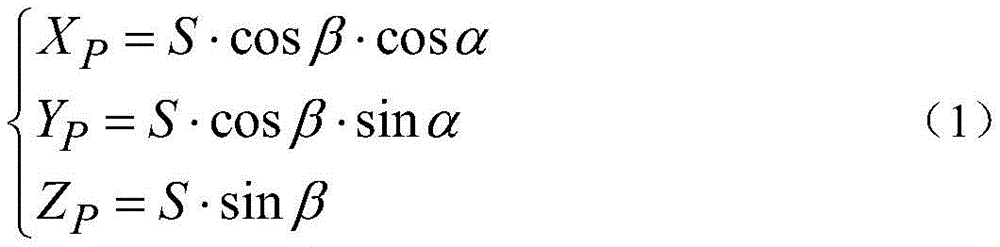
According to the measurement principle of the three-dimensional laser scanner (as shown in fig. 3), the three-dimensional laser scanner measures a target object in a polar coordinate mode and converts the target object into a three-dimensional rectangular coordinate through a formula (1);
three-dimensional coordinate value P (X) of measured target P ,Y P ,Z P ) The calculation formula of (2) is as follows:
wherein h is the set height of the scanner, S is the slant distance between the scanner and the scanning point, and the unit is mm; beta is the vertical direction angle of the laser beam, and the unit is DEG; alpha is the horizontal direction angle of the laser beam and has the unit of DEG; x P The coordinate value of the measured target on the X axis of the three-dimensional rectangular coordinate system is shown; y is P The coordinate value of the measured target on the Y axis of the three-dimensional rectangular coordinate system is shown; z P The coordinate value of the measured target on the Z axis of the three-dimensional rectangular coordinate system is shown;
the theoretical accuracy of the coordinates of the point positions measured by the scanner is deduced by the following steps:
sinβ=h/S
the point location error m of the scanner P Comprises the following steps:
in the formula, m X The length measurement error in the X-axis direction during measurement is unit mm; m is Y The length measurement error in the Y-axis direction during measurement is unit mm; m is Z The length measurement error in the Z-axis direction during measurement is also called elevation error and is unit mm; m is a unit of S The length measurement error in the direction of the skew angle s during measurement is in units of mm; m is α For measuring angle error in horizontal direction (horizon)Median error in angle), unit "; m is a unit of β The angle measurement error in the vertical direction (median error in pitch angle) at the time of measurement, in units "; rho is a second value corresponding to 1 radian and is 206265;
for three-dimensional scanning errors of a road surface, scanning point position errors and elevation errors are mainly considered. In the actual measurement process, because the scanner normally works during scanning, the error in distance measurement is determined as the theoretical distance measurement precision of the scanner, the error in angle measurement is determined as the theoretical angle measurement precision of the scanner, then the erection height of the scanner is determined, and the measurement point position error and the elevation error of the scanner are obtained through calculation.
Determining errors caused by the surface of the road surface in the three-dimensional scanning process; the specific process is as follows:
first, it is clear that the range measurement of a laser scanner depends mainly on the reflected laser signal of the measured object. The difference in the reflection characteristics of the surface of the object to be measured affects the intensity of the reflected laser signal and the information retention amount, thereby causing errors. For the surface of the asphalt pavement, the inclination of the reflecting surface, the surface roughness, the reflection characteristics and the like all affect the distance measurement precision.
For the error of the part, different road surface structures and measuring methods can cause different error sizes, but in general, the error can be eliminated by adopting a measuring method and skill of multi-station multi-directional block scanning.
Determining errors caused by a measuring environment in the three-dimensional scanning process; the specific process is as follows:
the main sources of environmental errors are temperature and humidity, air pressure, wind power and atmospheric refraction. For the error of the part, because the scanner is always in a normal working state in the process of scanning the road surface, the environmental error is within an allowable error range and is corrected when the scanner is calibrated, the error calculation and analysis are not performed.
Other steps and parameters are the same as those in the first embodiment.
The third concrete implementation mode: the present embodiment differs from the first or second embodiment in that: determining a point cloud registration error in the first step; the specific process is as follows:
unambiguous point cloud registrationBy means of Trimble RealWorks software, the method is non-target full-automatic registration based on the closest point Iteration (ICP) algorithm, namely, monotonic convergence of a result is realized by using a target function of distance square sum. According to a road table point cloud registration report generated by Trimble RealWorks software, obtaining an error epsilon between the total point clouds before and after registration Fitting for mixing 。
Other steps and parameters are the same as those in the first or second embodiment.
The fourth concrete implementation mode: the difference between the present embodiment and one of the first to third embodiments is that, in the second step, a point cloud denoising error in a model reconstruction process is determined; the specific process is as follows:
and performing deviation analysis on the points before and after the point cloud data is processed by utilizing Geomagic Studio software. The specific process of the deviation analysis comprises the following steps:
1) performing small-range multi-region high-precision free-form surface fitting on each point in the point cloud subjected to registration segmentation by using Geomagic Studio software, and setting the fitted free-form surface as T;
2) point Q (X) before denoising processing of point cloud Q ,Y Q ,Z Q ) (points are swept over the road surface by the scanner and then swept through to be point cloud data, i.e. a data set of a very large number of points. After that, the points are processed by software to obtain the road surface displayed on the computer, namely the road surface model. ) The projection point on the free-form surface T is P (X) P ,Y P ,Z P ) Then the distance from point Q to point P is:
wherein i is 1,2, …, n, n is the number of measuring points;
3) since the maximum distance, the average distance, the standard deviation of the distances, etc. can all be used as the accuracy index, the standard deviation of the distances from the point to the curved surface T is generally used as the accuracy index, as shown in formula (5):
the method can automatically obtain the deviation analysis result before and after point cloud denoising by utilizing Geomagic Studio software, and takes the standard deviation delta of the distance from a point to a curved surface T as a denoising error epsilon Noise reduction As shown in fig. 4.
Other steps and parameters are the same as those in one of the first to third embodiments.
The fifth concrete implementation mode: the difference between this embodiment and one of the first to fourth embodiments is: determining a triangulation network error in the second step and the third step; the specific process is as follows:
let V be the irregular triangulation network after triangulation network, and point A (X) before triangulation network A ,Y A ,Z A ) The projection point on V is B (X) B ,Y B ,Z B ) Then the distance from point a to point B is:
wherein i ' is 1,2, …, n ', n ' is the number of network nodes;
the standard deviation formula of the distance between the point clouds before and after the triangulation network is as follows:
similarly, the standard difference of the point cloud distance before and after triangulation is taken as triangulation error epsilon according to the deviation analysis result before and after triangulation by using point cloud automatically acquired by Geomagic Studio software Net As shown in fig. 5.
Other steps and parameters are the same as in one of the first to fourth embodiments.
The sixth specific implementation mode: the difference between this embodiment and one of the first to fifth embodiments is: determining a curved surface reconstruction error in the second step; the specific process is as follows:
definitely measuring the quality of the surface reconstruction from the irregular triangulation network model to the NURBS surface model by adopting the fitting error of the accurate surface. The solving process is to solve the standard deviation of the distance from the data point of the irregular triangulation network model to the corresponding NURBS curved surface, and the method specifically comprises the following steps:
the V midpoint of the irregular triangulation network after triangulation network construction is B (X) B ,Y B ,Z B ) The generated surface model S (the surface model S is a model when the surface model is finally built, and may also be called a NURBS surface model) is obtained by performing NURBS surface fitting on a model after triangulation (also called point cloud encapsulation). ) The projection point in (A) is C (X) C ,Y C ,Z C ) Then the distance from point B to point C is:
wherein, i ″ ═ 1,2, …, n ″, n ″ is the number of projection points;
the standard deviation formula of the distance before and after the curved surface reconstruction is as follows:
the standard deviation before and after the curved surface reconstruction can be obtained by utilizing the analysis result of the deviation before and after NURBS curved surface reconstruction automatically obtained by Geomagic Studio software, and the standard deviation of the distance before and after the curved surface reconstruction is taken as the error epsilon of the curved surface reconstruction Musical composition As shown in fig. 6.
Other steps and parameters are the same as those in one of the first to fifth embodiments.
The seventh embodiment: the difference between this embodiment and one of the first to sixth embodiments is: calculating the three-dimensional reconstruction total error of the road surface in the third step; the specific process is as follows:
and accumulating the errors of the point cloud obtained in the whole process of curved surface reconstruction to obtain the total error of the three-dimensional reconstruction of the pavement. The method comprises errors of 5 links, namely scanner errors, point cloud registration errors, point cloud denoising errors, triangulation network errors and curved surface reconstruction errors, and the transmission accumulation process calculation formula of the errors is as follows:
ε general assembly =f(ε Instrument +ε Fitting for mixing +ε Noise making device +ε Net +ε Musical composition )
Taking the root mean square of each error as the total error, the reconstructed total error is:
in the formula, epsilon General assembly Reconstructing a total error for the pavement three-dimensionally; epsilon Instrument for measuring the shape of a human body Is the scanner error; epsilon Fitting for mixing The point cloud registration error is obtained; epsilon Noise reduction Denoising the error of the point cloud; epsilon Net Is the triangulation error; epsilon Musical composition Is the curved surface reconstruction error.
The total error reflects the elevation deviation condition of data from the surface of the road surface to the virtual curved surface, serves as an error source for subsequent evaluation of road surface condition indexes, and can be adjusted and reduced by optimizing the curved surface reconstruction process according to different requirements of index errors.
Other steps and parameters are the same as those in one of the first to sixth embodiments.
The present invention is capable of other embodiments and its several details are capable of modifications in various obvious respects, all without departing from the spirit and scope of the present invention.