Background
The airborne weather radar has the functions of weather target detection, weather early warning and the like, and plays an important role in the military and civil fields. Radars specifically used for meteorological target detection were studied and manufactured from the 20 world 40 s for observing meteorological targets and studying meteorological conditions. At present, manufacturers of airborne weather radars mainly have two companies, Collins and Honeywell. The key technologies of the airborne weather radar comprise a turbulence and wind shear detection technology, a ground clutter suppression technology and full airspace weather information detection and evaluation, and the key technologies are research hotspots at home and abroad. When airborne weather radar is operating in the down-view mode, it is inevitably affected by ground clutter. When the radar transmits and receives signals downwards at a certain pitch angle, as shown in fig. 1, the weather clutter and the ground clutter signals exist in the same range gate at the same time in the echo. Because the ground scattered signal power in the radar receiving signal is extremely strong, meteorological clutter signals are completely covered in the echo, so that high-intensity meteorological false alarms appear in display equipment, detection and analysis of various meteorological targets are seriously influenced, and judgment of pilots is extremely easy to influence. In order to obtain complete meteorological target information in the space, the ground clutter component in the echo signal needs to be removed. Therefore, the research on the ground clutter suppression technology is very important.
Currently, the main ground clutter suppression technologies can be classified into the following categories: 1) ground clutter suppression technology based on multi-beam multi-scanning. Determining the scanning range of the main beam to the ground by using a geometric relation according to the flight path of the airplane, continuously adjusting the pitch angle of an antenna to generate echoes at different spatial positions, and then integrating data without clutter interference together to achieve the purpose of suppressing clutter; 2) a ground clutter suppression technique based on frequency domain. According to the model of the meteorological echo and the ground clutter, after Doppler compensation is carried out on the echo, the meteorological target and the ground clutter are distributed on different frequency domains, and a proper null-notch filter is designed according to the characteristic, so that the ground clutter component can be effectively inhibited; 3) clutter suppression technology based on spatial adaptive filtering. Because the meteorological target and the ground object target are at different heights, the airspace cancellation weighting coefficient is accurately estimated according to the echo data generated in the dual-channel mode, the two-channel cancellation is carried out by using the obtained cancellation weighting coefficient, and meteorological components are reserved after cancellation, so that the purpose of ground clutter suppression is achieved. 4) Ground clutter suppression in multi-polarization mode. The polarization scattering characteristic of the target can be utilized to identify non-meteorological signals caused by meteorological and ground-sea clutter, flying bird insects and the like, and the interference of the non-meteorological signals on radar display is reduced, so that the clutter suppression capability is further enhanced. In view of the above, many researchers have conducted intensive research at home and abroad.
In the technical scheme disclosed above, the scheme 1) is easily limited by flight conditions, and the medium-distance clutter suppression effect is not obvious; in the scheme 2), the frequency shift and the broadening of an echo frequency spectrum can be caused by the motion of a carrier, so that the difference between a meteorological target frequency spectrum and a ground clutter frequency spectrum is not very large, and the suppression effect is not obvious relative to a ground radar; in the scheme 3), due to the existence of uncertain factors such as channel amplitude-phase errors, antenna direction pointing errors and the like, the estimated airspace cancellation weighting coefficient is often deviated from an actual value, and the clutter suppression effect is influenced; scheme 4) the original data is difficult to obtain, the polarization information processing generally requires that the clutter polarization degree is high, and the motion of the airborne machine expands the clutter spectrum, thereby adding difficulty to the application of the polarization information in the airborne radar alone. In view of the above problems, how to effectively suppress ground clutter under various complex conditions is still a key problem to be solved in practical processing.
Disclosure of Invention
The invention provides a ground clutter suppression method of an airborne weather radar based on vertical array covariance matrix characteristic decomposition, which aims to solve the problem that ground clutter is difficult to effectively suppress under the influence of multiple factors in the prior art.
In order to achieve the purpose, the invention adopts the technical scheme that:
a ground clutter suppression method of an airborne weather radar based on vertical array covariance matrix characteristic decomposition comprises the following steps:
1) receiving data by adopting a vertical array antenna, and performing range-direction pulse compression processing on each path of signal;
2) constructing pitching dimensional airspace snapshot signals corresponding to each distance-pulse unit according to the multi-channel data after pulse compression;
3) estimating a pitch dimensional covariance matrix of each range-pulse unit airspace snapshot signal by using adjacent azimuth samples;
4) performing characteristic decomposition on the obtained pitch dimensional covariance matrix, and extracting a second characteristic value representing meteorological components;
5) and processing the distance-pulse units one by one, extracting a second characteristic value, storing the second characteristic value in the corresponding distance-pulse unit, and taking the second characteristic value as a final meteorological target output result.
Further, the process of receiving data by using the vertical array antenna in step 1) and performing range-wise pulse compression processing on each path of signal includes: the array elements in the array antenna system are arranged at the same interval in the vertical height, so that the received data of a plurality of channels are generated, and then the distance pulse compression is carried out on the generated echo data.
Further, the process of constructing the pitch-dimensional airspace snapshot signal corresponding to each distance-pulse unit according to the multi-channel data after pulse compression in the step 2) is as follows: and selecting the received data of each array element generated in the corresponding distance-pulse unit according to the pulse-pressed echo data obtained by the airborne weather radar vertical array antenna system, so as to form a corresponding pitching dimensional airspace snapshot signal.
Further, the process of estimating the pitch dimensional covariance matrix of each range-pulse unit airspace snapshot signal by using the adjacent azimuth samples in the step 3) is as follows: for the pitch-dimension airspace snapshot signals constructed by each distance-pulse unit, if the corresponding covariance matrix is estimated, the airspace snapshot signal samples with proper quantity in adjacent directions need to be selected, the autocorrelation matrix corresponding to each sample is calculated, and the pitch-dimension covariance matrix of the distance-pulse unit can be obtained by averaging the autocorrelation matrices.
Further, the characteristic decomposition is performed on the pitch dimensional covariance matrix obtained in step 4), and a process of extracting a second eigenvalue representing the meteorological component is as follows: when the channels are double channels, the pitch dimensional covariance matrix in the step 3) is subjected to characteristic decomposition to obtain two characteristic values, the first characteristic value is extracted for displaying the ground clutter, and the second characteristic value is extracted for displaying the meteorological clutter.
Further, the distance-pulse unit-by-distance-pulse unit processing in the step 5), extracting the second characteristic value and storing the second characteristic value in the corresponding distance-pulse unit, and the process of taking the second characteristic value as the final weather target output result is as follows: and 4) extracting second characteristic values of the meteorological components represented by the distance-pulse units according to the step 4), performing evolution operation on the second characteristic values extracted by all the distance-pulse units to obtain amplitude information of the meteorological target, and displaying the stored data to obtain a final output result of the meteorological target.
Compared with the prior art, the invention has the following beneficial effects:
the method is not influenced by the motion of the carrier and other error factors, and the estimation of the space domain weight cancellation coefficient is not needed. According to the airborne weather radar ground clutter suppression signal processing principle based on array signal processing, a vertical multichannel receiving radar system (or a pitching sum and difference beam antenna radar) is utilized, and as shown in figure 2, ground clutter and weather components in echo signals are separated through a space domain processing method. The method solves the problems that the ground clutter suppression performance is reduced and the like in the traditional method due to factors such as radar scanning limitation, Doppler spectrum broadening, inaccurate estimation of the space domain to the weight coefficient and the like, and is a practical ground clutter suppression method.
Detailed Description
The method for suppressing ground clutter of an airborne weather radar based on vertical array covariance matrix characteristic decomposition according to the present invention is described in detail below with reference to the accompanying drawings and embodiments.
Taking a dual-channel receiving system as an example, the covariance matrix of the estimated airspace snapshot signal is a two-dimensional square matrix, and two eigenvalues can be obtained after the two-dimensional square matrix is subjected to characteristic decomposition. The ground clutter component power in the echo signal is larger than the weather clutter and white noise component. Therefore, when the echo only contains the ground clutter component, the power of the ground clutter component is mainly concentrated in the first characteristic value, so the first characteristic value can approximately represent the ground clutter component in the echo, and the second characteristic value mainly represents the white noise power; and when the echo signal contains the meteorological clutter, the second characteristic value is obviously increased, and the meteorological clutter component power can be approximately represented.
In view of the principle, the invention provides a ground clutter suppression method based on covariance matrix characteristic decomposition. In the actual processing, the method can utilize the double-channel airspace snapshot signal to obtain a corresponding covariance matrix, perform characteristic decomposition on the covariance matrix to obtain two different characteristic values, and respectively store the two characteristic values correspondingly to obtain the corresponding ground clutter and the power component of the meteorological target.
For convenience of discussion, the multi-channel radar is set to a one-shot multi-receiving mode, as shown in fig. 2, the operating wavelength is λ, the number of receiving channels is N, and the receiving channels are uniformly arranged at an interval d. In the recording of echo data, ground clutter and meteorological clutter scattering points exist simultaneously in a certain distance ring, and the pitch angles are thetacAnd thetaw. The processing flow is shown in fig. 3, and the main steps are as follows:
1) receiving data by adopting a vertical array antenna, and performing range-direction pulse compression processing on each path of signal;
the echo signal is pulse-compressed in the frequency domain by using a conventional Matched Filtering (MF) method, and the pulse-compressed echo signal s (τ, t) can be represented as:
wherein s (τ, t) represents an echo signal generated by the target at the time t, τ represents fast time sampling, t represents slow time sampling, σ (x, y, z) represents a complex reflection coefficient corresponding to the space coordinate (x, y, z) of the target, g (t) represents a gain generated by an antenna directional diagram at the time t on the target, R (τ) represents the intensity of a transmitted pulse signal corresponding to the fast time sampling time τ, R (t) is the instantaneous distance from a reference channel at the time t to the target, c represents the light speed, j represents an imaginary unit, λ is a working wavelength, e is a natural constant, and π is a circumferential rate.
2) Constructing pitching dimensional airspace snapshot signals corresponding to each distance-pulse unit according to the multi-channel data after pulse compression;
after pulse compression, a spatial domain snapshot signal (N × 1-dimensional column vector) at a certain position represents spatial sampling data of N channels during receiving echoes, and the form of the spatial domain snapshot signal can be expressed as:
χ=αwsw+αcsc+n
wherein χ represents a spatial domain snapshot signal, n represents a white noise component in the snapshot, α is independent of other componentsw、αcRespectively representing the amplitude, s, of meteorological and ground clutterw、scSpace domain guide vectors of weather clutter and ground clutter, respectively, where sw、scCan be expressed as:
and
wherein N is the number of receiving channels, d is the distance between each receiving channel, and the pitch angles corresponding to the scattering points of the ground clutter and the gas image clutter are respectively thetacAnd thetawThe superscript T denotes the transposition operation.
3) Estimating a pitch dimensional covariance matrix of each range-pulse unit airspace snapshot signal by using adjacent azimuth samples;
the autocorrelation matrix R corresponding to the spatial snapshot signal χ can be expressed as:
wherein the superscript H represents the conjugate transpose operation, E {. is the mathematical expectation operation,
is white noise power, I
NIs an N multiplied by N dimensional unit matrix,
ground clutter and weather clutter power, respectively.
In a specific implementation, the calculation of the covariance matrix R may not only use one spatial snapshot signal at a corresponding position, but needs to estimate the autocorrelation matrix of the pitch and difference beams of each range-pulse unit by using adjacent samples, that is:
wherein,
and the covariance matrix obtained by estimation is represented, L represents the snapshot sample number of the data, and L represents the selected sample serial number.
4) Performing characteristic decomposition on the obtained pitch dimensional covariance matrix, and extracting a second characteristic value representing meteorological components;
it follows from step 2 that the autocorrelation matrix R is non-singular, and RHR is available as a positive hermitian square, so the characteristic decomposition of R can be written as:
wherein ∑ diag (λ)1,λ2,…,λi,λi+1,…,λN),viIs λiAnd corresponding eigenvectors, wherein U represents an eigenvector matrix formed by all the eigenvectors.
When N is 2, the feature decomposition is performed on R, and it can be obtained:
wherein λ is1>λ2Respectively representing a first eigenvalue, a second eigenvalue, v, of the matrix1、v2Is the characteristic corresponding to the first characteristic value and the second characteristic valueAnd (5) sign vectors.
5) Processing the distance-pulse units one by one, extracting a second characteristic value, storing the second characteristic value in the corresponding distance-pulse unit, taking the second characteristic value as a final meteorological target output result,
according to the step 4), the ground clutter components and the meteorological components of each distance-pulse unit can be respectively extracted, the characteristic value represents the echo power of the meteorological target, the evolution operation needs to be carried out on the second characteristic values extracted by all the distance-pulse units, the amplitude information of the meteorological target can be obtained, and the amplitude information is displayed to obtain the output result of the meteorological target.
Experiments prove that
The airborne meteorological radar ground clutter suppression method based on the vertical array covariance matrix characteristic decomposition provided by the invention is used for processing simulation and actual measurement data to carry out method verification, and the experimental result fully proves the effectiveness of the method.
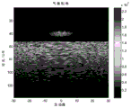
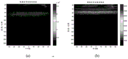
A surface feature target and meteorological target model is constructed, and two distributed meteorological targets are generated through simulation at 40 kilometers and 65 kilometers, as shown in figure 4. When the radar main beam touches the ground, part of the meteorological target may be masked due to the high echo intensity of the ground clutter, and the radar echo data generated at this time is as shown in fig. 5. The system parameters of the radar during simulation are as follows: the system bandwidth is 1.25MHz, the Pulse Repetition Frequency (PRF) is 1000Hz, the pulse width is 80us, the wavelength is 0.03 m, the distance gate is 100m, the flying height of the aircraft is 10 km, and the flying speed of the aircraft is 100 m/s. The Doppler frequency shift of a meteorological target generated by simulation is 300Hz, the spectral width is 200Hz, the Doppler frequency shift of ground clutter is 0, and the spectral width is 20 Hz. An analog radar four-channel receiving system. The echo data generated by simulation is processed by the method of the invention, the sum and difference channel original data is shown in figure 6, and the result obtained after processing is shown in figure 7. It can be seen that the ground clutter component is obviously suppressed, and the obtained meteorological component is consistent with the theoretical result, thus illustrating the effectiveness of the method. As can be seen from fig. 7, the ground clutter data contains residual meteorological components, because when the feature decomposition is performed, part of meteorological components are projected into the eigenvector corresponding to the first eigenvalue, the first eigenvalue increases, and the power of the meteorological target is also partially lost when the ground clutter suppression is performed.
And simultaneously, selecting two sets of airborne weather radar multi-channel measured data for verification. The system bandwidth is 1MHz, the Pulse Repetition Interval (PRI) is 2400us, the pulse width is 80us, the sampling frequency is 1.25MHz, the wavelength is 0.0356 m, the flying height of the aircraft is 6 kilometers, and the flying speed of the aircraft is 150 m/s. The first set of sum and difference channel actual measurement data output by the receiving end is shown in fig. 8, the left graph represents sum channel data, and the right graph represents difference channel data. The results obtained after treatment by the method of the invention are shown in FIG. 9. The second set of sum and difference channel measured data output by the receiving end is shown in fig. 10, and the processing result is shown in fig. 11. According to the processing result, the method can obtain a more ideal effect by suppressing the ground clutter, can display the meteorological target submerged by the ground clutter, can suppress the ground clutter more cleanly, achieves the purpose of suppressing the ground clutter and verifies the effectiveness of the method.
The above description is only of the preferred embodiments of the present invention, and it should be noted that: it will be apparent to those skilled in the art that various modifications and adaptations can be made without departing from the principles of the invention and these are intended to be within the scope of the invention.